Location: Fresno county, CA Map
Area: 462,901 acres (187,329 ha)
Official site
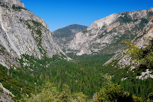
At 2,500 meters, Kings Canyon is the deepest valley in North
America. It is located in the southern Sierra Nevada in the US state
of California. The South Fork Kings River, the southern source of
the Kings River, rises in it. The valley is an Ice Age trough valley
and was carved out of the granite of the mountain range by glaciers.
The steep walls of the valley, which is narrow in the upper part,
qualify it as a gorge. Because there is no horizontal alignment, it
is not a canyon according to German usage.
Together with the
valley of the Middle Fork Kings River to the north and other smaller
areas, Kings Canyon is part of Kings Canyon National Park, which is
part of the Sequoia & Kings Canyon National Parks. Only the lower
part of the valley with an east-west orientation is accessible from
Fresno via the California State Route 180 cul-de-sac. The higher
altitudes can only be reached via mountain hikes or on pack tours by
horse or mule.
The headwaters of the South Fork Kings River
lie in a sprawling high valley with a number of mountain lakes at an
altitude of around 3,400 meters. The long-distance hiking trail John
Muir Trail runs through it, and the high valley can also be reached
by mountaineers from the Owens Valley on the eastern flank of the
Sierra Nevada via the 3,485 meter high Taboose Pass.
White settlers had known about Kings Canyon since
the mid-19th century, but it wasn't until John Muir visited the site
in 1873 that the canyon began to receive attention. Muir was
delighted by the canyon's resemblance to Yosemite Valley as it
reinforced his theory on the origin of both valleys, which at that
time competed with the most accepted of the time, that of Josiah
Whitney, who stated that the spectacular mountain valleys had been
formed by the action of earthquakes. Muir's theory was later proven
correct: both valleys had been carved by enormous glaciers during
the last ice age.
Then-United States Secretary of the
Interior Harold Ickes fought to create Kings Canyon National Park.
He hired Ansel Adams to photograph and document this and other parks
which largely led to the passage of the bill in March 1940 that
combined General Grant Grove with the wilderness beyond Zumwalt
Creek.
The future of Kings Canyon was in doubt for almost
fifty years. There was a project to build a dam at the western end
of the valley which many people opposed. The debate was settled in
1965 when the valley, along with Tehipite Valley, was added to the
park.
The park entrance fee is $20 for private vehicles
and $5 for individuals on foot or on bike, and is valid for seven
days in both Sequoia and Kings Canyon National Parks.
There
are several passes for groups traveling together in a private
vehicle or individuals on foot or on bike. These passes provide free
entry at national parks and national wildlife refuges, and also
cover standard amenity fees at national forests and grasslands, and
at lands managed by the Bureau of Land Management and Bureau of
Reclamation. These passes are valid at all national parks including
Sequoia and Kings Canyon National Parks:
The $80 Annual Pass
(valid for twelve months from date of issue) can be purchased by
anyone. Military personnel can obtain a free annual pass in person
at a federal recreation site by showing a Common Access Card (CAC)
or Military ID.
U.S. citizens or permanent residents age 62 or
over can obtain a Senior Pass (valid for the life of the holder) in
person at a federal recreation site for $80, or through the mail for
$90; applicants must provide documentation of citizenship and age.
This pass also provides a fifty percent discount on some park
amenities. Seniors can also obtain a $20 annual pass.
U.S.
citizens or permanent residents with permanent disabilities can
obtain an Access Pass (valid for the life of the holder) in person
at a federal recreation site at no charge, or through the mail for
$10; applicants must provide documentation of citizenship and
permanent disability. This pass also provides a fifty percent
discount on some park amenities.
Individuals who have volunteered
250 or more hours with federal agencies that participate in the
Interagency Pass Program can receive a free Volunteer Pass.
4th
graders can receive an Annual 4th Grade Pass that allows free entry
for the duration of the 4th grade school year (September-August) to
the bearer and any accompanying passengers in a private
non-commercial vehicle. Registration at the Every Kid in a Park
website is required.
In 2018 the National Park Service will offer
four days on which entry is free for all national parks: January 15
(Martin Luther King Jr. Day), April 21 (1st Day of NPS Week),
September 22 (National Public Lands Day), and November 11 (Veterans
Day weekend).
The Cañón de los Reyes National Park is made up of two sections. The
small section, designated the General Grant Grove section, protects
several giant sequoia forests including the General Grant Grove and the
famed General Grant and Redwood Mountain Grove , which is the largest
remaining natural grove of giant sequoias in the world (with a surface
area of 1,300 ha and more than 15,800 redwoods with a diameter of more
than 30 m). The park's giant sequoia forests are part of the 81,920 ha.
of primary forest shared by the Cañón de los Reyes and Sequoias National
Parks. This section of the park is mostly temperate coniferous forest
and is easily accessible via its paved roads.
The remainder of
the national park, comprising 90% of its total area, is located to the
east of General Grant Grove and forms the headwaters of the Middle and
South Forks of the Santos Reyes River and the South Fork of the San
Joaquin River . Both forks of the Río de los Santos Reyes comprise
extensive glacial canyons and a stretch of the canyon from the South
Fork, known as Cañón de los Reyes ( Kings Canyon ), gives the park its
name. The Canyon of the Kings, with a maximum depth of 2,500 m, is one
of the deepest canyons in the United States thanks to the action of
large glaciers on the granite of the place. The Kings Canyon and its
urbanized area,Cedar Grove , is the only portion of the main part of the
park that is accessible by motor vehicle. Both Cañón de los Reyes and
its twin, the middle fork known as Tehipite Valley, are deeply incised
U-shaped glacial valleys with relatively flat floors and towering
granite cliffs hundreds of meters high. The canyon also has various cave
systems, including Boyden Cave , open to the public.
To the east
of the canyons are the soaring peaks of the Sierra Nevada reaching an
elevation of 4,343m at the top of the North Palisade , the highest point
in the park. This is a typical Sierra highland landscape: barren alpine
ridges and lake basins filled in by glacial debris. These highlands are
usually free of snow in late June and late October and are only
accessible on foot or via horse tracks.
The ridges of the Sierra
form the eastern boundary of the park, from Mount Goethe north to
Junction Peak at the border of Sequoia National Park. Several mountain
passes cross the ridge into the park, including Bishop Pass , Taboose
Pass , Sawmill Pass , and the Kearsarge Pass . All these ports are over
3,400 m high.
The Canyon of the Kings is a wide glacial valley made up of high
cliffs, a meandering river, deep green streams and waterfalls. A few
miles outside the park the canyon gets deeper and its slope steeper
making it arguably the deepest canyon in North America by a slim margin.
The confluence of the middle and south forks of the Rio de los Santos
Reyes occurs at 690 m as Spanish Peak rises 3,064 m above the river on
the north side of the canyon.
Most of the mountains and canyons
of the Sierra Nevada are made up of granitic rock . These rocks, such as
granite , diorite , and monzonite , form when molten rock cools far
below the surface. This molten rock was produced as a result of a
geological process known as subduction . Powerful geologic forces forced
the land mass beneath the waters of the Pacific Ocean under the North
American plate . Superheated water carried along the subducted ocean
floor rises violently, melting rock in its path. This process took place
during the Cretaceous period., 100 million years ago. Granitic rocks
have a blotchy appearance because they contain various minerals
including quartz , feldspars , and micas .
Although geologists
debate the details, it is clear that the Sierra Nevada is a young
mountain range, probably less than 10 million years old. Massive forces
of the Earth's mantle, probably associated with the appearance of the
Great Basin , forced the growth of the mountains and their progressive
gain in altitude. During these 10 million years, there have been at
least four periods of glacial advance that have covered the mountains
with a thick layer of ice. glaciers _they form and grow during long
periods of cold, wet weather and flow through mountains like slow-motion
rivers that carve deep valleys and steep slopes. The combination of the
long history of glaciations in the mountain range and the erosion
resistant nature of the granitic rocks that make up most of the Sierra
Nevada have led to the creation of narrow valleys, waterfalls, abrupt
peaks, alpine lakes and glacial canyons.
Sequoia National Park and Kings Canyon campgrounds are located in oak forested areas on hot, dry foothills or in cooler softwood forests at higher altitudes. Its elevation ranges from 640 m to 2,300 m. Lodgepole, Dorst, Grant Grove and Atwell Mill campgrounds are near giant sequoia forests. Generally the higher altitude campgrounds are cooler and closer to the redwoods.