Location: Tacoma, WA Map
Area: 235,625 acres (953.5 km2)
Official site
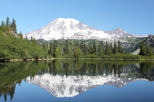
Mount Rainier National Park is a nature reserve near Tacoma, Washington in United States. Mount Rainier National Park covers an area of 235,625 acres (953.5 km2). Mount Rainier National Park was established on March 2, 1899 as the fifth national park in the United States, thus making it one of the oldest protected reserved in the country. It covers an area around an extinct volvano known as a Mount Rainier what dominates surrounding landscape at an elevation of 14,411 feet (4,392 m) above sea level.
The earliest signs of human presence around Mount Rainier National Park date back 6000 years ago. Arrow heads, tools and many other stone tools are found by tourists along hiking trails. Professional archaeological digs in te area of Mount Rainier National Park revealed ancient rock shelters near Fryingpan Creek, east of Goat Island Mountain. Carbon testing of the organic matter indicate that the site was inhabited by the ancient tribes from 900 to 1600 AD.
Mount Rainier National Park charges an entrance
fee of $15 per week per private vehicle (includes all passengers) or
$5 per week per individual person on foot, bike, or motorcycle. An
annual pass is available for $30, valid for one year from month of
purchase (does not cover camping fees).
There are several
passes for groups traveling together in a private vehicle or
individuals on foot or on bike. These passes provide free entry at
national parks and national wildlife refuges, and also cover
standard amenity fees at national forests and grasslands, and at
lands managed by the Bureau of Land Management and Bureau of
Reclamation. These passes are valid at all national parks including
Mount Rainier National Park:
The $80 Annual Pass (valid for
twelve months from date of issue) can be purchased by anyone.
Military personnel can obtain a free annual pass in person at a
federal recreation site by showing a Common Access Card (CAC) or
Military ID.
U.S. citizens or permanent residents age 62 or over
can obtain a Senior Pass (valid for the life of the holder) in
person at a federal recreation site for $80, or through the mail for
$90; applicants must provide documentation of citizenship and age.
This pass also provides a fifty percent discount on some park
amenities. Seniors can also obtain a $20 annual pass.
U.S.
citizens or permanent residents with permanent disabilities can
obtain an Access Pass (valid for the life of the holder) in person
at a federal recreation site at no charge, or through the mail for
$10; applicants must provide documentation of citizenship and
permanent disability. This pass also provides a fifty percent
discount on some park amenities.
Individuals who have volunteered
250 or more hours with federal agencies that participate in the
Interagency Pass Program can receive a free Volunteer Pass.
4th
graders can receive an Annual 4th Grade Pass that allows free entry
for the duration of the 4th grade school year (September-August) to
the bearer and any accompanying passengers in a private
non-commercial vehicle. Registration at the Every Kid in a Park
website is required.
In 2018 the National Park Service will offer
four days on which entry is free for all national parks: January 15
(Martin Luther King Jr. Day), April 21 (1st Day of NPS Week),
September 22 (National Public Lands Day), and November 11 (Veterans
Day weekend).
An entrance fee is not required to access any
of State Routes 410 or 123 on the east side of the park, including
the Ohanapecosh campground and visitor center.
Indigenous people
The first evidence of human presence in the
territory of the modern park dates back to about 4000-5800 years old.
They were found along the Bench Lake Walking Trail (the first part of
the Snow Lake Trail). A more significant archaeological find is a rock
shelter found near Frayingpan Creek, east of Mount Goat Island. Items
related to hunting were found in the shelter. Also, it can be assumed
that the shelter was not used throughout the year. The site was probably
used by the tribes of the Columbian Plateau about 1000-300 years ago.
In 1963, the US National Park Service entered into an agreement with
the University of Washington to study the use of the park by the
indigenous population of these places. Richard Dougherty conducted an
archaeological study of the area and concluded that the area was most
heavily used between 8,000 and 4,500 years ago. As a result of
interviews with elderly representatives of indigenous peoples and the
study of ethnographic literature, another scientist, Allan H. Smith, did
not find any evidence of permanent residence of the population in the
park. However, this area was actively used for hunting and gathering, as
well as for various rituals. In addition, Smith came to preliminary
conclusions that the territory of the park was divided along the
watersheds of the rivers between 5 tribes: Nisqually, Puyalup,
Makleshut, Yakama and Kaulits. However, subsequent research casts doubt
on Smith's theory that these tribes agreed on borders before they
entered into treaties with the United States in 1854-55.
Creation
of the park
On March 2, 1899, US President William McKinley signed a
bill passed by Congress authorizing the creation of Mount Rainier
National Park. At that time, Mount Rainier became the fifth national
park in the country. In addition, it was the first US national park
formed from a national forest. In 1893, the Pacific Forest Reserve was
formed, which included Mount Rainier. In 1897, the territory of the
reserve was enlarged, and it was renamed Mount Rainier Reserve. In 1898,
the famous American writer and conservationist John Muir visited the
reserve. Muir and a group of 9 climbed to the top of Mount Rainier, the
fifth recorded ascent of the mountain. The trip to Mount Rainier did
much to convince Muir to dedicate his life to conservation and the
creation of national parks. By that time, many national forests had been
created in the American west (at that time they were called "forest
reserves"), but Muir wanted to upgrade the status of these protected
areas to national parks, which, however, did not meet with much public
support in those years. During the 1890s, he managed to achieve the
creation of only one national park. When the Pacific Forest Reserve was
established in 1893, Muir turned to the newly formed conservation
organization the Sierra Club for support for the movement to create a
national park at Mount Rainier. Soon the National Geographic Society and
a number of scientific associations joined the movement, which, among
other things, were interested in preserving the territory as an object
for the study of volcanism and glaciology. The initiative was also
supported by a number of companies in Seattle and Tacoma, as well as the
Northern Pacific Railroad. The movement to create the park lasted over 5
years and included 6 attempts to push the bill through Congress.
Ultimately, Congress agreed to the creation of the park on the condition
that guarantees were provided that the land was unsuitable for
agriculture and mining, and also on the condition that federal funds
were not required to maintain the park.
2006 flood
Mount
Rainier National Park was closed following severe flooding caused by
heavy rainfall that hit the area on November 6, 2006. 460 mm of
precipitation fell in 36 hours. Most of the roads and campsites were
washed out. It wasn't until May 5, 2007 that the park was reopened to
motorists traveling on State Route 706 and entering the property through
the Nisqualee Gate.
On February 18, 1997, the entire park was designated as a National
Historic Landmark District of the United States in recognition of the
preservation of park architecture and its high quality. The park
includes 42 National Register of Historic Places, including 4 National
Historic Landmarks.
The park's most popular destination is the
area known as Paradise. The area is located on the southern slope of
Mount Rainier, at an altitude of about 1600 m above sea level. Of the
1.3 million visitors to the park in 2000, 62% came to Paradise. In this
part of the park there is an information and tourist center. Henry M.
Jackson (built 1966; demolished and rebuilt in 2008) and the historic
Paradise Inn built in 1916. The US National Park Service calls Paradise
the snowiest place on Earth. In the winter of 1971-72, 28.5 meters of
snow fell in this area, which was a world record for this winter.
The Longmire Tourist Information Center is located 10.5 kilometers
east of Nisqualee Gate. The center is located in the valley of the
Nisqually River, at an altitude of 842 m[16], between the Ramparts and
Tatoosh mountain ranges. Longmire is surrounded by relict forests of
Menzies' pseudohemlock, folded thuja, and western hemlock. Longmire is
the second most popular destination among park visitors (in 2000, 38% of
the 1.3 million visitors visited this place).
The Sunrise Tourist
Information Center is located in the northeastern part of the park, at
an altitude of 1950 m. This is the highest point in the park that can be
reached by car. There are many hiking trails in the Sunrise area.
In 2013, a rare relic species of two-winged insect Plesioaxymyia
vespertina was found here.