Location: Bellingham Map
Area: 684,000 acres (1,069 sq mi)
Official site
North Cascades National Park information center:
Tel: (360) 873 4500x39
When to come:
late July to October
Backcountry permit: required, free permit issued at Marblemount
North Cascades National Park is an American national park located
in northern Washington State, United States.
Covering an area
of 2,042.78 km2, this park is known for its mountainous landscapes
of the North Cascades Massif, the northern part of the Cascade
Range. The mountains, millions of years old, were born as a result
of the collision of the North American tectonic plate with plates of
oceanic origin. The watersheds of four rivers extend into the park
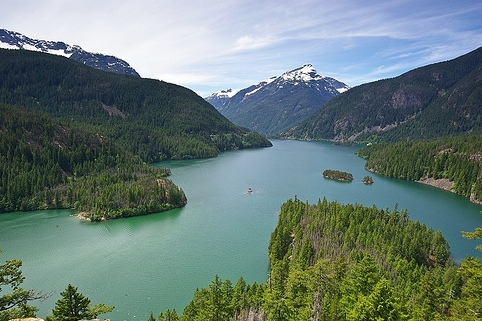
and more than 500 lakes are present there, including Lake Chelan,
which is ranked third nationally in terms of depth.
Human
occupation of the area dates back at least 8,500 years, when
Paleoamericans roamed it for hunting and gathering. After the
arrival of the first explorers of European origin, the local
Salish-speaking tribes were largely decimated by epidemics of
smallpox brought to the continent by settlers at the end of the 18th
century. During the 1950s, the region was a source of inspiration
for several American poets, including Jack Kerouac.
The park
was created on October 2, 1968 during the presidency of Lyndon
Johnson. Since then, the National Park Service has had the mission
of protecting its natural and cultural riches. The park thus
shelters more than 1,600 plant species and more than 300 species of
vertebrates. With other neighboring nature reserves, it is at the
heart of a huge protected ecosystem of more than 12,000 km2.
Cascade Pass Trail (North Cascades National Park)
Duration: 2 days
Distance: 9.4 miles (15.1 km)
Difficulty:
medium
Starting/ Finishing point: Cascade Pass Trailhead
Closest town: Marblemount, Stehekin
No public transport
Nearby
Johannesburg Camp is located at the Cascade Pass Trailhead that can
be achieved by taking a Cascade River Road. It is situated at an
elevation of 3600 feet above sea level. The trail leads to the
Cascade Pass (elevation 5,384 feet) and technically ends at the
western corner of the Stehekin Valley at Pelton Basin Camp
(elevation around 4800 feet). However you can continue via Horseshoe
Basin Trail to the Stehekin river below.
There are no fees to enter the North Cascades National Park. Spending the night in the back country does require a free permit obtained by registering at a ranger station. Campgrounds have variable fees, often dependent on the time of year and popularity of the campground.
Staying in the park means sleeping in a campground or in the back
country. For those who enjoy their amenities, however, there are
more posh accommodations in the countless towns one drives through
on the way to the park. One can find anything from hotel rooms to
chateaus with hot tubs.
Camping
There are a number of
campgrounds throughout the park, administered by the National Park
Service. Most offer potable water, dump stations, and firewood.
Backcountry
Most of the park would be classified as back
country. There are relatively few facilities outside of the
campground, baring a few composting toilets in more popular areas.
The park is located in northern Washington State, on the border with
the Canadian province of British Columbia. Its territory extends over
the counties of Whatcom, Skagit and Chelan. It is located approximately
150 km northeast of Seattle and 150 km southeast of Vancouver. The small
community of Marblemount is close to its western entrance.
About
75 km long for a width varying from 30 to 40 km, the North Cascades
National Park is, in reality, only part of a complex composed of four
distinct zones. The park itself is made up of a northern zone and a
southern zone. These two areas are separated by the Ross Lake National
Recreation Area at the Skagit River Valley. The fourth area, located at
the southern end of the complex, is the Lake Chelan National Recreation
Area.
The topography of the park is characterized by the mountain range of
the North Cascades, the northern section of the Cascade Range. This
massif is made up of many peaks whose altitude is between 2,000 and
2,500 m. The mountains, however, give an impression of grandeur compared
to the low altitude of the valleys. In the surrounding region, only a
few volcanoes manage to exceed the 3,000 m mark such as Mount Baker and
Glacier Peak.
The highest peak in the park is Goode Mountain,
which culminates at 2,806 m. The altitude of Lake Chelan, for its part,
does not exceed 336 m. Other prominent peaks located in the park include
Mount Shuksan (2,783 m), Buckner Mountain (2,768 m), and Mount Redoubt
(2,730 m).
The northern cascade chain belongs to the older part of the mountain
range and, unlike the southern part, is no longer primarily
characterized by volcanism. There is no younger volcano in the national
park itself, Mount Baker is a good 10 km west of the park, Glacier Peak
a little over 20 km south of the park, they both reach a height of over
3200 m. The mountains of the Northern Cascade Range are predominantly
composed of metamorphic rocks, predominantly gneiss and shale, with
granite intrusions.
They emerged in two phases. The oldest parts
arose from sediments that were deposited over a period of up to four
hundred million years on the western edge of what is now North America.
This happened through plate tectonic processes, in which island arcs and
sediments from former seabeds were pushed onto the continent. In the
process, massive pressure developed in the material, which led to the
metamorphosis of the rock. The sedimentary rock was transformed into
gneiss and slate. The northwest-southeast orientation of most mountain
ranges comes from the impact of a small tectonic plate about 90 million
years ago.
Around 40-35 million years ago, the Juan de Fuca Plate
began to impact the North American Plate. A subduction zone formed and
the melting material of the subducting Juan de Fuca Plate triggered
volcanism on the one hand and led to an uplift of the entire rock
complex on the other. As a result, erosion increased and the younger
rock layers were removed. So are all of the younger volcanoes in the
park area. Therefore, today the old, mostly metamorphic rock is exposed.
The current appearance of the mountains is shaped by the massive
glaciation in the Ice Age and to this day. The typical terrain features
are cirques and deep trough valleys, the prominent Mount Shuksan in the
northwest of the park is a Karling, formed by several glaciers that
emanate from its flanks and have eroded it into a pyramidal peak with
sharp ridges. The strong glaciation is the result of the location on the
west flank of the Cascade chain, which results in particularly high
rainfall.
The central valley of the Skagit River has been eroded
as a trough valley only to the east and west by two independent
glaciers. The middle section, roughly between Newhalem and Ross Dam, is
a notched valley dug by the river itself, which is now largely submerged
in the reservoir. Lake Chelan to the south is a classic tongue basin
lake.
Giant cedars and western hemlocks cover the wetter western valleys in particular, while subalpine firs, ruffled by the wind, form the transition to the subalpine mats. More than 1,500 plant species have been identified within the three areas of the National Park System, as well as hundreds of birds, reptiles, amphibians and thousands of insects. Bears, wolves, cougars and hawks are not very numerous but add to the genetic richness of this area. Between Newhalem and the border of Ross Lake National Recreation Area at Bacon Creek, mid-winter bald eagles can often be seen feeding on salmon along the Skagit River.
The North Cascades region was first explored by white explorers in the 19th century. The fur trader Alexander Ross is said to have been the first white person to travel to the region. From 1880 to 1910 miners prospected for gold, lead, zinc and platinum. They reported modest yields, but transportation was so difficult and profits so low that mining was abandoned. The first settlers and loggers came to the region around 1900. It was recognized early on that the Skagit River could provide electricity, and between 1924 and 1961 the Seattle City Light Electricity Company constructed three hydroelectric dams along the Skagit River, which today provide about a quarter of Seattle's electricity needs. On October 2, 1968, North Cascades National Park, Ross Lake National Recreation Area, and Lake Chelan National Recreation Area were established. In 1988, approximately 93 percent of these three areas were designated as Wilderness Areas by Congress under the name Stephen Mather Wilderness to permanently preserve their wilderness character.
Almost the entire national park is designated as a Wilderness Area,
so there are few facilities within the park. The National Park has a
visitor center at Newhalem which is open daily Spring through Autumn and
weekends during the winter. It offers natural and cultural history
information and exhibits, as well as audiovisual and ranger-guided
programs and short hiking trails. There are no entrance fees to enter
North Cascades National Park.
Hiking and mountaineering are the
most popular activities in the national park. In total, the protected
area offers more than 580 kilometers of hiking trails, on which you can
roam through all habitats in mostly multi-day hikes. The Pacific Crest
Trail also crosses the Stehekin River valley in the south of the park.
Seattle City Light offers regular tours of Diablo Lake and Ross Lake
dams. The reservoirs also serve as waterways leading into the remote
parts of these three National Park Service areas. Boats and motorboats
are available for rent from vendors in the National Recreation Area.
The park is the most dangerous national park in the United States.
Between 2007 and 2021, an average of 3.7 per 100,000 visitors died.