Location: 10 miles (16 km) southwest of Leadville, Lake County Map
Elevation: (4,401 m)
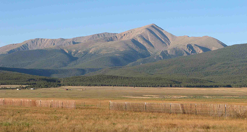
Mount Elbert is situated 10 miles (16 km) southwest of Leadville in Lake County in Colorado, United States. The mountain of Elbert reaches an elevation of 14,443 feet (4,401 m) and it is the tallest mountain in the lower 48 states. If anyone told you that climbing a mountain this tall will be a piece of cake, they lied. There certain things that me and my friends came over that caught us by surprise and created certain complications. It is not to discourage anyone from climbing (I think it is one of the best climbs in my life), but to share an experience so that you will be prepared.
High altitude sickness is not made up condition. In fact I affects almost all hikers from the low attitude cities who tried to climb too fast. It includes dizziness, headaches, sleep disorder, overall weakness and many other symptoms. In some rare cases it might take severe forms of edema of the brain and lungs. It affects people differently depending on age, health condition and adaptability. Aspirin, Motrin or whatever will work will certainly help with some of the signs of these condition, however the best way to climb is to take time and do it slowly. The base of the mountain is located at 10,000s feet above the sea level and for many who live in the cities at the low attitudes this might be enough to cause some discomfort and bad health conditions. I would suggest spending one or more nights at the base of the mountain. Visiting places like ghost town of Saint Elmo and various abandoned mines as well as hiking on small trails can help adapting to the climb. Most locals can spend a day climbing the mountain with little or no gear. However I would suggest breaking the climb into two days. It will help further in acclimatization to the surrounding conditions and it won’t put too much pressure. Spending a night on a summit is not the desirable.
If you decide to break the climb into two days, your base camp should be located in the forested area. Thunderstorm are quiet common in the area. Mount Elbert being the tallest mountain in the region attracts thunderclouds like an lighting rod. The easiest way to avoid getting killed by a lighting is to put your tent among tall trees. Lighting will strike that ever is the tallest structure. Setting a base camp on top of the mountain is not such a good idea since you automatically become the target from above. The second day of climbing the mountain should start as early as possible. If you see a thundercloud gathering over the peak you should stop and return back as soon as possible. Thunderstorm gather very quickly in the region and they get very dangerous very quickly. If you are caught on top of the mountain you go down as soon as possible. It is only once you get to the forested areas you can feel safe again.
There are no rangers in the area an no one will bother you with firing regulations, but it is a common sense that all fires should be extinguished once you leave the place. Forested part is full of dry wood. It is easy to find fuel for fire, but this also potentially can create huge forest fires.
Map of trails
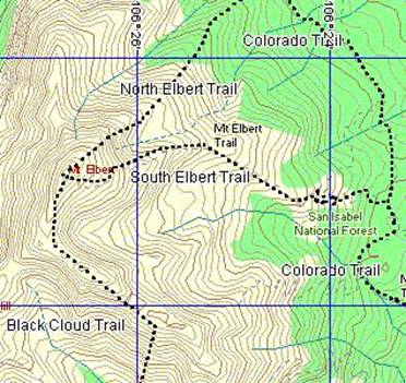
The easiest trail to climb is North Elbert trail. Both South and North Elbert trails can take a day to climb up and down. That is of course if you are adapted to high altitudes and start as yearly as possible. The hardest is the Black Cloud trail. Not fully shown, but it is the hardest and steepest approach. It would probably take two days. However it is very beautiful and you get to see both valleys once you get to the summit with twin lakes on one side and river on the other. It would be a good idea to buy topographic map with indicated trails, elevation and forested/ alpine region clearly marked.
Marmots
Very cute and social animal, probably due to the fact they live secluded lives. They are very interested in tourists and won’t cause any trouble, however they can (and they do) steal food so it would be probably better to scare them a little.
Abandoned mining camp
On Black cloud trail there is abandoned mining camp. This could be a good place to stop and rest before steepest climb. Just below burned building you can find a fireplace with huge logs for benches. Creek that is running nearby is a good and safe water source as long as you boil it. Some tourists drink straight from the creek, but it is not advisable.
The mountain is in the San Isabel National Forest. Denver is approximately 135 miles and Aspen is approximately 40 miles away. Mount Elbert is the highest mountain in Colorado. Like him, two neighboring massifs (Mount Massive and La Plata Peak) also belong in the Fourteener list (mountains over fourteen thousand feet high). The climatic conditions are very changeable, thunderstorms occur more often in the afternoon, and snow is possible all year round in the summit area.
Mount Elbert is part of the Sawatch Range. This originated in the
Laramian orogeny about 28 million years ago. The peaks in the area
used to be heavily glaciated. The glaciers left characteristic peak
formations and other features. For example, when the glacier receded
B. deposited on the east side volcanic and metamorphic rock. Also on
the eastern flank are basins with small, narrow mountain lakes. On
the north and south sides, natural dams created larger lakes such as
Turquoise and Twin Lakes.
Many large quartz deposits are
found on the mountain. However, the summit area of the mountain
consists mostly of Precambrian metamorphic rocks.
Compared to
other mountains of similar height, Mount Elbert has fewer firn
fields, which is due to the fact that the mountain's location and
shape is a less effective weather barrier than surrounding mountain
ranges, resulting in less rainfall.
The summit area is largely barren alpine terrain. Various plants can be found above the tree line that can survive in alpine altitudes (typical high mountain flora). Animal species such as the brown bear, marmots and gophers can be found in the different vegetation levels. Other typical representatives of the mountain fauna such as grouse, elk or ibex can also be observed, especially in summer.
There are three main routes to get to the summit. All three routes
overcome about 1200 meters in altitude. The standard route to the
summit can be accessed from the Colorado Trail, which runs through
the east flank. The 7.4-kilometer North Elbert Trail begins near
Elbert Creek Campground and climbs 1,400 meters. The trail is often
used by mountain bikers, horseback riders and, in season, by
hunters. An easier but longer route is the South Elbert Trail, which
is around 8.9 km long and climbs around 1,400 meters. From the south
you climb the eastern mountain flank.
The most difficult
route is via the Black Cloud Trail, which takes up to fourteen
hours, depending on the skills of the climber. Approx. 1600 meters
of altitude difference are overcome on this route. In addition, the
southern summit of Mount Elbert (4308 m) is exceeded. There are
other trails that start from the west and southwest, such as the
South Halfmoon Creek Trailhead and the Echo Canyon Trailhead.
All approaches require physical fitness, but special
mountaineering or climbing skills are not required. The greatest
danger on the mountain is the altitude. The occurrence of altitude
sickness cannot be completely ruled out, even for acclimatized
mountaineers.