Location: Map
Area: 11,700km²
Chobe National Park is a nature reserve situated in the Northern part of Botswana. It covers an area of 11,700km². Originally the region of Chobe National Park was inhabited by Basarwa people or San bushmen. These were hunter gatherers who left interesting rock paintings in different parts of the park. Much of the Chobe National Park is covered by savannah. During rainy season it blossoms with flowers, wetlands appear as rivers and lakes swell. During the dry season, however, the savannah turns less inviting. The grass turns yellow, desert overtakes large portion of the park and many animals gather close to water sources.
Originally it was populated by Bushmen. These
itinerant hunter-gatherers moved constantly in search of food, namely
fruits, water and wild animals. They left traces of their passage in the
form of paintings on rocks.
At the start of the 20th century, the
region that would become Botswana was divided into districts. At that
time, much of the current area of the park was classified as Crown
land. The idea of this national park was to preserve biodiversity
while promoting tourism which appeared as early as 1931. The following
year, 24,000 km2 around the Chobe district were officially declared as a
game reserve, this area being enlarged two years later to reach 31,600
km2.
In 1943, a severe epidemic spread by the tsetse fly delayed
the creation of the national park. In 1953, the government again became
interested in this project, which led to the creation of a 21,000 km2
animal reserve, smaller than originally planned, in 1960. In 1967, the
reserve became a park national.
At that time there were several
industrial establishments in the region, particularly in Serondela where
the wood industry was very present. These settlements were gradually
moved outside the park and it was not until 1975 that human activity
completely disappeared from the protected territory. Today you can still
see remnants of the timber industry in Serondela. The park was slightly
expanded twice in 1980 and 1987.
The park is divided into four parts, each corresponding to a
different ecosystem.
The Serondela area (the bank of the
Chobe River), located in the far northeast of the park, is
characterized by a lush floodplain and a forest of mahogany, teak
and other hardwoods that has been markedly reduced because of the
high density of elephants. The Chobe River, which represents the
northeastern limit of the park, is an important watering point,
particularly during the dry season (from May to October), for
elephants, but also giraffes or buffaloes. Many birds are also
present, such as the carmine bee-eater visible in numbers during the
dry season. When the water level is high, spoonbills, ibises and
different species of storks, ducks or Anseriformes migrate to the
river. This is probably the most visited part of the park, largely
because it is close to Victoria Falls. The town of Kasane, located
next door, the largest town in the region, serves as the northeast
gateway to the park.
The Savuti Marsh area (10,878 km2)
constitutes the western part of the park (50 km north of the Mababe
gate). Savuti Swamp is the remnant of an ancient lake whose water
supply was cut off long ago by tectonic movement. Today, it is fed
by the Savuti channel, which dries up for very long periods and
suddenly starts flowing again, due to tectonic movements. It last
flowed to the swamp in January 2010, the previous time being in
1982. As a result of this very erratic flow, there are many dead
trees all along its shoreline. The region is also covered by
savannah and grassland which is renewing itself, allowing the fauna
to be particularly prosperous. During the dry season, tourists who
go on safaris can see rhinos, warthogs, kudus, impalas, zebras,
wildebeests but also African elephants. During the rainy season, the
450 species of birds in the park are well represented. Groups of
lions, hyenas, and more rarely cheetahs can also be seen there. The
area is famous for the annual migration of zebras and predators.
Linyanti Swamp, located northwest of the park and north of
Savuti Swamp, is adjacent to the Linyanti River. To the west of this
area is the Selinda Game Reserve, while on the northern bank of the
Linyanti River is the Nkasa Rupara National Park in Namibia. Near
these two rivers are forests and lagoons, the rest being mostly
floodplains. This part of the park contains a large concentration of
lions, leopards, wild dogs, roan antelopes, black antelopes, hippos
and African elephants. A few lechwe waterbucks, bushbucks or even
Nile crocodiles can also be seen, although they are rarer. Birds are
very present in this region.
Between the Savuti and Linyanti
swamps is a dry and hot area occupied mainly by the forests and
grasslands of Nogatsaa. This part is less known but is a very good
place to see elands.
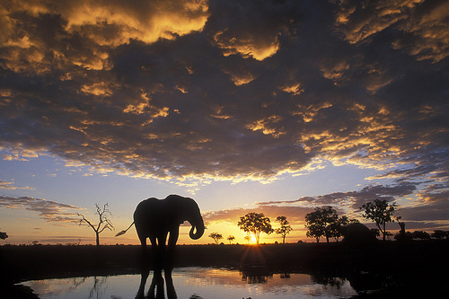
Chobe National Park has a significant elephant population, which has
been steadily increasing during the 20th century and is currently
estimated at about 120,000. The Chobe elephant is migratory, migrating
up to 200 km from the Chobe and Linyanti rivers, where they concentrate
in the dry season, to the depressions in the southeast of the park,
where they disperse in the rainy season.
In addition to
elephants, much other wildlife can be seen, especially in the dry winter
months. It is on these dates when large concentrations of elephant,
buffalo, zebra, giraffe, impala and other animals gather along the river
to drink. Chobe National Park is a major destination for wildlife
viewing of all kinds, and a must-see safari option for the traveler,
especially river safaris.
The condition of the trails in the park is highly dependent on the
season and the rain and it is best to have an all-terrain vehicle to get
around. Sand can become a problem on the banks of the Chobe River during
the dry season, especially when it is hot. Conversely, during the rainy
season, the tracks become muddy.
Savuti
Savuti tracks are
very sandy and require some driving experience. After rain, driving near
swamps presents the risk of getting stuck.
Nogatsaa
The tracks
of Nogatsaa are wet during the rainy season and few of them are passable
in this season. During the dry season, the tracks to go from one valley
to another are very small and sandy. Once you have left the paved road
coming from Kasane, you will have to do 20 km on very sandy tracks
before arriving on tracks in better condition.
Since Botswana is in the southern hemisphere, the seasons are
reversed compared to the northern hemisphere, and because of the
country's location in the tropics, the rains are seasonal and monsoonal
in nature.
The hottest month in Chobe is October, with maximum
temperatures of 36ºC and minimum of 20ºC. During the southern winter,
the coldest months are June and July, with a minimum of 6ºC and a
maximum of 25ºC. It is very rare for temperatures to drop below zero
degrees Celsius.
Humidity is between 42 and 78 percent during the
peak of the wet season, in January and February, and between 20 and 40
percent in the dry season, from September to October. The wet season
begins between November and December, and ends between March and April.
In the dry season it may rain some day. The average rainfall is between
550 and 650 mm per year.
Chobe Park is renowned for being the place with the highest concentration of elephants in Africa (around 120,000 individuals live in the park). This population has been growing continuously since 1990, a time when there were a few thousand specimens in the park. Despite the large concentration of elephants, the Chobe administration has so far refused to adopt the artificial population reduction measures employed by other parks.
The park includes numerous accommodation facilities for tourists, including several camping areas and many lodges. Malaria is present in the area where the park is located.
The traveler heading to Chobe can buy a detailed map of the place at
gas stations. On the same map, The Shell map of the Chobe National Park,
there is a list of the animals that can be seen in the park.
African Loxodonta - African elephant
Hippopotamus amphibius - common
hippopotamus
Camelopardalis giraffe - giraffe
Phacochoerus
africanus - phacozero
Phacochoerus aethiopicus - Eastern phacoceros
Syncerus caffer - caffer buffalo
Taurotragus oryx - common eland
Tragelaphus strepsiceros - great kudu
Tragelaphus species — not sewn
Tragelaphus scriptus - hieroglyphic antelope or bushbok
Connochaetes
taurinus - blue grass or listed
Damaliscus lunatus - topi
Hippotragus niger - sable antelope
Hippotragus equinus - Rwandan or
equine antelope
Kobus ellipsiprymnus - aquatic antelope
Kobus milk
- antelope milk
Kobus vardonii - white
Redunca arundinum - common
or southern redunca
Aepyceros melampus - impala
Sylvicapra grimmia
- common or gray duiker
Raphicerus campestris - common raphice or
steenbok
Ceratotherium simum - white rhinoceros
We say bicornis -
black rhinoceros
Equus burchelli - Burchell's zebra
Crocuta
crocuta - spotted hyena
Brunnea hyena - brown hyena
Proteles
cristatus - earthwolf or proteles
Lycaon pictus - African lycaon or
wild dog
Canis mesomeles - common or black-backed jackal
Canis
adustus - striped jackal
Otocyon megalotis - fox eyed or ototion
Civettictis civetta - African civet
Genetta genetta - common horse
Mungos mungo - mungo or mangosteen listed
Sanguinella gallerella -
rufa mangosteen
Helogale parvula - mother mangoes
Leo panther -
lion
Brown Panthera - leopard
Acinonyx jubatus - cheetah
Caracal caracal - caracal (also Felis caracal)
Leptailurus serval -
serval (also Felis serval)
Felis silvestris lybica - African mountain
cat
Aonyx capensis - Cape inert otter
Mellivora capensis - ratel
or male badger
Ictonyx striatus - Libyan or North African fox
Orycteropus afer - ant hog
Manis temminckii - Temmick or terrestrial
pangolin
Papio ursinus - Chacma papion or black papion
Cercopithecus aethiops - green or whole cercopithecus (also Chlorocebus
aethiops)
Galago senegalensis - Lesser gazelle
Lepus saxatilis -
scrub hare
Paraxerus cepapi - African arboreal squirrel ?
Pedetes
capensis - Cape hare or jumping hare
Hystrix africaeaustralis - Cape
porcupine