Location: Masvingo Map
Area: 722 hectares (1,780 acres)
Great Zimbabwe (also Old Zimbabwe, English Great Zimbabwe) is a
ruined city located 39 kilometers from Masvingo in Masvingo Province
in Zimbabwe. The name Zimbabwe means Great Stone Houses or Honored
Houses depending on the dialect. The settlement on the plateau of
the same name was the capital of the Munhumutapa Empire (also
Monomotapa Empire), which also included parts of Mozambique in
addition to today's Zimbabwe. In its heyday from the 11th to the
mid-15th century, Greater Zimbabwe had up to 18,000 inhabitants, was
used by the monarchs of Zimbabwe as a royal palace and was the
center of political power. The wealth of the metropolis was based on
cattle breeding, gold mining and long-distance trade. Evidence of
the spiritual center are the Zimbabwe birds made of soapstone. The
complex is the largest pre-colonial stone structure in sub-Saharan
Africa and one of the oldest.
The city was already deserted
and falling into disrepair when Europeans first saw it in the 16th
century. For a long time it was erroneously interpreted as the home
of the Queen of Sheba. However, the results of archaeological
research refute this thesis; the date of origin of the complex is
assumed to be the late Iron Age, which corresponds to the 11th
century in this region.
The ruins of Greater Zimbabwe have
featured on Zimbabwe's national coat of arms since 1981 and have
been on the UNESCO World Heritage List since 1986.
Location
Greater Zimbabwe is located 240 kilometers south of the
capital Harare and about 25 kilometers south-southeast of Masvingo,
formerly Fort Victoria, in Masvingo Province in the southern half of
Zimbabwe. The ruins are at an altitude of 1140 m. Immediately to the
north, about two kilometers away, begins the landscape park Mutirikwi
Recreational Park with Lake Kyle and Lake Mutirikwi. This reservoir
covers about 90 km² and has been dammed since 1960 when the Kyle Dam was
built on the Mutirikwi River, a tributary of the Runde.
The
location on this plateau offered the city natural protection against
sleeping sickness (African trypanosomiasis). Spread by the tsetse fly,
this disease can kill humans and cattle, but tsetse flies are only found
in low-lying areas.
Southwest of the ruins is the Morgenster
Mission, a mission station and hospital built by John T. Helm in 1894 on
behalf of the Dutch Reformed Church.[3] To the north is the road to
Masvingo, and to the east is the small town of Dorogoru.
outline
The site covers a fenced area of 722 hectares and is divided into four
parts: on the hill is the so-called mountain ruin, in the valley floor
to the south are the enclosures, to the east is the Shona village museum
and to the west of the enclosures is the modern infrastructure with a
hotel, Campsite, administrative buildings and access roads.
To
the south of the mountain ruins, a relatively wide valley opens up, in
which stand the enclosures, of which the Great Enclosure is the
southernmost structure. To the west, from north to south, are Outspan
Ruins, Camp Ruins, and Hilltop Ruins. The remaining, smaller ruins are
primarily named after their respective explorers: just north of the
Great Wall are Ruins #1, Posselt Ruins, Renders Ruins, and Mauch Ruins.
East of this are the ruins of Philips, the Maund and the East.
Geology
The area on which the ruins of Great Zimbabwe are located is
about 110 kilometers east of the Great Dyke, where coveted precious
metals, especially gold, were mined. The subsoil of Greater Zimbabwe
itself is predominantly granite with massive veins of gneiss formed by
contact metamorphism in the early Precambrian. Geological investigations
revealed that the granite blocks used to build the walls were mainly
biotite-based. The composition is 35% quartz, 58% feldspar (microcline
28%, plagioclase 30%), 4% biotite, 3% muscovite and less than 1% iron
ore. Diorite was used as a harder stone to work the granite for the
buildings.
Climate
The place is located in a subtropical to
tropical climate zone with humid, sometimes hot and humid summers and a
dry winter season. The average annual temperature in Greater Zimbabwe is
between 20.8 and 26.1 °C. The warmest months are October and November
with an average of 29.2 and 28.7 °C respectively, the coldest June and
July with a minimum average of 5.8 and 5.4 °C. The temperature almost
never drops below freezing. Most precipitation is recorded in December
with an average of 140 millimeters, the lowest in June and July with an
average of 3 and 6 millimeters. Because of the summer monsoon,
precipitation falls particularly in the period from mid-November to the
end of January; the annual average is 614 millimeters. However,
according to Innocent Pikirayi, a lecturer in history and archeology at
the University of Zimbabwe and familiar with the excavation site, the
rainfall for the area around the ruins is said to be higher, at 800 to
1000 millimeters a year, which would mean that agriculture was more
productive.
Vegetation
Mythical significance is ascribed to
vegetation in Greater Zimbabwe, particularly the mobola plum or muhacha
(Parinari curatellifolia), a golden plum family. Exotic introduced
plants that dominate the site today are the jacaranda (Jacaranda
mimosifolia), the eucalyptus and the lantana (Lantana camara). The ruins
have been overgrown over time by many specimens of red milkwood
(Mimusops zeyheri, from the genus Sapodaceae) and by a shrubby nettle
(Girardinia condensata).
Name
There are two theories about the origin of the word "Zimbabwe": The
first holds that the word is derived from Dzimba-dza-mabwe, translated
from the Karanga dialect of the Shona as "big house of stone" (dzimba =
the houses, mabwe = the stone) or also large stone house/stone palace
(the prefix z- marks a form of enlargement like the Italian suffix
-one). The Karanga-speaking Shona live around Great Zimbabwe; they
probably already inhabited the region when the city was built. The
second thesis postulates that Zimbabwe is a contracted form of
dzimba-hwe, meaning "honored houses" in the Shona Zezuru dialect, a term
used for the tombs and houses of the chiefs. The city was named after
the state of Zimbabwe (also Zimbabwe, formerly Southern Rhodesia).
The suffix "Great" is used to distinguish around 150 smaller ruins,
called "Zimbabwes", which are spread all over the country of Zimbabwe.
There are also about 100 Zimbabwes in Botswana, while the number of
Zimbabwes in Mozambique cannot yet be estimated.
Iron Age History
The area around Greater Zimbabwe was settled in the period from 300
to 650 AD. Rock paintings in Gokomere, about eight kilometers from
Masvingo, bear witness to this. The Gokomere/Ziwa tradition, with its
distinctive pottery and use of copper, is archaeologically associated
with the Iron Age. However, the Ziwa culture did not erect stone
buildings.
The first farming settlements in Mapungubwe on the
Limpopo date from around the year 900. The kingdom there existed between
1030 and 1290; with its decline due to changing climatic conditions, the
rise of Greater Zimbabwe began. On the plateau of Greater Zimbabwe,
hunter-gatherers, Iron Age agriculture and societies based on the
division of labor seem to have collided directly. Several states
emerged, sometimes one after the other, sometimes in parallel. Greater
Zimbabwe was the first center of the Mutapa Empire, whose power extended
to the coast and also north and south of present-day Zimbabwe. Khami, a
similarly large complex of walls seven kilometers west of Bulawayo,
first arose parallel to and later became the center of the Torwa Empire.
The Kingdom of Munhumutapa
Greater Zimbabwe is one of the oldest
stone structures south of the Sahara. Work began in the 11th century and
continued until the 15th century. There is strong evidence, but no
conclusive evidence, that the builders and residents of the city were
ancestors of the modern-day Shona, the Bantu people who make up about
eighty percent of the population of the present-day Republic of
Zimbabwe. The ceramics found are very similar to those of today.
However, since this culture did not develop writing, there is no
definitive proof. In the heyday, 20,000 people are said to have lived on
the site. Trade connections with Arabian coastal cities are
archaeologically proven by coin finds. However, in addition to numerous
objects from the heyday, pottery was also found in the area, which is
600 years older than the buildings. The country's wealth in gold was the
main reason for the commercial activities of Arab and Persian traders on
the southern tip of Africa and for the founding of Swahili cities in
Mozambique. Around 1450 Greater Zimbabwe was abandoned, probably because
the high concentration of population had exhausted the country. The
Mutapa state shifted its center north and lost its supremacy to the
Torwa state. The new center became its capital Khami for about 200
years.
Expeditions and Archaeological Research
Portuguese
expeditions and their reception
The Portuguese were the first
Europeans to establish a fort near Sofala at the beginning of the 16th
century and tried to get their hands on the South African gold trade.
They therefore sought Mwene Mutapa, the head of the Karanga kingdom. A
1506 letter from Diego de Alçacova to the Portuguese king states that in
Zunbahny, the capital of the Mwene Mutapa, "the king's houses ... are of
stone and mud, very large and on one level". In 1511, the Portuguese
explorer António Fernandes was the first European to visit the site. He
reported that "Embiere... was a fortress of the king of Menomotapa...
now of stone... without mortar." They also carried the legend to Europe
that the city was the home of the Queen of Sheba. In 1531, Vicente
Pegado, captain of the Portuguese garrison at Sofala, described Greater
Zimbabwe: “Amid the gold mines on the inland plain between the rivers
Limpopo and Zambesi stands a fortress built of astonishingly large
stones and without any mortar... This The structure is almost entirely
surrounded by hills on which similar structures made of stone without
mortar stand. One of these structures is a tower over 22 meters high.
The natives of the country call these structures Symbaoe, which means
courtyard in their language.” João de Barros published the report in
1552 in his work Décadas da Ásia. The information was based primarily on
descriptions by Swahili traders in Sofala.
The other mention of
stone buildings in this early period is found in Ethiopia Oriental,
published in 1609, by João dos Santos, who had been a missionary in the
country of Mwene Mutapa between 1586 and 1595. However, his statements
refer to stone buildings at the other end of the plain, opposite Great
Zimbabwe, on Mount Fura (today Mount Darwin) in Mashonaland:
“Some fragments of old walls and ancient ruins of stone and mortar
still stand on the top of this mountain. ... The natives ... affirm:
They had been told by their ancestors that these houses once represented
a trading post of the queen of Sheba. Large quantities of gold were
brought from here, which were transported by ship down the Cuamas rivers
to the Indian Ocean... According to others, the ruins come from a
settlement of King Solomon. . . . I can't vouch for it, but I do claim
that Mount Fura or Mount Afura could be the "land of Ophir" from whence
gold was brought to Jerusalem. This would give some credence to the
claim that the buildings in question were a trading post of King
Solomon.”
Shortly after dos Santos published his report, Diogo de
Couto, the successor of João de Barros, added in the work De Asia that
"it is supposed that ... the Queen of Sheba ... gold was mined in these
places ... the great stone buildings ...are called Simbaoe by the
Kaffirs, and they are strong fortifications." Although de Barros and dos
Santos recognized that they were engaging in questionable speculation,
the ideas they presented to the public so stimulated the imagination of
their recipients that their description two hundred Repeated for years
by Europe's finest geographers, it "acquired exotic accompaniments to
the same extent that speculation, which still had something to do with
conceptual thinking, turned into unquestioningly accepted dogma." Such
repetitions are found in the works the Italians Livio Sanuto (1588) and
Antonio Pigafetta (1591), the English Samuel Purchas (1614), John Speed
(1627), John Ogilby (1670), Peter Heylin (1656) and Olfert Dapper
(1668), and the French Jean-Baptiste Bourguignon d'Anville (1727) and
Charles Guillain.
The Expedition of Karl Mauch (1871)
After
Adam Renders (1822–after 1871) rediscovered the ruins while hunting in
1868 and claimed that “they could never have been built by blacks”, he
showed them to Karl Mauch (1837–1875) in 1871 on his fourth voyage to
southern Africa . In the years that followed, he equated it with the
biblical gold land Ophir, i.e. 2000 years earlier than today's
radiocarbon dating. He then passed the upper reaches of the Zambezi,
where he found a gold field (Kaiser Wilhelms field). In 1872 Mauch,
suffering from malaria, returned to Germany. He later questioned his own
Ophir Zimbabwe theory. The first publication by Alexander Merensky on
the Zimbabwe ruins appeared in Petermanns Nachrichten in Berlin in 1870.
In it he had summarized research reports.
The Expedition of James
Theodore Bent (1891)
When Cecil Rhodes conquered Mashonaland in
September 1890 with the help of the British South Africa Company, he
told local Bantu chiefs that he had come to see "the ancient temples
that once belonged to the white man". With William G. Neal, the head of
the Ancient Ruins Company, who had carried out illegal excavations on
this and other Iron Age sites in Zimbabwe and thereby destroyed
important findings, he commissioned James Theodore Bent (1852-1897) in
1891 to examine the ruins.
Bent's archaeological experience was
that he had traveled to the countries of the eastern Mediterranean and
the Persian Gulf in search of the origin of the Phoenicians. As an
archivist, he seems to have had a liking for archaeology, but no
archaeological training – and even less practical experience. In June
1891, Bent began excavating around the conical tower in the elliptical
structure and was very disappointed with the results. He later claimed
the ruins were built by either Phoenicians or Arabs. However, his
reports made the ruins known to a wider circle of English readers.
Much of the archaeological stratigraphy was destroyed during the
excavation by Bent's team, making it more difficult for later
archaeologists to determine the age of Greater Zimbabwe. Bent's team
eventually suggested that a "bastard" race of white immigrant males and
African women had constructed the structures. During Bent's research,
the ruins were surveyed by mining engineer Robert Swan. Based on his
plans, Swan developed his own theories, which assumed precise designs
based on the number pi for the larger sections of ruins. Based on Swan's
observations - and his claim that in the centers of the elliptical
arches there were now vanished altars that were aligned with the
solstices - the geologist Henry Schlichter later tried to calculate the
absolute age of the due to their natural variability. He came up with
1000 BC. However, since Swan's measurements were erroneous and made at
random points, this theoretical edifice proved untenable.
Peter
Garlake pointed out that in 1892 the British army officer, Major Sir
John Christopher Willoughby, "without any regard for casualties"
"gutted" three ruins in the valley, destroying the stratigraphic layers
within the north-west entrance to the Great Enclosure .
The
Expedition of Carl Peters (1899)
Carl Peters (1856-1918) led a
research trip to the Zambezi in 1899. He wanted to prove that the
biblical land of gold, Ophir, was in Southeast Africa. Since, in the
later judgment of the historian Joachim Zeller, he "represented National
Socialist positions, a rigid master's point of view and racist social
Darwinism", he could not imagine that the ruins of Greater Zimbabwe
could have African origins. He therefore looked for master builders from
the Middle East, in which he attributed a central role to the
Phoenicians. Peters was also interested in attracting shareholders to
his corporation, which was acquiring land in Portuguese Mozambique to
prospect for gold there. Peters enriched his Ophir theory with violent
defamation of black Africans and demanded the introduction of general
forced labor in the colonies.
The dig of Richard Nicklin Hall
(1902–1904)
The discovery of several gold finds in the 1890s at the
Dhlo Dhlo ruins led to the establishment of Rhodesia Ancient Ruins Ltd.,
which systematically searched 50 ruins in Zimbabwe for gold finds, but
at the express wish of Cecil Rhodes excluded the ruins of Greater
Zimbabwe. The excavations yielded only 178 ounces of gold jewelry. The
company was disappointed by the other finds. The results of the campaign
were compiled into a book by local journalist Richard Nicklin Hall.
After several financial difficulties, Hall was appointed Curator of
Zimbabwe in 1902, charged with protecting Greater Zimbabwe under new
legislation. Due to two extensions, Hall performed this function for
almost two years instead of the originally planned six months. His
instructions consisted in carrying out "no scientific investigations"
but to devote oneself solely to "the preservation of the structure".
After Garlake, Hall didn't care what the purpose of his appointment was.
Instead, he had undocumented excavations carried out in the Great
Enclosure, the Hill Ruins, and much of the other valley ruins. Not only
were the trees, aerial roots and undergrowth and spoil heaps removed
from the Bent and Willoughby digs, but also 0.9-1.5 metres, in places
more than 3 metres, of stratified archaeological material. His
justification for what he himself called "a modern and timely work of
conservation" was that he was only clearing away the "filth and refuse
of the Kaffir people" with a view to uncovering the remains of the
"ancient" builders. After the criticism grew louder, especially in
scientific circles, the London office of the British South Africa
Company finally canceled the contract and dismissed Hall in May 1904.
The dig by David Randall-MacIver (1905/1906)
The first scientific
archaeological dig at the site was conducted in 1905/1906 by David
Randall-MacIver (1873-1945), a student and collaborator of Flinders
Petries. In the short time available to him, MacIver dug first in the
ruins of Injanga, Umtali, Dhlo Dhlo and Khami and then with this
experience in Greater Zimbabwe. He was the first to describe the
existence of find objects in "medieval Rhodesia" that can be assigned to
the Bantu. The absence of any artifacts of non-African origin led
Randall-MacIver to suspect that the constructions were carried out by
native Africans. In doing so, he set himself apart from earlier scholars
who wanted to attribute the buildings exclusively to Arab or Phoenician
traders.
The Caton-Thompson dig (1929)
In 1929, Gertrude
Caton-Thompson (1888–1985) investigated the "Ruins of Zimbabwe" on
behalf of the British Association for the Advancement of Science. At
this excavation Kathleen Kenyon (1906-1978), a British archaeologist,
collected her first archaeological experiences; she later taught at
University College, London. From the outset, Caton-Thompson limited
himself to narrowly defined basic questions of "Who?" and "Why?" and
tried to find dateable imported goods in stratigraphic contexts. To
achieve these goals, she selected a structure least damaged in previous
excavations that showed the architectural features of an original
structure as identified by Hall, and so whatever she found could only be
linked to the original builders. In terms of methodology, it was the
first and only regular area excavation. Their choice fell on the
so-called Maund Ruins, seen from the Great Enclosure at the far end of
the valley. She published the material she had obtained in seven working
weeks with all find lists and detailed descriptions of all finds, as
well as photos of most of the objects.
To show that their results
could be applied to all structures in Greater Zimbabwe, Caton-Thompson
had six search trenches dug outside the Great Enclosure and an adit dug
under the conical tower. After their excavations, "not a single point
remained which could not be reconciled with the statement that the Bantu
people were the builders and that the structure was of medieval origin."
Archaeologist Graham Connah and many historians believe that the city
had to be abandoned at the end of the Middle Ages because the permanent
overpopulation had led to an ecological catastrophe.
The Dig by
Roger Summers, Keith Robinson and Anthony Whitty (1958)
In 1958 a
major research program was launched by Roger Summers, Keith Robinson and
Anthony Whitty. The aim was not to raise the question of the builders
again, but to clarify the chronology of the pottery and the
archaeological finds. The goal was: "To set up a ceramic sequence in
Zimbabwe". In 1967, too, the chronology of ceramics was discussed again.
Radiocarbon dating (1950s and 1996)
In 1950 the first radiocarbon
dating was attempted using material from Greater Zimbabwe. These were
two stakes of tamboti (Spirostachys africana) wood discovered in the
same year in the Great Enclosure, supporting a drainage ditch through
the inner wall of the Parallel Passage, one of the oldest walls in the
structure. The samples returned the following results: "AD 590 ±120
years (C-613) and AD 700 ±90 years (C-917) and AD 710 ±80 years (GL-19)"
, the data has not yet been calibrated. Since Tamboti trees can live up
to 500 years, this increases the margin of error in C-14 dating by that
amount of time. It must also be considered whether the wood in the
findings found was used for the second or repeated time. Ultimately, the
dates say only that the walls were built at an unknown date after the
5th century AD. In 1952 the next samples were dated and gave "AD 535
±160 years, AD 606 ±16 years". It was the same species of wood as the
piles discovered in 1950 and the data was also uncalibrated. Further
dating was carried out on material from the 1958 excavation and resulted
in "AD 1100 ±40, AD 1260 ±45, AD 1280 ±45". The most recent dating was
made at Uppsala in 1996 on samples of mopane (Colophospermum mopane)
from the Great Enclosure wall and gave: '1115 ±73'.
architecture
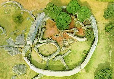
General description of the ruins
The extant ruins
of the city cover an area of seven square kilometers and are divided
into three areas: the 27-metre-high Hill Complex, also known as the Hill
Fort or Acropolis, the Valley Complex, and the elliptical enclosure, the
so-called Great Enclosure (also called the Temple ). The walls of
Greater Zimbabwe are built of granite blocks and without mortar. The
Great Wall has a base of five meters, a height of nine meters and a
total length of 244 meters. The dry stone walls even lack corner joints.
And, despite the name, they have never had roofs. They were stone
enclosures. In the courtyards thus enclosed stood huts and houses made
of mud and wood. Next to the four-meter-wide stairway to the Acropolis,
carved into the rock, the monoliths could have served astronomical
purposes.
mountain ruins
In the 19th century, visitors
repeatedly gave the mountain ruins the misleading name "Acropolis". At
first only the hill enclosure seems to have been named dzimbahwe. The
hill stretches 80 meters above the so-called Valley, on the south side
it is formed by a 30 meter high and 100 meter long cliff. The steepest
and shortest way to the top is the Cliff Ascent. On the high plateau to
the west is the eight meter high and five meter thick wall of the
western enclosure. Probably every two meters towers alternated with
stone columns on the top of the wall. The only two columns and the four
towers that exist today were reconstructed in 1916. The wall itself is
original, but part of the exterior had to be reconstructed due to
damage; the reconstruction is easy to see.
The original entrance
to the western enclosure is near the edge of the steep rock step and is
now walled up for safety. The current entrance is part of the wall
reconstruction of 1916. The western enclosure, the main living area on
the hill ruin, was continuously inhabited for 300 years. Remains of the
former huts covered the interior of the enclosure up to eight meters
deep. During safety work in 1915, a large part of it was thrown down the
rock face. Nevertheless, the original inspection horizons are still
visible in many areas. A similar "parallel passage" seems to have been
intended with the help of internal walls, as in the Great Enclosure in
the Valley. The southern wall stands directly on the cliff edge and was
decorated with columns. The northern and eastern walls are formed by
protruding rocks, over which the walls only had to be built by hand in
places, as the builders seem to have sought to involve nature in their
construction. In the north-east corner of the mountain plateau, the
so-called balcony is about ten meters above the enclosure. Various
columns made of granite and soapstone stood in this area until the end
of the 19th century, the largest of which was four meters high. One of
the Zimbabwe birds was recovered from the rubble in this balcony.
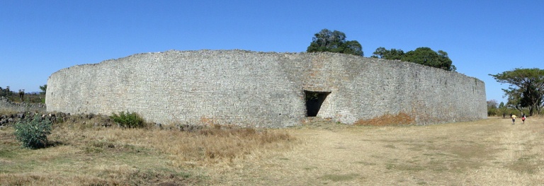
Large enclosure with parallel passage and conical tower
The Great
Enclosure was referred to as Imba Huru (Big House) by the locals in the
19th century. The current entrance through the Great Wall is a 1914
reconstruction placed in an inaccurate location. The wall is 255 meters
long and the weight of the million or so stones used is given as 15,000
tons. While the north-western part consists of relatively unornate
stones, the north-eastern part is expertly crafted, eleven meters high
and four meters thick at the top and up to six meters at the base. The
wall in the north-western area is of the poorest quality and is only
half as high and half as thick as in the other sections. Particularly
hard diorite was used to work the stones. The interior of the Great
Enclosure consists of several parts, starting with Enclosure #1, the
central area, the original outer wall, the conical tower and the narrow
tower, and the Dakha Platforms. Just north of the central area is
Enclosure #1, a simple circular wall and the earliest building in the
Great Enclosure. Inside were once huts of a household.
The so-called Parallel Passage connects to Enclosure No. 15 in the
north. It is formed from the present outer wall of the Great Enclosure
and the original outer wall built shortly after Enclosure #1. The inner
wall is about a century older than the outer. Archaeologist and former
curator of the site, Peter Garlake, theorized that the privacy of the
royal family, who lived behind the original wall, was at stake.
Privileged guests admitted into the enclosure surrounding the conical
tower could thus be admitted into the Great Enclosure and yet remain
outside the royal quarters. The passage is over 70 meters long and
almost everywhere only 0.8 meters wide. Between the passage and the
tower enclosure there are a series of platforms at different heights.
Until 1891 all entrances to the tower enclosure were blocked with
well-worked stones.
The conical stone tower is still ten meters
high today. Its diameter is five meters at the base and about two meters
at the top. Originally there was a three-line ornament on the upper
edge, which consisted of stones rotated by 45°, thus forming a series of
triangles in a zigzag pattern. For a long time it was assumed that there
was a secret treasury inside the tower. In 1929, the tower was partially
tunneled by archaeologists and it turned out to be solid and built
directly on the ground. The original construction and appearance of the
spire is unknown. Tower structures of unexplored function were also
built in Oman and Sardinia (Nuraghe), for example.
enclosures in
the valley
In addition to the Great Enclosure, there are a number of
smaller enclosures: Outspan Ruin, Camp Ruin, Hilltop Ruin, Ruin #1,
Posselt Ruin, Render Ruin, Mauch Ruin, Philips Ruin , the Maund Ruins
and the East Ruins.
finds
Six of the eight stone sculptures
were found in the eastern enclosure of the mountain ruins, which the
population apparently regarded as a sacred place. These Zimbabwe birds
are stone figures about 0.4 meters high that were placed on top of
pillars, reaching a height of one meter. Seven of the stone birds are
complete. Soft soapstone was used as the material. What is striking
about the birds is how unrealistic they are portrayed, for example how
thick the legs are or how bulky the body.
Some of the birds were
returned to Zimbabwe in 2003 after having been in Germany for almost 100
years. Today, the birds are a national symbol that is also found in the
state coat of arms and the national flag of Zimbabwe.
The first
bird was removed from the Philips ruins by Richard Hall in 1903. The
figure is 28 centimeters high, but measures 1.64 meters with the foot.
It is 23 centimeters deep and 6 centimeters thick. It is the most famous
of the eight birds, having become the model for depiction on the flag
and coat of arms of Zimbabwe.
The second bird is one of the
earliest artifacts removed from the ruins, having been taken from the
east wall of the hill ruins by Willi Posselt as early as 1889 and
probably sold to Cecil Rhodes. Because the bird was too big, Posselt
separated it from the column. The bird is 32 centimeters high with bent
legs and 12 centimeters wide at the thickest point. He is adorned with a
diamond patterned band around his neck.
The third, comparatively
roughly designed bird was removed from the east enclosure of the
mountain ruins by Bent. The figure is 43 centimeters high and 22
centimeters deep. The beak is broken off, but it appears to have been
the beak pointing farthest into the sky of all eight figures. The bird
stands on an implied wooden ring (like bird 7).
The fourth bird
was also removed by Bent from the eastern enclosure of the mountain
ruins. It measures 1.75 meters with the support column, and the bird is
only 34 centimeters high. At its thickest point it is 10 centimeters
wide. The eyes are marked by small humps. The tail is clearly spotted.
The fifth bird is also from the eastern enclosure of the hill ruins
and was removed by Bent in 1891. It is 1.73 meters high with the column,
the figure alone is 33 centimeters high and 9 centimeters wide. The beak
is also broken off, the eyes are knobbs, the wings are indicated but
smooth. Diamond patterns are indicated on the back. The tail is also
clearly spotted.
The sixth bird was also removed by Bent from the
eastern enclosure of the mountain ruins. It is 1.53 meters high with the
support column. The bird figure itself is 33 centimeters high and 10
centimeters wide. It has diamond patterns on its back similar to Birds 2
and 5.
From the seventh bird only the lower 20 centimeters are preserved. It
could have been the smallest of the eight figures and, like Bird 3,
stands on an indicated wooden ring. He was standing in the eastern
enclosure of the mountain ruins and was removed by Bent. The tail is
decorated with a herringbone pattern.
The broken specimen of the
eighth bird was removed from the mountain ruins by Richard Hall in 1902.
He is said to have stood on the so-called balcony, from which the
western enclosure of the mountain ruins can be overlooked. Hall found
only the top part of the figurine, sold it to Cecil Rhodes, who already
owned the bottom part. In 1906, the missionary Axenfeld brought the
figure to the Ethnological Museum in Berlin.
The Royal Treasure
A collection of objects referred to as royal hoards was found in
Enclosure No. 12 in the so-called Renders Ruins north of the Great
Enclosure in 1902 without observing or documenting the site or
stratigraphy. Around 100 kilograms of iron picks with traditional
patterns, but also narrow iron picks or adzes (adzes), axes and chisels.
Furthermore, an iron gong with narrow iron striking devices, two large
spearheads and over 20 kilograms of twisted wire. The find also
contained copper and bronze wires, some of which had already been
processed into jewellery. Another important find were tens of thousands
of small glass beads, probably from India, and 13th-century Chinese
pottery covered with celadon.
Other finds
Only a few finds
from the early excavations can be seen in the on-site museum. This
includes four bronze spears with separate blades, which seem very
impractical and were probably intended as a gift. Gongs and their batons
have also been preserved, as well as iron tongs, drawing boards and
molds used by the metalworkers in the Great Enclosure. Other finds
include Arabic coins and glassware. Finds discovered by early European
settlers in the hills surrounding the ruins include wooden bowls
decorated with crocodile patterns, as well as Ming Dynasty Chinese
pottery and Assam jewelry. It is not known with which Chinese fleets the
pottery reached the East African coast and from there on the trade
routes to Greater Zimbabwe.
political significance
The ruins
are a very important archeological site of southern Africa. Initially,
the evaluations were carried out by the Rhodesian Ancient Ruins Ltd.
aggravated, a commercial group of treasure hunters who had been granted
official digging rights. Subsequent excavations, particularly by R.N.
Hall, destroyed many traces of the Shona culture as the researchers, of
European origin, wanted to prove that the construction of ancient
Zimbabwe was not of black African origin. During British rule in
Rhodesia, as Zimbabwe was called until the black majority took power,
the indigenous African origin of the ruins was always disputed. In
addition to the Phoenicians, other exclusively light-skinned people (or
at least white men) were also referred to as founders.
In 1970,
archaeologists Roger Summers, National Museum employee (1947-1970), and
Peter Garlake (1934-2011), Rhodesian monument conservator (1964-1970),
left what was then Rhodesia because they wanted to continue working
under the white minority government of Ian Smith could no longer
reconcile with their scientific working methods. In 1978, Garlake became
Lecturer in Anthropology at University College, London University.
The ruins of Greater Zimbabwe have been featured on Zimbabwe's
national coat of arms since 1981.
Robert Mugabe cultivated a
personality cult based on African traditions and traced his origins back
to the kings of Greater Zimbabwe. That's why he was dubbed Our King.
Poems and hymns of praise, which had to be learned in schools,
celebrated his services to the country and his heroic deeds during the
war of liberation. He was also bestowed with numerous honorary titles
formerly borne by Shona kings.
One of the local ethnic groups,
more specifically the Lemba, has been linked to Semitic groups through
genetic comparisons.
infrastructure and tourism
Tourism development
The entire area
is managed by the National Museums and Monuments of Zimbabwe, with
Godfrey Mahachi as the site manager. The individual buildings are
accessible by paths and explained in several places by boards. A guest
house run by the national park administration and a campsite are
available to visitors. Despite the difficult political and economic
situation, the site continues to be visited by foreign guests.
However, after the country reform program in 2000, tourism in Zimbabwe
has been steadily declining. After increasing during the 1990s, with 1.4
million tourists in 1999, the number of visitors fell by 75 percent in
December 2000, less than 20 percent of the hotel rooms were occupied in
the same year. The total number of visitors for Zimbabwe in 2008 was
223,000 tourists. With the ruins of Greater Zimbabwe being the second
most visited main attraction in Zimbabwe after the Victoria Falls, this
has a particular impact on the local tourism industry. Local tourists
have been deterred from visiting by hyperinflation and a lack of basic
services, while foreign visitors have been discouraged by the unstable
political situation. With tourist visits falling by over 70 percent in
2001, more than 12,000 people lost their jobs. According to information
from the Federal Foreign Office, Zimbabwe has "almost completely lost
the former charm of a pleasant tourist and travel country with good
infrastructure."
By the year 2000, arriving visitors spent 2.5
hours touring the facility. The most visited spot was the Great
Enclosure, followed by the Gift Shop and then the Hill complex. Within
the Great Enclosure, the conical tower was the most frequently visited.
As a result of political developments in Zimbabwe, visitor numbers fell
from 120,000 in 1999 to 15,442 in 2008. For 2010, 30,000 visitors were
expected. List of paying visitors:
1980: 42,632
1981: 56,027
1989: 84,960
1990: 87,820
1991: 88,296
1992: 70,720
1993:
102,877
1994: 111,649
1995: 120,993
1996: 91,652
1997:
88,122
1998: 153,343
1999: 120,000
2006: 20,000
2007: 27,587
2008: 15,442
2010: about 30,000
2011: 49,323
2013: 55,170
2014: 58,180
2017: 61,000
2018: 72,284
2019: 45,359
2020:
11,952
Greater Zimbabwe receives operational funding from the US
government for the security forces and part of the museum. Further
funding is provided by the Culture Fund of the Swedish International
Development Cooperation Agency (SIDA) for the development of the site.
The National Public Investment Fund, which is based on a 50-50 rule, is
helping to build the infrastructure. Unesco occasionally provided funds
in the 1990s, for example for firefighting.
Museum Shona village
To the east of the ruins, a museum model of a 19th-century Shona village
was erected in 1986 as an additional attraction for tourists. However,
the representation of the components, the staff and the activities of
village life were described as not very authentic. In particular, the
use of modern tools in the demonstration of traditional crafts and the
modern clothing were criticized. Some researchers describe visitor
confusion and negatively assess the impact on the World Heritage site.
visitors to the ruins
The ruins have been the destination of
travelers ever since they were made famous by Mauch and Bent. Cecil
Rhodes visited the ruins as early as 1890. Queen Elizabeth II visited
the site twice, first on a three-month trip to South Africa in April
1947 with her father King George VI, her mother Elizabeth and her sister
Princess Margaret, and again in October 1991. On July 12, 1993, Princess
Diana visited Greater Zimbabwe and on May 20, 1997, Nelson Mandela.
transport connection
There are many local bus services between
the ruins and the bus terminal in Masvingo. From the ruin site there are
also direct bus connections (coaches) to Bulawayo or Harare. The nearest
international airports are Harare Airport to the north and Johannesburg
Airport to the south.
Miscellaneous
The ruins featured on the
Z$50 bill from the introduction of Zimbabwe's currency notes after
independence in 1980 until the currency was suspended in 2008, but which
has hardly been used since 2000 due to hyperinflation. One of the
Zimbabwe birds was the motif on the 1 cent coin.
Furthermore, a Z$1
stamp was issued on the occasion of the inclusion of the ruins in the
World Heritage List in 1986, on which the Great Enclosure is depicted.
Another stamp, this time featuring the conical tower and the bird of
Zimbabwe, was issued in 2005.