Azas Nature Reserve is a state natural reserve located in the Todzha kozhuun of the Tuva Republic. It was created on January 11, 1985 on the basis of the Azas republican reserve. It is a member of the association of nature reserves and national parks of the Altai-Sayan ecoregion.
The territory of the
reserve (300 390 hectares within the boundaries of 1991) is located
in the central part of the Todzha depression in the north-east of
Tuva and stretches in a latitudinal direction along the river. Azas.
The geographical coordinates of its extreme points: north - 52 ° 42
', south - 52 ° 16', east - 98 ° 42 ', west - 96 ° 30'. The eastern
border runs along the administrative border with the Republic of
Buryatia. A two-kilometer protective zone with a total area of 90
thousand km² has been created around the reserve.
The Todzha
basin is a huge intermontane depression within the Altai-Sayan
mountainous country. This is a unique drainage basin that feeds the
headwaters of the largest river in Siberia - the Yenisei. Its
colossal hydro resources are enclosed in a dense river network and
numerous lakes.
The climate of the Todzha
depression is sharply continental and moderately humid. The low
mountainous framing of the basin in the west and northwest, in
places dropping to 1300 m (Amyl pass), does not impede the northwest
winds carrying humid Atlantic air. Additional moisture is created by
local precipitation due to abundant evaporation from lakes and
swamps. The influence of high-altitude zones on the climate is
great.
According to the long-term average data of the
Toora-Khem meteorological station, which characterizes the low
mountains of the reserve, the minimum temperature in January reaches
-54 ° C. The average daily temperature in January is -28.7 C °, in
July - +14.6 C °. The annual temperature is -5.5 C °. Summer is
cool, summer frosts are not uncommon. The frost-free period lasts 52
days. The sum of the average daily temperatures above 10 C ° is
10.94 C °, the average annual precipitation is 343 mm, 60% of which
falls in summer. The middle and high mountains are characterized by
a softer continentality and an increase in precipitation up to
600-800 mm.
Phenological winter in low mountains, begins at
the end of October, at the beginning of November a permanent snow
cover is established. The height of the snow in January-February
reaches 25-30 cm, in the middle mountains - up to 80 cm and more.
The stable snow cover lasts 162 days on average and collapses at the
end of March. Snow melting ends by mid-April, in the middle
mountains - by the end of May, in the highlands it stretches until
mid-July.
Vegetation in low-mountain landscapes begins on
average on April 24. In mid-May, during the green spring stage,
trees and shrubs are leafing. The final stage of spring - pre-summer
is marked by the blooming of bird cherry in the end of May along the
river valleys, most of the berries bloom. Summer is short - no more
than two months. Its sign is the blooming of wild rose in the second
half of June, and already in mid-August the forest is replete with
yellow strands of birches, marking the beginning of a golden autumn.
By the end of the first decade of September, deciduous trees and
shrubs are fully blooming. The growing season ends on September 10.
From mid-September, daily temperatures become less than +5 C °,
regular frosts occur, larch quickly turns yellow, forming a
deep-autumn landscape. In the first half of October, with the end of
the larch needles falling off, pre-winter sets in, the landscape
becomes gray and almost silent.
In the highlands, spring and
summer are very compressed; the background of summer minimum
temperatures does not exceed 3 ° C. Frosts are likely at any time.
Vegetation begins in mid-June, and already in the first decade of
August, the round-leaved birch (yernik) turns yellow and the
mountain meadows wither, indicating the beginning of autumn.
In terms of hypsometric position, climate and vegetation,
the Todzha depression is of a mid-mountainous character. The bottom
of the basin rises from west to east from 850 to 2000 meters above
sea level. The basin is framed by highlands with heights of
2300-2900 m, belonging to three mountain systems. In the south, the
mountain ranges of the Academician Obruchev ridge rise, in the west
and north-west - the Western Sayan, in the north-east and east - the
Eastern Sayan. One of the highest points of the Eastern Sayan -
Topografov peak (3044 m) is located near the eastern border of the
reserve, passing along the watershed of the Big Sayan ridge. The
highest mountain peak of the reserve is confined to the watershed -
2912 m.
The reserve is completely located in the area of
the former cover glaciation, which created picturesque relief
forms. All mountain rises in its territory belong to the system of
the Biy-Khem plateau. The high-mountain ridge Ulug-Arga (2200-2400
m), borders the left bank of the Azas River in the upper reaches. To
the east of it stretches the Sai-Taiga volcanic plateau, gradually
turning into the Bolshoi Sayan ridge. The plateau feeds numerous
sources of the Azas, Sorug and Biy-Khem rivers. Table
mountains-volcanoes rise above the plateau: Shivit-Taiga - 2769 m,
Kok-Khemsky - 2701 m, Sorug-Chushku-Uzyu massif - 2517 m. Their
slopes are processed by a glacier. Penalties, trogs, mountain ridges
are pronounced. Lakes are common in carats. The volcanic plateau and
the Ulug-Arga ridge are characterized by an alpine alpine relief
type with the participation of alpine forms. The slopes facing the
river valleys have a sharp glacial erosional dissection.
To the west, the Ulug-Arga ridge goes down and passes into the
low (1600-1900 m) Kadyr-Egi-taiga ridge, which is the watershed of
the Azas and Bash-Khem rivers. The relief is medium-mountainous
erosional.
A special place is occupied by the interfluve of
the Azas, Khamsara and Sorug rivers. In the upper and middle reaches
of the Azas River, it is a mid-mountain ridge-hilly plain with
heights of 1300-1800 m. Examination glacial landforms prevail:
ridges and hills extended along the movement of the glacier, trough
valleys, exaration scarps. Moraine deposits are developed in the
depressions. In the lower reaches of the river. On the Azas
interfluve, glacier-accumulative formations are widespread: outwash
terraces, end-moraine ridges, ozes, kams, etc. The relief is
low-mountain hilly-moraine with heights of 950-1300 m. There are
numerous lakes and raised bogs. The largest lakes of the reserve are
located here.
The entire hydrological
network of the Todzha depression belongs to the basin of the Bolshoi
Yenisei (Biy-Khem) River. Two large rivers flow through the reserve:
in the central part - Azas, and along the northeastern border -
Sorug, which is the left tributary of the river. Hamsara. In the
southern part of the reserve, mountain rivers and streams flow into
the river. Bash-khem, enveloping its security zone. On the spurs of
the ridge. Big Sayan in the reserve begins the main source of
Biy-Khem - r. Kok-Khem. The main waterway is r. Azas originates on
the Sai-Taiga mountain plateau and flows into the flowing lake Azas.
The length of the river from the confluence of the sources to the
mouth is 155 km, the height difference is 800 m. In the upper
reaches of the river below the mouth of the river. Khaaktyg-Khem is
the picturesque Azass waterfall and rocky canyon.
There are
30 large and medium and over 100 small lakes on the territory of the
reserve. They are predominantly of glacial origin and occupy ancient
flow valleys stretching from west to east along the movement of the
glacier. The largest lakes are Many-Khol (3070 ha) and Kadysh (2580
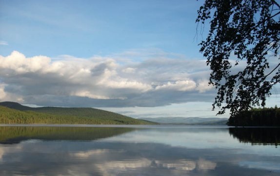
ha). One of the largest and most famous lakes of the Todzha
depression - Azas or Todzha (5470 hectares) is part of the reserve.
In the upper reaches of the river. Biche-Sorug has a group of
cold mineral springs of carbon dioxide character. Before the
formation of the reserve, the springs were used for medicinal
purposes. They are readily visited by ungulates.
The
soil cover of the reserve is poorly studied. The mountainous tundra
soddy-humus and peaty-humus soils prevail in the alpine zone.
Primitive and mountain meadow soils are widespread.
In the
upper part of the forest belt, the most common varieties of mountain
taiga humus sour and peaty-podzolic soils, developing under the
blueberry-green moss cedar taiga and subalpine woodlands.
In
the middle lane, mountain-taiga soddy-weakly podzolic and
peaty-humus soils are formed under the lingonberry-green moss cedar
and larch taiga.
In the lower part of the belt, where grasses
and rich forbs appear in the grass cover, varieties of mountain
soddy soils are more characteristic. Under the birch-larch forests
there are also gray forest and meadow-chernozem soils. In the entire
altitudinal interval of the forest belt, in depressions, the lower
parts of the northern slopes, lake and river terraces, and stream
valleys, taiga-permafrost peaty-humus gley and peat bog soils are
very common. In the conditions of meadow-steppe vegetation,
varieties of mountain chernozems and meadow-chernozem soils are
common.
There are two main vertical belts on
the territory of the reserve: forest and alpine. In the low
mountains, the steppe belt is fragmentarily expressed. Forest areas
occupy 73%, mountain tundra and loach placers - 16%. The rest of the
areas are swamps, meadows, steppes, and reservoirs.
The
reserve presents the most humid type of vertical zonation of the
vegetation cover of the mountain systems of Tuva - the East Sayan or
Todzha, which characterizes the Todzha cedar-larch district of the
East Sayan mountain taiga province. In the forest belt, there is a
clear change with height from subtaiga herbaceous larch and birch
forests (900-1100 m above sea level) to mountain-taiga larch, cedar,
mainly moss forests (1000-1700 m) and then subalpine cedar,
cedar-larch forests and woodlands (1700-1900 m). Mountain taiga
forests absolutely prevail in area. The alpine belt (1900-2600 m) is
mountain-tundra in terms of the nature of the landscape, with the
inclusion of subalpine and alpine vegetation. The peculiarities of
the vegetation cover, caused by glacial landforms, include the wide
distribution of shrubby vegetation on fluvioglacial river terraces,
pine forests on moraine deposits, in combination with permafrost
processes - swamps and swampy woodlands. A characteristic element
for all altitudinal belts is rocks and stony placers with pioneer
groups of plants, which are especially widely represented in the
highlands.
The flora of the higher vascular includes 925 species belonging
to 355 genera and 93 families. The leading place belongs to the
families Zlakovye - 96, Astrovye - 92, Sedge - 77 species. The
reserve is home to 7 species of plants from the Red Data Book of the
RSFSR (1988): feather grass, hazel grouse Dagan, wrestler Pascoe,
lady's slipper, large-flowered lady's slipper, leafless caper,
neottiante nodule. The flora includes about 40 regionally rare
species, some of which are included in the Red Data Book of the Tyva
Republic: plants (1999): quadrangular water lily, pure white water
lily, small egg capsule, etc. In total, 13 species are objects of
the Red Data Books of the Russian Federation and the Republic of
Tatarstan.
The list of bryophytes of 217 species includes 70
species of hepatic and 147 leafy mosses. Among leafy mosses, species
new to science have been described: Didimodon hedysariformis T.
Otn., Orthotrichum furcatum T. Otn. 11 species of leafy mosses are
rare for Siberia.
The reserve has 133 species of lichens,
including 8 rare for Siberia. The group of epilithic lichens has not
been studied. The inventory is ongoing.
The
study of invertebrate fauna is in its early stages. The ichthyofauna
includes 15 species, among which the most rare is taimen (Hucho
taimen), listed in the Red Book of the Tyva Republic (2002). There
are 2 species of amphibians - the Siberian salamander (Hynobius
keyserlingi) and the sharp-faced frog (Rana arvalis). Reptiles are
represented by 3 species: the viviparous lizard (Lacerta vivipara),
the Pallas mouton (Agkistrodon halys) and the common viper (Vipera
berus) - a species of the Red Book of the Republic of Tatarstan.
The general list of avifauna on the territory of the reserve
includes 230 species, of which 138 are nesting ones (Current state
... 2003), and taking into account the buffer zone, 254 species. The
most richly represented are the orders of passerine,
charadriiformes, falconiformes and anseriformes. 20 rare bird
species are listed in the Red Book of the Tyva Republic (2002), of
which 10 are included in the Red Book of the Russian Federation
(2001). The white-tailed eagle (Haliaeetus albicilla), a species of
the IUCN Red List, an osprey (Pandion haliaetus), an eagle owl (Bubo
bubo), a taiga bean goose (Anser fabalis middendorffii) and a
mountain snipe (Gallinago solitaria), find optimal conditions for
nesting in the reserve.
The reserve is home to 51 species of
mammals: insectivores - 10, bats - 2, lagomorphs - 2, rodents - 17,
carnivores - 13, artiodactyls - 7 species. The list contains 3
species of the Red Data Books of the Russian Federation and the
Republic of Tatarstan: Tuvan beaver (Castor fiber tuvinicus), snow
leopard (Uncia uncia) and forest reindeer (Rangifer tarandus
fennicus), another species is included in the Red Data Book of the
Republic of Tatarstan: otter (Lutra lutra). Tuvinian beaver is
endemic to Tuva, the main population is located on the Azas River
under the protection of the reserve. During the existence of the
reserve and then the Azas reserve, its number increased more than 3
times and stabilized by the 1990s at the level of 70-80 individuals
in 19-22 settlements.
In 2003-2004, 17 beavers were resettled
from the r. Azas on the r. Belin (Kaa-Khem region). After
resettlement, the number of beavers on the river. Azas is 45-46
beavers in 13 settlements with the prospect of restoration to the
previous one.