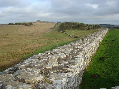
Hadrian's Wall is an ancient Roman series of defenses that run across the United Kingdom.
Location: the wall roughly runs along highways A69 and B6318 Map
Constructed: started in AD 122 by emperor Hadrian
The Wall or Hadrian's Wall is an old defensive construction of
the island of Britania , built between 122 - 132 by order of the
Roman emperor Hadrian to defend the British territory submitted,
south of the wall, to the warlike tribes of the Picts which extended
further north of the wall, in what would later become Scotland after
the invasion of the shafts from Ireland . The wall also had the
function of maintaining economic stability and creating peace
conditions in the Roman province of Britanniasouth of the wall, as
well as physically marking the border of the Roman Empire . Today
important sections of the wall still remain, while other sections
have disappeared as their stones have been reused in neighboring
buildings for centuries.
This fortified limes extended for 117 km from the Gulf of Solway in
the west to the estuary of the Tyne River in the east, between the
towns of Pons Aelius (now Newcastle upon Tyne ) and Maglona ( Wigton
). 1The wall itself was built entirely with stone blocks, it was 2.4
to 3 meters thick and 3.6 to 4.8 meters high. It had 14 main forts
and 80 forts that housed garrisons at key surveillance points, as
well as a pit in its northern part of 10 m and a military road that
ran along its southern side. Further south of the military road they
built another moat with two earth embankments to protect the wall
from attacks from the south. Its name is sometimes used as a synonym
for the border between Scotland and England , although the wall
follows a line farther south than the modern border.
Its defensive function was subsequently assumed by the wall of
Antonino Pio , raised further north and abandoned after a brief
period before the hostility of the Caledonian tribes, making the
wall of Hadrian again the northern limit of the Roman territory of
Britain. The Picts crossed the wall three times, in 197 , 296 and
367 . It was repaired and enlarged in 209 , during the reign of
Septimius Severus , and finally abandoned in 383 . After their
abandonment, the inhabitants of the region reused many stones from
the wall to build farms, churches and other buildings.
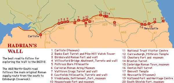
Hadrian's Wall was constructed started in AD 122 by emperor Hadrian to defend south part of the island known at the time as a Roman province of Britannia against attacks by barbarian tribes from the North. The wall roughly runs along highways A69 and B6318. There over 16 large forts along its length, along with 80 smaller fortifications and 158 turrets to keep an eye over dangerous frontier.
Banks East Turret Pike Hill Watch (Signal) Tower
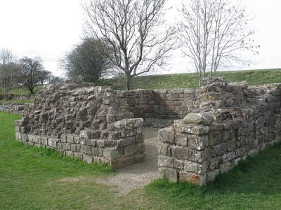
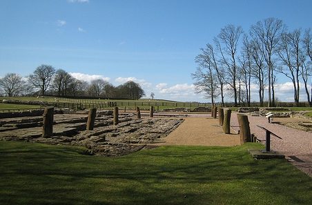
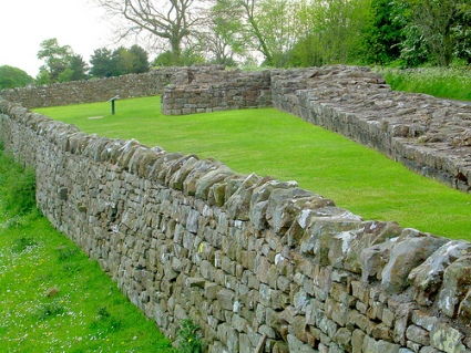
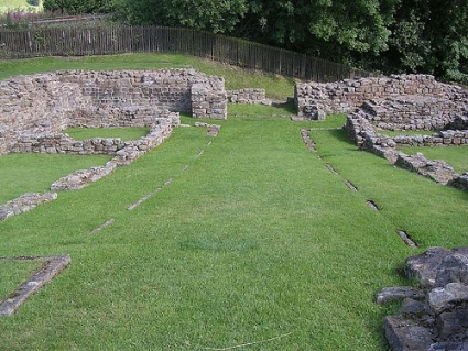
Chesters Fort (Cilurvum or Cilurnum)
Location: Map
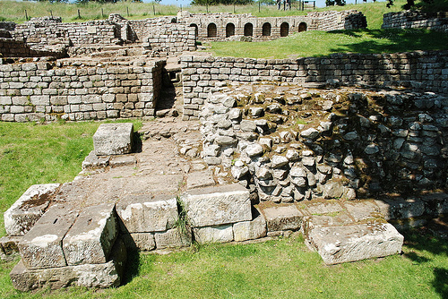
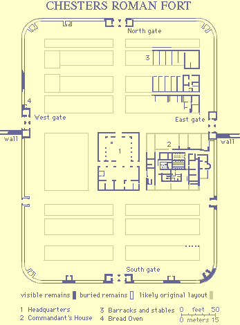 Cilurvum or Cilurnum
is one of the best preserved forts along a Hadrian's Wall that was
mentioned in Notitia
Dignitatum, documentation of Roman
imperial chanceries. It is located near a town of Chester also
known as Walwick Chesters in the Northumberland
County of United Kingdom. It was constructed in 123 AD as a cavalry fort
intended to strengthen presence in the region. It was known as
ala Augusta ob virtutem appellata
("named Augusta because of its valour"). Any attack from a North would
result in retaliation attacks from a Roman cavalry deep into enemy
territory. Later contingent was strengthened by infantry units of First
Cohor of Vangiones from the Upper Rhineland in German province and First
Cohor of Dalmations from present day Serbia, Croatia, Bosnia and
Herzegovina. Among old barracks you find an altar of a "Cult of
Disciplina", that was actively encouraged by the emperor Hadrian
himself. Archeological digs continue for decades and still there is a
lot of work to be done. Numerous findings from a site are presented in
the museum of the site.
Cilurvum or Cilurnum
is one of the best preserved forts along a Hadrian's Wall that was
mentioned in Notitia
Dignitatum, documentation of Roman
imperial chanceries. It is located near a town of Chester also
known as Walwick Chesters in the Northumberland
County of United Kingdom. It was constructed in 123 AD as a cavalry fort
intended to strengthen presence in the region. It was known as
ala Augusta ob virtutem appellata
("named Augusta because of its valour"). Any attack from a North would
result in retaliation attacks from a Roman cavalry deep into enemy
territory. Later contingent was strengthened by infantry units of First
Cohor of Vangiones from the Upper Rhineland in German province and First
Cohor of Dalmations from present day Serbia, Croatia, Bosnia and
Herzegovina. Among old barracks you find an altar of a "Cult of
Disciplina", that was actively encouraged by the emperor Hadrian
himself. Archeological digs continue for decades and still there is a
lot of work to be done. Numerous findings from a site are presented in
the museum of the site.
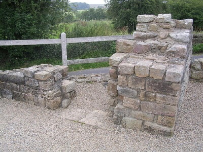
Chesters Bridge
Location: Map
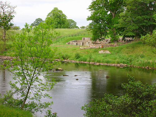
Chesters Bridge is an ancient Roman bridge that was constructed near Chesters Fort to ease movement of Roman infantry and cavalry. The first bridge was erected on this spot across River North Tyne river in 122- 24 AD. A second bridge was constructed here in the early 3rd century AD, apparently after a flood that destroyed the first bridge. It was larger and more substantial measuring at a length of 189 feet (57.6 m) and a width of 10 feet (3 m) wide. The bridge was also destroyed by waters of river North Tyne that changed its coarse. Western base was destroyed, by eastern base of the bridge is well preserved. It gives an idea of the great masonry work done by the Roman army engineers.
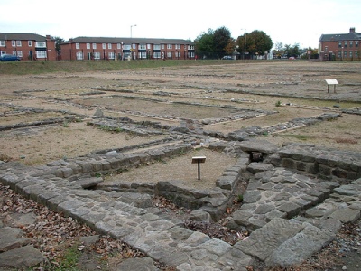
Carvoran (Magnis)
Location: Map
Carvoran Roman Fort known as a Magnis was constructed here on the crossroads of ancient Roman roads. It was probably constructed before the Hadrian's wall and was later incorporated into military defences.
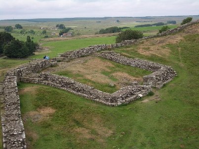
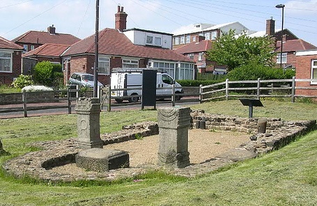
Carrawburgh
Location: Map

Carrawburgh is an ancient Roman Fort in Northumberland County of UK. In the ancient times it was known asBrocolitia, Procolita, or Brocolita. Among its living quators you can find several temples of the pagan dieties. Especially famous is that of God Mithras pictured above on the left.
Vindolanda
Location: Map
Vindolanda is an ancient Roman fort constructed here to guard an ancient Roman road known as Stanegate. It is situated near a village of Bardon Mill in Northumberland County. Judging by the inscriptions in Ancient Latin this fort was inhabited by the troops from Gaul or modern day France. The fort was abandoned in the early 5th century AD.
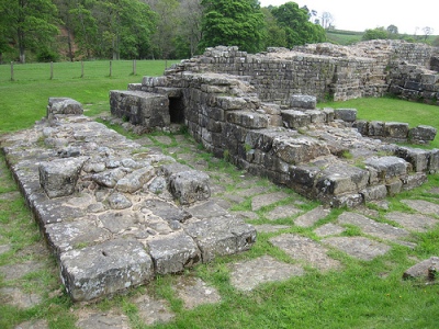
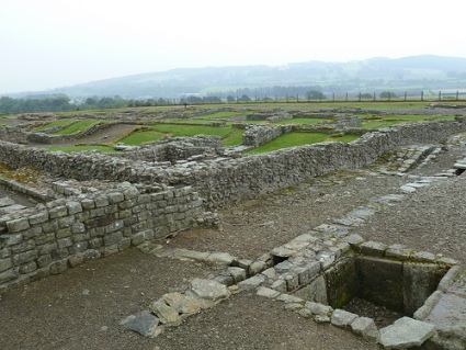
Housesteads Roman Fort (Vercovicium)
Location: Map
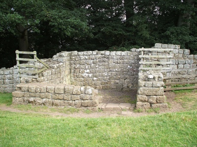
Poltross Milecastle 48
Location: village of Gilsland, Cumbria Map
Corbridge (Coria) Roman Town
Location: Northumberland Map
Arbeia or South Shields Fort
/133697522_69fdc4639f[1].jpg)
|
Birdoswald Roman Fort Location: Cumbria Map
|
Willowford Wall, Bridge Abutment, Turret
|
|
Cawfields Milecastle 42
|
Brunton Turret
|
|
Benwell Temple (Antenociticus)
|
Segedunum or Wallsend Fort Location: Wallsend, Tyne and Wear Map
|