Location: Yukon Map
Area: 22,013 km2
Contact the Kluane National Parkoffice at +1-867-634-7250 ext 216,
or email: kluane.info@pc.gc.ca
Kluane National Park is located
in Yukon Territory of Canada and covers a total area of 22,013 km2
(8,499 sq miles). Kluane National Park was proclaimed as UNESCO
World Heritage Site in 1979 for its unique landscape shaped by
glacial activity and abundant wild life. Fauna of Kluane National
Park deserves few words. It is abundant. Caribou, moose, squirrels,
bald eagle and snowshoe hare are just the few that you can encounter
here. Additionally you can encounter less welcome guests like
Canadian Lynx, grizzly bear and packs of wolves. Although the last
rarely attack people unless they are forced by hunger and winter,
the first two can easily charge you. It is especially true if you
startle them unexpectedly. So the best way to avoid close contact is
to travel in groups or bring something that rattles.
There
is plenty of opportunities for hiking in Kluane National Park.
Kluane National Park has a network of several trails that include
Alsek Tral, Auriol Trail, Saint Elias Lake Trail, Mush Lake Road,
Rock Glacier trail, Sheep Creek Trail, Bullion Plateau Trail,
Dezadeash River Trail and many other. Some people avoid these man
made roads and take it back country camping. You take minimum amount
of food since you can also fish here for several species of trout,
northern pike, sockeye salmon and several other species.
Fishing per permit:
Daily $
9.80
Annual $ 34.30
Parks Canada Passes
The Discovery Pass provides unlimited admission for a full year
at over 80 Parks Canada places that typically charge a daily
entrance fee It provides faster entry and is valid for 12 months
from date of purchase. Prices for 2018 (taxes included):
Family/group (up to 7 people in a vehicle): $136.40
Children and
youth (0-17): free
Adult (18-64): $67.70
Senior (65+): $57.90
The
Cultural Access Pass: people who have received their Canadian
citizenship in the past year can qualify for free entry to some
sites.
The park was inhabited by the Southern Tutchone Indian tribes for
more than 10,000 years. Indian culture is closely intertwined with the
natural features of the region. From generation to generation, oral
tradition passes on information about seasonal temperature fluctuations,
changes in animal numbers, and methods of adaptation. The southern
Tutchone engaged in trade with the coastal Tlingit, which only
intensified with the arrival of Europeans. In 1903, there was a small
gold rush in the park due to the discovery of gold in Sheep Creek and
Bullion Creek.
The idea for the park arose after the construction
of the Alaska Highway through the region in 1942. In 1943, a wildlife
reserve was created in the area, and local communities were evicted from
its boundaries. In 1972, work on the creation of a national park and
reservation was completed, which included the inclusion of Indian
settlements. In 1995, an agreement was signed with the communities of
Champaign and Eishihik, and in 2004, an agreement was signed with the
community of Kluane. Currently, Indian communities are involved in the
management of the park.
The name of the park comes from the name
of Lake Kluane, which is the largest lake in the Yukon. There are a lot
of fish in the lake, which is reflected in the name. Kluane, which
should be pronounced kluoni, means a lake where there are many fish.
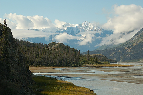
The park is home to Canada's tallest and most massive mountains,
including Mount Logan, the country's highest peak. About half of the
park's area is occupied by glaciers, being the largest accumulation of
ice outside the polar zones.
Due to its significant size,
elevation changes and proximity to the ocean, the climate in the park is
very diverse. Much of the park has a continental climate due to the
Saint Elias Mountains. The southern part of the park, exposed to ocean
influences, typically experiences greater temperatures and
precipitation.
The park protects the Northern Coastal Mountains Natural Region, the
Arctic Cordillera ecozone and the Pacific coast.
The park's flora
is represented by species characteristic of the ocean coast, western
mountains, northern prairies and steppes. The mountain slopes and low
valleys are covered with forests including white spruce, aspen, and
Indian balsam poplar. The forests end at a level of 1050-1200 meters,
above which only willow, alder and dwarf birch can be found. At a level
above 1400 meters, the alpine tundra, represented by more than 200
species, begins. Flowering summer meadows are represented by Arctic
poppy, saxifrage, mountain heather and stemless gum.
The park is
home to a large number of mammals, including sheep, mountain goats,
caribou, grizzly bears, black bears, wolves, wolverines, muskrats,
minks, marmots, lynxes, coyotes, beavers, etc. In addition, there are
more than 150 species of birds.
Mountain biking is possible on some trails and the park is a paradise for hikers, for whom there are trails and routes of varying lengths and difficulty. Paths are mostly laid out, well marked, some have bridges, they are relatively easy to follow and some have primitive campsites. Routes indicate a rough hiking direction and demand significantly more from the hiker due to the height differences and river crossings.
St. Elias Lake; Length: 3.8km, Elevation Gain: 120m, Maximum
Elevation: 880m, Difficulty: Easy, Duration: 2 to 4 hours, Starting
point: 60km south of Haines Junction on Haines Road
Mush Lake Road;
Length: 22 km, Elevation gain: 30 m, Maximum altitude: 760 m, Difficulty
level: easy, Duration: 1 to 2 days, Starting point: 55 km south of
Haines Junction on Haines Road, mountain bikes allowed
Shorty Creek;
Length: 12km, Elevation Gain: 270m, Maximum Elevation: 1,000m,
Difficulty: Average, Duration: 6 to 9 hours, Starting point: 55km south
of Haines Junction on Haines Road
Cottonwood; Length: 83 km,
Elevation difference: 520 m, Maximum altitude: 1,310 m, Difficulty:
difficult, Duration: 4 to 6 days, Starting point: 27 or 55 km south of
Haines Junction on Haines Road, circular route, mountain bikes partially
permitted
Rock Glacier; Length: 600 m, Elevation gain: 90 m, Maximum
altitude: 790 m, Difficulty: easy, Duration: 0.5 to 2 hours, Starting
point: 45 km south of Haines Junction on Haines Road
kokanee; Length:
300 m, Elevation Gain: 120 m, Maximum Elevation: 3 m, Difficulty: Easy,
Duration: 10 to 30 minutes, Starting Point: Kathleen Lake Day Use Area,
27 km south of Haines Junction on Haines Road
Auriole; Length: 15 km,
Elevation gain: 400 m, Maximum altitude: 1,160 m, Difficulty: average,
Duration: 4 to 6 hours, Starting point: 7 km south of Haines Junction on
Haines Road, circular route
Dezadeash River; Length: 4.8 km,
Elevation Gain: 15 m, Maximum Elevation: 640 m, Difficulty: Easy,
Duration: 1 to 2 hours, Starting point: Haines Junction Visitors Center
or at the bridge over the Dezadeash River, circular route
Alsek;
Length: 26 km, Elevation gain: 90 m, Maximum altitude: 610 m, Difficulty
level: easy, Duration: 1 to 3 days, Starting point: 10 km north of
Haines Junction on the Alaska Highway, mountain bikes allowed
Bullion
Creek; Length: 5.8 km, Elevation Gain: 150 m, Maximum Elevation: 940 m,
Difficulty: Easy, Duration: 4 to 6 hours, Starting point: Sheep Mountain
Information Center, 72 km north of Haines Junction on the Alaska
Highway, mountain bikes allowed
Sheep Bullion Plateau; Length: 12 km,
Elevation Gain: 880 m, Maximum Elevation: 1,620 m, Difficulty: Average,
Duration: 6.5 to 8 hours, Starting point: Sheep Mountain Information
Center, 72 km north of Haines Junction on the Alaska Highway
Sheep
Creek; Length: 3.8 km, Elevation Gain: 430 m, Maximum Elevation: 1,280
m, Difficulty: Average, Duration: 3 to 6 hours, Starting point: Sheep
Mountain Information Center, 72 km north of Haines Junction on the
Alaska Highway.
Soldiers Summit; Length: 0.5 km, Elevation Gain: 90
m, Maximum Elevation: 880 m, Difficulty: Easy, Duration: 20 to 90
minutes, Starting point: 1 km north of Sheep Mountain Information
Center, 73 km north of Haines Junction on the Alaska Highway
Onion Lake; Length: 35 km, Elevation difference: 830 m, Maximum
altitude: 1,380 m, Difficulty level: for experienced hikers, Duration: 3
to 5 days, Starting point: Dalton Post, 84 km south of Haines Junction
on Haines Road, mountain bikes partially permitted
Goatherd; Length:
60 km, Elevation difference: 640 m, Maximum altitude: 1,190 m,
Difficulty level: for experienced hikers, Duration: 7 to 11 days,
Starting point: 55 km south of Haines Junction on Haines Road, mountain
bikes partially permitted
King's Throne; Length: 5 km, Elevation
Gain: 1,220 m, Maximum Elevation: 1,980 m, Difficulty: for experienced
hikers, Duration: 4 to 10 hours, Starting point: Kathleen Lake Day Use
Area, 27 km south of Haines Junction on Haines Road
Quill Creek
South; Length: 18 km, Elevation Gain: 730 m, Maximum Elevation: 1,580 m,
Difficulty: Difficult, Duration: 2 to 4 days, Starting point: 13 km
north of Haines Junction on Haines Road
Mt Decoeli; Length: 9 km,
Elevation Gain: 1,340 m, Maximum Elevation: 2,330 m, Difficulty: for
experienced hikers, Duration: 7 to 11 hours, Starting point: 25 km north
of Haines Junction on the Alaska Highway
Kimberly Meadow; Length: 62
km, Elevation gain: 1,219 m, Maximum altitude: 1,890 m, Difficulty: for
experienced hikers, Duration: 3 to 5 days, Starting point: 25 km north
of Haines Junction on Haines Road, circular route
Slims East; Length:
23 km, Elevation Gain: 910 m, Maximum Elevation: 1,680 m, Difficulty:
Difficult, Duration: 2 to 4 days, Starting point: 3 km south of Sheep
Mountain Information Center, 69 km north of Haines Junction on the
Alaska Highway, mountain bikes allowed
Volcano Creek; Length: 10 km,
Elevation Gain: 790 m, Maximum Elevation: 1,580 m, Difficulty: for
experienced hikers, Duration: 1 to 2 days, Starting point: 3 km south of
Sheep Mountain Information Center, 69 km north of Haines Junction on the
Alaska Highway
Kluane Plateau; Length: 7 km, Elevation Gain: 975 m,
Maximum Elevation: 1,770 m, Difficulty: for experienced hikers,
Duration: 7 to 11 hours, Starting point: 3 km south of Sheep Mountain
Information Center, 69 km north of Haines Junction on the Alaska Highway
Slim's West; Length: 30 km, Elevation difference: 910 m, Maximum
altitude: 2,114 m, Difficulty level: difficult, Duration: 3 to 5 days,
Starting point: Sheep Mountain Information Center, 72 km north of Haines
Junction on the Alaska Highway, mountain bikes allowed in parts
Sheep
Mountain Ridge; Length: 11 km, Elevation Gain: 1,310 m, Maximum
Elevation: 1,920 m, Difficulty: Difficult, Duration: 6 to 10 hours,
Starting point: 2 km north of Sheep Mountain Information Center, 74 km
north of Haines Junction on the Alaska Highway, loop trail
Sheep
Congdon; Length: 25 km, Elevation gain: 910 m, Maximum elevation: 1,710
m, Difficulty: average, Duration: 2 to 3 days, Starting point: Sheep
Mountain Information Center, 72 km north of Haines Junction on the
Alaska Highway, loop trail
Williscroft Canyon; Length: 2 km,
Elevation Gain: 240 m, Maximum Elevation: 1,040 m, Difficulty: Average,
Duration: 1.5 to 3 hours, Starting point: 9 km north of Sheep Mountain
Information Center, 81 km north of Haines Junction on the Alaska Highway
Donjek; Length: 96 km, Elevation gain: 2,700 m, Maximum altitude: 2,070
m, Difficulty: for experienced hikers, Duration: 6 to 10 days, Starting
point: Duke River, 9 km north of Burwash Landing Center, 81 km north of
Haines Junction on the Alaska Highway, loop route
The national park and national park reserve are administered
according to a co-management model between Parks Canada, the Champagne
and Aishihik First Nations and the Kluane First Nation, where the
parties share the administration of the natural and cultural resources
of the park within the Kluane National Park Management Board. These two
indigenous entities are of Southern Tutchone ethnicity, the people
inhabiting the territory where the national park is located since time
immemorial.
A particularity of the park lies in its bilingual
road signs where the signs located within the boundaries of the park,
namely on the Haines Highway, the Alaska Highway and the Klondike
Highway, include indications in English and Tutchone. from South.