Location: 31 mi (50 km) from Cusco Map
Open: 7:30am- 5pm daily
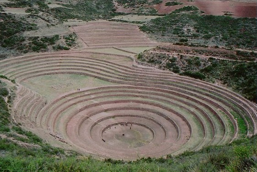
Moray and Salinas de Maras is an ancient archaeological site in Peru that is situated 50 km (31 mi) North- West of Cusco. It was constructed by Inca natives, presumably as a giant agricultural experiment station. Moray and Salinas de Maras is situated on a high plateau situated 3500 meters (11500 feet) above sea level. The closest nearby settlement is Maras village that also gives the name to the whole structure. It consists of giant circular terraces that were used to cultivate traditional plants. This well like fields reach a depth of 30 meters or 98 feet. Moray and Salinas de Marinas has sophisticated irrigational system and several ruins indicating large important settlement nearby. Many historians suggested that this site might have been ancient laboratory intended to experiment with various crops. The difference between various levels of terraces reaches 15 degrees Celsius or 27 degrees F. This dramatic difference was achieved by natural movement of winds and sun ray angle at which it falls on the ground.
Recent flash floods created land slides that caused great degree damage to Moray and Salinas de Maras archaeological site. Despite attempts of administration to fix the problem and prevent further damage, lack of funds greatly undermines the progress of restoration.
Location
The archaeological remains of Moray are located 7 km from
Maras, in the Sacred Valley of the Incas and 38 km northwest of Cuzco.
It is possible to get to Moray through the road that starts from the
town or directly from a detour from the main road. Moray is a Quechua
word and names a sector occupied by the peasant communities of Misminay
and Kaccllarakay.
Climate
The archaeological site of Moray is
located on a plain at an altitude of 3,500 meters above sea level, and
is surrounded by mountains, which is why the climate that is created is
temperate and dry at the same time. Perfect for agriculture. But the
archaeological site due to the type of architecture has different
microclimates, therefore, it was optimal for agricultural research
during the Inca empire, until today the temperature can be clearly
differentiated. In Moray the temperature varies according to the season
of the year, rainy season (October to March) months where the rains fall
frequently, therefore, the climate ranges between 20 ° C during the days
and meanwhile the nights 7°C. Dry season (April to September) sunny
days, clear skies, total absence of rain, temperature rises up to 21°C
during the days and 1°C at night.
Etymology
The word Moray had
something to do with the corn harvest that was called Aymoray, or with
the month of May, which is also called Aymoray, and also with the
dehydrated potato that is Moraya or Moray.
History
The
circular units of Moray are made up of platforms in the form of
concentric rings. Each circle includes a terrace that overlaps another,
forming circles that gradually widen. You can access from one to the
other by climbing projecting stones (sarunas), embedded in the wall.
What does it mean
The word of Moray comes from the Quechua
language, this word describes a "territory taken from times of
earthquakes" it is also said that the word of "Moray" also has to do
with the corn harvest, which was called Aymoray, in addition to the
month of May called therefore the dehydrated potato known as Moraya,
made just in the months of May.
Function
Moray was possibly an
Inca agricultural research center where crop experiments were carried
out at different heights, the arrangement of its platforms produces a
gradient of microclimates, with the center of the concentric circular
platforms having a higher temperature and gradually reducing towards the
outside to lower temperatures, thus being able to simulate up to 20
different types of microclimates. It is believed that Moray could have
served as a model for calculating agricultural production not only in
the Urubamba Valley but also in different parts of Tahuantinsuyo.
The microclimates of the terraces [andenes] that surround the
largest funnel [Qechuyoq] are distributed in sectors with four
contiguous levels, each sector with its own microclimatic
characteristics. The four lower platforms (1,2,3,4) [Sector I] are more
humid and have low ground temperatures due to the greater
evapotranspiration of the water. The floors of the Sector II platforms
(levels 5,6,7,8) have average annual temperatures of 2° or 3°C higher.
Those of Sector III (9,10,11,12) have temperatures that can be higher or
lower according to the variation in solar exposure during the seasons of
the year. The months with the greatest microclimatic differentiation are
those of the dry season (May, June, July) and the sowing season (August,
September, October, November).
Various theories explain the use
of Moray in Inca times. According to historian Edward Ranney, the Incas
used the terraces of Moray as a place for special agriculture, perhaps
for the development of their most precious crop, the coca leaf. John
Earls claims to have discovered vertical stones on the terraces, the
same ones that would mark the limits of the sunset shadows during the
equinoxes and solstices. Local people call these stones "ñustas". Earls
concludes that each terrace in Moray reproduces the climatic conditions
of different ecological zones of the Inca empire.
Due to its
sheltered position, each one of these platforms represents approximately
one thousand meters of altitude in normal farming conditions. In its
entirety, the complex would contain twenty or more scaled ecological
zones. The Moray site could also serve the Inca officials to calculate
the annual production in different parts of the Tahuantinsuyo.
Folklore
During the month of October, hundreds of people from
neighboring communities flock to the circular platforms of Moray to
celebrate the Moray Raymi or Fiesta del Sol. The festivities include
folk dances related to the land, products and agricultural work.