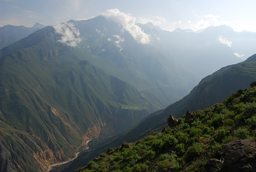
The Colca Valley is located in the province of Caylloma. Colca
comes from the words Collaguas and Cabanas, two ethnic groups that
lived along the Colca River. This canyon has a depth of 4,160 m, and
is the fourth deepest canyon on the planet.
The province of
Caylloma, generically designated as "Colca", is part of the
department of Arequipa, in Peru, and is located in the extreme
northeast of this region. The province has the Colca Canyon as its
main stage and it is in its surroundings that the populations that
identify it have settled.
Caylloma, whose name comes from one
of the local towns, has an area of 11,990.24 km² and borders the
department of Cuzco to the north, the provinces of Camaná and
Arequipa to the south, and the department of Puno. to the east, with
the province of Castilla to the west and the province of Condesuyos
to the northwest.
In 2019, UNESCO declared the Colca Canyon
and Andagua Volcanoes a global geopark. It is one of the largest
tourist destinations in Peru.
History
The original "Witiwiti" dance by natives of Tapay.
Throughout thousands of years, man has occupied the Colca, and as a
result of this occupation, samples of a culture that has contributed
important contributions to humanity have remained.
Around 5000 to
6000 BC. C. hunters and gatherers roamed the area behind the herds of
South American camelids and a series of plant species that were the
basis of their diet. Cave paintings and stone tools have remained from
this in different places. The presence of these manifestations
throughout the area where the Kóllawas, Ccawanas and Ccaccatapay nations
would later develop, shows a remote presence of hunter-gatherers in
search of food, who gradually domesticated plants and animals as shown
in the drawings (painting on engraving and reliefs) made in the Cueva de
Mollepunco in Callalli, a rocky shelter that was occupied when the
processes of domestication of camelids and the transformation of groups
of hunters into breeders of South American camelids took place; On its
walls there are paintings that represent the activities of collecting
and hunting animals and also in the low relief engravings corals with
camelids and men pulling them with ropes are represented.
After
thousands of years, only through community work was it possible to carry
out the task of overcoming the adversities of the environment and
beginning to dominate nature. The Andean social organization made it
possible for man to overcome the difficulties of this adverse geographic
space and between 200 AD and 600 AD, after this long process of
domestication of plants and animals, it passed to an agrarian economy in
which the man of the Colca, begins to build platforms, developing a
rainfed agriculture and in this way the Andean landscape was modified
giving it a physiognomy peculiar.
As early as 600 AD to 900 AD
the Wari Empire, coming from Ayacucho, made its appearance in all this
part of the Andes, incorporating these towns into its administration.
During this period, administrative centers were established that
controlled the different valleys, rainfed agriculture gave way to the
irrigation of terraces through canals, for which a whole constructive
and hydraulic technology had to be used. Ccachulli (Tuti) and Achachiwa
(Cabanaconde) stand out from this moment, probable administrative and
ceremonial centers; agriculture was the economic activity of the
inhabitants of the middle-low valley while grazing was the activity of
the populations located in high areas.
The samples found in
Cabanaconde are found in the wall that is known as "La Trinchera", built
in stone, of great magnitude at the base of the wall and of lesser
proportion in the upper part; some stones are worked, while others show
a rough appearance, it runs along the slopes and summits of small mounds
until it reaches the natural walls that form the canyon.
The site
of Ccachulli (Tuti) also seems to correspond to this period, which shows
structures with a circular plan and in the form of a vault in elevation.
Said walls are made with double-row crushed stone, joined by clay;
although it is necessary to clarify that the site has been used since
remote times (late Pleistocene or hunter-gatherers).
The
decomposition of Wari corresponds to the emergence of local societies
that are separating from the imperial administration. It is then that
the Collagua societies arise in the north and Cabana more to the south
and the following manifestations have been found in this period:
Approximately in 1450, the Collaguas and Cabanas are incorporated into
the Inca Empire by Túpac Inca Yupanqui. During that time Coporaque would
have been the center of the Inca administration.
About the Inca
presence in the area, a whole series of stories and traditions have been
elaborated, such as the "Myth of the Incarri" that in the town of Chivay
shows a variant that indicates that during the visit of the Inca Mayta
Cápac, he was granting various benefits to the towns, such as barley and
quinoa to Chivay; water to Maca; winds to Pinchollo; corn to
Cabanaconde; gold and silver mines to Tisco; the cochayuyo to Sibayo;
etc. These manifestations are related to the vertical control of
different ecological floors that the ancient settlers achieved, as the
basis of their economy and organization.
The entry of the
Spaniards into the area occurs in 1535. The Colca inhabited the Colca at
that time, the Collaguas and the Cabanas, for the process of
distributing land to the Spaniards, three "repartimientos" were
distinguished in the area, which were apparently organized according to
the social organization of the existing lordships or curacazgos, that
is, Yanquecollaguas, Laricollaguas and Cabana.