Location: 12 mi (40 km) from Huaraz Map
Info: INRENA, Avenida Centenao 905, Huaraz
Tel. 043 422 086
The Huascarán National Park, declared a protected natural area on
July 1, 1975, as a Biosphere Reserve in 1977 and as a Natural
Heritage Site in 1985, is located in the Peruvian Region of Áncash,
famous for having in its territory 20 snow-capped peaks that exceed
6,000 meters above sea level, and the highest mountain in Peru and
in the entire intertropical zone: the Huascarán snow-capped massif
from which it gets its name.
The Huascarán region was
inhabited by the man from Cueva del Guitarrero from 12,560 BC. C.,
one of the oldest human settlements in Peru; subsequently, sedentary
settlements emerged with a social, political and religious base
associated with nature as an essential part of their cultural and
religious imaginary, among these civilizations the Chavin, Recuay
and Inca cultures stood out. Centuries later, with the arrival of
the Spanish conquistadors and settlers under the command of
Francisco Pizarro between 1532 and 1600, the region and its
inhabitants were divided into various territorial subdivisions,
among which the Huaylas encomiendas to the west and Conchucos to the
east stood out, whose purpose The main objective was to exploit the
mineral veins rich in gold and silver in the mountains and punas,
for which large haciendas and mining mills were formed. This
economic activity boomed for about 400 years until the territory of
the park was declared a protected natural area and only for economic
activities that directly benefit the peasant communities that are
located within its jurisdiction. As of 2013, the park had a
population of 83,047 inhabitants spread over 50 population centers.
The expeditions organized for research and exploration purposes
began in the 1860s, when the researcher Antonio Raymondi decided to
cross and study the Cordillera Blanca and the surrounding territory.
Later, during the first half of the 20th century, several scientific
expeditions were carried out headed by European and North American
scientists, among which Annie Peck, Philipp Borchers, Hans Kinzl and
August Weberbauer stand out, who would be the first to step on the
summits of the Huascarán snow-capped massif and other peaks above
6000 m above sea level In 1964, the The Forest and Hunting Service
of Peru was commissioned to supervise the Cordillera Blanca area,
prohibiting the logging and hunting of native species. In 1977,
UNESCO recognized the Park as a Biosphere Reserve and in 1985
declared it a Natural Heritage of Humanity. In 2004, its
administration was transferred to the National Service of Natural
Protected Areas by the State. Since then, the protection of the park
and its buffer zone includes a large number of habitats, natural
species and around 50 archaeological sites.
The national park
extends over an area of 3,400 km², comprising 434 lagoons, 712
glaciers, deep valleys above the Quechua region and 41 rivers that
feed the Pacific and Atlantic Ocean basins, these characteristics
make it one of the most important in the country in hydrological
potential. Hundreds of species of mammals, birds, fish and reptiles
have been documented, including many that have been put in danger of
extinction and threatened. Forests and grasslands also include
various plant species. The park offers numerous and varied
recreational activities, including mountain climbing, camping,
boating, fishing and sightings. The affirmed and paved roads allow
access to the areas of greatest tourist activity; as well as certain
lagoons and waterfalls. Since 2017 it has hosted the Downhill
Skateboarding World Circuit organized by the International Downhill
Federation, with the Yaku Raymi event held in the months of May and
November.
The park is named after the highest mountain in the Cordillera Blanca, Peru and the entire intertropical zone, the Huascarán snow-capped massif. The word Huascarán comes from the Ancashino Quechua word waska ('rope or rope') and ran ('verbal or adverbial suffix'), so huascarán means arranged like a rope or in a more appropriate interpretation to its context: chain of mountains.
Prehistory
During the division of the supercontinent Pangea, the
eastern territory of the current Cordillera de los Andes — at that
time a plateau with peaks that reached a thousand meters — was an
immense and dense savannah that formed the shore of a sea that
entered from the current Colombia to northern Bolivia. This
temperate ecosystem on the shores of the sea with tributary rivers
of great flow that descended from the original Andes Mountain Range
led to the proliferation of various species of dinosaurs, which
bequeathed an extensive deposit of footprints and fossils in the
current south-eastern territory of the park. national, in lands that
were formed during the Albian stage during the Lower Cretaceous and
are now over 4000 m a.s.l. n. m..
Precolumbian era
The
human presence in the region dates from approximately 13,000 BC, in
and around the park there are several archaeological sites that show
that occupations at altitudes above 3700 m a.s.l. n. m.. were quite
common in their time, the best known remains are Guitarrero, La
Galgada, Tumshucaico (Caraz), Huaricoto (Marcará), Honko Pampa,
Ichic Tiog (Chacas) and Chavín de Huántar. For thousands of years,
the inhabitants of both slopes crossed the Cordillera Blanca through
the Santa Cruz-Huaripampa, Llanganuco-Morococha, Honda-Juitush,
Uquian-Ututo-Shongo, and Olleros-Chavín ravines. On the flanks of
the mountain range and in several of its ravines there are vestiges
of large extensions of agricultural terraces and ancient corrals.
Crop and pasture areas were supplied with water provided by
ingenious systems of dams and canals.
33 archaeological sites
belonging to different cultures have been identified, mainly
influenced by the Chavín culture and well-maintained remains of Inca
influence on the coast and eastern highlands, scattered throughout
the different ecological levels of the park, terraced systems,
roads, chullpas, tombs and fortifications.
viceroyalty and
republic
During the viceroyalty, the territory of the park was
acquired by wealthy Portuguese, Spanish and Creole families,
generally military men who had stood out in Europe or America. These
families founded large estates in order to exploit the adjoining
territory rich in minerals. Mining continued without interruption
for four hundred years and would be consolidated with the arrival of
the Republic. The lands that initially belonged to the peasant
communities were completely taken away from them, which is why
numerous complaints were registered by indigenous people against the
landowners, who placed gates and mayordomos at the entrances to the
various streams, claiming access to the forests for firewood,
pastures and other natural resources of the high zone.
Eventually, the haciendas developed their own methods of using the
resources. This process of privatization of the highlands of what is
now the Huascarán National Park was accompanied in the second half
of the 19th century by indigenous protests known as the Atusparia
Rebellion, which were associated with the continuation of the
collection of indigenous tribute. , despite the loss of communal
lands, and the abuse of the authorities in charge. Subsequently,
starting in 1969, the agrarian reform process handed over the lands
in the lower areas of the valleys to the local populations, and
reserved the higher areas as a government-protected area, which were
in the colony “tierras del comuno”. », where the pastures, forests,
lagoons and glaciers were found.
scans
In the 1860s,
Italian scientist Antonio Raimondi conducted the first detailed
study of the geology of this region and published the book, "The
Department of Ancash and its Mineral Riches" (1873). In addition, he
included observations on the biological and archaeological richness
of the Callejón de Huaylas and the Conchucos area.
The view
of the Yungay mountain range made such a pleasant impression on me
that I decided to examine it more closely by touching, as it were,
the snow with my hand, that is, going up the ravine to its origin,
crossing the snow-capped mountain range and passing through there to
the Pomabamba Province.
Between 1880 and 1900, German
scientists Gustav Steinmann (geologist), August Weberbauer
(botanist) and Wilhelm Sievers (geographer) carried out more
detailed studies within the Cordillera Blanca. On the other hand,
the Frenchman A. C. de Carmand extended Raimondi's observations on
mineral deposits.
In May 1904, Reginald Enock, an English engineer, attempted to climb
Huascarán, reaching only 5,100 meters. On September 2, 1908, the
American Annie Peck, accompanied by two Swiss guides, Gabriel
Zumtaugwald and Rudolf Taugwalder, led the first expedition that
culminated in the summit of the north peak of Huascarán, after three
frustrated attempts in 1904 and 1906.
In 1932, several
members of the Austro-German Alpine Club began scientific
expeditions to the Cordillera Blanca, including the first ascent of
Huascarán Sur. The group was made up of scientists Philipp Borchers,
Hans Kinzl and Erwin Schneider, who, based on their explorations in
the mountain range, published the book "Die Weisse Kordillere" in
1935, considered the first systematic study of the Cordillera
Blanca. New maps were produced highlighting the northern and
southern sections of the range. The club's expeditions conquered,
between 1932 and 1938, the peaks of the snowy mountains Huascarán,
Artensoraju, Huandoy, Chopicalqui, Copa, Quitaraju, Pucahirca,
Contrahierbas and other peaks of the Cordillera Blanca. All the
ascents were carried out with the assistance of Yungaino porters,
among which the following stood out: Faustino Rojo, Miguel Rojo,
Néstor Montes, Lizardo Montes, Augusto Gómez, Pablo Castillo, Luis
Vega, Eusebio Carrasco, Donato León, Luis Laurenti, Luis Paredes,
Severino Chavarría, Alberto Bautista, Humberto and Santiago
Bautista.
In 1950, the cartographer Fritz Ebster was able to
represent the entire mountain range on a single map for the first
time. Kinzl led other expeditions in 1936, 1939 and 1954, which
continued the plan of climbing and studying the snow-capped
mountains, glaciers and lagoons. In collaboration with Erwin
Schneider, he published an illustrated book, "Cordillera Blanca"
(1950), with a trilingual text.
In 1984, the American
botanist David Smith carried out a census of the Andean flora,
registering 799 species within the Huascarán National Park.
creation of the park
The creation of the park dates back to the
1960s, when the senator for Áncash, Augusto Guzmán Robles, presented
a bill to Congress for the creation of the protected natural area.
Following these bases in 1963, the Forestry and Hunting Service
proceeded to the first delimitation of the park, initially named
Cordillera Blanca National Park, and in 1966 it was changed by the
Huascarán National Park Board to the current name. The initial area
covered an area of 321,000 hectares, Ministerial Resolution No.
101 was also issued, which prohibited the felling and hunting of
native species. On July 1, 1975, the Peruvian government created the
Huascarán National Park through Supreme Decree No. 0622-75-AG on the
final extension of 340,000 hectares.
On March 1, 1977, UNESCO
recognized it as a Biosphere Reserve that encompasses the core of
the park, the buffer zone, and the transition zone that includes
several towns and rural settlements. The total area of the
Biosphere Reserve is 1,115,800 hectares, which is equivalent to 30%
of the departmental territory. Finally, on December 14, 1985, it was
also declared a Natural Heritage of Humanity.
The ecological
institutions Birdlife International and Conservation International
recognized the nucleus of the park as an Important Bird Conservation
Area (IBAs, for its acronym in English 'Important Bird Areas'), due
to its high endemism and threats to its populations. While in the
area of the Biosphere Reserve, three more IBAs were recognized:
PE069 Champará, PE072 Cerro Huanzala-Huallanca, PE079 Cordillera
Huayhuash.
In 2004, the administration of the park was
transferred to the National Service of Natural Protected Areas by
the State (Sernanp), which was created the same year. Since then,
the protection of the park and its buffer zone includes a large
number of habitats, natural species and around 50 archaeological
sites.
Location and general characteristics
The Huascarán National Park
is located in the central highlands of Peru, located entirely in the
department of Áncash, parallel to the Cordillera Negra.
Ecologically, it encompasses the Suni and Janca biogeographic
regions and includes the entire Cordillera Blanca. Politically, it
occupies part of the territory of the provinces of Bolognesi,
Asunción, Carhuaz, Huaraz, Huari, Huaylas, Mariscal Luzuriaga,
Pomabamba, Recuay, and Yungay. It extends over 3,400 km² (340,000
hectares) with an extension of 158 km in length. north - south, and
34 km from east - west, it is delimited by 110 milestones in UTM
coordinates.
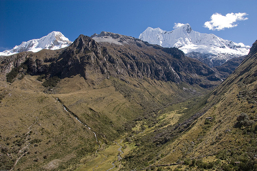
Relief
The territory of the national park is
very rugged; It includes the entire Cordillera Blanca with its
eastern flanks in the area of Los Conchucos and the western in the
area of the Callejón de Huaylas. It has snowy peaks with altitudes
ranging from 5,300 to 6,757 m above sea level. n. m. (Huascarán Sur,
the highest in Peru and in the entire intertropical zone); the
deeply encased ravines that are located transversely to the
Cordillera Blanca, have very steep slopes with a gradient between
85% and 90% that decreases in the part south of the national park
with slopes that fluctuate between 30% to 60%. The width of these
depressions varies between 200 to 400 meters, and in some places
they present extensive lagoons such as those of Llanganuco, Parón
and Rajucolta, product of deglaciation.
The landscape below
5000 m a.s.l. It is typified by a mixture of small and large pampas
surrounded by terrain with semi-steep slopes. These pampas, of
fluvial-alluvial origin, have sand-clay as their predominant
material. While the territories above 5000 meters have lateral
moraines caused by deglaciation and debris cones flanked by very
steep terrain, in some places totally vertical.
Cordillera
Blanca
The Cordillera Blanca extends almost 180 kilometers from
north to south, it is located entirely within the Huascarán National
Park. It has a total of 663 glaciers, 16 snow-capped peaks above
6,000 meters above sea level. n. m. and another 17 above 5000 m
a.s.l. n. m.. It also has more than 269 lagoons and 41 rivers that
drain into the Santa and Marañón rivers.
The geological formations identified in the park area range from the
upper Jurassic to the recent Quaternary, and are made up of
sedimentary, volcanic, intrusive rocks and Quaternary deposits,
which cover the Chicama, Chimú, Santa, Carhuaz, Calipuy formations.
It also has structural features, folds and faults, such as the
Cordillera Blanca fault that forms the batholith of the same name.
The geological structures in the area are very complex, the
Jurassic and Cretaceous formations are strongly folded and faulted.
These deformations are due to the Andean orogenesis at the end of
the Cretaceous and the subsequent phenomena of the emplacement of
the Cordillera Blanca batholith and the spirogenic movement that
affected the Andes in general. The sedimentary rocks that outcrop in
the study area are affected by several folds, with a predominant
northwest-southeast orientation, coinciding with the direction of
the Andes mountain range. These folds are cut by faults of various
magnitudes.
Fifteen geological formations have been studied
in the core of the park, of which the Granodiorite Tonalite
formations stand out with 24.6% of the total territory, the Chicama
formation with 22.8% and the glacial, moraine and fluvioglacial
deposits with 19.8%. , 10.2% and 7.8% respectively.
Active
fault Cordillera Blanca
This fault, which reaches
approximately 200 kilometers, limits to the west with the Batholith
of the Cordillera Blanca, extending from Conococha to the south, to
Corongo in the north. It originated in the Neogene-Quaternary
boundary, when the Andes began their uplift 5.3 million years ago.
Later, in the Quaternary period (2.5 million years), when this
territory was still a plateau with territories that did not exceed
1000 meters in height, the fault began greater activity, greatly
affecting it and causing the sinking of the western block (Callejón
de Huaylas) and the rising of the eastern one (Sierra Oriental de
Áncash) that rose 3000 meters at a rate of 1 mm/year, a constant
that continues today. Seismic geology studies show that the fault is
still active, therefore it is a continental or intraplate
seismogenic source, where violent ruptures with geological
displacements of up to 3 meters can occur, causing earthquakes with
a magnitude of up to 7.4 ML.
Hydrography
glaciers
In
the territory of the park, the glaciers are distributed along the
180 kilometers of length, from the snow-capped Tuco in the south, to
the outskirts of the snow-capped Champará in the north. About 27
glaciers exceed 6000 m a.s.l. and about 200 between 5,000 and 6,000
m. Most of the rivers originating in the valleys of this mountain
range drain into the Santa River basin. The area covered by snow
comprises 504.4 km², which represents 14.84% of the total area of
the park. There are 712 glaciers that represent 486,037 km² and an
estimated volume of 18,458 km³ of hydrological potential in solid
state.
deglaciation
The Santa River basin, in which the
western flank of the national park is located, has been considered
one of the six basins most vulnerable to the effects of climate
change at the national level. According to studies carried out by
the Glaciology and Water Resources Unit of Peru; Within the national
park, in 1997 there was a total area of 693.72 km² compared to the
486,037 inventoried in 2003, which is equivalent to 30% of the
glacial area lost in just six years. While within the Cordillera
Blanca the decrease in the glacial area is 26% in thirty-three
years.
lagoons
Within the limits of the protected area,
434 lagoons have been identified, representing an area of 27.7
km². Most of them are of glacial origin. Bathymetric surveys have
only been carried out in 40 of them, resulting in a volume of
435,086,656 cubic meters.
Rivers
The continental divide of
the Americas, the dividing line between the waters that flow into
the Pacific Ocean and those that flow into the Atlantic, crosses the
park in the middle continuously. So the two parts have an almost
equal surface ratio. There are three main rivers that originate in
the park, the Santa River, the Yanamayo River and the Pativilca, the
first two flow in the same direction from south to north: the Santa
receives the contribution of 23 rivers of the Cordillera Blanca,
which have their origin in 457 glaciers and flows into the Pacific
Ocean, the Yanamayo River receives the contribution of 16 rivers,
which have their origin in 192 glaciers and drain into the Marañón
River, which flows into the Amazon to flow into the Atlantic.
Finally, the Pativilca receives the flow of the Piskaragra River,
which has its origin in 14 glaciers and runs from east to west to
empty into the Pacific.
Climate
The park is located in an eminently tropical area. The
origin of rainfall in this particular area is related to the
transport of fairly humid air masses from the Amazon and to a lesser
extent from the Pacific. The air masses that rise up the flank of
the mountains facing the Pacific Ocean lose moisture during their
ascent. The climate of this area is predominantly dry and cold. This
lack of humidity is influenced by the atmospheric stability of the
desert coast that affects the western flank of the national park. In
contrast, on the eastern flank, the large masses of air caused by
evaporation in the Amazon region have a large amount of humidity,
which, when ascending the mountain range, condenses and solidifies,
forming the snows of the Cordillera Blanca.
Territories
between 3800 - 5000 m a.s.l.
The climate in the territories
above 3,800 to 5,000 m a.s.l. n. m., which encompasses the Suni and
Puna natural regions, is marked by two clearly differentiated stages
during the year. With abundant rains, hailstorms and snowfalls
between the months of November to March; and a marked dry season
between May and October, with sunny days that reach 15 °C and nights
of intense cold in which frosts are frequent and temperatures below
0 °C.
Demography
The population within the buffer zone is
83,047 inhabitants, which is equivalent to 8% of the total Ancashi
population; while in the nucleus of the park there are 50 human
settlements, all of them are indigenous peasant communities. The
entire population is distributed on both sides of the park: 40% in
the Callejón de Huaylas, and the remaining 60% in the Sierra
Oriental de Áncash.
Human development
Educational level
and health
Most of the inhabitants have Quechua as their mother
tongue with moderate use of Spanish. On the other hand, a third of
the inhabitants are illiterate, 20% have secondary education and 7%
have higher education. 66% of the population of the park and the
buffer zone do not have access to health services. This shows that
only 6% are affiliated with the Essalud government program.
Biodiversity
life zones
Holdridge's Life Zones system
establishes a classification of different land areas taking into
account the bioclimatic behavior in the area, which depends on the
latitudinal location, altitude and humidity. Of the total of one
hundred and four life zones described for the world through this
system, Peru has eighty-four, while the national park has eleven,
nine in its nucleus and two in its buffer zone.
Tropical
desert scrub (md-T). It exists only in the buffer zone, from 2100 m
a.s.l. up to 2800, it has 695 hectares which represents 0.28% of its
territory; It is characterized by the abundance of forests and
climates that fluctuate between 20 and 22°C, with great potential
for agricultural activity.
Flora
Seven different areas are
defined that contain a wide variety of microclimates. This
configures a great diversity of vegetation. 779 high Andean species
have been detected, including 340 genera and 104 families.
In
this plant variety, the Bromeliaceae family is represented by the
Puya (Puya raimondii), a species that is characterized by having the
largest inflorescence known on the entire planet. There are also
forests of queñual (Polylepis spp.) and abundant grasses.
You
can see puya Raymondi stands located mainly in the Carpa and
Queshque streams. There are also relict forests of quisuar (Buddleja
coriacea) and queñua (Polylepis sp), which are located mainly to the
north of the Llanganuco sector. There are also high Andean prairies,
puna grass and various oconales (bofedales), located mainly above
4,500 m a.s.l.
Fauna
As for the fauna, due to the good
condition of the plant formations, there are numerous species. Thus,
more than 120 species of birds and 10 of mammals are recorded. Among
the most outstanding birds are the Andean condor, the torrent duck
and the puna partridge, the slang duck, the Andean duck. There is
also the giant coot and the Andean gull.
Among the mammals,
the wild cat, the Andean cat, the spectacled bear, the ruminant
taruca with horns larger than the deer, and the vicuña stand out.
Other species of importance are the gray deer, the puma, the
vizcacha, the weasel or muca, the añaz or skunk, the Andean fox,
among others.