Location: 31 mi (50 km) North of Colón, Entre Ríos Province Map
Area: 85 km²
Info: Ruta Nacional 14, Ubajay
Tel. (03447) 493 053
Open: daily
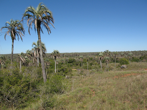
El Palmar National Park (legally El Palmar National Park and
Reserve) is located in the center-east of the province of Entre Ríos
in Argentina, on the right bank of the Uruguay River. It has a total
area of 8,213 hectares and is located in the Colón department,
which is why it is also known as Palmar Grande de Colón or Palmar de
Colón. It is one of the southernmost natural palm groves on the
planet. Within the park are the ruins of Calera de Barquín. Since
June 5, 2011, it has been part of the Palmar Yatay Ramsar site. The
national park has a Management Plan approved in 2015.
General
characteristics
The protected area was created with the aim of
preserving a representative sector of palm groves of the yatay
variety (Butia yatay), a native species that lives between 200 and
400 years. Yatay palm trees were originally distributed not only in
this region, but also in sectors of the provinces of Santa Fe,
Corrientes and Chaco. Its population was significantly reduced due
to the installation of crops and excessive grazing. Due to its
proximity to the main urban centers of the country, this park is one
of the most visited and well-known in the Argentine Republic. The
striking of its landscape populated with palm trees, the gallery
forests that populate the banks of the rivers, the Uruguay River and
the abundance of its wild fauna are the main attractions. It is
crossed by the Ubajay, Los Loros, Palmar and Espino streams.
1,000-year-old settlements were found in the area, which
correspond to the culture that gave rise to the groups of hunters
called Yaros. Later they merged with Charrúa groups. Towards 1750
the Spanish military expeditions dismantled the indigenous groups.
Since 1650, the indigenous people of the missions of the Society
of Jesus in the Yapeyú Reduction exploited deposits of organogenic
limestone (lime) in the place called Vuelta de San José. In 1768 the
Jesuits were expelled and the lime kiln ceased to be exploited. The
property of the lime fields was sold to Manuel Antonio Barquín, who
put it back into operation, becoming known as Calera de Barquín. The
extracted lime was sent by river to Buenos Aires and Montevideo,
establishing in the place employees and slaves who worked in the
lime kiln, building some buildings.
By 1825 the lime kiln was
abandoned due to the wars and in November of that year it was
recovered by Barquín's daughter, Bárbara, and the British company
River Plate Agricultural Association was established there, led by
John Thomas Barber Beaumont, who settled 50 British settlers.
dedicated to the cultivation of wheat, who soon after had to leave
the place. In 1857 the company Sociedad Arcos, Bilbao y Bragge took
over the place to exploit the fruit of the yatay palm tree, but
shortly after the area was acquired by Justo José de Urquiza from
Barquín's successors.
During the Jordanian rebellion on
October 11, 1873, the battle of Calera de Barquín took place, when
the steamship Coronel Espora under the command of Captain Enrique
Guillermo Howard destroyed a coastal battery of two light pieces
that the sailor Juan Cabassa commanded at the head of 200 riflemen.
.
Around 1950, the company Salvia Hnos. began the extraction
of gravel there, leaving some ruins of its activities, among them
the sandy beach that was formed by the washing of the extracted
material. This company occupied part of the ruins and worked until
the expropriation of the land.
In 1827 the French naturalist
Alcide d'Orbigny visited the provinces of Entre Ríos and Corrientes
and expressed concern that the advance of agricultural exploitation
threatened the yatay palm forests. In 1919, the Belgian botanist
Lucien Hauman expressed himself in the same way, who in 1923
proposed the creation of a reserve to protect palm trees. In 1945
and 1948 there were legislative projects to create a national park
for the yatay palm groves. In 1960, the Directorate of Agriculture,
Forestry and Forests, Lands and Colonies of Entre Ríos declared the
Butia yatay palm tree a protected species through resolution No.
166.
Management, tourism and infrastructure
The El Palmar
National Park is located at km 198 of the National Highway 14
General Artigas (with which it borders at about 1800 m). The
distance from the nearest cities is: Ubajay: 7.0 km; San Salvador:
34.5 km; San Jose: 41.5 km; Colon: 49.5 km; Villa Elisa: 50.5 km and
Concordia: 61.5 km. This city has the closest airport (Airport
Comodoro Pierrestegui).
paths and trails
From the national
highway 14, it is accessed by a 350 m path to the entrance and
access collection point called La Portada. Through a fork prior to
that post, you can access a regional tourist information post and
one for the sale of regional and tourist articles.
The Main
Road links La Portada with the Services Area through a gravel route
permanently preserved by road machinery. This road is 11,500 m long
and ends at a parking lot. At 10,100 m from La Portada, the road
forks giving access to the Calera del Palmar Historic Site (at 1,100
m) and the 500-m-long beach and spa on the Uruguay River located
immediately. It is a spa that is not enabled, but its use is allowed
since during the summer season the Safe Beaches Program is carried
out and a lifeguard service is contracted with buoys and flags. The
historic site has buildings in ruins: distillery, stone house,
viewpoint, base, Blanco post, chapel and cemetery.
From the
Main Road there are 4 other vehicular roads: to the Mirador Arroyo
Los Loros (3 km, allowed for use on foot and by bicycle), to the
Mirador La Glorieta (6 km), to the Mirador Arroyo El Palmar (6 km )
and to the detachment of the Argentine Naval Prefecture (3 km, only
for excursions contracted for bicycles). There are 5 pedestrian
paths called: La Glorieta (1000 m circular, starts and ends at La
Glorieta viewpoint), Yatay (500 m circular, starts and ends on the
way to La Glorieta viewpoint), Arroyo El Palmar (400 m , links the
viewpoint of the El Palmar stream with that stream), El Mollar (1400
m circular with informative signage, begins and ends on the main
road and is linked to the Los Loros stream by a small path) and La
Calera del Palmar ( of 1000 m with informative signage, links the
administration with the historical site along the coast of the
Uruguay River). As of September 2008, the park has two bird
observatories that are located in strategic places where birds go to
feed or nest: the Pastizal Observatory (located next to the El
Palmar Arroyo Path) and the Forest Observatory (path of 300 m from
Calera del Palmar). On the coast of the Uruguay River,
catch-and-release fishing is allowed in the designated area.
Service area
The Services Area has:
parking lot;
first aid
post;
Visitor Center (in the old stable shed of the Estela
Sauviet ranch) where information and brochures are provided and it
has a permanent exhibition and an auditorium;
picnic area
equipped with tables and armchairs and Gardens of the Intendancy,
with a viewpoint in a ravine over the Uruguay River.
The
concession services are:
Camping El Palmar, organized and with 7
hectares, is the only site enabled for bonfires and has a descent to
the Uruguay River. It is open all year round and has a capacity of
200 tents, with two restrooms with hot water showers, two equipped
shelters-barbecues, grills, a grocery store and an El Palmar
sandwich shop (in the old laborers' house on the Estancia de Estela
Sauviet), which has public telephones and a patio with tables.
position to hire excursions on horseback or in volanta, offering
guided excursions to the Laguna de las Tortugas Circuit (5 km round
trip) and the El Palmar Circuit (9 km round trip);
position to
hire canoe excursions, which offers the Los Loros Arroyo Circuit
(2,000 m), the Ubajay Arroyo Circuit (4,000 m), the La Calera Naval
Prefecture Detachment Circuit (1,200 m) and the San José Island
Circuit (of 8000 m with the option to spend the night on the island
that is outside the national park). At the same post you can hire
guided excursions on foot along the authorized trails and on
all-terrain bicycles for the circuits Arroyo de Los Loros (3,000 m),
La Calera Naval Prefecture Detachment (1,200 m), Mirador La Glorieta
(1,200 m), 11,500 m) and La Calera de Palmar Historic Site (1,000
m).
position to hire boat excursions, which depart from the
detachment of the Argentine Naval Prefecture and travel along the
coast of the Uruguay River to San José Island, with observation of
the intangible area;
Artisans' Corner with non-permanent stalls
selling handicrafts;
External tourist services
Since 2003,
a 7-km, 90-minute tourist rail service on Saturdays and Sundays in
two zones with two wagons was carried out as a local undertaking
between the Ubajay station (converted into a museum) and the bridge
over the Palmar stream in the vicinity of the El Palm grove. Since
July 2010, due to works on Highway 14, the service has been
suspended.
The guided tour service is carried out by approved
guides who are hired from private agencies outside the national
park.
Management and zoning plan
El Palmar National Park
has had a Management Plan since 1994. For the execution of this plan
there is a Local Advisory Commission. Through the plan, controlled
burning of grasslands is carried out to reduce the risk of fires,
which have devastated the park on several occasions. The Control of
Exotic Mammals program is also carried out, allowing the controlled
hunting of the European wild boar and the axis deer by local hunters
and using the meat. Projects are also promoted with nearby
communities, such as interactive Parks and Schools with the Berduc
school, with the historical museum La Estación de Ubajay and the
Oral History museum with residents of nearby towns.
The management plan zoned the national park in:
intensive use
area: contains the visitor service infrastructure. It is made up of all
the roads and trails open to the public, the entrance, the campsite, the
services, the quartermaster and naval prefecture;
historical-cultural
zone: educational and investigative purpose. It contains the ruins of
the Barquín lime kiln. It is the smallest area;
extensive use zone:
educational and recreational purpose, with low intensity public access.
Area contiguous to the previous zones, formed by two sectors;
recovery zone: temporarily in restoration of natural environments.
Adjacent to the areas with the greatest public presence;
intangible
area: closed to visitors, it has the highest degree of environmental
preservation. It is made up of two sectors to the northeast of the park
and the area to the south of the El Palmar stream, with two extensions
to the north of it located near the entrance and on the coast of the
Uruguay River.
Ambient
It is characterized by being
representative of the Espinale ecoregion (specifically the Ñandubay
district), which is part of the Chaco phytogeographic domain. This
ecoregion is characterized by the presence of low forests of xerophytic
species and savannahs. In this national park, some typical species of
the Pampas grassland and the Paraná jungle are added.
The
landscape is a flat, gently rolling plain with highly variable soils.
According to the soil conditions, the savanna environments of the
national park are distributed: palm-grasslands, xerophilous or
semi-xerophilous forests, grasslands, floodplain lowlands and ex-quarry
wastelands (anthropic environment). The savannah is interrupted by
jungle and riparian gallery forest, or marginal jungle on the banks of
streams. In all environments there are small rocky outcrops of
sandstone.
The grassland is intimately linked with the palm
groves, forming a unique ecosystem (palm-grassland), which provides food
and shelter to innumerable species of animals: a large number of
insects, reptiles -such as the jararará-, several species of snakes,
small rodents , the wild cat and typical birds of these environments,
such as the white and royal woodpecker.
Following the undulations
of the terrain, the yatay forests thin out towards the lower areas,
giving way to extensive savannahs, dotted with espinillos, talas and
ñandubayes through which rheas, ferrets and skunks pass.
The
grasslands that occupy the gentle slopes are confused with the
grasslands of the lower and floodable lands, forming aquatic
environments rich in fauna, which are home to batrachians and birds such
as the chiflón, the yellow chest and the ipacaá among others. There are
also painted turtles.
In the vicinity of the campsite there is a
dense and low formation, the xerophile mountain, in which the molles,
espinillos and ñandubayes grow, along with numerous bushes, adorned by
vines such as the passionflower or mburucuyá. Here it is common to
observe the mountain foxes. Inside the campsite, the numerous
vizcacheras are signposted, in which a large population of this
nocturnal rodent lives.
The lower shores of the Uruguay River are
covered by profuse vegetation, although in some sectors there are
pronounced ravines up to 15 meters high. This humid formation, which is
an impoverished extension of the missionary forest, is called gallery
forest and contains a great diversity of plant species. Vines, lianas
and epiphytes abound (such as the carnation of the air and old man's
beard, among others), which are associated with different tree species
such as the northern arrayán and the laurel. The black-faced spider mite
and the pitiayumí are the most characteristic birds that find refuge in
this forest formation. A similar environment borders the different
streams that flow through the park, the most important being Palmar and
Los Loros. These water courses are the favorite habitats of the largest
rodent in the world: the capybara and other mammals such as the river
wolf, the coypu or badly called otter, along with waterfowl such as the
biguá and kingfishers.
The paradise tree is a species native to
Asia, which invaded the park threatening to modify its landscape. For
this reason, it is sought to eradicate it from the national park.
The climate is humid temperate with no dry season and abundant
rainfall (mainly in spring and summer) with no dry season (average 1,298
mm) and frost from May to October. The average annual temperature is
18.9 °C, presenting summers without excessive heat and winters that are
not harsh. The average wind is 8 km/h, predominantly from the northeast,
southeast and east. The average relative humidity is 75%.
Fauna
By resolution n.o 122/98 of August 20, 1998 the
Administration of National Parks approved a List of Vertebrates of
Special Value of the national park El Palmar, consisting of: an
amphibian, 2 reptiles, 11 birds and 13 mammals.
Amphibians:
cururú toad (Bufo paracnemis).
Reptiles: overo lizard (Tupinambis
teguixin), white-fronted blind snake (Leptotyphlops albifrons).
Birds: woodpecker (Rhea americana), creole duck (Cairina moschata),
common mountain peacock (Penelope obscura), Pampean sparrow (Asthenes
hudsoni), collared yetapá (Alectrurus risorius), yellow cardinal
(Gubernatrix cristata), collared capuchin ( Sporophila zelichi),
gray-crowned cappuccino (Sporophila cinnamomea), black-throated
cappuccino (Sporophila ruficollis), cinnamon cachilo (Donacospiza
albifrons), federal (Amblyramphus holosericeus).
Mammals: earthworm
(Dasypus hybridus), gualacate (Euphractus sexcinctus), common mule
(Tadarida brasiliensis), mountain fox (Cerdocyon thous), straw cat
(Oncifelis colocolo), mountain cat (Oncifelis geoffroyi), lesser ferret
(Galictis cuja). ), common fox (Conepatus chinga), river wolf (Lontra
longicaudis), scorpion (Lagostomus maximus), carp (Hydrochaeris
hydrochaeris), rat rabbit (Reithrodon auritus), coipo (Myocastor
coypus).
Administration
By resolution n.o 126/2011 of the
Administration of National Parks of 19 May 2011 it was provided that El
Palmar should be classified for administrative purposes in the category
protected areas of complexity II, for which the national park has in
front of it a designated mayor, from which depend 4 departments
(Administration; Works and Maintenance; National Park Ranger;
Conservation and Public Use) and 2 divisions (Dispatch and Desk of
Entries, Exits, and Notifications; Human Resources and Training). 100
meters from the visitor centre, in the old main house of the helmet of
the estate built in 1902 and which belonged to Estela Sauviet, heiress
of Justo José de Urquiza. Within the part are also the sectionals La
Glorieta, La Portada and Chapel. Next to the former is the Fire,
Communications and Emergency post, which has sanitation and first aid.