Location: 75 mi (120 km) Northwest of Mercedes, Corrientes Province Map
Area: 20,000 km²
Open: 7:30am- 6pm daily
Official site
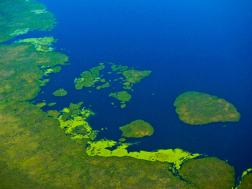
Iberá Wetlands is located 75 mi (120 km) Northwest of Mercedes, Corrientes Province in Argentina. Iberá Wetlands covers an area of 20,000 km² making it one of the largest wetland biosphere in the World. Iberá Wetlands is an extensive area of wetlans, swamps, bogs, lakes and various bodies of water between rivers of Rio Paranand Rio Uruguay. Parts of Iberá Wetlands are protected by Iberá Provincial Reserve that covers an area of 13000 square kilometers (5000 sq mi), although there are ongoing discussion of turning the site into a national park. After with a total area of 15,000- 20,000 sq km (5800- 7700 sq mi) it is the second largest wetland (first being Pantanal in Brazil) in the World.
Ibera Wetlands are full of diversity in both flora and fauna. Many of the animals are endemic and endangered.. This includes march deer (Blastoceros dichotomous), Pampas deer (Ozotocerus bezoarticus), capybara (Hydrochoerus hydrochaeris) and many others. Some of the most dangerous animals that can be found here are several species of caiman crocodiles and constricting large snakes.
The approximate center of this system is located at coordinates
28°36'00″S 57°49'0″W.
In Argentina it occupies about 12,000 km²,
which are part of a much larger system whose surface is estimated at
around 45,000 km².
Due to its peculiar geography and difficult
access, the area has a rich and varied animal population. The native
fauna includes numerous threatened species for which this is one of the
last remaining habitats; among them, the marsh deer (Blastoceros
dichotomous), the pampas deer (Ozotocerus bezoarticus), the capybara
(Hydrochoerus hydrochaeris), the maned wolf or maned wolf (Chrysocyon
brachiurus), the alligator (Caiman latirostris) and black (Caiman
yacare), the curiyú boa (Eunectes notaeus) and the river wolf (Lontra
longicaudis), the howler monkeys (or carayás), as well as an enormous
variety of birds such as the pirincho among many others. The
ichthyofauna is also very varied and abundant, standing out the dorados,
armadillos, surubíes, pacúes, mojarras, tarariras and palometas. The
jaguars seem to have been extinct in this area during the first half of
the 20th century, as well as the tapir, the gargantilla wolf, the
collared peccary and the anteater; the latter recently reintroduced. The
exuberant local flora includes numerous aquatic species such as the
camalote, and water poppies —which give rise to the phenomenon of the
reservoirs, authentic floating islands that complicate the geography of
the lagoons— as well as extensive pyrizal forests.
On April 15,
1983, by law 3771, an area of about 12,000 km² —divided between the
departments of San Miguel, Concepción, Santo Tomé, San Martín and
Mercedes— was established as a Provincial Nature Reserve by the
Government of the Province of Corrientes. , on which it currently
depends, such a reserve is the largest protected area currently
(September 2007) in the Argentine Republic. It is considered a wetland
of international importance under the terms of the Ramsar Convention.
The Iberá region is located in the central depression of La Crespa,
flanked by higher terrain of a geologically diverse nature on the banks
of the Paraná and Uruguay rivers, which constitutes the center of the
province of Corrientes. It takes the form of a wide plain, with a slope
of just over 1‰ that allows slow drainage in a northeast-southwest
direction.
The formation of the Iberá estuary system is not
exactly known. The bed of the Paraná is excavated on a porous basalt
substrate that presents important fractures in several points; The
largest of these faults crosses the entire province of Corrientes
diagonally, and intersects with the bed of the Paraná about 90
kilometers downriver from the city of Posadas with a basaltic wall of
considerable thickness. It is speculated that the presence of this wall
formerly diverted the course of the river, taking it southeast through
the shallows that today make up the Iberá system and giving rise to the
current morphology of the area. The river channel would have taken its
present form once erosion made it possible to flow through the rocky
bank of the Yacyretá-Apipé falls. Wind erosion would also have helped to
depress the hills and blades that cross the estuaries.
This
theory is supported by the alluvial origin of the soil, composed of
layers of sand and silt on an impermeable clay bottom that prevents
direct water drainage. The current surface layer is made up of sands of
fluvial origin, accumulated between the Upper Pliocene and the Lower
Pleistocene.
The low slope and the botanical density in the water
bodies make the drainage of the system markedly slow; the water flows
little by little towards the southwest, until draining through the
Corrientes and Miriñay rivers, towards the Paraná and Uruguay basins
respectively. Frequent rains, especially during spring and autumn,
replenish the level of the estuaries, which have not shown any tendency
to change in recent years; Thus, the water level remains stable,
although with seasonal variations. Annual rainfall is in the order of
1,200 to 1,500 mm, while evaporation rises to 1,000 mm in an equivalent
period.
The exact area occupied by the marshes varies with the
height of the rivers in the region, with which they are connected
underground; Although the southern margin of the area is clearly defined
by the natural limit of Entre Ríos geology —an area of low hills that
occupies the southern half of the province—, its northeast and northwest
borders have no solution of continuity with the rest of the landscape. .
The average depth of the lagoons does not exceed 3 m, varying around 1 m
between the highest and lowest levels of the annual cycle.
The
bottom relief is generally flattened, at an average height of 65 meters
above sea level. The most outstanding geomorphological features are the
lagoons of diverse conformation that make up the main axis of the basin,
connected to each other by streams and surrounded by permanent marshes.
The environments are mainly permanent lentic, represented by lagoons and
estuaries, with some peripheral temporary zones and extensive transition
areas that are semi-permanently flooded, and lotic sections represented
by the drainage channels that connect them.
To the southwest, and
before returning to the current course of the Paraná, the waters of what
is now the Iberá wetland are encircled or dammed by madrejones (on the
Paraná River side) and by the slight plateau of Payubré (or Pay Ubré and
Mercedes) area that was naturally jungled and that naturally extends
into the province of Entre Ríos in what used to be an extensive Montiel
Forest.
hydrographic structure
Along the arc of the area
several permanent lagoons or estuaries of various lengths can be
distinguished, of which the largest are the eponymous Iberá, and the
Luna lagoon, on whose shores the town of Colonia Carlos Pellegrini is
located, the largest base recommended to visit the region. The
Fernández, Galarza, Medina, Paraná and Trin lagoons also exceed 15 km²;
The system of lagoons is generally very shallow, although in times of
flooding they can reach three meters. With them, scarce areas of dry
land alternate, mostly low and sandy hills, and a large extension of
wetlands, that is, floodable or flooded land.
The exact profile
of the firm surface is constantly changing; added to the visual
continuity between the mainland and the ravines —given both by the large
amount of semi-submerged vegetation and by the formation of reservoirs,
tangled formations of floating vegetation to which the accumulation of
wind-generated earth and the intertwining of roots it provides enough
solidity to walk on them; orientation becomes extremely difficult, both
on land and in lagoons.
Despite being located in subtropical zones, Iberá's climate is clearly tropical due to the high atmospheric humidity that retains solar heat in this environment. Winter is relatively dry (relatively, since humidity is perennial), with minimum temperatures reaching 5 °C, and heavy rainfall during autumn and spring. Summer is also humid and very hot, with highs that can exceed 50 °C. Annual rainfall is around 1700 mm.
Upon the arrival of the Spaniards in the 16th century, the area was
diffusely populated by the ethnic groups of those called in Guaraní:
Guaraníes, although many of them were Anteguraní peoples who had been
forcibly guarantied (around the 15th century, the Avá or Guaraníes
invaded the territories of indigenous peoples). like those that such
Indo-American invaders called "mocoretás", the Guarani practiced
cannibalism with the males of the ethnic groups that were an obstacle to
their expansionism). Even until the beginning of the 20th century, due
to the fact that "screams" were heard coming from the innermost areas
and then unexplored by the "whites", it was assumed that such natives
still inhabited the estuaries.
Avifauna in the Esteros del
Iberá.
Due to the difficulty in accessing the Iberá marshlands,
settlements in the area have been very scarce, although some populations
on its northeast margin —especially Concepción Yaguareté-Corá— date back
to colonial times. The Jesuit reductions occupied territories adjoining
the estuaries, but the area of marshes and lagoons was considered
uninhabitable. Throughout the 18th and 19th centuries it remained
generally free of stable settlements, although it provided a haven for
outlaws and a source of livelihood for hunters ("mariscadores") and
fishermen.
The first scientific investigation of the area's
natural riches was due to Alcide d'Orbigny, a French naturalist who
visited the area in the late 1820s as part of an expedition to South
America commissioned by the Musée d'Histoire Naturelle in Paris. Among
the seven volumes of his Voyage dans l'Amérique Méridionale are the
first systematic observations of the Iberá ecosystem. The turbulent
regional political situation and the scarcity of means would delay local
interest in it until the 1930s, when the recently created National Parks
Administration presented to Congress the first project to create the
Iberá National Park, the result of negotiations with the provincial
government.
Both this and two other projects presented in later
decades failed; the reluctance of the province to commit an important
part of its territory in exchange for dubious institutional support
played an important role in these failures. The industrial interest in
the area — expressed in a development plan from the 1970s that promoted
the construction of a canal in the San Miguel area to flood the
estuaries with the waters of the Paraná and form an interior lake, whose
waters would be derived towards the Salto Grande Dam, through the
Miriñay River, to increase the performance of the generating plant—whose
performance for the ailing economy of Corrientes took precedence over
ecological interests, was also a factor of weight. The delay in
intervening had serious consequences on the fauna of the area, seriously
decimated by poaching and the defensive incursions of the region's
ranchers against the predatory felines. At the beginning of the 1980s,
species with commercial value -especially the black alligator, whose
leather was used in leather goods, but also the yaguareté, hunted for
its skin and to protect herds, the different species of deer and deer
and several birds—were at high risk or had disappeared from the area,
and ecosystem disturbances threatened many others.
The
combination of insistent claims from the National Parks Administration
and the impossibility of agreeing with the federal government the
administration of the ecological heritage of the area moved the
government of Corrientes to declare the creation of the Iberá Nature
Reserve on April 15, 1983 by provincial law 3771. The intention of the
project was to combine the conservation and recovery of native species
and the elimination of exotic species with the development of tourism in
the region. Conservation tasks were defined and financial support and
staffing for these tasks were regulated. However, the great effort made,
especially to combat poaching and gradually restore the balanced state
of the ecosystem, was seriously affected by the economic situation in
Argentina in the two decades that have elapsed. However, the recovery
has been remarkable and the conservation of numerous species is
guaranteed.
The neighboring work of the Yacyretá dam influenced
the region from its completion in 1994, due to the rise in water level,
and the total flooding of part of the ecosystem. Decree 1577/94 of the
province of Corrientes regulated the conservation units within the dam's
area of influence, as well as financial support from the Binational
Entity in charge of the works.
On December 23, 2015, after the
donation of 150,000 hectares of land (largely flooded) that the American
environmentalist Douglas Tompkins had bought at a very low price,
through the express delegation of his widow Kristine McDivitt, in
December 2018 the creation of the Iberá National Park was announced.
The aquatic vegetation is lush and covers extensive areas.
The camalote (Eichhornia spp) is the most widespread genus and generally
forms the basis of the reservoirs, together with the water poppy
(Hydrocleys nymphoides). The aquatic nettle (Cabomba caroliniana), the
reed (Scirpus californicus) and the achiras or pehuajos (Thalia spp).
Also, you can see on the surface of the irupés waters or water lilies,
lentils, cabbages, lilies and water hyacinths and small ferns.
Earth and seeds carried by the wind are deposited on the reservoirs; the
density of its base is enough for terra firma species to grow on them,
both shrubs and trees (ceibo, curupí, river laurel and dragon blood,
among others).
The ñangapiri or pitanga, the lapacho, the laurel,
the ombú, the willow, the timbó, the urunday, the catiguá, and the
alecrín are the most representative species of the mountains or
hygrophilous forests, together with the caranday and pindó palms (the
pindó palm trees produce fruits that are the main food for carayá
monkeys).
Towards the south, the vegetation transforms into
grasslands and savannahs, appearing in dense groves of carob trees
(Prosopis nigra), ñandubay (Prosopis affinis) and espinillo (Acacia
caven).
The largest species are the marsh deer
(Blastoceros dichotomous, in Guarani guazú puku) and the pampas deer
(Ozotocerus bezoarticus, in Guarani guazú ti'í). The first, an excellent
swimmer, extends throughout the region, living on the reservoirs for
long periods of time, which is why it is difficult to spot except from
boats. The second, smaller, is restricted to the mainland area. Both
species are considered endangered and are listed in Appendix I of the
Convention on International Trade in Endangered Species of Wild Fauna
and Flora (CITES), which absolutely prohibits their hunting and trade.
Difficult to observe due to their shy habits —and also strictly
protected by CITES— are the maned wolf (Chrysocyon brachiurus), a large
native canid, the river wolf (Lontra longicaudis, a relative of the
otter) , and the wild cat (Oncifelis geoffroyi). On the contrary, the
capybara (Hydrochoerus hydrochaeris) is easily found today. It is an
amphibious herbivorous rodent. Its weight in an adult state exceeds 70
kg and it measures approximately 1 meter in length and 60 cm in height.
Its appearance is similar to that of a giant guinea pig, robust and
without a tail. Solid trunk, thick head, wide and divided snout, small
eyes, poorly developed ears and very cleft upper lip. The legs are short
with four toes on the forelegs and 3 toes on the hind legs, joined by a
small swimming membrane. The coat is dense, short and rough. The general
coloration is light gray.
Reptile species include the ubiquitous
black alligator (Caiman yacare) and overo alligator (Caiman
latirostris). Both exceed two meters in length on occasions, although
large specimens are rare due to intense poaching before the park was
established. The two species have easily repopulated and are now easy to
spot. Several species of snakes—including the highly poisonous pit viper
or cross viper (Bothrops alternatus), rattlesnake (Crotalus durissus
terrificus) and coral snake (Micrurus pyrrhocryptus), as well as the
harmless water cobra (Hydrodynastes gigas, in guaraní ñacaniná), false
jarará (Pseudotomodon trigonattus) and the curiyú constrictor (Eunectes
notaeus)—, of turtles, of lizards —among which the overo lizard
(Tupinambis teguixin) stands out— complete the panorama, to which are
added numerous species of amphibians of all sizes.
The giant
anteater or yurumí (Myrmecophaga tridactyla) existed naturally in the
area until 1965 but was exterminated by humans, it has recently been
reintroduced.
The tapir or mboreví (Tapirus terrestris), the
collared peccary (Pecari tajacu) and the giant otter or ariray
(Pteronura brasiliensis) have also been reintroduced.
In 2016,
the reappearance of the medium-sized felid called the ocelot (Leopardus
pardalis) has been observed.
As for the jaguar or "tiger"
(Panthera onca), this maximum American feline was exterminated in the
1960s in the province of Corrientes (where, however, it is emblematic)
when it was described as a "plague"; However, since 2015, the plan to
reintroduce the "tiger" or "yaguareté" in the Iberá marshes has been
active, based on specimens that are in captivity and whose offspring
would be returned to the wild in the "marshes", "wetlands". "and
wetlands of the Iberá, controlling in this way, since it is a focal
superpredator, ecosystemically, the reproduction of the other fauna. In
May 2015, the first female "tiger" or jaguar, called «Tobuna», was
reintroduced in its natural biome of Iberá.
The area stands out
for its ornithological wealth. The presence of around 300 species of
birds, from more than 50 families, has been recorded.20 Among the rare
species or with some degree of vulnerability are the collared yetapá
(Alectrurus risora), the collared capuchin (Sporophila zelichi) , the
yellow thrush (Xanthopsar flavus), the Pampas espartillero (Asthenes
hudsoni) and the dwarf espartillero (Spartonoica maluroides), the yellow
cardinal (Gubernatrix cristata). The Scarlet Macaw (Ara chloropterus),
the Black-winged Macaw (Crax fasciolata) have been reintroduced.
In total, in the Iberá area it is considered (in 2015) that there are
about 800 species of macroscopic fauna.
Undoubtedly, rural tourism in its ecotourism and active tourism
formats have given the Iberá marshes a physiognomy as a true wildlife
paradise where you can coexist with an ecosystem in full expansion and
development of animal and plant species. It is thanks to tourism and
ecological and conservation awareness that they can fully enjoy
everything that the Iberá marshes are.
There are different
options to access this wonder of nature in Argentina, but the most
recommended and that will never disappoint the visitor is to do it
through Colonia Carlos Pellegrini. There, in a small but prosperous town
with a strong Corrientes identity, tourists will find everything they
need to fully explore this magnificent geography and meet its culture.
It is advisable to choose the lodging or accommodation correctly
because once it is well installed, it is the hotel establishments
themselves that will solve issues such as going on a boat ride through
the Iberá lagoon to meet the plants and animals, and the different
formations that acquires relief: reservoirs, estuaries, etc. An outing
of this nature is essential and it is usually advisable to hire in the
same accommodations that usually have their own dock, boat, canoe or
kayak and guide.
A boat ride is essential to discover the true
essence of Iberá, but there are many other activities to develop. For
example, a good horseback ride provides unique opportunities for
discovery, such as undertaking a guided walk or daring to experience
birdwatching, for which it is recommended to purchase a good bird guide,
a pair of binoculars before the trip. and secure accommodation where you
can get some advice. Being able to distinguish the enormous variety of
birds that exist in the Iberá estuaries is a source of great
satisfaction.
For those looking for a more extreme experience of
access to the estuaries, they should also take a look at rural tourism
in the area because it is in this segment that you will find some
options to stay in estancias, well within this beautiful geography, and
with all the comforts. of the hotel located within Colonia Carlos
Pellegrini.
Iberá Wetlands Interpretation Center - Colonia
Pellegrini
The Iberá Interpretation Center is located on the
shores of the Iberá lagoon, the second largest lagoon in the Iberá
estuaries, in the town of Colonia Carlos Pellegrini, the best base for
exploring the park. Access can be made from the city of Mercedes, from
which it is separated by about 120 km of unpaved road (the pavement of
the first 40 km is currently being built).
The center has an
exhibition room with illustrative material about the history, geography
and biology of the park. From there trails start through the mountain
and bordering the lagoon to observe the flora and fauna. It is advisable
to have a guide, who can be hired in the same place, since the habits
and schedules of the local species make them difficult to spot by the
amateur.
However, the best option to get to know the lagoon is to
hire a water ride in Colonia Pellegrini. Under the guidance of a
connoisseur, the tour allows you to observe the most timid species, as
well as birds and aquatic plants, and walk on the reservoirs. Night
navigation offers the possibility of spotting animals that during the
day hide from the rigors of the sun.
For the visitor, winter
presents the best time to access the park. Although the flora does not
show the splendor of spring, the nuisance caused by insects is much
less. During the summer, moreover, midday hours are impracticable due to
the intensity of the heat.
Since the third
five years of the present 21st century, the development of a scenic
route has been proposed that covers, for 1300km, mainly all the
landscape varieties of this great lake and marsh basin: jungles,
grasslands, low plateaus, swamps or estuaries, etc. with the possibility
of observing various and interesting species of fauna and flora of the
reserve and its surroundings.
This is an ecotourism proposal
promoted by the 10 municipalities of the Iberá basin, to visit one of
the most attractive protected wild areas in Argentina. This circuit,
which can start at any of its ends and will give the visitor a
comprehensive vision of Corrientes, bringing the tourist closer to 8
towns, 16 places and interpretation centers from where to start
excursions by boat, canoe, on horseback or on foot through the area.
largest protected area in the country.