Location: 3 km from Villa la Angostura, Neuquén Province Map
Area: 17.53 km2
Los Arrayanes National Park is situated in Neuquén Province in South Argentina. Los Arrayanes National Park covers an area of 17.53 km2 of Quetrihué Peninsula in the North Nahuel Huapi Lake. Los Arrayanes National Park is named after arrayán trees (Luma apiculata) that are common in the area. The park was established in 1971 to protect these unique and rare specie. Some of the trees reach an age of over 600 years old. There are no direct roads here. You can get here either by boat across the lake, bicycle or by foot. Los Arrayanes National Park is dominated by a relatively cold humid climate. Average temperatures range from 3 C (37.4 F) in the winter months (June- August in the Southern Hemisphere) to 14 C (57 F) in the summer months (December- February). On average Los Arrayanes National Park receives over 2,000 mm of rainfall annually, although most of rain falls in the winter months. Los Arrayanes National Park is part of the Patagonian Andean forest ecoregion, dominated by semideciduous species alternated with peat bogs.
Previous story
The Quetrihué peninsula was part of
the first national park in Latin America, the Parque Nacional del Sur,
created on April 8, 1922 by decree of President Hipólito Yrigoyen.3 On
September 29, 1934 through the sanction of the law No. 1210 -
promulgated on October 9, 1934 - the Nahuel Huapi National Park was
created to replace the South National Park.
Ecology
The park
exhibits a sample of the Andean Patagonian forest ecoregion, in which
semi-deciduous species predominate, alternating with peat bogs whose
extension grows in more southern latitudes.
The climate, only
slightly tempered by the lacustrine influence, is cold and humid, with
intense and constant winds from the west; the valley in which it is
located is of glacial origin, and to the west rises the Andes mountain
range. The wettest season is winter; the precipitations decrease when
moving away from the mountain range, being in the peninsula of about
2000 annual mm.
The relatively small extension of the park
restricts the variety of species present; In the vicinity of the lake is
the forest of southern arrayanes (called quetri or temu in Mapudungun),
and next to it other evergreen species, especially the coihue. The
arboreal vegetation also includes ñires, cypresses of the Guaitecas,
cypresses of the Cordillera, radales, huahuanes, as well as lower
species such as the patagua, the notro or the boldo. The undergrowth is
formed mainly by maqui (Aristotelia chilensis), colihue cane and the
introduced bush rosehip.
The avian fauna is rich, and includes
both species of aquatic habit, such as the imperial cormorant, which
nests on the neighboring islands, and the grey-headed goose, as well as
forest dwellers such as the chucao, several species of woodpeckers, and
the skate.
Next to the water there is also a strongly protected
Patagonian river wolf: the huillín. The forest species are difficult to
spot due to their elusive behavior; They include the monito de monte
—which, despite its name, is not a primate, but a small marsupial—, the
red or culpeo fox, the huiña cat, and one of the smallest artiodactyls,
the pudú.
conservation problems
In addition to the competition
that the introduction of exotics imported from Europe, especially wild
boar and European hare, and cattle, represents for native species,
tourism has caused serious damage to vegetation, especially myrtle
trees. Due to their slow growth, the juvenile specimens were
inadvertently destroyed by visitors, while the removal of the surface
vegetation caused the roots of the older specimens to be exposed,
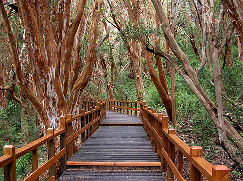
damaging them irreparably in some cases. Today a covered trail delimits
the area of the forest that can be visited, and an area of the park
has been designated a strict nature reserve, and visits to it are
prohibited.
Access
Access to the park can be done both by lake
and by land.
By lacustrine and common way
From Bariloche
It
can be accessed from Puerto Pañuelo, near the city of Bariloche, sailing
through Lake Nahuel Huapi by means of a catamaran service, an excursion
where Victoria Island is also visited.
From Villa La Angostura
It can also be accessed by embarking from the ports of the Quetrihué
isthmus in the La Mansa, La Brava and "Manzano" Bays of Villa La
Angostura.
By landway
By land, from the almost immediate town
of Villa La Angostura begins a pedestrian path of almost 13 km that runs
through the most interesting section of the area open to the public,
connecting that town with the myrtle forest. 1 km from its beginning,
you can also access a panoramic point.
There is no interpretation
center in the park itself, but the myrtle forest area is signposted to
explain the growth stages of this species. Camping is allowed in Villa
La Angostura but not inside this national park.