Location: 1,500 km (932 mi) North of Buenos Aires, Jujuy province
Length: 155 km (96 mi)
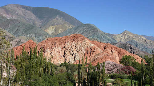
Quebrada de Humahuaca is a picturesque valley situated 1,500 km
(932 mi) North of Buenos Aires, Jujuy province in the North West
Argentina. It is bordered by Valles Templados ("warm valleys" in
Spanish), Sub- Andean hills in the East and Altiplano plateau.
Quebrada de Humahuaca Valley is about 155 km (96 mi) long. Its
unique biosphere is currently listed on an UNESCO World Heritage
Site, recognized on 2 July 2003. The valley of Quebrada de Humahuaca
gets its name from a small settlement Humahuaca and was shaped
largely by erosion by Grande River (Río Grande). Its name Quebrada
can be translated as "broken" indicating the shape of the geologic
formation carved by the Grande River (Rio Grande), while the name
Humahuaca is a name of a local small town.
First evidence of
a human presence in Quebrada de Humahuaca Valley date back 10,000
years ago. Rock art and paintings have been discovered on
surrounding cliffs and small caves. The most popular such location
is that found on the Inca Cueva or Inca Cave. Later evidence show
that the area of Quebrada de Humahuaca Valley was inhabited by
Omaguaca culture. During pre- Hispanic period this area was an
important economic center in the Inca Empire. Several Inca roads as
well as acheological Inca sites are spread through out a region.
The ravine is an arid zone of scenic beauty and rich in cultural
heritage, which is evidenced in the localities that house it from south
to north: Bárcena, Volcán, Purmamarca -where the Cerro de los Siete
Colores stands out, Maimará, Tilcara -where is the Pucará with the
homonymous name. Perchel, Huacalera, Uquía, Humahuaca and Tres Cruces.
The climatic conditions make winter, cool and dry, the ideal season
to visit. The height of the valley varies between 1,600 and 4,500 meters
above sea level. The climate is dry and windy, it rains more in the
summer afternoons and it has a very marked temperature range with night
frosts and days with a scorching sun and temperatures that can exceed
30° C.
To the southwest and to the south, the Quebrada de
Humahuaca descends in altitude and is related through intermediate
valleys such as that of Lerma, with the Quebrada del Toro that descends
from the West (that is, from the Altiplano) and with the famous
Calchaquí Valleys.
The most accepted version for the name Humahuaca refers to the
auto-ethnonym of the Omaguaca ethnic group that inhabited the region.
The self-denomination of such an ethnic group is still difficult to
verify, although it is traditionally related to the Arawak group; It
would be a possible phonemic mutation of Arawak since, in effect, the
Omaguaca ethnic group was the product of a mixogenesis that included the
Chané —the southernmost Arawak bias— with the Lickanantai, Chichas and
Paziocas (or "Calchaquies").
A second version attributes the name
to the Quechua language in the form: uma waka, giving it the meaning of
"head" (uma) and "treasure". However, it is observed that the
denomination huaca (from waka, "sacred place") for treasure is
post-Hispanic in the region.
There is also another meaning of
Humahuaca: "head" (huma) and "cry" (waqay); therefore, the translation
would indicate "weeping head". Some historians maintain that the name
refers to the place of burials of heads or sepulcher of prominent heads.
The towns of Quebrada link history and traditions of ancestral roots.
It is a unique cultural landscape in the world, since the Indian peoples
of the area preserve religious beliefs, rites, festivals, art, music and
agricultural techniques that are a living heritage, an important reason
for it being declared a World Heritage Site. by UNESCO in 2003. Its
current inhabitants are mostly of the Quechua ethnic group. The ravine
was the scene of different ancestral cultures of 10,000 years old, among
them the "Omaguacas", who gave the place its name. "Humahuaca" is
usually translated as "Sacred River", an ancient symbol of what only
changes to remain the same. There are also sites such as the "Inca
Cueva" area (a relatively modern name) where signs (petroglyphs, carved
stones, etc.) whose antiquity is estimated at 10 millennia were found.
In the Quebrada de Humahuaca, there are still Quechua descendants of
the ancient settlers, self-styled native peoples, and they live
coexisting with nature, Pachamama (Mother Earth), the Sun god, the god
of thunder, lightning and all living beings. whom they respect.
Among its attractions is the monolith that indicates the crossing of the
Tropic of Capricorn and the Pucará de Tilcara, a fortification built by
the primitive settlers on top of the mountains.
The Humahuaca
ravine served as a route for the Incas, it was an obligatory passage for
expeditionaries and colonizers and an important commercial route in the
viceroyalty stage. The towns of the colonial era acquired great
importance since they developed together with the ancestral settlements
of the place, in addition to producing a cultural exchange with
neighboring territories in South America, an interaction that began
10,000 years ago and persists today. Its real importance lies in the
fact that the ravine has functioned as a permanent avenue of
interaction, linking distant and different territories and cultures,
from the Atlantic to the Pacific and from the Andes to the southern
plains. It was also the scene of many battles during the War of
Independence and during the war against the invasion of the
Peruvian-Bolivian confederation.
Currently many of these aspects go unnoticed, the aforementioned
native peoples are in a continuous conflict4 with the provincial
government claiming the land that once belonged to their ancestors.
Two towns in the Quebrada de Humahuaca, Purmamarca and San Francisco
de Alfarcito, were integrated into the Authentic Towns Program, carried
out by the National Ministries of Culture and Tourism. with the aim of
valuing the identity of towns with unique characteristics throughout the
country, promoting the appropriation of the local community and the
revaluation of the natural and cultural heritage.
Authentic Towns
are defined as populations that are characterized by preserving their
identity and idiosyncrasy, embodied in different aspects related to
their natural and/or cultural heritage, their architecture, traditions,
gastronomy, landscape, history, religion, crafts, and the origin of its
inhabitants.
San Francisco de Alfarcito, south of Cochinoca, on
Provincial Route 11, very close to the Guayatayoc Lagoon and the Salinas
Grandes.
Its main economic activities are the raising of llamas
and sheep; and agriculture, but it stands out for the great production
of handicrafts with traditional materials from the region.
With
pre-Hispanic roots, its population is small but in constant movement:
nothing like settling down for a few days and living its daily rhythm.
At more than 3,500 meters above sea level, the height dictates the
walking time and the types of crops that can be grown, among which the
Andean papines stand out.
The second destination is one of the
best known. This is Purmamarca, installed in international itineraries
thanks to its Hill of the Seven Colors, undisputed protagonist of the
postcards that depart from Jujuy to the world. This town is an
obligatory stop for those who want to fully experience the northern
carnivals and, from there, enter the Quebrada de Humahuaca and the Puna
in Jujuy.
With colonial architecture and a gastronomy in which
dishes made collectively abound (such as humitas and tamales), this town
has dirt streets and many of its houses still show their adobe walls.
Every day, in the main square, a handicrafts fair is displayed that
tourists visit until minutes before 12 noon, when listening to the bells
of the Santa Rosa de Lima Church, they let themselves be attracted by
its wooden frames and old design.
Hydrography
The Omaguaca
River, which was later renamed the Río Grande, is the most important, it
has several tributaries such as the Chorrillos, Ovaras, Coraya, Churcal,
Pinchayoc, Uquia, Capla and Volcán streams. Its tributary rivers are the
Río Yacoraite, the Río La Cueva, the Río Rodero, the Río Coctaca and the
Río Calete. The Río Grande joins its waters with the Río Perico; then it
joins with the Lavayén River; from there it is called Río San Francisco;
then it empties its waters into the Bermejo River, which empties into
the Paraná River, which flows into the Rio de la Plata and so on, until
it reaches the Atlantic Ocean.
Flora
We will find in the
Quebrada de Humahuaca steppes with bushes, thickets, small grasslands
and few churqui and queñoa forests, swamps and riverside environments,
there is also a great variety of plants, some typical of the region and
others adapted very well to the environment. Among the first is the
cardón (typical cactus whose wood is used for the interiors of homes and
handicrafts, today it is a protected species), trees such as molle,
chañar, carob, among the latter we have the poplar and the weeping
willow. Shrubs such as chilca, muña, añagua, and Cortadera abound.
Fauna
There are numerous wild animals that are generally in the
highlands and less inhabited by man.
The vicuña, the smallest of
the camelids (protected species), the llama (currently domesticated and
provides wool, meat, milk and as a pack animal), the chinchilla, and the
three varieties of flamingos that frequent the Laguna de los Pozuelos
and other lagoons of the Puna, the taruca (deer declared a natural
monument). Among the birds of prey the condor, the owl, the hawk, the
falcon, etc. Also birds such as the blackbird, calandria, the black, the
red chest, the yacto, a variety of hummingbirds, thrushes, quetupies,
sparrows, pigeons, parrots and waterfowl such as ducks, lapwings,
seagulls, herons, parinas, guallatas, gordillos, and tiutilas. It should
be noted that the hunting of vicuñas is prohibited by Law No. 3014/78,
and its regulatory decree 5096.
Agriculture
In the Quebrada de Humahuaca during the summer the
production of fruits and vegetables that supply the market is obtained,
such as peas, chard, onions, corn, broad beans, potatoes, lettuce,
pumpkin, string beans. Fruits; apples, peaches, pear, strawberry,
apricot, grape, quince, etc. The smooth potato or "ulluco" is also
obtained, it is a green, red or yellow tuber, also called "Andean
potato", corn also of different colors, "quinoa" for flour, etc.