Location: 53 mi (85 km) Southwest of Córdoba, Córdoba Province Map
Area: 37,344 ha (144 sq mi, 373 sq km)
Info: Fundacion Condor
Tel. (03541) 433 371
Open: 9am- 6pm daily
Official site
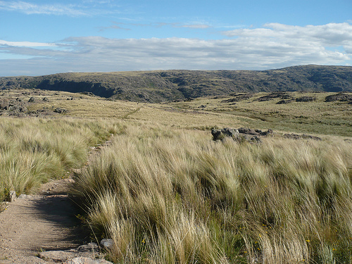
The Quebrada del Condorito National Park (legally Quebrada del Condorito National Park and Reserve) is located in the province of Córdoba, Argentina, 85 km west of the city of the same name and in the center of the Córdoba mountains. This national park was created in 1996. It is considered the third natural wonder of Córdoba. It has an area of 37,344 ha, of which 24,714 ha belong to the national park itself and 12,630 ha to the national reserve. Adjacent to both are the 146,000 ha corresponding to the Pampa de Achala provincial water reserve. In the national park itself, the lands are subject to the public domain of the National State, while in the national reserve they are under the private domain of individuals but subject to national jurisdiction, comprising 3 sectors: to the north the Estancia Santo Tomás, to the south the Atalaya and Viejo del Carmen ranches and to the east a part of the Yata establishment.
Characteristic
Despite being located close to the city of Córdoba
and tourist towns such as Villa Carlos Paz, Alta Gracia, Tanti and Mina
Clavero, the territory of the park has remained pristine in terms of
landscape due to its difficult accessibility until the beginning of the
21st century. Extensive cattle ranching has been practiced there since
colonial times, with negative results for the environment, due to the
overload of cattle, which caused intense erosion when the vegetation
cover became scarce and also due to trampling on this site of steep
slopes and soil. sandy.
The territory of this national park is
characterized by the high altitude of the upper floor of the Sierras
Grandes de Córdoba, with respect to the great Chacopampa plain that
surrounds it and gives it the conditions of a biogeographic island, this
"ecological island" has had intermittent flows of colonization of Andean
and Patagonian species (depending on climatic variations). As a result,
the area presents a great diversity of endemic species and subspecies,
both of plants and animals. This is one of the most outstanding features
of this area.
This park is an important site for condor sightings
(an Andean species that has suffered a marked population decline in the
20th century), whose easternmost distribution is in this region. In
Argentina, condor populations are stable and reintroduction programs are
being developed for this species in places where it has been extinct.
The boundaries of the national park are:
To the north: the new
path of the Altas Cumbres.
To the west: the properties that border
the peaks of Achala (Paso de las Piedras, La Trinidad, La Atalaya).
To the south: headwaters of the Yatán river (a river that stands out for
its beautiful Yatán ravine).
To the east: properties that border the
1500 m elevation (El Bosque, El Condorito, San Miguel).
Geology
and hydrography
The Sierras Grandes are made up of a granitic
batholith raised by the Andean orogeny. The relief, on the slopes,
presents steep slopes, and on the plateaus it presents numerous
geological fractures through which numerous streams and rivers
circulate, among which the ravine (or canyon) stands out through which
the fast-flowing and limpid Condorito River (tributary of the Second
River).
Climate
The climate in the area is temperate mountain,
but at the top of the mountain range it becomes cold, with a wide
temperature range between day and night and between summer and winter.
During winters (May to early August) snowfall is common. Another
characteristic phenomenon is the frequent lightning strikes in the
highest areas.
Fauna
The ravine that gives its name to the
area is a deep ravine, almost a geomorphological canyon, almost 800 m
deep, from whose upper edges it is possible to observe, at almost the
same level, the gentle gliding of the Andean condors. The denomination
has its origin in the old name Río de los Condoritos given by the
characteristic presence of a high proportion of juvenile condors in
these colonies. It is not a breeding site, but the adults take their
young there when they are able to fly, perhaps so that they learn to
forage in their adult lives. The 2006 census has indicated that the
population of such birds remains stable compared to 1996, with about 100
condors in this stream.
Until the beginning of the 20th century,
sightings of jaguars, guanacos, peccaries and serrano tuco-tucos
(Ctenomys pundti) were reported. Currently the main fauna consists (in
addition to the condors that give the park its name) of pumas, foxes of
the culpeo species and jotes. The fauna has some endemic species: two
amphibians (a toad and a escuerzo) that are in danger of extinction due
to the presence of the fontinalis trout, two reptiles (a green lizard
and a striped snake, both are typical of Achala) , the red fox has a
typical breed of these mountains, while among the birds several
exclusive species of the place have been recognized. The National Parks
Administration is carrying out a guanacos reintroduction project.
first inhabitants
The available evidence indicates the human
presence in the mountain area for 11,000 years. The Comechingones
inhabited the region until the 16th century when Colonization occurred,
and thousands of years ago the Ayampitines (that is, the members of the
archaeological culture -disappeared- called the Ayampitín Culture),
frequented these plateaus,5 establishing temporary camps for the hunting
of large mammals, abundant there, or of medium size such as the guanaco
and the pampas deer.
Management
By resolution No. 126/2011 of
the National Parks Administration of May 19, 2011, it was established
that the national park would be classified for administrative purposes
in the category protected areas of complexity II, for which it is headed
by a designated intendant, On which 4 departments depend
(Administration; Works and Maintenance; National Park Rangers;
Conservation and Public Use) and 2 divisions (Entry, Exit, and
Notifications Office and Desk; Human Resources and Training). The
administration has its headquarters in the city of Villa Carlos Paz.
Access roads
Provincial Route No. 34 (Ruta de las Altas Cumbres),
between the city of Villa Carlos Paz located in the Punilla Valley and
the incipient city of Villa Cura Brochero-Mina Clavero located in the
Traslasierra Valley. The main access to the national park is in its
northeast area through Paraje La Pampilla; there you enter by car to the
Visitor Center (park ranger's office).
Tours
There are
pedestrian paths and bike paths of various lengths and degrees of
difficulty. Considering the environmental and topographical factors, it
is advisable to consult the National Park Intendancy to have the
appropriate recommendations to safely enjoy this wild and lonely
landscape. There is signage on all trails. There are several wild
camping areas (without services) with access to drinking water from
springs.