Location: Tierra del Fuego Province Map
Area: 630 km2 (243 sq mi)
Info: Ruta Nacional 3, km 3047 Avenida San Martin 1395, Ushuaia
Tel. (02901) 421 315
Open: daily
Tierra del Fuego National Park is located in Tierra del Fuego
Province of Argentina. Tierra del Fuego National Park was created in
1960 and covers an area of 630 km2 (243 sq mi). The easiest way to
get to Tierra del Fuego National Park is by getting to a city of
Ushuaia, located 12 miles West of the park entrance. You can take a
car or a taxi and travel along National Route #3. You can also take
a train that runs along Southern Fuegian Railway (also known as the
Train of the End of the World). Its station is situated 8 km West of
Ushuaia. Additionally you can get to the park by taking a catamaran
from Ushuaia Bay with a harbor of Lapataia. It will take you to the
shores of the Beagle Channel that are often covered by colonies of
various species of penguins. It was named so by the crew of a
British ship HMS Beagle during its first hydrographic survey.
(Charles Darwin travelled on HMS Beagle during its second voyage
under command of captain Fitz Roy) British sailors encountered
Yaghan indigenous people who settled these land as early as 10,000
years ago.
Tierra del Fuego National Park is an important
landmark as it the finishing point of Pan- American Highway that
passes across the continent of South America. Its climate is fairly
rough through out a year. Strong winds and low temperatures make
this protected park as one of the most habitable. Particularly
autumn months, which are March, April and May in the southern
hemisphere are particularly unwelcoming as rain shower bound the
area.
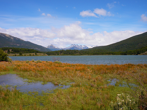
Tierra del Fuego National Park is located on the
shores of the Atlantic Ocean. Additionally it containts Roca and
Fagnano lakes with its unique biosphere. Fauna of the park include
beavers, rabbits, foxes, guanacos and other animals. However most of
travelers arrive in Tierra del Fuego National Park for bird
watching. Some of the species include ducks, condors, parrots,
shorebirds, blackbirds, cormorants, several species of penguins and
many other birds.
Organization and administration of the park
The park is subdivided
into zones, in each one of which is regulated which activities are
allowed according to the established preservation objectives. Of the
total of 63,000 ha that make up the park, only an area of 2,000 ha is
assigned to tourist use, the rest having the category of strict nature
reserve. Within the limits of the national park there are two private
properties, one of 322 ha and another of 2 ha.
The park is
managed by the National Parks Administration. There are numerous park
rangers located in different parts of the park who enforce current
regulations regarding activities allowed and not allowed in the park,
and guide tourists and visitors who travel through it.
By
resolution No. 126/2011 of the National Parks Administration of May 19,
2011, it was arranged that the national park be classified for
administrative purposes in the category protected areas of complexity I,
for which it is headed by a designated intendant , on which 6
departments depend (Administration; Works and Maintenance; National Park
Rangers; Conservation and Environmental Education; Public Use; Human
Resources and Training) and 2 divisions (Dispatch and Desk of Entrances,
Exits, and Notifications; Legal Affairs). administration has its
headquarters in the city of Ushuaia.
Tourist and recreation
activities
In summer, about a thousand people a day visit the
national park, accessing it in various ways.
Access
Vehicle
access
Access is from the city of Ushuaia, about 12 km east of the
park, through National Route No. 3. In fact, this route ends in the
Lapataia Bay sector of this national park. of his journey, which begins
in the distant city of Buenos Aires. From National Route 3, three
secondary roads originate: to the Pipo or Ajej River, to Zaratiegui Cove
and to Roca or Acigami Lake.
rail access
The most typical
means of transport for visitors to access the park is the so-called "End
of the World Train", which leaves from the End of the World station, 8
km west of Ushuaia. This is the final part of the line that linked the
prison of Ushuaia with the labor camps located in what is now the park.
maritime access
It is also possible to access the park by
embarking on a catamaran, which connects the port of the city of Ushuaia
with the pier at Lapataia Bay, sailing through the waters of the Beagle
Channel.
Climate
The climate of the park, according to the authors, belongs
to the subpolar oceanic, or humid Patagonian climate. Despite the fact
that temperatures are cold all year round, it has high Magellanic
forests. It has an average annual temperature of 5.7 °C and a low annual
thermal oscillation, which goes from -0.3 in July to 9.4 °C in January;
Temperatures above 15 °C in summer or below -8 °C in winter are rare.
The absolute temperature records are 29.4 °C (it happened in December)
and -25.1 °C (it happened in July). Such is the persistence of the cold
that in the middle of the austral summer there have been occasional
snowfalls, or temperatures of only -6 °C. Precipitation, which in winter
is usually in the form of snow, is distributed equally throughout the
year, adding a total of 524 mm, but, although it would seem meager, due
to the constant low temperature it becomes enough to turn it into a
park. of humid climate; The high average of days with some precipitation
-200 days a year- also helps for this, and the number of cloudy or misty
days is also high. Strong winds from the west quadrant, originating in
the Pacific, often hit the coasts of the protected area, which is why
the trees exposed to storms grow following the direction of the wind,
which means that, due to their shape, they are called «flag-trees» due
to the inclination they are forced to take.
Geology
The
geology of the Tierra del Fuego National Park area is the result of a
series of conformation and transformation processes that occurred over
millions of years, in particular the processes that have modified the
terrestrial strata through phenomena grouped in tectonics. of plates,
have been decisive in the conformation of the Andes mountain range. The
area was formed by erosion during the last glaciation, with various
deposits of material and moraines. Most of the lakes have shorelines
made up of boulders and coarse sand, or stone plates from the adjacent
mountains.
The Andes mountain range is the most important chain in the park,
which it crosses from west to east. Another outstanding chain is the
Sierra de Injoo Goiyin (or de Beauvior); and among the hills, the
Guanaco hill, in the Cordon del Toro, which has an altitude of 970
meters above sea level.
The heights range from sea level on the
coast of the Beagle Channel to 1476 meters above sea level on the
Vinciguerra hill.
Hydrography
Product of the rains and
snowfalls that are recorded in the area, and the melting in summer, the
park has a varied set of lakes and lagoons. Countless streams and rivers
are born from the top of the mountains, which are fed by the spring
thaw, and which flow into the lakes found in the park or directly on the
shores of the Beagle Channel.
The largest lake is Lake Fagnano
(also called Kami), in the northern sector of the park, although the
most visited is Lake Acigami (formerly called Lake Roca), cut from north
to south by the border with Chile. Among the most prominent rivers is
the Ajej River (formerly called the Pipo River).
coastal
morphology
The maritime coasts of the park are one of its greatest
attractions, since they are jagged, cliffs, outlined by trails that
allow access to panoramic points located in the most impressive sectors
of the sea coast. Numerous islands complete the coastal panorama,
especially in Lapataia Bay, without a doubt the latter is the greatest
attraction of its shores.
andean fauna
The animal that is most clearly associated with the
area is the Andean condor, whose wings have a wingspan of up to 3.3 m.
There are also troops of guanacos, it is an extremely agile and fast
camelid; It is the largest land mammal in the park, reaching up to 1.10
m in height; It is covered by a thick double coat that protects it.
Fauna of the open meadows
In the forests you can see the
Patagonian Fringillo, the Rayadito, the Austral Parrot or Cachaña, the
Patagonian Woodpecker with its black body and red head, the Thrush, and
the southernmost hummingbird in the world: the ruby hummingbird with
brilliant plumage. For its part, the southern rat lives in the
undergrowth, moving with small jumps or by short flights. A curious
inhabitant of the park is the largest race (endemic to the island) of
the red fox that is distinguished by its reddish head and legs, gray
back striped with black with a white belly and neck; It inhabits
deciduous forests, although it approaches camping areas in search of
food.
Flora
In the short grasslands, marshes, humid
wastelands, and open places near the roads, it is possible to observe an
important variety of birds, including the Patagonian whirlwind, the
bandurria baya, the tero and the cauquenes. In high watchtowers you can
see jotes and harriers. Given the cold climate there is not a great
abundance of insects. During the summer only a few horseflies cause any
nuisance.
freshwater aquatic fauna
In remote lacustrine
environments, in areas of thick vegetation lives a rare species of
native otter called huillín, which is in danger of extinction. It feeds
on small fish and molluscs. In the streams it is possible to observe the
kingfisher, while patiently waiting for their catch. Among the native
fish fauna of the park's lakes, the puyén stands out.
marine
fauna
Its coasts belong to the Channels and Fjords ecoregion of
southern Chile. In them the marine fauna is abundant, with the presence
of birds such as the black-necked cormorant, the southern oystercatcher,
Magellanic penguins, petrels, cook gulls, southern gulls, imperial
cormorants, Pacific steam ducks, carancas or sea cauquenes, mammals such
as sea lions of one and two hairs, sea otters, and dolphins.
Its waters are rich in fish, and various invertebrates such as mussels,
mussels and other molluscs, and crustaceans such as spider crabs and
especially the Patagonian spider crab, whose meat is famous for its
delicate flavor, becoming the typical culinary dish of the region.
Exotic animals
During the 20th century, specimens of fauna from
the northern hemisphere, such as the muskrat, the rabbit, and the
American beaver, were introduced to the island and have become
excellently acclimatized; the last two species cause serious
disturbances in this national park. The introduction of exotic trout was
extremely detrimental to native fish, which were predated by these
species. The lakes and lagoons of the park have a remarkable population
of salmonids. The most important species is the rainbow trout. Fishing
is regulated in the park.
Flora
andean mountain
The area
called Andean mountain is located above the level of 500 meters above
sea level, corresponding to the upper area of the hills. The area is
characterized by rocky massifs, extensions of loose stones (pedreros)
interspersed with sand, and small isolated meadows in the high mountain
valleys in the area where the streams that feed the melting ice
converge.
Environmental conditions are very rigorous, with the
area exposed to snowfall and blizzards throughout the year, and humidity
is low. Exposure to strong winds blowing continuously from the west and
solar radiation contribute to making this environment quite
inhospitable. The area remains covered by a layer of snow from fall to
spring; at higher altitudes there is also eternal snow.
For all
these reasons, the vegetation is low, and develops mainly in hollows or
areas that offer shelter from climatic conditions. It is during the
period from December to March that the existing vegetation recovers
energy to face the harsh conditions that prevail the rest of the year,
and that is when the vegetation offers showy flowers that compete for
the attention of the walker. The small prairies develop in mallineous
terrain with the presence of species of compost, mosses, and grasses.
Likewise, lichens of bright colors develop on the rocks. Already in
lower altitude areas there are "stumpy" lenga groves, since due to the
action of the snow load on them, their height does not exceed 2 to 3 m.
magellanic forest
The forest starts from sea level and reaches 450
m in height. It is the Magellanic Forest. The forests represented are:
the deciduous forest with a predominance of whose characteristic species
are the lenga, and the ñirre and, in more humid sectors and protected
from the winds: the evergreen forest of coihue magallánico or guindo,
canelo, Maytenus magellanica, and notro, along with thickets of chilco
or aljaba, michay, calafate, black forest, and Magellanic tundra in
areas of poor drainage. In the undergrowth of the forest you can find
some delicate species of orchids and ferns.
marine vegetation
The waters that bathe the coasts of this park are notable for having
submerged forests of giant cachiyuyos, a brown algae of enormous
proportions, which supports a rich marine biodiversity.
Bioindicators
Among the Fuegian species we can observe different
organisms that are used as bioindicators, these are species/assemblies
that with their mere presence indicate certain environmental conditions.
They are organisms that are very sensitive to air pollution, that is, to
the presence of certain harmful substances in the air, deciphering any
current (or past) phenomenon or event related to the study of an
environment. For this reason they are used as indicators of the degree
of pollution that exist in cities.17
On the authorized trails of
the Tierra del Fuego National Park, the following species can be easily
observed:
Usnea barbata "Old man's beard"
Parmelia "shield
lichen": Habitat: Bark, decomposing wood or rocks, easily visible in
Tierra Del Fuego National Park.
Menegazzia "tree flute lichen"
Xanthoparmelia "rock frog lichen"
Caltha Sagittatta