Location: Djémila
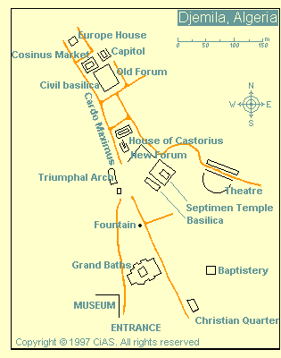
Map
Former name: Cuicul, Curculum
Inhabited: 1st- 6th century
Tel.
036 945 101
Entrance Fee: DA20, student DA10
Open: 9am- 12pm,
1:30- 5:30pm
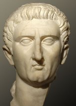
Emperor Nerva (96 - 98 AD)
Djémila or Cuicul as it was known back then, was constructed by the Romans during reign of emperor Nerva (96 - 98 AD). The site was chosen at the confluence of the two rivers. Djemila is an extensive ancient Roman town that was added to a UNESCO World Heritage Site List. Unlike many Roman cities in Europe, Djemila was largely abandoned and hence it escaped a fate of vandalism by the local population. The city was inhabited by farmers and wheat traders that sold grains to all corners of the Roman Empire. In the ancient times Northern Algeria had much milder climate, that was perfect for growing crops without a threat of a sudden freeze. Residents of Djemila enjoyed their status as a major food supplier.
Elevation and Topography
The ancient Roman settlement and modern
village perch on a narrow, triangular rocky spur (or ridge) at an
elevation of about 900 m (2,953 ft) above sea level. This strategic high
ground rises sharply from the surrounding terrain, creating a naturally
fortified plateau with steep slopes and deep ravines on multiple sides.
The broader area around Djémila has an average elevation of roughly 869
m (2,851 ft), with local relief ranging from lower valleys around 474 m
(1,555 ft) to higher ridges reaching up to about 1,454 m (4,770 ft).
The topography is distinctly rugged and hilly: the site is constrained
by the natural contours of the mountain landscape, forcing the Roman
urban planners to adapt their typical grid layout. Streets align with
the slope rather than a strict orthogonal plan, and the overall
settlement hugs the contours of the spur. Deep ravines bound the
east-west streets (decumani), while a long north-south Cardo Maximus
gently slopes along the plateau’s length. The theater was built outside
the original walls due to space limitations—an unusual feature for Roman
towns. This integration of architecture into the steep, uneven terrain
is one of the site’s most celebrated geographic adaptations.
Hydrology: Wadis and Confluence
Djémila’s position is dramatically
defined by its location at the confluence of two mountain torrents (wadi
or oueds): the Wadi Guergour and the Wadi Betame. These seasonal rivers
carve steep valleys and ravines that flank the rocky spur on two sides,
enhancing its defensive qualities and creating a striking visual
setting. The wadis flow from higher Atlas ridges, providing water
resources historically used for agriculture (cereals, olives) while also
posing flash-flood risks in winter. The surrounding valleys and gorges
add to the site’s dramatic relief and isolation.
Climate
At
900 m elevation in the Tell Atlas, Djémila experiences a highland
Mediterranean climate (Köppen Csa or transitional BSk), cooler and more
variable than the coastal plain but drier than the wetter Kabylie ranges
to the north. Summers are hot and dry (July averages around 29–36°C
highs), while winters are cooler and wetter (February lows near 3–4°C,
with occasional frost or light snow at this altitude). Annual
precipitation is moderate, estimated at 400–600 mm, concentrated in
winter months (wettest around March), with very dry summers. This regime
supports seasonal wildflowers that carpet the hills in spring and
sustains limited agriculture in the surrounding valleys. Sirocco winds
can bring dust from the south in summer.
Vegetation, Landscape,
and Land Use
The immediate setting features green, rolling hills
typical of Petite Kabylie, covered in Mediterranean maquis shrubland
(including wild olive, Aleppo pine, and aromatic herbs). In spring, the
landscape blooms with yellow, white, and purple wildflowers woven among
the ruins and hillsides. Farther views reveal the higher, sometimes
snow-capped peaks of the Atlas Mountains, while the lower valleys
support traditional farming of cereals and olive groves—key to the Roman
colony’s prosperity. The terrain’s ruggedness limited large-scale
development but provided natural defense and scenic beauty (the name
“Djémila” means “beautiful” in Arabic).
Broader Geographic
Context and Significance
Djémila lies in Algeria’s northern
mountainous zone, part of the Tell Atlas chain that runs parallel to the
Mediterranean and forms a natural barrier between the coast and the high
plateaus/Sahara. This location was strategically chosen by the Romans in
the late 1st century AD as a military garrison to control mountain
passes and trade routes in Numidia. The site’s singular defensive
position—elevated, constricted by rivers and ravines—made it nearly
impregnable and allowed remarkable preservation of its Roman layout
despite the geophysical challenges. Today, the surrounding landscape
remains largely rural and verdant compared to the arid south, offering
visitors panoramic vistas of integrated ancient ruins amid dramatic
mountain scenery.
Pre-Roman and Foundation (1st Century AD)
Evidence of a pre-Roman
Berber/Numidian settlement exists on the site, though details are
sparse. The Romans founded Cuicul as a military garrison and veteran
colony around 96–98 AD during the reign of Emperor Nerva (or possibly
early under Trajan). It was initially settled by veterans from Italy,
part of Rome’s strategy to secure inland Numidia after coastal control.
The defensive position—on a high, narrow plateau with natural
barriers—was ideal for a frontier outpost.
Early Cuicul followed a
classic Roman grid plan centered on a forum, with the Cardo Maximus
(north-south main street) and Decumanus Maximus (east-west) as axes. It
included essential public buildings: a Capitolium (temple to Jupiter,
Juno, Minerva), curia (senate house), civil basilica, and macellum
(market). Two gates marked the ends of the Cardo. Aristocratic houses
featured early mosaics. The town was fortified with ramparts, and a
temple to Venus Genetrix stood nearby.
Growth and Prosperity (2nd
Century AD)
From a military outpost, Cuicul evolved into a prosperous
trading and agricultural center. Its economy relied on cereals, olive
oil, and farms in the surrounding fertile highlands. Population grew
steadily, supported by trade routes linking the Mediterranean coast to
the interior. By the late 2nd century, the original settlement could no
longer contain the expanding population.
Key early monuments included
the theater (completed around 161 AD under Antoninus Pius, built by
local benefactors Caius Julius Crescens and Caius Julius Didius
Crescentianus). Unusually, it was placed outside the walls due to the
steep eastern ravine slope; it seated about 3,000 (for a city population
estimated at around 10,000 at its peak). The Great Baths (Baths of
Caracalla) were constructed in 183 AD under Commodus.
Severan
Expansion and Golden Age (Early 3rd Century AD)
The most dramatic
growth occurred around the beginning of the 3rd century under the
Severan dynasty (especially Septimius Severus and Caracalla). Old
ramparts were partially demolished to create a “new town” or Severan
quarter on the southern hill slope. A large porticoed square (Severian
Forum or New Forum) separated old and new sections, crossed by the
extended Cardo Maximus.
Notable monuments from this era include:
Arch of Caracalla (216 AD): A triumphal arch dedicated to Emperor
Caracalla, his mother Julia Domna, and deceased father Septimius
Severus. It served as the western gateway for travelers from Mauretania
and featured elaborate decoration, including statues and unique square
aedicules.
Temple of Gens Septimia (c. 229 AD): A grand temple on a
high podium dedicated to the Severan imperial family (Septimius Severus
and Julia Domna), with colossal statues (heads now in the site museum)
and an arched cella entrance.
A new market, civil basilica, and
additional private dwellings.
These expansions reflected the
city’s wealth and imperial favor—Septimius Severus, born in Leptis Magna
(Africa), was popular in Numidia. Cuicul had its own senate and forum,
functioning as a fully Romanized municipium.
Christian Era and
Late Antiquity (4th–5th Centuries AD)
Christianity took root early,
with persecutions noted in the 3rd century. By the 4th century, it
flourished, and an ecclesiastical quarter developed south of the city in
an area called “Christian.” This included one of the largest
Paleochristian complexes in North Africa: a cathedral, church,
baptistery, auxiliary rooms, baths, and a peristyle house. Three
basilicas and a baptistery highlight Cuicul’s religious importance.
Bishops of Cuicul participated in major councils:
Pudentianus
(Council of Carthage, 255 AD, on heretical baptism).
Elpidophorus
(348 AD).
Cresconius (411 AD, Catholic-Donatist conference).
Crescens (484 AD, under Vandal king Huneric).
Victor (Second Council
of Constantinople, 553 AD).
Cuicul even produced notable
Romanized African officials, such as governors of Britannia,
Mesopotamia, Egypt, and Numidia. A 4th-century basilica replaced an
earlier pagan temple (possibly to Frugifer, god of agriculture),
signaling the shift from traditional worship.
The city retained
impressive mosaics depicting mythological scenes (e.g., Lycurgus and
Ambrosia) and daily life, many now in the Djémila museum.
Decline, Invasions, and Abandonment (5th–7th Centuries AD)
Cuicul
fell to the Vandals in 431 AD. It experienced a brief renaissance under
Byzantine rule in the 6th century, when Emperor Justinian I reinforced
walls and some buildings. However, the city was gradually abandoned by
the late 6th century and fully deserted after the Arab (Muslim) conquest
of the Maghreb in the 7th century. The new rulers did not resettle the
hilltop site, instead naming the ruins Djémila for their beauty.
Rediscovery and Modern Archaeology
The ruins lay largely untouched
for over a millennium. French forces noted them during the 1839
expedition to eastern Algeria, but systematic excavation began in 1909
(triggered by modern road construction) and continued intensively until
1957 under French archaeologists. Much of the Severan town was uncovered
and partially reconstructed. In 2009, the Zamani Project created 3D
digital documentation of key structures (baptistery, Arch of Caracalla,
market, temple, theatre).
Djémila was inscribed as a UNESCO World
Heritage Site in 1982 under criteria (iii) and (iv): it bears
“exceptional testimony to a civilization which has disappeared” and is
an “outstanding example of a type of architectural ensemble illustrating
a significant stage in Roman history of North Africa,” especially for
its masterful adaptation of Roman urbanism to a mountainous site.
The
site includes remarkably intact vestiges: two fora, temples, basilicas,
arches, a theatre, baths, houses with mosaics, streets, and defensive
elements. Conservation faces threats from earthquakes, erosion, and
modern pressures, but the ruins remain surprisingly well-preserved.
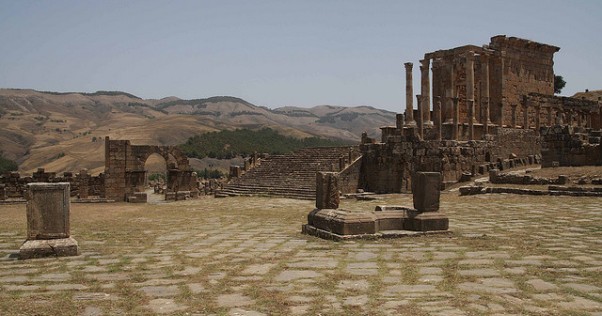
The Original Roman City (1st–2nd Centuries CE)
The core settlement
followed classic Roman grid planning but squeezed onto the constrained
spur, with the Cardo Maximus (main north-south street) running the
length of the old town between two gates. Paved in stone and lined with
columns, it still evokes the bustle of ancient daily life.
At its
heart lies the Old Forum (Forum of the Harsh), a large paved public
square that served as the political, religious, and social center.
Surrounding it are key civic buildings:
The Capitoleum
(Capitoline Temple), dedicated to Jupiter, Juno, and Minerva — the trio
of state gods. This elevated temple complex, reached by steps, dominated
the forum and symbolized Roman imperial authority.
The Curia (senate
house), where local magistrates met.
The Civil Basilica and Basilica
Julia, used for legal and commercial proceedings.
Nearby stands
the elegant Temple of Venus Genitrix (Temple of Venus the Ancestress),
one of the finest small temples on site, with well-preserved columns and
decorative elements honoring the goddess linked to Julius Caesar’s
lineage.
Private houses of wealthy residents line the streets; many
featured peristyle courtyards and floors covered in intricate mosaics
depicting myths (e.g., Orpheus, hunting scenes) and everyday life.
Several bath complexes, including the Grand Baths, offered hypocaust
heating systems, pools, and exercise areas — essential Roman amenities.
The Severan Expansion (Early 3rd Century CE)
By the reign of
Septimius Severus (the first North African-born emperor) and his son
Caracalla, the city outgrew its original walls. A new southern district
was added, marked by grand imperial monuments.
Arch of Caracalla
(216 CE): This 12.5 m (41 ft) high triumphal arch, with Corinthian
columns and rich carvings, served as the monumental gateway into the new
quarter. It honors Emperor Caracalla, his mother Julia Domna, and his
father Septimius Severus. It remains one of the site’s most iconic and
photogenic landmarks.
Severan Forum (also called Place des Sévères or
New Forum): A large, porticoed square that connected the old and new
towns. It functioned as an expanded civic space.
Temple of Gens
Septimia (Temple of the Severan Family, dedicated c. 229 CE): A massive
temple reached by a grand staircase, fronted by rows of towering
Corinthian columns. It was dedicated to the imperial cult and the
Severan dynasty.
Macellum (Market of Cosinius): A commercial
marketplace with shops and stalls arranged around a central courtyard —
evidence of Cuicul’s thriving trade economy.
Roman Theatre: Built
outside the walls on a natural hillside slope (completed under Antoninus
Pius), this 3,000-seat theatre is remarkably well preserved. Its
semicircular seating, stage area, and acoustics still impress visitors;
the mountain views from the upper tiers add to the experience.
The Christian Quarter (Mid-3rd–6th Centuries CE)
Christianity took
root early here. In the upper part of the city, a dedicated quarter
includes some of North Africa’s largest Paleochristian structures:
A
large cathedral (or main basilica) and a second church.
An impressive
baptistery (one of the biggest of the period), with a sunken font and
surrounding mosaics.
A small chapel.
These buildings reflect
the city’s transition from pagan to Christian worship before the Vandal
invasion (431 CE) and brief Byzantine revival in the 6th century. The
site was largely abandoned after the Arab conquest in the 7th century.
The Museum of Djémila
No visit is complete without the on-site
museum (just uphill from the ruins). Its walls and floors are covered
with dozens of original mosaics removed from houses and public buildings
— vivid scenes of mythology, wild animals, hunts, and daily life.
Statues, inscriptions, and artifacts provide context. The museum itself
feels like a jewel box of Roman artistry.
Visiting Tips and
Overall Impression
Djémila’s magic lies in its setting: the ruins
feel alive against the rugged mountains and wadis, far more intimate
than flatter sites like Timgad. A full visit takes 2–4 hours on foot
(wear sturdy shoes — paths are uneven). The best light is morning or
late afternoon. Combine it with the museum for the full story.
Djémila stands as a testament to Roman cultural and architectural influence in North Africa, showcasing how urban planning was tailored to local geography while maintaining imperial standards. It represents the frontiers of the Roman Empire, serving as a military, economic, and later religious center that integrated local populations with Roman colonists. The site's mosaics and structures provide insights into daily life, mythology, and the transition to Christianity, with notable Romanized Africans originating from Cuicul. Today, it is a titular see of the Catholic Church, underscoring its enduring ecclesiastical legacy. Inscribed as a UNESCO World Heritage Site in 1982 under criteria iii (bearing unique testimony to a cultural tradition) and iv (outstanding example of a type of building or architectural ensemble), Djémila covers 0.3 square kilometers and is celebrated for its preservation and beauty.
Djémila attracts visitors for its exceptionally preserved ruins, offering opportunities to explore Roman history through guided tours of key sites like the theatre, arches, temples, and Christian quarter. The site's mosaics and panoramic mountain views enhance its appeal for photographers and history enthusiasts. It is accessible from Algiers in about 3 hours and 45 minutes via the A1 road, and hiring a guide is recommended for in-depth understanding. While specific opening hours and fees are not detailed, the site supports educational visits, with nearby accommodations in Sétif for extended stays. Activities include walking tours along ancient streets, viewing artifacts on-site, and appreciating the blend of Roman architecture with natural landscapes.
Conservation at Djémila involves ongoing archaeological work and restoration to maintain its structures against environmental wear and urban encroachment. The Zamani Project, in collaboration with the University of Setif and funded by the South African National Research Foundation, conducted spatial documentation in 2009, digitally preserving sites like the Baptistry, Caracalla Gate, Market, Septimius Severus Temple, and Theatre. As a UNESCO site, it benefits from international monitoring, though challenges include natural erosion from the mountainous climate and the need for continued excavations. Efforts focus on balancing tourism with preservation to prevent damage to fragile mosaics and ruins.
Standout features include the fine mosaics throughout the site, illustrating Roman artistry; the well-preserved bath complex; and the Christian buildings, such as the cathedral and baptistery, which highlight religious shifts. The Arch of Caracalla and the theatre offer iconic views, while the overall layout demonstrates innovative adaptation to the terrain. Although no major on-site museum is specified, the ruins themselves serve as an open-air exhibit, with some artifacts potentially housed in regional institutions. The site's "beautiful" moniker aptly captures its harmonious blend of history and scenery.