Location: Blida Province Map
Area: 260 km2
Tel. (213.025) 41 64 61
Fax (213.025) 41 63 63
Email: chrea-parc@ifrance.com
UNESCO site
Chrea National Park (الحديقة الوطنية الشريعة) situated in the north Algeria covers 260 square kilometres of Tell Atlas range. Unusual terrain and climate creates an unique isolated habitat for different biospheres that coexist here. Over 1200 of different species call Chrea National Park their home. Many of the plants, animals and birds are endemic to the region. Local people take particular pride in magnificent raptor species that are associated with strength and agility in the local folklore. Although few farmers do live on the territory of the protected biosphere they do minimal damage to the surrounding area. With tourist money flowing in they see no sense in hunting or logging magnificent Atlas cider (Cedrus atlantica) forests that are wide spread in the area.
Besides hiking and camping the area is also famous for its Chrea Skiing Station. It is one of the few places in Africa that even sees snow and certainly one of the few skiing destinations on the continent. It is a general rule whether you are hiking or skiing keep yourself warm and expect decreased temperatures especially at night. Another popular destination is grotto of Chiffa that harbors Barbary Macaque or Barbary Apes (Macaca sylvanus) as they commonly referred. This endemic specie is on the endangered list and National Park is one of the last places there you will see one up close.
Ancient and Pre-Colonial Roots
The rugged mountainous terrain of
the Blidean Atlas has been inhabited by Berber (Amazigh) communities for
millennia. These indigenous groups left traces through traditional
pastoral practices, rock carvings, and settlements adapted to the
cedar-covered ridges and gorges (such as the Chiffa gorges and Lake
Dhaya at Tamesguida). The area’s forests provided resources like timber,
game, and medicinal plants long before modern boundaries existed.
During the Roman era (roughly 1st–5th centuries CE), North
Africa—including the Blida region—was part of the Roman provinces of
Mauretania and Numidia. While no major Roman cities lie directly inside
today’s park boundaries, the broader Chréa Valley and surrounding Atlas
foothills feature remnants of Roman roads, fortifications, and influence
tied to agricultural and military networks. Nearby sites (e.g., in the
Mitidja plain or toward Tipaza/Cherchell) reflect this era’s impact,
with the mountains serving as natural barriers and resource zones.
By
the 19th century (pre-French conquest), the cedar forests had already
suffered significant deforestation due to local needs and early colonial
pressures, setting the stage for later protection efforts.
Colonial Era (French Algeria): Early Protection and Tourism Development
(Late 19th–1950s)
French colonial authorities began systematic
interest in the Blidean forests in the late 19th century amid widespread
deforestation. Proposals in 1882 and 1893 to repurchase and reforest
land were initially rejected, but the 1903 forest law and 1910
reforestation service led to expropriations and planting programs.
The modern conservation story starts in 1911–1913:
In 1911,
Blida’s municipal council pushed for a planned summer resort (estivage)
in the Atlas to curb unplanned building and further deforestation.
1912 saw the construction of the first forest house (Hakou Feraoune) and
reforestation of hundreds of hectares.
In 1913, the forest was
officially declared the “Parc National de Chréa” under the impetus of
the Société d’histoire naturelle de l’Afrique du Nord. This was one of
Algeria’s earliest protected areas, initially focused on the cedar
groves (over 3,000 ha on the crest).
A gubernatorial decree on 3
September 1925 formally confirmed and expanded the designation.
Throughout the 1920s–1930s, colonial authorities built infrastructure:
roads (completed to the Col de Chréa by 1924), multiple forest houses,
refuges, and the Hôtel des Cèdres (originally a 1916 skier shelter).
Skiing began in the 1910s–1920s, with lifts and pistes developed by the
1940s–1950s. The area was marketed as the “Algerian Alps” for European
settlers (Pieds-Noirs), attracting thousands for winter sports, summer
escapes, and motor races. By the 1950s, hundreds of chalets existed, and
the station saw record crowds (e.g., 100 buses and 1,000 cars in one
1953 weekend).
Reforestation countered erosion (e.g., major works in
the 1940s via the D.R.S. service, planting thousands of trees and fruit
orchards). However, the park was largely oriented toward settler
recreation, restricting traditional Berber pastoral access. Heavy
snowfall events (1935–1936, 1944) and floods highlighted the area’s
climate variability.
Algerian War of Independence (1954–1962): A
Hidden Revolutionary Role
During the war against French rule, Chréa’s
remote ski station and cedar forests provided cover for the Front de
Libération Nationale (FLN). A secret FLN base operated there, used for
clandestine meetings and logistics. Frantz Fanon—the influential
Martinican psychiatrist and revolutionary theorist who worked in
Blida—frequently visited the Chréa area under the guise of leisure or
medical trips; these excursions facilitated covert FLN activities. His
experiences in the region contributed to his writings on decolonization
(e.g., The Wretched of the Earth). The 1956 creation of a new Chréa
commune and military presence reflected the escalating conflict; by
1962, many European residents and chalets were abandoned as Algeria
gained independence.
Post-Independence: Formal National Park
Status and Modern Protection (1962–Present)
After 1962, the Algerian
state inherited the colonial protected zones but faced immediate
challenges: depopulation of the resort, infrastructure decay, and
pressure on natural resources. In the 1970s–early 1980s, conservation
efforts intensified amid growing awareness of biodiversity loss.
On
23 July 1983, Decree No. 83/461 officially established the Chréa
National Park as a public administrative institution under the Ministry
of Agriculture and Rural Development (Direction Générale des Forêts).
This expanded the protected area significantly to 26,587 ha, overlapping
multiple wilayas and shifting focus from tourism-centric to biodiversity
conservation. (Some English sources cite 1985, likely referring to
operational implementation.) The park’s mandate emphasized protecting
cedar forests, endemic flora, and fauna while allowing sustainable uses
like regulated hiking and limited local resource collection.
Key
milestones:
2002 (or 2003 per some official records): Designated a
UNESCO Man and the Biosphere (MAB) Reserve. This international
recognition highlighted its role as a “poumon” (green lung) for the
Algiers region, buffering the Mitidja plain from steppe climates and
supporting ecosystem services like water purification and recreation.
The park now hosts over 1,150 plant species (including Atlas cedar, holm
oak, cork oak, Aleppo pine) and 658 animal species (notably the
endangered Barbary macaque Macaca sylvanus in the cedar groves, plus
lynx, hyenas, eagles, and vultures). It represents ~34–36% of Algeria’s
flora and 23–25% of its fauna.
Contemporary History and
Challenges
Since the 1980s, Chréa has evolved into a major ecotourism
and winter sports destination (skiing remains popular during rare snowy
winters). Annual visitors reach into the millions, supporting local
economies but creating pressures (overcrowding, waste, fire risks). The
1990s civil war (“Black Decade”) limited access and impacted
conservation, though the park largely retained its core forests. Today,
management balances protection with sustainable tourism, scientific
research, and community involvement (e.g., arbutus berry picking, guided
hikes).
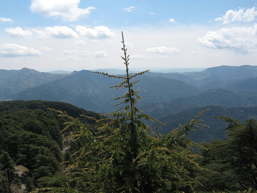
This Park is one of the many North African places, more or less effectively protected, where one can better observe the original appearance and understand more deeply the natural environment of the mighty Maghrebian mountain range which goes by the name of Atlas. It is a vast system of reliefs, which transversally marks the whole of Northern Africa, from Morocco to Algeria and Tunisia, which corrugated in the Alpine age and is similar to the Alps also due to a whole series of flora-faunal characteristics. It culminates in the Moroccan High Atlas with the sacred peak of Toubkal, at 4165 m, and overall constitutes a privileged, green and varied oasis in the arid monotony of the surrounding sub-desert lands. Even if its flora and fauna have been the subject of exploitation and destruction since very ancient times - and thus the Berber lion, the leopard, the lynx and many other large animals have disappeared forever - the Atlas still represents the extreme refuge for most of the plants and animals that have survived to the present day: this is the case of the Barbary monkey, or Barbary monkey (Macaca sylvanus), which reaches from the Atlas to the extreme tip of Europe, on the Strait of Gibraltar.
The Chréa National Park includes the highest part of the Chréa Mountains, culminating at 1550 m, and the Sidi Abdelkader peak of 1629 m, of the suggestive mountain chain that forms a very distinct sector of the Tellian Atlas immediately south of Blida. The appearance is suggestive, almost alpine, unexpected in Northern Africa where, a few kilometers away, lie sunny and parched territories. The base rock consists of characteristic black shale formations, which add to the interest of the landscape. What strikes the observer most, however, is the vegetation, majestic and imposing, and above all the presence of splendid forests of Atlas cedar (Cedrus atlantica), the most representative tree of the North African mountains, to the point that for many the area is known simply as "cedar park" (although it is certainly not the only Algerian park to host this essence). The air is filled with the smell of resin and the meadows are strewn with an extraordinary carpet of wild flowers in spring, while in autumn mushrooms of various species abound. Accompanying the cedar forest is a lower layer of holm oak, nor is there any shortage of other interesting trees and shrubs such as yew, holly and barberry.
The fauna, although not very rich, presents some reasons of interest especially due to the presence of showy mammals, such as the wild boar and the jackal. But the birds are much more numerous, among which insectivores stand out, and it is easy to observe magpies, jays and hoopoes of various species, while the encounter with birds of prey and vultures, once very frequent, is now a rare fortune. Even the entomological fauna preserves endemisms and peculiarities of considerable interest.