Location: Kabylia Map
Area: 82.25 km2
Djurdjura National Park (Parc National du Djurdjura, or PND) is
one of Algeria’s most iconic protected areas, located in the heart
of Kabylia (Grande Kabylie) in the northern Tell Atlas Mountains. It
straddles the provinces of Tizi Ouzou (to the north) and Bouïra (to
the south), covering approximately 185 km² (or about 18,550–20,150
ha depending on sources) of rugged limestone karst terrain, deep
gorges, dense cedar and pine forests, caves, and alpine-like
landscapes rising to 2,308 m at the summit of Lalla Khédidja.
The
park’s history is inseparable from the long human story of the
Djurdjura Range itself—a mountain chain that has served as a natural
fortress, cultural heartland, and site of resistance for the Kabyle
(Amazigh/Berber) people for millennia—while its formal protection
reflects layers of colonial exploitation, scientific curiosity,
post-independence reclamation, and modern conservation efforts.
Djurdjura National Park (Parc National du Djurdjura) is a striking
mountainous protected area in the Kabylie region of northern Algeria,
forming a core part of the Djurdjura Massif within the Tell Atlas
mountain system. It lies roughly 30 km southeast of Tizi Ouzou (to the
north) and 50 km south of the Mediterranean coast, straddling the
provinces (wilayas) of Tizi Ouzou and Bouïra. Coordinates center around
approximately 36°28′N 4°15′E.
The park covers about 185–201.5 km²
(roughly 18,500–20,150 hectares), established as a national park on 23
July 1983 and later designated a UNESCO Biosphere Reserve in 1997. It is
one of Algeria’s most iconic high-elevation landscapes, often described
as a “dinosaur skeleton” or arched “wall” rising dramatically from the
surrounding lowlands. The name “Djurdjura” (or Jjerjer in Kabyle)
translates to “great cold” or “elevation,” reflecting its harsh alpine
character; Romans called it Mons Ferratus (“Iron Mountain”) due to its
mineral-rich soils and rugged resistance.
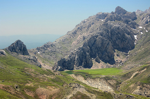
Topography and Relief
The park’s defining feature is the Djurdjura Range—a crescent-shaped,
east–west oriented karstic limestone chain approximately 50 km long and
10–12 km wide. Elevations range from about 800 m on the lower slopes to
a maximum of 2,308 m at Lalla Khedidja (also known as Tamgut Aâlayen),
one of Algeria’s highest peaks and the highest in the Tell Atlas. The
massif includes at least 14 named summits, such as Ras Tamedouine (2,305
m), creating a series of jagged ridges, plateaus, and escarpments.
The topography is highly asymmetric:
Northern face: Steep,
near-vertical escarpments with dramatic glacial cirques, deep gorges,
valleys, potholes, fissures, and cliff faces sculpted by ancient ice
action. These form imposing rock walls and incised channels.
Southern
slopes: Gentler and more accessible, blanketed in dense forests that
transition into alpine meadows at higher elevations.
A notable
gateway is the Tikjda Plateau (around 1,475–1,500 m), offering panoramic
views and access to higher trails. The overall relief is rugged and
dissected, with deep river valleys aligned along tectonic faults,
creating a complex mosaic of peaks, canyons, and plateaus.
Geology and Landforms
The Djurdjura Massif belongs to the internal
zones (Kabyle basement) of the Maghrebides, part of the broader Alpine
orogeny that formed peri-Mediterranean chains during the Tertiary
period. Uplift occurred primarily in the late Tertiary to early
Quaternary (ca. 5.2–0.9 million years ago), building on older Jurassic
and Triassic limestone sequences (ca. 140–200 million years old)
deposited in the ancient Tethys/Mésogée basin. The bedrock consists of
crystalline metamorphic massifs and Paleozoic sedimentary rocks with
limited metamorphism.
This has produced one of North Africa’s premier
karst landscapes:
Soluble limestone bedrock dissolved by water
over millennia, forming dolines (sinkholes), poljes, avens (shafts),
canyons, and an extensive subterranean network.
Over 40 documented
cavities, including spectacular caves and gouffres (deep pits). Notable
examples: Gouffre du Léopard (>1,175 m deep), Gouffre de Boussouil (>960
m), Anou Ifflis (one of Africa’s deepest), and Anou Boussouil (over 3 km
long).
Surface karst features include bare rocky expanses, ridges,
and cryoclastic (freeze-thaw) weathering that enhances the dramatic,
eroded appearance.
The combination of karst processes with past
glaciation (evident in northern cliff polishing and cirques) and
tectonic fracturing creates a “foisonnement géologique” (geological
abundance) unique in the region.
Hydrology
The park’s karst
geology dominates its water systems, creating a complex underground
aquifer network with rapid infiltration through fractures and conduits.
Surface drainage is limited; much water flows subterraneously before
emerging as rare vauclusian springs (powerful, cave-sourced
resurgences). The park is well-watered despite the Mediterranean
climate, thanks to high orographic precipitation.
Key features
include:
Numerous springs and streams feeding into the Wadi Sébaou
River basin (drainage area ~2,500 km²), whose tributaries (e.g., Aïssi,
Boughdoura, Acsif N’Boubhir, Sebaou Rabta) originate in the massif and
flow northward to the Mediterranean.
Lake Agoulmim, Algeria’s only
true high-mountain lake (around 1,700 m elevation, near Tikjda),
sustained by groundwater seepage and seasonal snowmelt.
Seasonal flow
regimes: high winter discharges from rainfall/snowmelt, reduced baseflow
in dry summers.
Climate
Djurdjura experiences a Mediterranean
mountain (orobiome) climate with strong altitudinal gradients. Lower
elevations (below ~1,500 m) are milder and semi-humid; higher zones
become cooler and more continental. Annual precipitation averages 1,000
mm park-wide, rising to 1,600–2,200 mm on upper northern slopes due to
orographic lift, mostly falling October–April. Summers (June–September)
are hot and dry (up to 30°C at lower altitudes, four months of drought),
while winters bring freezing temperatures (down to 0°C or below) and
snow cover lasting up to four months on peaks above ~1,800 m.
This
creates diverse microclimates and supports the park’s role as a
“sentinel” for climate-change monitoring in North African mountains.
Vegetation and Land Cover (Geography–Ecology Interface)
The
elevational and topographic diversity drives clear vegetation zonation:
Lower slopes → mixed oak, pine, and juniper shrublands/forests.
Mid-to-upper elevations → iconic Atlas cedar (Cedrus atlantica) groves
(dense on southern slopes, sometimes in thickets or along rivulets).
Highest zones → rupicolous (rock-dwelling) grasslands, alpine meadows,
and bare karst.
Forests cover much of the terrain, contrasting
with exposed limestone ridges and gorges. The isolated “continental
island” effect from the massif’s geography promotes high endemism.
Etymology and Deep Cultural Roots
The name “Djurdjura” (Arabic:
جرجرة; Berber/Kabyle: Adrar n Jerjer or Jjerjer) comes from the Kabyle
word meaning “great cold” or “elevation,” derived from the ancient
compound Jer n Jer (“mountain of the mountains”). Romans knew the range
as Mons Ferratus (“Iron Mountain”), referring both to the iron-rich
soils and the fierce resistance of the Kabyles to Roman annexation.
Locally, inhabitants are called Mmis n’Djerdjer (“children of the
Djurdjura”), and the name appears in Kabyle cultural expressions,
including a female music group. This linguistic and symbolic link
underscores the park’s role as a living embodiment of Kabyle identity.
Prehistoric, Ancient, and Pre-Colonial Human History
Human
presence in the Djurdjura/Kabylia region dates back tens of thousands of
years. The area was part of the Kingdom of Numidia (202–46 BCE). A
notable 4th-century CE revolt provides some of the earliest written
records of local resistance.
The mountains were never fully
subdued by successive powers:
Romans
Arab conquerors
Ottomans
(under the Regency of Algiers, 15th–18th centuries, when much of Kabylia
remained effectively independent)
Ibn Battuta crossed the range
en route to Béjaïa in the 14th century. Kabyle villages clung to steep
slopes, practicing terraced agriculture and maintaining distinct Berber
language, customs, and social structures (e.g., village assemblies or
tajmaât). The rugged terrain and dense forests made the Djurdjura a
natural refuge and bastion of autonomy.
Geologically, the massif
formed during the Alpine orogeny (Tertiary–Quaternary), with
Jurassic–Triassic limestone creating dramatic karst features—gorges,
dolines, deep caves (over 40 documented, including the Grotte du
Macchabée discovered in 1923 and world-class abysses like Gouffre du
Léopard >1,175 m deep), and the unique mountain lake Agoulmim. These
features attracted early scientific interest and later cemented its
speleological fame (“Mecca of speleology”).
French Colonial
Period and the First Park Creation (1925)
Scientific exploration
intensified in the 19th century. The first botanical expedition reached
the site in 1854; the Société d’Histoire Naturelle de l’Afrique du Nord
conducted further surveys in 1912. Discoveries included an endemic black
pine (Pinus nigra subsp. mauritanica) in 1925.
France conquered the
Great Kabylie/Djurdjura between 1849 and 1857 after fierce resistance.
The 1871–72 Moqrani (Mokrani) revolt led to massive land confiscations
from Kabyle tribes; these expropriated lands later formed the basis for
state forests and the future park.
In 1921, French colonial law
introduced national-park status in Algeria. The Djurdjura was officially
created in September 1925 (some sources cite 1925 generally) under
colonial administration.
The motivation was dual: conservation of the
unique ecosystem and development of tourism for European settlers. In
the 1930s, the French built chalet-style resorts at Tikjda (the main
visitor center today), skiing trails, and hiking infrastructure. Land
continued to be expropriated from local peasants, who traditionally used
the forests for grazing, wood, and resources—creating lasting tensions
that persist in management debates.
During the Algerian War of
Independence (1954–1962), the Djurdjura forests again served as a
resistance stronghold, with numerous battles fought in the mountains.
Post-Independence: Neglect, Rehabilitation, and Re-Establishment
(1962–1983)
After independence in 1962, the park initially fell into
neglect amid national reconstruction. Kabyle–central government tensions
(rooted in cultural and linguistic differences) led to protests and
riots in the region.
Under President Houari Boumediène (1965–1978),
the state promoted national tourism and environmental protection.
Rehabilitation efforts began in the 1960s–1970s. The pivotal figure was
Winfried (or Winfred) Müller, an Austrian known in Algeria as Si
Mustapha Müller. A veteran of the National Liberation Army (ALN/FLN),
concentration-camp escapee, and later Soviet-front fighter, he became a
leading conservationist. He founded Algeria’s ski association, oversaw
early park planning (some accounts note 1978 involvement), and
architected its modern form. He later directed other parks such as
Tassili n’Ajjer.
On 23 July 1983, presidential decree n°83-460
officially re-established Djurdjura as a national park (IUCN Category
II), now under Algerian management as a public administrative
establishment (EPA) reporting to the Ministry of Agriculture and the
Directorate General of Forests.
UNESCO Recognition and
Contemporary Era (1997–Present)
In December 1997 (exact date cited as
15 or 17 December in sources), the park was designated a UNESCO
Biosphere Reserve under the Man and the Biosphere (MAB) programme,
recognizing its biodiversity, endemic species (e.g., Barbary macaque
Macaca sylvanus, Atlas cedar forests, cave fauna), and role as a glacial
refuge.
On 28 April 2025, Algeria submitted the Parc National du
Djurdjura to the UNESCO World Heritage Tentative List under natural
criteria (vii, viii, x) for its exceptional alpine karst landscapes,
geological history, and biodiversity.
Today the park receives
~500,000 visitors annually. Tikjda remains the hub with hotels,
campsites, hiking/skiing trails, and the Musée de la Nature Djurdjura
Winfred Müller (featuring taxidermy and geological exhibits). A poetic
entrance sign reminds visitors of millennia-old stewardship: “Every part
of the Djurdjura is a richness patiently accumulated… It is our shared
duty to ensure its longevity…”
Management challenges include
balancing tourism, conservation, and local Kabyle rights to
grazing/forest resources. The park protects endangered species (Barbary
macaque, various raptors) and serves as a climate-change sentinel.
Djurdjura National Park boasts a rich tapestry of vegetation shaped by its altitudinal gradients and Mediterranean climate. The lower elevations feature Mediterranean evergreen forests dominated by holm oak (Quercus ilex) and cork oak (Quercus suber), which provide dense canopy cover and support understory shrubs. As elevations rise, deciduous forests take over, including species like blunt-leaved maple (Acer obtusatum), Montpellier maple (Acer monspessulanum), field maple (Acer campestre), and wild cherry (Prunus avium). Higher still, coniferous forests prevail, with iconic Atlas cedar (Cedrus atlantica), black pine (Pinus nigra), Aleppo pine (Pinus halepensis), and yew (Taxus baccata) forming ancient stands that are vital for soil stability and water retention. Alpine meadows at the summits are dotted with herbaceous plants such as sheep's sorrel (Rumex acetosella), figwort (Scrophularia laevigata), and restharrow (Ononis aragonensis). These forests and meadows host several endemic and relict species, including the black pine, which is the subject of ongoing regeneration studies. The park's flora is under threat from deforestation and climate change, but conservation efforts aim to preserve these ecosystems through reforestation and monitoring.
The park serves as a critical habitat for a diverse array of wildlife, particularly endangered and endemic species. Among the most notable is the Barbary macaque (Macaca sylvanus), a prehistoric primate whose population in Algeria exceeds 9,000 individuals, with Djurdjura providing essential forested refuges for their survival. Other mammals include the striped hyena (Hyaena hyaena), which is uniquely found in the M'Zaris Forest within the reserve, as well as wild boar, crested porcupine, hare, wild cat, jackal, mongoose, weasel, and red fox. Birdlife is abundant, with species such as golden eagles, peregrine falcons, and various songbirds thriving in the varied habitats. The park's broken terrain and dense vegetation offer protection for these animals, but poaching and habitat loss pose ongoing challenges. Conservation programs focus on monitoring populations, especially of the Barbary macaque, to ensure long-term viability.
Deeply intertwined with Berber (Kabyle) culture, Djurdjura National Park is home to mountain communities that have maintained traditional societal codes, ethics, and architectural styles for centuries. The local population, numbering around 79,883 and primarily of Berber origin, lives in tightly knit villages where customs like communal land management persist. Historical sites within the park include ancient Berber ruins, rock paintings, and caves that reflect prehistoric human presence. Folklore adds layers of meaning, such as the "Legend of Mount Tamgout," which ties the landscape to mythical narratives. The park's name and Roman moniker "Iron Mountain" underscore its role as a symbol of resistance and endurance. Additionally, cultural elements extend to modern expressions, including a Kabyle female music group named DjurDjura, highlighting the region's artistic heritage. Efforts to integrate cultural preservation with conservation have led to discussions about evolving national parks into "cultural parks" in Algeria, though this has not yet been applied to Djurdjura.
Djurdjura attracts around 500,000 visitors annually, drawn to its natural splendor and cultural depth. Popular activities include hiking and mountaineering along trails of varying difficulty, offering panoramic views of the Djurdjura Mountains, especially vibrant in spring when wildflowers bloom. Wildlife observation is a highlight, with opportunities to spot Barbary macaques and birds in their natural habitats. Explorers can visit attractions like the Birds’ Cave, known for its stunning stalactites and stalagmites, or historical sites such as Berber ruins. The best times to visit are spring and autumn for mild weather and optimal scenery, though the park is accessible year-round. Accommodations range from campsites for immersive nature experiences to nearby hotels and guesthouses offering local Kabyle cuisine, such as couscous and tagines. Tourism emphasizes sustainability, rejecting mass development in favor of culturally sensitive experiences that support local communities through agriculture, pastoralism, and artisanal crafts.
As a UNESCO Biosphere Reserve, Djurdjura prioritizes harmonizing conservation with sustainable resource use, including agriculture, forestry, and eco-tourism. Key initiatives include ranger patrols to combat poaching, environmental education programs for visitors and locals, and community collaborations that leverage indigenous knowledge for park management. Research focuses on species like the black pine for natural regeneration and socio-economic studies to address community needs. Challenges include deforestation from logging and agriculture, climate change impacts on ecosystems, and overgrazing by livestock. Poaching threatens species like the striped hyena and Barbary macaque, while increasing tourism risks habitat degradation. Despite these, the park's status as a protected area has helped mitigate threats, with ongoing monitoring to adapt to environmental changes.
Beyond its biodiversity, Djurdjura is renowned for geological wonders like deep gorges and grottoes formed by tectonic activity. Standout attractions include the towering peaks of the Djurdjura Range for climbing, the serene Agrioun River for riverside walks, and the Aghbalou Valley's lush greenery. Caves such as the Birds’ Cave offer spelunking adventures with impressive formations, while ancient rock art and ruins provide glimpses into prehistoric and Berber history. The park's springtime vistas, with blooming meadows against snow-capped mountains, are particularly iconic, making it a haven for photographers and nature enthusiasts.