Location: Tamanrasset Province Map
Area: 72,000 km²
Tassili n'Ajjer in the language of the local Berber tribes
literally means "Plateau of the Rivers". It is a mountain range in
the South East Algeria. Tassili n'Ajjer plateau is spread in the
Sahara desert in the Southern Algeria. Sandstone eroded under action
of wind and water forming interesting and beautiful shapes. In
addition to esthetics these arches, caves and canyons became a
suitable place for first human hunters that began to leave Africa.
Tassili n'Ajjer is famous for prehistoric art inside numerous
caves spread through the region. First rock art was discovered in
1909 and many more followed as scientist began to explore Tassili
n'Ajjer plateau. Archaeologists discovered over 15,000 separate
drawings and engravings in Tassili n'Ajjer that date to 6000 BC.
Many depict biosphere that once existed here before the climate
became much drier. Judging by the drawings these lands once were
rich grasslands that extended for miles in all directions. People
herded herds of cattle along now dried fields and ancient hunters
once fished in rivers that now left only dry river beds. Tassili
n'Ajjer ancient art became part of a UNESCO World Heritage List in
1982.
Geological Formation and Ancient Landscape
The plateau formed part
of the Tuareg Shield during the Neoproterozoic era (around 750–550
million years ago) as Gondwana assembled. Sedimentary layers accumulated
from the Cambrian onward, with major deposits during the Ordovician,
Silurian, and Devonian periods when the region lay under ancient seas or
near the South Pole during ice ages. Tectonic stability followed for
hundreds of millions of years until Miocene uplift (23–5.3 million years
ago) tilted and eroded the sandstone layers, carving deep gorges, nearly
300 natural arches, pinnacles, and "rock forests" (forests of stone)
through water and wind action. These create a surreal, lunar-like
landscape stained by desert varnish.
During the African Humid Period
(roughly 11,700–5,500 years ago), intensified monsoons turned the Sahara
into a lush savanna with rivers, lakes, wetlands, and abundant
wildlife—hippopotamuses, giraffes, elephants, crocodiles, and antelopes.
Permanent water pools and richer vegetation persist at higher elevations
today, supporting relict species like the endangered Saharan cypress
(Cupressus dupreziana). Erosion patterns and rock art confirm these past
waterways.
Early Human Occupation and Adaptation
Humans have
inhabited the area for hundreds of thousands of years, but intensive
occupation intensified around 10,000 BCE during the early Holocene.
Hunter-gatherer groups arrived first (10,000–7,500 BP), followed by
transhumant pastoralists after ~7,500 BP. They used wadis as seasonal
corridors: highlands for dry-season camps, lowlands for wet-season
grazing. Archaeological finds include stone tumuli, hearths, lithic
tools (arrowheads, grinders), ceramics, beads, and jewelry in rock
shelters. Pottery dates show pre-pastoral ceramics (~9,000–8,500 BP)
transitioning to pastoral styles (~7,100–6,000 BP).
As the climate
dried (starting ~6,000–4,500 years ago), people adapted by herding
cattle, sheep, and goats, then shifting to horses (~before 1,000 BCE)
and camels (next millennium) for mobility and trans-Saharan trade.
Vestiges reflect cultural and physiological adaptations to increasing
aridity.
Prehistoric Rock Art: A 10,000-Year Chronicle
The
rock art—paintings and engravings on sheltered sandstone walls—forms one
of the world's largest and best-preserved collections. It dates
primarily from the early Neolithic (~12,000 years ago) to the first
centuries CE, created with pigments from crushed stone, sometimes mixed
with blood or other binders. Artists worked in shelters ideal for
preservation, documenting climate shifts, fauna changes, migrations,
hunting, herding, rituals, and daily life. Styles evolved distinctly
from European traditions, often showing symbolic or ritual elements
(e.g., humans with animal heads, geometric designs, or "fungoid" figures
possibly linked to hallucinogenic mushrooms).
Scholars divide the art
into chronological periods based on style, superimposition, associated
artifacts, climate data, and OSL (optically stimulated luminescence)
dating of sediments:
Large Wild Fauna / Archaic Period
(~12,000–6,000 BP): Naturalistic engravings of wild animals (antelopes,
crocodiles, elephants, giraffes, extinct Bubalus antiquus) and hunting
scenes by hunter-gatherers. Geometric patterns and early human figures
appear; reflects the green Sahara's abundance.
Round Head Period
(~9,500–5,050 BCE): Paintings dominate, featuring large (up to 5+ m)
humanoid figures with featureless round heads, floating poses, and
ritualistic elements (e.g., mouflon, antelope). Iconic example: the
"Running Horned Woman" (or Horned Goddess), a dynamic female figure with
horns, dotted body, and fringed attire, interpreted as symbolizing
fertility, the sacred feminine, or shamanic/religious practices.
Pastoral / Bovidian Period (~7,200–3,000 BP, peaking ~4,500–4,000 BCE):
Shift to domesticated cattle (piebald cows, long-horned breeds), sheep,
goats, dogs, and herding scenes. Depicts daily life, family groups,
societal stratification, and herders' emotions (e.g., "Crying Cows"
engravings symbolizing despair as rains failed). Highly naturalistic and
aesthetic; marks transition to mobile pastoralism amid early
aridification.
Horse Period (~3,200–1,000 BP / ~2,000 BCE–50 CE):
Horses, chariots, riders in motion, and Libyan-Berber inscriptions.
Reflects increased mobility and possible warrior/hunting culture.
Camel Period (~2,000 BP onward): Camels replace earlier livestock for
desert trade (salt, goods, slaves). Cruder, diagrammatic style with
armed figures, shields, and spears; shows full desert adaptation.
The art eloquently traces the Sahara's transformation and humanity's
resilience.
Discovery, Research, and Controversies
Local
Tuareg people long knew the art, but Western awareness began in the
early 20th century. French legionnaires in the 1930s (notably Lt.
Charles Brenans) sketched sites and shared them with experts like Abbé
Henri Breuil. French archaeologist Henri Lhote led major expeditions
(1956–1957, 1959, 1962, 1970), documenting thousands of images and
popularizing the site as "the greatest museum of prehistoric art."
However, his methods drew criticism: teams wetted paintings for better
photos/tracings (causing damage), and some accused them of faking or
altering figures (e.g., Egyptian-influenced styles). Earlier scholars
(e.g., Leo Frobenius, Henri Breuil) studied Saharan rock art from the
late 19th century.
Modern techniques (OSL dating, paleoclimatology)
have refined chronologies, confirming the art's deep antiquity.
Conservation and Modern Status
Algeria declared the core Tamrit
plateau a national park in 1972 (expanded later; disestablished as such
in 2011 but protections remain). UNESCO listing in 1982 recognized its
dual natural-cultural value. It forms part of the West Saharan montane
xeric woodlands ecoregion and includes the La Vallée d'Iherir Ramsar
Wetland. Tourism is limited (guided Tuareg tours from Djanet), partly
due to regional security, but it highlights ongoing threats like
erosion, climate change, and occasional vandalism.
Tassili n'Ajjer (Berber: Tassili n Ajjer, meaning "Plateau of Rivers"
or "Plateau of Chasms") is a vast sandstone plateau and mountain range
in the central Sahara Desert of south-eastern Algeria. It forms one of
the most striking and geologically significant landscapes in the world,
designated as a UNESCO World Heritage Site in 1982 for both its natural
(geological and scenic) and cultural values. The area is protected
within Tassili n'Ajjer National Park, which spans approximately 72,000
km² (28,000 sq mi)—roughly the size of Ireland or the Republic of
Ireland—making it one of Africa's largest national parks.
Location and Extent
Tassili n'Ajjer lies in the provinces of Illizi
and Tamanrasset, deep in the Algerian Sahara near the borders with Libya
(to the east), Niger (to the south), and Mali (to the southwest). Its
core coordinates center around 25°30′N 9°0′E, with the plateau extending
roughly 700 km in a gentle arc from about 26°20′N 5°00′E
(west-northwest) east-southeast to 24°00′N 10°00′E. The nearest towns
are Djanet (southeast edge) and Illizi (northern edge). It is part of
the broader Tuareg Shield (or Hoggar massif/Ahaggar region) and rises as
a rocky island above the surrounding sand seas (ergs), such as the Erg
d’Admer and Erg Tihodaine to the north and west.
The plateau itself
is divided into the higher "Inner Tassili" (more dissected) and lower
"External Tassili," with a prominent 600 m (2,000 ft) north-facing
escarpment running for hundreds of kilometers. The southern and eastern
parts transition into barren hamada (stony desert plains).
Topography and Landforms
The terrain is extremely rugged and varied,
often described as a "lunar landscape" due to its otherworldly
appearance. Key features include:
Rock forests and eroded
sandstone formations: Deep erosion has sculpted the plateau into dense
clusters of 20–30 m (65–100 ft) tall pillars, spires, pinnacles, buttes,
and tabular mountains. Wind and water have created surreal sculptures,
arches, and caves.
Natural rock arches: Approximately 300 naturally
occurring arches, primarily in the southeast, formed by differential
erosion.
Canyons, gorges, and valleys: North-facing cliffs are
incised by deep gorges and steep-sided wadis (dry river valleys) that
run northward into the sands. Some valleys reach depths of up to 400 m
(1,300 ft) due to fluvial incision. Notable examples include the Iherir
valley (a lush oasis-like corridor with permanent pools, waterfalls, and
travertine dams formed by aquatic mosses) and the Oued Imirhou system.
Escarpments and plateaus: The main plateau averages 1,500–1,800 m
(4,900–5,900 ft) elevation, rising to a maximum of 2,158 m (7,080 ft) at
Adrar Afao (also called Mt. Akao or Adrar Afao) in the volcanic Adrar
massif to the southwest. Minimum elevations drop to around 373 m in
surrounding lowlands.
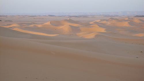
Dunes and sand integration: Orange-to-red dunes
lap against the rocky base, creating dramatic contrasts between
sandstone "rock forests" and shifting sands.
The overall
morphology results from a plateau carved by ancient water erosion and
then "softened" by wind, producing a highly broken, dissected landscape
especially in the north.
Geology and Formation
Tassili n'Ajjer
sits on the Tuareg Shield, part of the West African Craton's eastern
margin. Its geology records over 500 million years of Earth's history:
Precambrian base (c. 750–550 million years ago): Crystalline granite
and metamorphic rocks from the assembly of Gondwana.
Paleozoic
sedimentary cover (Cambrian to Devonian, c. 541–358 million years ago):
Thick layers of Ordovician and Devonian sandstone (with some clay and
limestone) deposited in marine and fluvial environments. During the Late
Ordovician Hirnantian glaciation (c. 445 million years ago), the region
was near the South Pole; glacial meltwater channels are preserved.
Silurian-Devonian transgressions turned it into a seabed and floodplain.
Long stability and uplift: The area was tectonically quiet for ~200
million years until Miocene uplift (c. 23–5 million years ago) arched
the shield, tilting layers and exposing them to erosion.
Pliocene-Quaternary volcanism added cones, craters, and lava flows in
the Adrar region.
Erosion history: Intense fluvial (water) erosion
during wetter periods (including the African Humid Period ~10,000 years
ago, when the Sahara was greener with lakes and rivers) carved gorges
and valleys. Subsequent hyper-arid conditions shifted dominance to
aeolian (wind) erosion, etching the iconic rock forests and
varnish-stained surfaces (desert varnish—metallic oxides giving rocks
black-to-red hues).
The sandstone is highly porous and
water-retentive, preserving traces of major climatic shifts from glacial
to desert conditions.
Climate and Hydrology
The climate is
hyper-arid desert (part of the West Saharan montane xeric woodlands
ecoregion), with scant and highly variable rainfall averaging ~25 mm (1
inch) per year (occasionally up to 150 mm locally). Diurnal temperature
swings are extreme: summer highs can exceed 50°C (122°F) at lower
elevations, while winters see lows near 0°C (32°F) and rare snow on
peaks. Annual mean temperature at ~1,100 m is around 20°C (68°F).
Despite the aridity, the elevation and sandstone create humid
microclimates in sheltered valleys and gullies. Hydrology features:
Gueltas (natural rock pools): Hundreds of permanent and temporary
pools fed by springs, including hot springs.
Wadis and oases:
Semi-permanent rivers like the Oued Iherir (with 45 pools, marshes, and
a waterfall) and Oued Imirhou (occasional surface flow for months).
These support relict vegetation and act as refugia from the surrounding
desert.
Ecological and Geographical Significance
The plateau's
isolation and varied microhabitats make it a center of plant diversity
in the Sahara. Relict flora includes Mediterranean, Sudano-Deccan, and
Saharo-Sindian species, such as the critically endangered endemic
Saharan cypress (Cupressus dupreziana, with ~100 of the world's ~153
known individuals in the "Valley of the Cypresses"), Saharan myrtle
(Myrtus nivellei), wild olive (Olea europaea laperrinei), and others
like oleander and date palms in wadi beds. Over 300 plant species are
recorded, many rare or endemic.
This geography—rising rocky plateau
amid endless sand—creates a unique "island" ecosystem that has preserved
evidence of past wetter climates while adapting to current
hyper-aridity. It exemplifies long-term desert geomorphic processes and
serves as a living record of Saharan environmental change.