Location: Bni Hamden, Constantine Province Map
Entrance Fee: DA20, children DA10
Open: 8am- 4pm
Tiddis is an ancient Roman settlement situated near Bni Hamden
village in the Constantine Province of Algeria. Tiddis also known as
Castellum Tidditanorum or Tiddi is an ancient Roman city constructed
in the 4th century BC. Its baths, gates, city walls, as well as
other beautiful religious, commercial and residence building present
tourists with a rear opportunity to view Roman planning unhindered
by later houses, or extensive looting by the locals. Thanks to its
isolate location Tiddis managed to avoid destruction by later
generations.
Some historians and archeologists call the
settlement "city of gods". Tiddis has numerous temples and churches
dedicated to various religious. This includes traditional Roman gods
like Vesta and Ceres, later cults of Mirtha and Carthaginian Baal
Hammon. many of the pagan temples were later converted to Christian
churches as a new religion spread through the region. It became a
dominant religion in the region dominated by large and prosperous
urban centers. Additionally Tiddis was a seat of a Christian bishop
as early as a 5th century.
The Tiddis Archaeological Site, also known historically as Castellum
Tidditanorum or simply Tiddis, is an ancient settlement perched on a
rugged mountain slope approximately 30 kilometers northwest of
Constantine (ancient Cirta) in northeastern Algeria. Situated at the
entrance to the dramatic Gorges du Khreneg, the site overlooks a barren
landscape of red earth and rocky outcrops, earning it the local nickname
"El Ksentina Kdima" or "Old Constantine" due to its strategic and visual
similarities to the nearby city. This fortified hilltop location
provided natural defenses, making it an ideal spot for habitation across
millennia. The ruins today span about 3000 years of history,
encompassing indigenous Berber (Numidian), Carthaginian, Roman, Vandal,
Byzantine, and early medieval occupations. Unlike many grand Roman
cities, Tiddis was a smaller castellum (fortified village) designed
primarily for military protection of Cirta's territory, yet it evolved
into a prosperous Romanized town with public monuments, residential
areas, and industrial zones. The site's archaeological significance lies
in its well-preserved adaptation of Roman urban planning to a
challenging topography, offering insights into colonial administration,
religious practices, and daily life in Roman North Africa.
Pre-Roman History
Human activity at Tiddis dates back to the
Neolithic period, with the oldest remains including pottery shards and
rock art inscriptions found on the hillfort along the east bank of the
Rhumel River (ancient Ampsaga). Indigenous Berber tribes, known as
Numidians, likely established the initial settlement due to its
defensible position, which could provide refuge from raids originating
from the southern deserts. By the time of Carthaginian influence in
North Africa (circa 4th-2nd centuries BC), Tiddis had come under Punic
cultural and possibly political sway. Evidence includes a shrine
dedicated to Baal, a prominent Carthaginian deity, as well as Punic
inscriptions and a defensive wall. The site's necropolis features
circular tombs called bazinas—typical Numidian burial structures with
central coffers—some of which predate Roman arrival and reflect local
Berber traditions blended with Punic elements. These tombs, located just
outside the later city gate, underscore Tiddis's role as a pre-Roman
hilltop refuge, populated before Rome's conquest of Numidia in 46 BC.
The Carthaginians, who founded coastal and select inland towns like
Cirta, likely influenced the area without direct settlement, as the
inhabitants adopted Punic script and deities while maintaining
indigenous customs.
Roman Period (1st Century BC to 4th Century
AD)
Following Rome's annexation of Numidia after the defeat of
Jugurtha and the establishment of the province of Africa Proconsularis,
Tiddis was transformed into a Roman castellum during the reign of
Emperor Augustus (27 BC–14 AD). Initially a military outpost and vicus
(small settlement), it formed part of the Confederatio Cirtense—a league
of four colonies including Cirta, Rusicade, Milev, and
Chullu—administered by Roman colonists from Cirta. The Romans rebuilt
and urbanized the site, adapting their grid-based planning to the
curved, sloping terrain: two main streets intersected at a central
forum, with a curia (assembly hall) and small square nearby. This layout
emphasized defense, with only one major entrance—a monumental northern
gate (partially reconstructed today) featuring door sockets and flanked
by ramparts along the cliff edges.
Tiddis flourished in the 3rd
century AD, becoming a prosperous respublica (self-governing community)
under Roman colonial administration. Key structures include public baths
and large cisterns constructed by M. Cocceius Anicius Faustus around the
mid-3rd century, essential for water management in this arid location.
Industrial facilities, such as tanneries, highlight economic activity,
while residential houses clung to the slopes, their foundations still
visible. Religious sites abound: a temple of Saturn on a crag (with
stelae now housed in the Constantine Museum), sanctuaries to Ceres and
Vesta, and a mithraeum (sanctuary to Mithras) likely dating to the 4th
century AD (earlier claims of 4th century BC appear erroneous, as
Mithraism emerged in the Roman era). Inscriptions reveal local
magistrates and decurions, indicating a Romanized elite.
A notable
figure from Tiddis is Quintus Lollius Urbicus, a native Berber-Roman who
rose to become prefect of Rome under Emperor Antoninus Pius (138–161 AD)
and governor of Britannia (139–142 AD), where he oversaw the
construction of the Antonine Wall. Several kilometers north of the site
stands his family's circular mausoleum, a memorial reflecting the
integration of local elites into the Roman imperial system. The town's
role as a protective fortress for Cirta's hinterland is evident in its
military origins, though it grew into a civilian hub with monumental
architecture.
Late Antiquity (5th to 7th Centuries AD)
In the
5th century, Tiddis fell under the Vandal Kingdom after their invasion
of North Africa in 429 AD, though it may have been more influenced than
directly controlled. By the end of the century, it became a Christian
bishopric under Byzantine rule following Emperor Justinian's reconquest
in 533 AD. The Byzantines strengthened defenses, likely against Berber
tribes, and two basilicas were built: one at the entrance and another in
a remote district. Historical records mention four bishops, including
Abundius, who attended the Council of Carthage in 484 AD under Vandal
King Huneric and was exiled. This period marks Tiddis's transition to a
Christian center, with the local Romance-speaking population adopting
the faith.
Decline and Abandonment (7th to 12th Centuries AD)
The Arab conquest in the late 7th century led to the disappearance of
the Romance community, though pottery evidence suggests a small village
persisted within the ruins, possibly with some Christian inhabitants,
until the 11th or 12th century. The primary cause of decline was chronic
water scarcity; despite cisterns and tanks, the site's isolation and
lack of reliable sources made sustained habitation difficult. Little is
known post-Arab invasions, but the town was gradually abandoned, leaving
ruins that blended into the landscape.
Archaeological
Significance and Modern Context
Tiddis was excavated primarily by
French archaeologists in the 20th century, revealing its layered history
and unique adaptation to terrain—unlike flat-grid Roman cities, streets
here wind along contours. Today, it stands as one of Algeria's most
impressively situated Roman sites, attracting visitors for its panoramic
views and historical depth. Though not a UNESCO site, it exemplifies
Roman-Berber syncretism in North Africa. Recent studies, including
neotectonic analyses, highlight environmental factors like earthquakes
that may have impacted structures. The site remains relatively
uncrowded, offering a glimpse into ancient resilience amid Algeria's
rugged wilderness.
Tiddis, also known as Castellum Tidditanorum, is an ancient Roman
archaeological site located in northeastern Algeria, approximately 19
miles (30 kilometers) northwest of Constantine in the Gorge of the
Khreneg. Perched on a steep mountain plateau overlooking the Rhumel
River valley, the site was originally a pre-Roman settlement with
Neolithic and Numidian roots, including circular tombs called bazinas
and a Punic wall dating back to the sixth century BCE. The Romans
developed it during the reign of Augustus as a vicus (small settlement)
and defensive castellum, part of a network protecting the larger city of
Cirta (modern Constantine). Much of the visible architecture dates to
the 3rd century AD, when the town flourished as a prosperous community
under Roman administration. Unlike typical Roman cities built on flat
terrain with orthogonal grids, Tiddis's layout was uniquely adapted to
the rugged, sloping landscape, resulting in terraced structures and an
irregular urban plan. The site's reddish rock formations and lack of
natural water sources shaped its engineering, emphasizing cisterns and
rainwater collection. By the late Roman period, it became a bishopric
with Christian elements, and later saw Vandal and Byzantine influences
before declining after the Arab conquest in the 7th century.
Archaeological evidence, including inscriptions and pottery, indicates
occupation persisted into the 11th century as a small village.
Urban Layout and Adaptation to Terrain
The urban design of Tiddis
deviates from the standard Roman cardo-decumanus grid due to its hilly
topography, creating a layout reminiscent of a medieval fortified town
with defensive priorities. The town spans a lower and upper section on
the plateau, connected by steps and pathways carved into the rock to
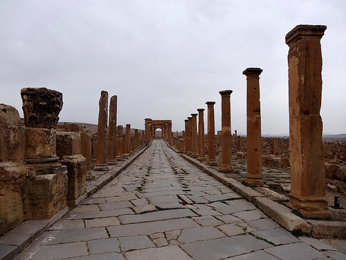
prevent landslides and accommodate the steep incline. The primary
thoroughfare, known as the Cardo Maximus, serves as the spine of the
settlement, running north-south from the main gate through the lower
town, featuring straight sections before bending sharply upward with
arches to reach the upper areas. This street, the widest in the town,
facilitated movement and commerce, intersecting with a series of
east-west steps rather than a traditional Decumanus Maximus. The central
intersection, marked by two prominent arches, housed the forum—a small
terraced square excavated into the hillside with three adjoining halls,
one likely serving as a tribunal for administrative functions. Houses
and public buildings were terraced along the slopes, with denser
residential areas on the cliff edges, incorporating the original
ramparts of the castellum for fortification. The site's isolation on the
plateau, without nearby springs, necessitated innovative water
management integrated into the urban fabric, while the overall plan
emphasized defensibility with only one major entrance.
Key
Architectural Features
Gates and Entrances
The primary access to
Tiddis is through the Northern Gate, a monumental portal that served as
the town's fortified entrance, with its upper section reconstructed in
modern times. This gate features a door socket and leads directly onto
the Cardo Maximus, flanked by remnants of walls and a Roman-era road.
Nearby, the Arch of Memmius (or Tiddis Arch) stands as a classic
triumphal structure, well-preserved with visible hinge points for
ancient gates, symbolizing Roman imperial presence. These elements
underscore the site's military origins as a castellum.
Streets
and Pathways
Beyond the Cardo Maximus, the streets consist of narrow,
winding paths and stairways adapted to the terrain, such as series of
stone steps connecting the lower town to the upper forum and hilltop
structures. These pathways, often terraced and reinforced against
erosion, integrated channels for rainwater drainage, directing flow to
cisterns. The absence of a formal Decumanus Maximus highlights the
site's organic growth from Numidian foundations, blending Roman order
with local morphogenesis.
Forum and Public Spaces
The forum,
located at the heart of the town near the Cardo-Decumanus intersection,
is a compact excavated terrace featuring a small square and curia
(assembly hall) referenced in inscriptions detailing local magistrates.
Flanked by arches, it included administrative buildings and possibly
market areas, with evidence of nundinae (market days) on the kalends and
ides. This central hub exemplifies Roman civic life adapted to limited
space.
Residential and Industrial Structures
Houses in the
lower town were spacious and terraced, often equipped with private
cisterns for domestic use, reflecting the site's water scarcity. Notable
is the Villa of the Mosaics, a prominent residence with an entrance
flanked by columns, intricate floor mosaics, and remnants of an olive
press, indicating agricultural processing. Industrial facilities
included tanneries and pottery kilns repurposed from bath furnaces,
showcasing economic activities integrated into the urban fabric.
Water Systems
Water management was a hallmark of Tiddis's
architecture, with no natural sources available. Numerous public and
private cisterns dotted the site, channeling rainwater through
integrated gutters and pipes. The largest cistern, completed in 251 AD
under M. Cocceius Anicius Faustus, supplied baths and neighborhoods,
featuring three massive basins and an inscription commemorating hillside
excavation. Smaller tanks of various shapes ensured survival during dry
seasons, a critical adaptation to the arid plateau.
Baths and
Thermal Structures
Tiddis boasted two bath complexes: a smaller one
at the hilltop and larger public baths in the lower town, possibly fed
by a distant spring or the great cistern. An inscription celebrates
their construction, highlighting hypocaust systems for heating and
furnaces later reused for pottery. These facilities underscore Roman
emphasis on hygiene and social gathering.
Religious and Funerary
Sites
Religious diversity is evident in Tiddis's architecture. Pagan
sanctuaries include the Mithraeum, a narrow hall along the Cardo Maximus
dedicated to Mithras (with 3rd-century AD reliefs of bull heads,
inscriptions, and symbols like a fascinus on a cock), temples to Ceres,
Vesta, and Saturn (the latter atop the crag, yielding stelae of a
bearded figure representing Romanized Baal). Christian elements emerged
by the 5th century, including a small basilica (possibly adapted from an
existing structure), a chapel with tombs (potentially a martyrium), and
two baptisteries—one with an immersion font under a canopy. Outside the
walls, Numidian bazina tombs and a circular mausoleum built by Quintus
Lollius Urbicus for the prominent Lollii family highlight funerary
practices.
Later Additions and Fortifications
By the 6th
century under Byzantine rule, fortifications were added atop the hill
using stones from dismantled Roman monuments, reinforcing the site's
defensive role. These walls incorporated earlier ramparts, adapting to
ongoing threats.
Archaeological Significance
Tiddis stands out
for its symbiosis of Numidian and Roman elements, illustrating how Roman
engineers adapted standard urban principles to challenging terrain while
incorporating local techniques like rock-cut dwellings and
fortifications. The site's well-preserved ruins, including inscriptions
to emperors like Septimius Severus and Julia Domna, provide insights
into Roman provincial life, religious syncretism, and economic
activities in Numidia. Its decline due to water issues highlights
environmental vulnerabilities in ancient settlements. Today, Tiddis
offers a vivid glimpse into a lesser-known Roman outpost, with ongoing
excavations revealing its layered history from pre-Roman to medieval
times.