Location: Map
Area: 11,700km²
Chobe National Park is a nature reserve situated in the Northern part of Botswana. It covers an area of 11,700km². Originally the region of Chobe National Park was inhabited by Basarwa people or San bushmen. These were hunter gatherers who left interesting rock paintings in different parts of the park. Much of the Chobe National Park is covered by savannah. During rainy season it blossoms with flowers, wetlands appear as rivers and lakes swell. During the dry season, however, the savannah turns less inviting. The grass turns yellow, desert overtakes large portion of the park and many animals gather close to water sources.
Ancient and Indigenous History
The region’s earliest known
inhabitants were the San (Basarwa or Bushmen), nomadic hunter-gatherers
who roamed the area for thousands of years in search of water, wild
fruits, and game. Archaeological evidence includes San rock paintings in
the rocky hills of the park (such as those at Gubatsa Hills), with some
artworks dating back potentially 600–4,000+ years. These paintings
depict animals, hunting scenes, and spiritual motifs, underscoring the
deep cultural connection between the San and the landscape.
Over
time, other groups migrated into or settled the area. By the 18th–19th
centuries, the Hambukushu, Bayei (Yeyi), and Basubiya (Basubia) peoples
had joined or interacted with the San. The Bayei, for instance, moved
from the upper Chobe River region into nearby areas like the Okavango
Delta. Earlier regional dynamics included brief influences from groups
like the Kololo (who settled along the Chobe River around 1835 before
being displaced) and interactions with Ndebele and other migrating
communities during the turbulent 19th-century mfecane period in southern
Africa. These peoples practiced a mix of hunting, gathering, fishing,
and some agriculture or pastoralism, living in harmony with the seasonal
floods of the Chobe-Linyanti river system, which has cycled between wet
and dry phases for centuries.
European Exploration and Early
Colonial Period (Mid-19th to Early 20th Century)
European contact
began in the 1850s when Scottish explorer David Livingstone passed
through the area en route to Victoria Falls (just over an hour’s drive
away today). He noted the Chobe River’s depth and potential as a
navigable waterway. Around the same time, big-game hunters arrived
seeking ivory from elephants and trophies from other wildlife,
contributing to early pressure on game populations.
By the late 19th
century, the region became part of the Bechuanaland Protectorate under
British administration (formalized in 1885 and extended northward to the
Chobe River in 1890). Much of the future park area was classified as
crown land, with minimal development due to the harsh Kalahari
environment, tsetse fly risks, and sparse population. Indigenous
land-use patterns continued largely uninterrupted, but colonial
land-tenure systems began dividing territories, setting the stage for
later conservation.
Path to Protection: Colonial Proposals and
Delays (1930s–1950s)
The idea of protecting the area for wildlife and
tourism emerged in the 1930s. In 1931, colonial authorities (including
proposals linked to figures like Sir Charles Rey) advocated for a
national park or reserve to safeguard diverse wildlife and promote
sustainable tourism. The following year (1932), about 24,000 km² around
the Chobe district was declared a non-hunting area; this was expanded in
1934 to roughly 31,600 km².
Progress stalled in 1943 due to a severe
tsetse fly infestation, which devastated livestock and wildlife and made
large-scale protection impractical. Plans were largely abandoned for a
decade. By 1953 (or around 1957 in some accounts), the project revived
with a scaled-down proposal for about 21,000 km² as a game reserve.
Industrial activities, particularly timber extraction, had begun in
pockets like Serondela, adding complexity.
Establishment as Game
Reserve and National Park (1960s)
Chobe Game Reserve was officially
proclaimed in 1960 (some sources cite 1961), though smaller than
originally envisioned. Botswana gained independence from Britain in
1966, and shortly afterward the reserve was upgraded. It was declared
Botswana’s first national park in 1967/1968 (most authoritative sources
pinpoint 1968 for the formal national park status), making it the
country’s inaugural protected area of this kind. The park’s creation
aligned with the new nation’s vision of conservation-led tourism and
wildlife protection.
At proclamation, several industrial settlements
(especially timber operations at Serondela) remained within boundaries.
These were gradually relocated, with the entire protected area cleared
of human activity by 1975. Minor boundary expansions and adjustments
occurred in 1980 and 1987 to refine the park’s size and shape.
Post-Establishment Developments and Modern Era (1970s–Present)
Tourism infrastructure developed rapidly. The iconic Chobe Game Lodge
(opened around 1972–1973) became Botswana’s first five-star luxury
safari lodge, pioneering high-end ecotourism. In 1975, it gained
international fame when actors Elizabeth Taylor and Richard Burton
married there for the second time (at the nearby Kasane Magistrate’s
Court, with lodge ties).
Conservation was strengthened under the
Wildlife Conservation and National Parks Act of 1992, which governs the
park today alongside the Department of Wildlife and National Parks.
Anti-poaching efforts have been highly effective, contributing to stable
or growing populations of elephants (estimated at 50,000+ in the broader
region, with Chobe supporting one of Africa’s largest concentrations),
buffalo, lions (notably those that prey on elephants), and hundreds of
bird species.
The park’s ecosystems remain dynamic due to the Chobe
River’s flooding cycles—historically shifting between wet and dry phases
over centuries (e.g., the Savuti Channel flowed 1967–1981, dried until
2008, and continues to influence wildlife migrations). Borders with
Namibia, proximity to Zimbabwe and Zambia, and links to other Botswana
parks (like Moremi) enhance its role in transfrontier conservation.
Today, Chobe National Park stands as a testament to Botswana’s
commitment to wildlife protection, balancing indigenous heritage,
colonial legacies, and modern sustainable tourism. Traces of its layered
past—San rock art, old timber sites at Serondela, and the river’s
ancient floodplains—remain visible amid one of the world’s most
exceptional game densities.
Topography and Geology
The park sits within the vast Kalahari
Basin, a sand-filled depression characteristic of much of southern
Africa. The terrain is predominantly flat to gently undulating, with
an average elevation of about 964 meters (roughly 3,160 feet) above
sea level. Elevations range from a minimum of around 918 m near the
riverine lowlands to a maximum of 1,094 m in the slightly higher
interior areas, giving a modest relief of only about 176 meters
across the entire park. This low-relief landscape is dominated by
deep Kalahari sands (sandveld) in most areas, transitioning to
patches of harder, rockier soils (hardveld) with scattered outcrops
in the east.
Notable landforms include:
Magwikhwe Sand
Ridge: A prominent, ancient shoreline feature (remnant of a large
paleo-lake) stretching roughly 100 km long and rising about 20 m
above the surrounding plains. It runs through the western and
central sections and marks an old shoreline from prehistoric times.
Gubatsa Hills: Small volcanic outcrops in the Savuti area, featuring
rocky hills with ancient San (Bushmen) rock art.
Seasonal pans:
Natural clay-lined depressions scattered across the park (especially
in the Ngwezumba and Nogatsaa areas) that fill with rainwater during
the wet season, creating temporary wetlands on otherwise arid
terrain.
Savuti Marsh: A relic of a much larger ancient inland
lake, now a dynamic grassland/marsh system shaped by past tectonic
activity.
The underlying geology is influenced by extensions
of the East African Rift Valley fault lines, which have dramatically
affected ancient drainage patterns and continue to influence modern
hydrology through subtle tectonic shifts.
Hydrology: Rivers,
Marshes, and Floodplains
Water is the defining geographical
element of Chobe National Park, creating stark contrasts between
permanently wet riverine zones and arid interiors. The park’s
hydrology is shaped by the Chobe–Linyanti–Kwando river system, which
originates in the highlands of Angola and flows through the region.
Chobe River (northern boundary): The park’s primary perennial
water source. It forms broad floodplains along the northeastern edge
(Serondela/Chobe Riverfront area), which inundate seasonally and
support lush riparian vegetation. The river is widest and most
scenic near Kasane, with deep channels and shallow lagoons.
Linyanti River and Kwando River (northwestern boundary): These form
the Linyanti Marsh/Swamps complex in the northwest corner. The area
features extensive floodplains, lagoons, and papyrus-lined channels,
creating a wetland mosaic that borders Namibia’s Nkasa Rupara
National Park.
Savuti Channel: One of the park’s most
geologically fascinating features—an ancient, intermittent riverbed
linking the Linyanti system to the Savuti Marsh. Due to tectonic
movements along rift-related fault lines, the channel dries up for
decades and then suddenly reactivates (e.g., it last flowed
significantly in 2010 after being dry since 1982). This creates
dramatic landscape changes: dead trees line former banks, and the
marsh transforms from dusty grassland to flooded wetland.
Ngwezumba Pans and other seasonal features: In the drier central and
eastern hinterland, clay pans (some semi-permanent) collect
rainwater, while black-cotton soils in marshy zones become
impassably sticky when wet and hard as concrete when dry.
The
park experiences strong seasonal hydrological cycles driven by a
subtropical semi-arid climate: a hot, dry season (May–October)
concentrates water in the permanent rivers and a few pans, while the
wet season (November–April, peaking January–February) brings
thunderstorms, flooding floodplains, and filling interior pans.
Main Geographical Regions and Ecosystems
Chobe is not a
uniform landscape but a mosaic of four distinct ecosystems, each
defined by unique combinations of soil, water availability, and
topography:
Chobe Riverfront (Serondela area, northeast):
Lush floodplains and dense riverine woodlands (historically
featuring hardwoods like Afzelia quanzensis and Baikiaea plurijuga,
now heavily shaped by elephant activity). This is the most
accessible and water-rich zone, with broad grassy plains that green
dramatically after rains.
Savuti (western stretch): Open
savannas, rolling grasslands, and the iconic Savuti Marsh. The area
includes the hot, dry hinterland with the Magwikhwe Sand Ridge and
features the erratic Savuti Channel. Vegetation shifts from
grasslands to scattered woodlands.
Linyanti Marshes (northwest):
Remote wetlands with riverine woodlands, open floodplains, and
lagoons along the Linyanti/Kwando system. This zone feels more
“swampy” and forested than the riverfront.
Nogatsaa/Ngwezumba
hinterland (central/eastern interior): The least-visited, arid core
with mopane and miombo woodlands, acacia thickets, seasonal pans on
clay soils, and patches of black-cotton soils. This is classic
Kalahari sandveld with thorn bush and deeper sand dunes/ridges.
Vegetation overall transitions from riverine forests and flood
grasslands near water to mopane-dominated woodlands, acacia
savannas, broadleaf miombo, and thorny shrublands on deeper sands
farther inland. Baobab trees and cathedral-like mopane stands are
characteristic in drier zones.
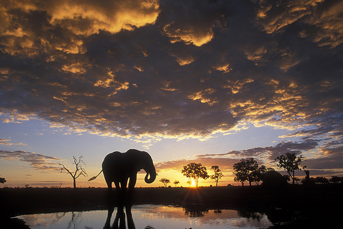
Chobe National Park has a significant elephant population, which has
been steadily increasing during the 20th century and is currently
estimated at about 120,000. The Chobe elephant is migratory, migrating
up to 200 km from the Chobe and Linyanti rivers, where they concentrate
in the dry season, to the depressions in the southeast of the park,
where they disperse in the rainy season.
In addition to
elephants, much other wildlife can be seen, especially in the dry winter
months. It is on these dates when large concentrations of elephant,
buffalo, zebra, giraffe, impala and other animals gather along the river
to drink. Chobe National Park is a major destination for wildlife
viewing of all kinds, and a must-see safari option for the traveler,
especially river safaris.
The condition of the trails in the park is highly dependent on the
season and the rain and it is best to have an all-terrain vehicle to get
around. Sand can become a problem on the banks of the Chobe River during
the dry season, especially when it is hot. Conversely, during the rainy
season, the tracks become muddy.
Savuti
Savuti tracks are
very sandy and require some driving experience. After rain, driving near
swamps presents the risk of getting stuck.
Nogatsaa
The tracks
of Nogatsaa are wet during the rainy season and few of them are passable
in this season. During the dry season, the tracks to go from one valley
to another are very small and sandy. Once you have left the paved road
coming from Kasane, you will have to do 20 km on very sandy tracks
before arriving on tracks in better condition.
Chobe Park is renowned for being the place with the highest concentration of elephants in Africa (around 120,000 individuals live in the park). This population has been growing continuously since 1990, a time when there were a few thousand specimens in the park. Despite the large concentration of elephants, the Chobe administration has so far refused to adopt the artificial population reduction measures employed by other parks.
The park includes numerous accommodation facilities for tourists, including several camping areas and many lodges. Malaria is present in the area where the park is located.
The traveler heading to Chobe can buy a detailed map of the place at
gas stations. On the same map, The Shell map of the Chobe National Park,
there is a list of the animals that can be seen in the park.
African Loxodonta - African elephant
Hippopotamus amphibius - common
hippopotamus
Camelopardalis giraffe - giraffe
Phacochoerus
africanus - phacozero
Phacochoerus aethiopicus - Eastern phacoceros
Syncerus caffer - caffer buffalo
Taurotragus oryx - common eland
Tragelaphus strepsiceros - great kudu
Tragelaphus species — not sewn
Tragelaphus scriptus - hieroglyphic antelope or bushbok
Connochaetes
taurinus - blue grass or listed
Damaliscus lunatus - topi
Hippotragus niger - sable antelope
Hippotragus equinus - Rwandan or
equine antelope
Kobus ellipsiprymnus - aquatic antelope
Kobus milk
- antelope milk
Kobus vardonii - white
Redunca arundinum - common
or southern redunca
Aepyceros melampus - impala
Sylvicapra grimmia
- common or gray duiker
Raphicerus campestris - common raphice or
steenbok
Ceratotherium simum - white rhinoceros
We say bicornis -
black rhinoceros
Equus burchelli - Burchell's zebra
Crocuta
crocuta - spotted hyena
Brunnea hyena - brown hyena
Proteles
cristatus - earthwolf or proteles
Lycaon pictus - African lycaon or
wild dog
Canis mesomeles - common or black-backed jackal
Canis
adustus - striped jackal
Otocyon megalotis - fox eyed or ototion
Civettictis civetta - African civet
Genetta genetta - common horse
Mungos mungo - mungo or mangosteen listed
Sanguinella gallerella -
rufa mangosteen
Helogale parvula - mother mangoes
Leo panther -
lion
Brown Panthera - leopard
Acinonyx jubatus - cheetah
Caracal caracal - caracal (also Felis caracal)
Leptailurus serval -
serval (also Felis serval)
Felis silvestris lybica - African mountain
cat
Aonyx capensis - Cape inert otter
Mellivora capensis - ratel
or male badger
Ictonyx striatus - Libyan or North African fox
Orycteropus afer - ant hog
Manis temminckii - Temmick or terrestrial
pangolin
Papio ursinus - Chacma papion or black papion
Cercopithecus aethiops - green or whole cercopithecus (also Chlorocebus
aethiops)
Galago senegalensis - Lesser gazelle
Lepus saxatilis -
scrub hare
Paraxerus cepapi - African arboreal squirrel ?
Pedetes
capensis - Cape hare or jumping hare
Hystrix africaeaustralis - Cape
porcupine