Location: Kgalagadi District Map
Area: 38,000 km2 (15,000 sq mi)
Species: lions, cheetah, hyena, raptors, leopard, wildebeest, eagles, secretary bird, vultures and etc.
Kgalagadi Transfrontier National Park is located in Kgalagadi District of Botswana. Kgalagadi Transfrontier National Park covers an area of 38,000 km2 (15,000 sq mi) of African savannah as well as arid and semi arid desert. The symbol of the park is a gemsbok, an antelope with long twisted horns. Other animals include giraffes, Kalahari lions, suricates that live in family communities, ostriches and many others.
The park is located in the Kalahari Desert, located in the extreme southwest of Botswana, with 25% of its area located in South Africa, close to the Northern Cape Province and the border with Namibia.
Indigenous and Pre-Colonial History
The Kalahari region, including
what is now KTP, has been inhabited for thousands of years by
hunter-gatherer societies. The earliest and most prominent groups were
the San (Bushmen), particularly the ‡Khomani San, along with other
Khoe-speaking peoples. These groups lived in small, mobile bands,
relying on sustainable hunting, gathering, and deep knowledge of the
desert environment (including tsama melons for water in dry periods).
They viewed land as communal, with cooperative rules for resource
sharing.
The Kgalagadi (a Tswana-related group) were among the first
to penetrate the northern Kalahari and coexisted relatively peacefully
with Khoe-speaking inhabitants. The name “Kalahari” itself stems from
Kgalagadi terms linked to the Makgadikgadi salt pans or the “great
thirstland.”
Later, around 150 years ago (mid-1800s), the Mier
community (of mixed descent, often classified as “Coloured” under
apartheid) migrated northward from the Cape Colony, fleeing British
rule. They settled in the Northern Cape and parts of the Kalahari,
becoming primarily pastoralists (cattle, sheep, goats) and displacing
some San groups.
European contact was limited until the late 19th
century, though the area saw trade and exploration. One early settler
family was the Le Riches (of German/Dutch descent), who entered from
Namibia around 1884–1899.
Colonial Annexation and Early
20th-Century Settlement (1891–1930)
In 1891, the park area (and the
adjacent Mier region) was annexed to British Bechuanaland.
German
colonial activities in South West Africa (Namibia) influenced the
region; during the 1904–1908 Nama-Herero conflicts, German troops
briefly used a station at Groot Kolk (in what is now the park) for
communications.
During World War I (1914), the Union of South Africa
drilled boreholes along the Auob River as a potential invasion corridor
into German South West Africa. Local guards (often from Mier or San
communities) were settled there with livestock, but the corridor was
never used. After the war, these families remained, contributing to
overgrazing and environmental strain.
Scottish surveyor Rodger
“Malkop” Duke Jackson (hired around 1914–post-WWI) surveyed and beaconed
the area into large farms (10,200–12,800 ha each), giving many boreholes
Scottish names still used today (e.g., references to “Thirteenth” or
“Fourteenth” boreholes). Some farms were allocated to settlers,
including borehole caretakers, but the harsh environment (droughts,
reliance on tsama melons) made farming difficult. Many turned to
hunting, accelerating game depletion alongside commercial biltong
hunters.
By the 1920s, overhunting had drastically reduced wildlife
populations, particularly migratory herds of gemsbok (oryx), springbok,
and others.
Establishment of the Kalahari Gemsbok National Park
(1931)
South Africa’s second national park (after Kruger) was
proclaimed on 31 July 1931 as the Kalahari Gemsbok National Park.
Minister of Lands Piet Grobler (who had helped establish Kruger in 1926)
was reportedly taken on a deliberate “hunting trip” by local influencers
to witness the game’s near-disappearance. Shocked, he pushed for
protection of the area between the Auob and Nossob rivers (and to the
SWA border) to safeguard migrating game from poaching.
The government
repurchased most allocated farms (a few remained private initially). The
park initially covered about 9,600 km² after later additions southwest
of the Auob.
The Le Riche family became synonymous with the park:
Johannes le Riche (son of early settler Stoffel) was the first warden in
1931, a position held by family members (father to son, brother to
brother) until 1995. They played a key role in early management and
anti-poaching.
This proclamation displaced indigenous communities:
San were forced into farm labor (often paid in kind or alcohol), eroding
their hunter-gatherer lifestyle; Mier people were resettled south of the
park under the 1930 Coloured Persons Settlement Areas Act.
Botswana Side and Informal Cross-Border Cooperation (1932–1948)
In
1932, Bechuanaland (Botswana) proclaimed the adjacent Gemsbok Game
Reserve (upgraded to national park status in 1971). It was formally
proclaimed in 1938 as a larger area east of the Nossob River.
Mabuasehube Game Reserve was added in 1971 and incorporated in 1992.
In 1948, an informal verbal agreement between the Bechuanaland
Protectorate and the Union of South Africa created a de facto
transfrontier conservation area. No fence was built along the
international border (the Nossob Riverbed), allowing free animal
movement. The two parks were managed informally as a single ecological
unit thereafter.
Path to Formal Transfrontier Status (1989–2000)
Proposals for formal joint management emerged in 1989, but full
integration waited until after South Africa’s 1994 democratic
transition.
In June 1992, a joint management committee was formed by
South African National Parks (SANParks) and Botswana’s Department of
Wildlife and National Parks. A shared management plan was approved in
1997, with agreements on tourism and equal sharing of entrance fees.
On 7 April 1999, Botswana and South Africa signed a historic bilateral
treaty formalizing management as a single ecological unit.
On 12 May
2000, Presidents Festus Mogae (Botswana) and Thabo Mbeki (South Africa)
officially launched the Kgalagadi Transfrontier Park—Africa’s first
“peace park.” It symbolized post-apartheid cooperation and transnational
conservation.
Land Restitution and Indigenous Rights
(1995–Present)
The park’s establishment involved significant
dispossession of the ‡Khomani San and Mier communities. A major land
claim was launched in 1995–1996 following South Africa’s democratic
elections.
In March 1999, a settlement returned land to the
communities. In May 2002, approximately 25,000–27,769 ha inside the park
(San Heritage Land) and 30,000–42,000 ha outside (Mier and additional
San farmland) were restituted, forming the !Ae!Hai Kalahari Heritage
Park (a contractual park co-managed with SANParks via a Joint Management
Board).
This includes rights for sustainable resource use, cultural
practices (e.g., traditional bow hunting in designated zones), and
ecotourism. The !Xaus Lodge (opened 2007, meaning “heart” in the local
language) was developed as a community-owned facility, generating jobs
and preserving San cultural villages and crafts.
Challenges persist,
including intra-community tensions, sustainable resource management, and
balancing conservation with livelihoods, but the settlement represents a
landmark in community-based conservation.
The region has an arid climate. During summer days it can be extremely hot, especially in January. And during winter nights, temperatures can drop below freezing. The extreme temperatures already recorded were -11 °C and 45 °C. It has average annual precipitation between 127 mm in the east and 350 mm in the west, with the months between January and April being the rainiest.
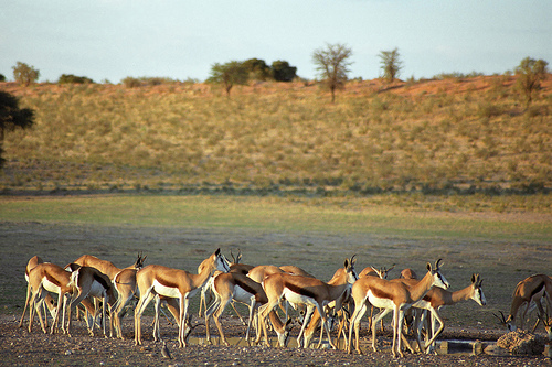
The park is home to more than 170 species of birds and a variety of antelope species, including springbok, oryx, kaama and eland. Also found are the black-maned lion, jackal, brown hyena, wildcats, cheetah, leopard, lynx, bat-eared fox, silver fox, Cape fox, bearded wolf and black-footed cat. . Of the endangered species, the park is home to the African wild dog, pangolin, honey badger and Woosnam desert rat.
The biome is shrub savanna and small areas of grass savanna, featuring deep-rooted acacias and other hardy plants. Cucumis metuliferus and the succulent Hoodia gordonii are plants endemic to the region.
Kgalagadi Transfrontier Park (KTP) is a vast transboundary protected
area in the southern Kalahari Desert, straddling the border between
South Africa (Northern Cape Province) and Botswana (Kgalagadi District).
Its name derives from the Setswana word meaning “place of great thirst,”
reflecting its arid character. The park was formally established in May
2000 by uniting South Africa’s Kalahari Gemsbok National Park
(proclaimed in 1931) and Botswana’s Gemsbok National Park, creating one
of Africa’s largest and oldest transfrontier conservation areas. It
allows unrestricted wildlife movement across an unfenced international
border.
Location and Size
The park lies at approximately
25°46′S 20°23′E, with Upington (South Africa) as the nearest major city.
It occupies the southwestern corner of Botswana and northwestern South
Africa, bordering Namibia to the west. Roughly three-quarters of its
area is in Botswana and one-quarter in South Africa. The total area is
approximately 38,000 km² (about 14,700 sq mi or 3.8 million hectares),
making it one of the world’s largest conservation areas—comparable in
scale to Switzerland or larger than several small European countries.
Topography and Landforms
The landscape is dominated by the iconic
red sand dunes of the Kalahari, which are longitudinal (parallel) dunes
oriented northeast-southwest. These dunes are typically 6–15 meters (or
higher in places) tall, stabilized by sparse vegetation, and separated
by interdune valleys or “streets.” The reddish-orange color comes from
iron oxide coatings on the quartz sand grains. Interspersed are open
grassy plains (sandveld), low shrublands, and fossil river valleys. The
terrain is relatively flat overall, with an average elevation of around
900–1,000 meters above sea level (highest points near 1,056 m).
In
the northeastern section (particularly the Mabuasehube area, formerly a
separate reserve now integrated into KTP), the landscape shifts to
include a series of large salt and clay pans (depressions that fill with
water after rains). These pans—such as Bosobogolo, Mpayathutlwa,
Mabuasehube, Leshologago, Khiding, and Monamodi—serve as focal points
for wildlife and provide mineral licks. The park can be broadly divided
into two ecological zones: the southwestern duneveld (more arid,
semi-desert with prominent dunes) and the northeastern plains thornveld
(slightly more vegetated savanna).
Hydrology: Ephemeral Rivers
and Water Sources
Two major ephemeral rivers—the Auob and
Nossob—define much of the park’s hydrology. These are fossil riverbeds
that rarely (if ever) flow at the surface—perhaps only once per century
or briefly after exceptional thunderstorms. The Nossob River roughly
marks parts of the South Africa–Botswana border. Underground water
percolates through the sandy substrate, sustaining vegetation in the
riverbeds even during prolonged droughts. There are no permanent natural
surface water sources; artificial waterholes supplement wildlife needs.
The sandy soils drain rapidly, preventing long-term surface water
retention. Ancient gravel terraces and clay pans are remnants of wetter
climatic periods in the distant past.
Climate
KTP has a
classic arid to semi-arid desert climate (Köppen BWh/BSh). Annual
rainfall averages about 200 mm in the southwestern areas (increasing
slightly eastward to 120–350 mm across the park), falling mainly as
short, isolated convective storms during the summer rainy season
(December–April). Precipitation is highly variable and unreliable.
Temperatures are extreme:
Summer (October–April): Daytime highs
frequently exceed 40 °C (up to a recorded 45.4 °C), with hot, dry
conditions from October–December transitioning to thundery rains.
Winter (May–September): Nights can drop below freezing (record low –10.3
°C), though days remain mild (around 20–28 °C).
Geology
The
park sits within the larger Kalahari Basin. The underlying bedrock
consists of ancient Precambrian igneous and metamorphic rocks of the
Kaapvaal and Zimbabwe Cratons—some of Earth’s oldest continental crust
(>2.5 billion years old). These are overlain by sedimentary layers from
the Late Paleozoic to Mesozoic Karoo Supergroup (sandstones and shales).
The modern surface is shaped by Kalahari Sands, wind-deposited (aeolian)
quartz sands laid down over the past two million years during drier
climatic phases. These sands form the dune systems and are nutrient-poor
but allow deep root penetration. Fossil evidence in the riverbeds and
pans indicates past lakes and wetlands from wetter periods.
Soils
and Vegetation
Soils are predominantly deep, red-to-orange Kalahari
sands—well-drained, low in nutrients, and highly erodible by wind.
Vegetation is sparse and adapted to aridity: drought-resistant grasses
(e.g., Stipagrostis species), shrubs (driedoring, raisinbush),
succulents (gemsbok cucumber), and scattered trees. Camel thorn acacias
dominate riverbeds, providing shade and forage, while shepherd’s tree
and other hardy species appear in interdune areas. After rains, brief
greening occurs with flowering grasses and herbs. In the Mabuasehube
pans, tree/shrub savanna mixes with open grasslands. Overall biomass is
low, but the open terrain creates excellent visibility for wildlife
viewing.
There are two communities that live on the outskirts of the park, the
Khomani San and the Mier. The Government of South Africa, together with
South African National Parks and the two communities, signed the !Ae!Hai
Kalahari Heritage Park Agreement, stating that 25 000 hectares of land
within the park boundaries belong to the Khomani San and 25 000 hectares
of land within the park's boundaries belong to the Mier. The communities
also had their land ownership, outside the park's boundaries,
recognized. This agreement enables communities to improve their
livelihoods.
According to the park's management plan, communities
can use natural resources for cultural, historical and ceremonial
purposes in accordance with indigenous traditions, including traditional
hunting with bow and arrows. The South African government has also built
a community lodge, !Xaus Lodge, where a private operator manages the
lodge and splits the concession fee between the two communities and the
park administration.
The treaty signed between the two countries allows visitors to travel between the two countries, within the park's limits, without problems with immigration and customs. The main entry and departure points are the Twee Rivieren Gate in South Africa; Mata-mata, in Namibia; Two Rivers and Nossob, in Botswana, which have camping facilities, chalets, shops and restaurants. The park can be visited on your own or through tours offered by operators. It is necessary to make a reservation in advance, as authorities limit the number of vehicles traveling on the roads, and the number of campers staying in the campsites and days of stay. Independent visitors must travel in a convoy with at least two vehicles, and the recommended vehicles are 4x4s, due to the bumpy and sandy road conditions.