Location: border between Botswana and Namibia
Area:n275 000 acres (111 288 hectares)
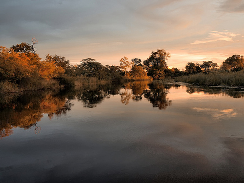
The Linyanti Swamp, also known as the Linyanti Wetlands or Marshes, is a vast, pristine wilderness area in northern Botswana, forming part of the larger Kwando-Linyanti-Chobe ecosystem. Situated between the Okavango Delta to the west and Chobe National Park to the east, it lies along the Linyanti River, which marks the border with Namibia's Caprivi Strip. This remote region spans approximately 1,250 square kilometers within the Linyanti Wildlife Reserve and is characterized by seasonal floodplains, lagoons, and marshes that support one of Africa's most diverse and concentrated wildlife populations. As a private concession area, it offers exclusive, low-impact safaris with minimal human presence, emphasizing conservation and immersion in an untamed landscape.
Linyanti Swamp (also known as Linyanti Marsh or Linyanti Wetlands) is
a pristine wetland system in northern Botswana’s Chobe District, formed
where the Kwando River (originating in Angola) enters Botswana, becomes
the Linyanti River, and spreads across Kalahari sands into a network of
channels, lagoons, papyrus reedbeds, floodplains, and riverine
woodlands. It lies along the Botswana-Namibia border (with Namibia’s
Caprivi/Zambezi Strip to the north), west of Chobe National Park, and
connects eastward to the Selinda Spillway (Magwegqana) and the Okavango
Delta system. Often described as a “mini-delta,” it covers an area of
seasonal and permanent wetlands that support exceptional wildlife
concentrations, including large elephant herds, predators (lions,
leopards, wild dogs), rare antelope (sitatunga, red lechwe, roan,
sable), hippos, crocodiles, and hundreds of bird species.
Its history
spans deep geological time, prehistoric human occupation, 19th-century
political upheaval and European exploration, and modern
conservation-focused tourism. The swamp’s story is inseparable from
tectonic instability, river capture, and the broader
Okavango-Chobe-Zambezi drainage evolution.
Geological Origins and
Prehistoric Landscape Evolution (Millions to Thousands of Years Ago)
The Linyanti Swamp’s formation is driven by the same tectonic processes
that shaped much of northern Botswana’s wetlands. Roughly 2 million
years ago, extensions of the East African Rift Valley created fault
lines across the Kalahari Basin. These parallel faults (including the
Linyanti fault and Gumare fault) caused uplift and subsidence,
“capturing” ancient rivers and preventing them from reaching the sea.
The Kwando/Linyanti River, along with the Upper Zambezi, Chobe, and
Okavango systems, once formed a single vast river that flowed southeast
through what is now the Mababe Depression to join the Limpopo River and
empty into the Indian Ocean.
Tectonic shifts raised the Linyanti
fault, diverting the Kwando along the fault line and forcing it to
spread across the flat Kalahari sands (gradients as low as 1:4000).
Silting and sediment buildup gradually created a small inland delta—the
Linyanti Marshes—analogous to how the Thamalakane fault trapped the
Okavango.
In the Quaternary period (last ~2.6 million years), the
region experienced repeated wet-dry cycles linked to paleo-lakes. The
nearby Mababe Depression was once part of vast Lake Makgadikgadi (one of
Africa’s largest ancient lakes). Palustrine (marshy) environments in the
Chobe-Linyanti basin deposited carbonate islands and sand ridges between
~55,000 and 10,000 years ago. Tectonic movements, epeirogenic uplift,
fluvial reworking, and aeolian (wind-blown) sands shaped the current
mosaic of floodplains, paleochannels, and woodlands.
The Savuti
Channel (which feeds the nearby Savuti Marsh in Chobe National Park)
exemplifies this dynamism: it is a relic of a large inland lake whose
supply was cut by tectonics. The channel has cycled between flowing and
dry for centuries—last flowing 1967–1981, drying until 2008, and showing
variable patterns since—directly affecting the Linyanti system’s water
levels. The Selinda Spillway further links the Linyanti to the Okavango,
occasionally allowing bidirectional flow and creating a shared wetland
corridor.
These processes have produced a highly dynamic ecosystem
where slight earth tilts can reroute entire rivers, making the Linyanti
one of the most geologically active wetland systems in southern Africa.
Early Human Occupation and Indigenous Peoples (Tens of Thousands of
Years Ago to 18th Century)
Northern Botswana’s wetlands, including
the Linyanti area, have supported human life for over 200,000 years.
Genetic studies identify the broader Makgadikgadi-Okavango wetland
region (immediately south and west of Linyanti) as the likely ancestral
homeland of all modern humans (Homo sapiens), where a stable population
of Khoisan (San/Bushmen) hunter-gatherers thrived in lush wetlands
around 200,000–130,000 years ago before dispersing across Africa and the
world.
San peoples left rock art and lived as hunter-gatherers
around permanent water sources, including early Linyanti floodplains.
By ~2,300 years ago, agriculture and iron-working arrived with
Bantu-speaking groups. In the 18th century, the Yeyi (Mayeyi) people
migrated into the area, establishing fishing and farming communities
along the rivers.
The Linyanti remained a remote, low-density
zone of seasonal resource use until the 19th century.
19th
Century: Makololo Conquest, Capital of a Kingdom, and European
Exploration
The most dramatic chapter in Linyanti’s documented human
history occurred in the 1830s–1850s during the Difaqane (scattering)
wars. The Makololo (or Kololo), a Sotho-speaking group led by Chief
Sebetwane, migrated northward from South Africa, conquering local
peoples and establishing a short-lived but powerful kingdom. They made
their capital at Linyanti (specifically the settlement of Sangwali on
the Linyanti River), using the swamp’s resources for defense, fishing,
and trade.
In 1851, Scottish missionary-explorer David Livingstone
arrived at Linyanti. He met Sebetwane, who died shortly afterward
(possibly from pneumonia or complications of old wounds). Livingstone
conducted the first European scientific observations of the area,
treated the new chief Sekeletu, and used Linyanti as a base for his epic
trans-African expeditions (1852–1856 and later). From here, he explored
the Zambezi River, discovered Victoria Falls (which he named), and
mapped routes to the Atlantic and Indian Oceans. His writings brought
the region to global attention, describing the swamps’ wildlife, rivers,
and fever-ridden marshes.
The Makololo kingdom collapsed in the 1860s
due to internal strife, disease, and revolts by subject groups
(including the Lozi). The area reverted to local Yeyi and other Bantu
communities, with the Linyanti River serving as a trading corridor.
Colonial Era to Independence (Late 19th–Mid-20th Century)
During
the late 19th century, the region became part of the Bechuanaland
Protectorate (British colonial territory). The Linyanti lay on the
remote northern frontier; borders with German South West Africa (later
Namibia) were formalized, splitting the Kwando/Linyanti River. Hunting
and ivory trade occurred but were limited by remoteness and tsetse fly.
On the Namibian (Caprivi) side, the area later saw military use during
Namibia’s liberation war (1960s–1980s), leading to poaching and wildlife
decline in adjacent conservancies.
Botswana gained independence
peacefully in 1966. Chobe National Park was expanded, but the Linyanti
Swamp itself remained largely undeveloped due to its inaccessibility.
Modern Era: Conservation, Tourism, and Hydrological Variability
(Late 20th Century–Present)
Since the 1990s, the Linyanti has been
transformed into one of Botswana’s premier private wildlife concessions
(Linyanti, Selinda, and Kwando reserves), operated under low-impact
tourism models. Companies such as Wilderness Safaris established
exclusive camps (e.g., DumaTau, King’s Pool) in the early 1990s,
emphasizing photographic safaris, walking, and boating while
contributing to anti-poaching and habitat protection. These concessions
border Chobe National Park and form part of the larger KAZA
(Kavango-Zambezi) Transfrontier Conservation Area.
The swamp’s
hydrology remains unpredictable. The Linyanti River and linked channels
(Savuti, Selinda) have dried and refilled multiple times in living
memory—e.g., the Savuti Channel stopped flowing after 1981 and resumed
in 2008—driven by tectonic micro-shifts and rainfall in Angola’s
highlands. These cycles dramatically alter wildlife movements and
vegetation, reinforcing the area’s status as a dynamic wilderness.
In
2010, the Chobe-Linyanti System was added to Botswana’s UNESCO World
Heritage tentative list for its outstanding ecological processes
(tectonic-driven wetland evolution) and biodiversity (criterion ix and
x), highlighting its role as one of Africa’s last true wilderness areas.
Today, Linyanti Swamp stands as a protected, low-density tourism zone
famous for its elephant concentrations (part of the largest continuous
population in Africa), predator sightings, and untouched floodplains. It
exemplifies Botswana’s successful model of wildlife-based conservation,
where private-sector tourism funds protection while maintaining the
swamp’s remote, pristine character.
Location and Scale
Geographic coordinates: Centered approximately
at 18.57°S, 23.55°E (or broadly 18°40'S, 24°30'E for the Chobe-Linyanti
system).
Elevation: 900–950 m above sea level.
Size: The core
Linyanti Swamp covers roughly 900 km² of marshland and floodplains. The
surrounding Linyanti Wildlife Reserve (concession NG15) spans about
1,250 km² (125,000 ha), encompassing riverine frontage, lagoons, and
adjacent woodlands.
It occupies a low-lying depression in the Middle
Kalahari Basin, part of the southwestern extension of the East African
Rift System (specifically the Okavango Graben).
The swamp sits
where the Kwando River (originating in the Angolan highlands) enters
Botswana and abruptly changes direction due to faulting.
Hydrology and River Systems
The Linyanti Swamp is a classic tectonic
wetland, shaped by fault-controlled drainage rather than a simple
deltaic fan (though it superficially resembles a smaller version of the
Okavango Delta).
The Kwando River flows southward from Angola,
spreads across the Caprivi, and encounters the Linyanti Fault — a major
northeast-southwest trending normal fault. This causes a dramatic ~90°
turn to the northeast; the river is renamed the Linyanti River and forms
the international border with Namibia.
Water overspills into
extensive floodplains, lagoons, channels, and papyrus/reed beds south of
the river (on the Botswana side), creating the swamp proper. A fault
line then drains the swamps northeastward into the Linyanti River, which
continues east and becomes the Chobe River near Lake Liambezi (a
seasonal lake on the Namibia side).
Seasonal dynamics: Floodwaters
arrive from Angola’s summer rains (typically November–April), causing
the swamp to expand into a mosaic of interconnected waterways and
temporary delta-like features. In the dry season (May–October), water
recedes but permanent channels and lagoons remain reliable refuges.
Connections to other systems:
Selinda Spillway (also called
Magweggana Spillway): Links the Okavango Delta to the Linyanti system;
water can flow bidirectionally depending on flood levels.
Savuti
Channel: An intermittent 100 km waterway that historically carried
Linyanti overflow southeast into the Savuti Marsh and Mababe Depression.
Its flow is highly variable due to tectonic shifts and has been dry for
decades at times (e.g., stopped 1981–2008).
The system is
endorheic in character but ultimately drains into the Zambezi via the
Chobe.
Geomorphology and Topography
The landscape results from
neo-tectonic activity in the Kalahari Basin:
Fault control: The
Linyanti Fault (and parallel structures like the Chobe Fault) creates a
graben-like depression that traps water and sediments. This produces
marked local relief contrasts — subtle elevation drops of just a few
meters can redirect entire river courses. The Selinda Spillway occupies
a graben between the Gumare and Linyanti fault extensions.
Topography: Predominantly flat, low-relief floodplains with shallow
gradients. Inland areas rise gently into sandveld. Relict features
include palaeo-channels, sand ridges, fossil dunes, and carbonate
islands formed by ancient lake and drainage cycles.
Sedimentology:
Kalahari sands dominate, with alluvial deposits in floodplains and
peat/organic accumulation in permanent swamps. Vegetation induces
chemical precipitation (e.g., carbonates) that helps build islands — a
process shared with the Okavango Delta.
The area is part of a
broader syntectonic depocenter, with ongoing subtle uplift and
subsidence influencing hydrology over centuries.
Vegetation and
Habitats
Geography here is inseparable from vegetation, which both
responds to and shapes the terrain:
Swamp core: Dense stands of
papyrus (Cyperus papyrus) and reeds (Phragmites australis) line channels
and lagoons; open water areas feature floating mats and islands with
palms (Hyphaene and Phoenix).
Riverine fringes: Tall riparian
woodlands with mopane (Colophospermum mopane), acacia, and other
floodplain trees.
Floodplains: Seasonal grasslands that flood and
dry.
Inland/ hinterland: Mopane and Baikiaea woodlands on higher,
drier ground; open savanna and sandveld further south.
These
habitats create sharp ecotones over short distances, supporting
exceptional biodiversity (e.g., one of Africa’s highest elephant
densities, plus rare antelope like sitatunga and red lechwe).
Climate and Seasonal Geography
Tropical semi-arid: Hot summers (wet
season) with heavy convective rainfall from Angola; mild, dry winters.
The swamp acts as a permanent water source in an otherwise arid region,
drawing massive wildlife migrations during the dry season (especially
August–October).
Linyanti is renowned as an elephant stronghold, hosting one of Africa's highest concentrations—up to 50,000 Kalahari elephants, part of the continent's largest continuous population, often seen in massive herds along the riverbanks and floodplains. Large herbivores like buffalo, zebra, wildebeest, giraffe, and eland roam the grasslands, with rare antelope species including roan, sable, tsessebe, red lechwe, sitatunga, puku, waterbuck, and the endemic Chobe bushbuck thriving in the wetlands. Predators are abundant, with lions (famous for hunting elephants), leopards, cheetahs, spotted hyenas, and endangered African wild dogs preying on the plentiful game. Smaller mammals such as baboons, monkeys, porcupines, and bush babies add to the diversity. Reptiles like crocodiles and monitor lizards inhabit the waters, alongside hippos in the lagoons. Birdlife is exceptional, with over 450 species recorded, including migratory flocks, endangered wattled cranes, African skimmers, carmine bee-eaters, saddle-billed storks, fish eagles, and jacanas. The marshes attract aquatic birds, while woodlands host raptors and bee-eaters. This biodiversity hotspot benefits from the area's remoteness, supporting over 100 mammal species and serving as a critical habitat for threatened wildlife.
As a private reserve, Linyanti offers exclusive, low-density lodges
and camps focused on luxury and sustainability. Options include:
DumaTau Camp: Eight spacious tented suites with private plunge pools,
solar-powered, overlooking Osprey Lagoon for elephant viewing; includes
family units.
Little DumaTau: A smaller, intimate version with four
suites, emphasizing exclusivity and privacy for groups.
King's Pool
Camp: Nine thatched luxury rooms with indoor-outdoor showers and plunge
pools, set along the Linyanti River with hides for wildlife observation.
Savuti Camp: Seven tents along the Savuti Channel, offering views of
elephant herds and predator activity.
Linyanti Bush Camp: Six luxury
tents blending rustic charm with modern amenities like en-suite
bathrooms and decks, on the marsh edge.
Linyanti Ebony: Four
family-friendly tents with lounges and open-air bathrooms, ideal for
multi-generational groups.
Linyanti Tented Camp: Four rustic-elegant
tents with a central mess area and log-pile hide for discreet game
viewing.
Selinda Camp and Zarafa Camp: Deluxe options in the adjacent
Selinda Concession, featuring opulent tents and river views.
Camps
provide gourmet dining, often al fresco under the stars, with
award-winning wines and personalized service, ensuring a blend of
comfort and wilderness immersion.
Private concessions allow flexible, off-road activities not permitted in national parks. Core experiences include day and night game drives in open 4x4 vehicles, tracking predators and herds across floodplains. Boat safaris and mokoro (dugout canoe) excursions navigate the rivers and lagoons, offering close encounters with hippos, crocodiles, and birds. Walking safaris, guided by expert trackers including San Bushmen, explore tracks, plants, and smaller fauna. Night drives reveal nocturnal species like aardvarks, genets, and servals. Additional options include catch-and-release fishing for tigerfish, scenic helicopter flights for aerial views of wetlands and migrations, birdwatching hides, and cultural interactions. Relaxation features spa treatments, plunge pools, and stargazing, with camps limiting vehicles for intimate sightings.
Linyanti is integral to the Kavango-Zambezi Transfrontier Conservation Area, spanning five countries and protecting wildlife corridors for migrations. Managed under Botswana's Wildlife Conservation and National Parks Act, it features anti-poaching units that have reduced threats, maintaining a pristine environment with minimal development. Private operators like Wilderness emphasize sustainable tourism, using solar energy, monitoring biodiversity via helicopter surveys, and supporting community employment. Efforts focus on preserving elephant populations, rare antelopes, and wetlands, ensuring open habitats for species movement. The area's UNESCO tentative listing highlights its role in ecological processes and biodiversity conservation.
The dry season (May to October) is optimal, with wildlife congregating at water sources for superb viewing; August to October peaks with elephant herds and predators. The wet season (November to April) brings lush greenery, migratory birds, newborn animals, and lower rates, though some roads may flood. Malaria risk is present year-round, higher in wet months; prophylactics are advised. Access is via charter flights from Maun or Kasane to private airstrips (about 1-2 hours), or road transfers from Kasane (3-4 hours on rough tracks). The remoteness keeps visitor numbers low, even in peak season.
Linyanti's allure lies in its seclusion as one of Africa's last true wildernesses, with the Savuti Channel's unpredictable flows creating dramatic ecological shifts. It's a predator paradise, with specialized lion prides and wild dog packs, alongside the continent's densest elephants. The wetlands' bidirectional spillways and birding hotspots add rarity, offering transformative safaris in an unspoiled setting.