Location: Map
Area: 12,000 sq km
Makgadikgadi Pans National Park is a vast protected area in northeastern Botswana, encompassing approximately 4,900 square kilometers and forming part of the larger Makgadikgadi Pans system, one of the world's largest salt flats. Established in 1992, the park is renowned for its surreal, lunar-like landscapes of shimmering salt pans, seasonal wetlands, and ancient baobab trees, offering a stark contrast to Botswana's more lush regions like the Okavango Delta. It protects remnants of the ancient Lake Makgadikgadi, a prehistoric super lake that once spanned much of northern Botswana, and supports significant wildlife migrations, including Africa's second-largest zebra migration. The park adjoins Nxai Pan National Park to the north, separated by the Maun-Nata road, and contributes to Botswana's extensive conservation network, emphasizing low-impact eco-tourism and community involvement. As of 2025, the park continues to draw adventurers seeking remote wilderness experiences, with its seasonal transformations highlighting the fragility and resilience of semi-arid ecosystems in the Kalahari Basin.
Location and Boundaries
The park sits at approximately 20°48′S
25°20′E, forming a roughly square block of protected land on the western
edge of the vast Makgadikgadi salt pans. It borders Nxai Pan National
Park to the north (separated only by the Maun–Nata tar road), with its
southwestern boundary crossing the Ntwetwe Pan and its western edge
defined by the Boteti River. The park extends eastward into the western
reaches of Ntwetwe Pan, encompassing grasslands, acacia woodland, and
palm-dotted islands.
Size
The Makgadikgadi Pans National Park
itself covers about 3,900–4,900 km² (sources vary slightly due to
boundary adjustments; it was proclaimed in 1992 after earlier game
reserve status in 1970). By contrast, the entire Makgadikgadi salt pan
system spans 12,000–16,000 km² (or over 30,000 km² including surrounding
landscape in some estimates), making it one of the largest salt flats on
Earth—larger in total area than many small countries. The largest
individual pan (Ntwetwe) measures roughly 120 km east–west and 160 km
northeast–southwest.
Geological Formation and Ancient History
The pans are the dried remnants of ancient Lake Makgadikgadi, a
mega-lake that existed during the Pleistocene (peaking around
50,000–20,000 years ago) and covered up to 60,000–80,000 km² (larger
than modern Switzerland or even 275,000 km² in peak estimates). Tectonic
activity—gentle crustal down-warping and faulting forming a
northeast–southwest graben—diverted inflowing rivers, while climate
shifts caused progressive evaporation. Salt and evaporite minerals
(halite, trona) accumulated in the basin’s lowest point, creating crust
layers up to 5 meters deep. Relic shorelines (e.g., Gidikwe Ridge at
~945 m and 920 m elevation west of the Boteti River) mark former lake
levels. The underlying geology features granite basement rocks flanked
by Karoo formations, all blanketed by Kalahari sands.
Topography
and Physical Features
The landscape is strikingly flat and surreal.
The pans consist of a hard, cracked, salty clay crust that appears white
and baked in the dry season, stretching to the horizon and creating an
almost lunar or “poppadum-like” surface. Elevation hovers around 900–960
m, descending gradually westward before rising eastward. Scattered
across the pans are rocky “islands” and peninsulas of older igneous and
metamorphic rocks (granite, diorite) that once protruded above the
ancient lake—these support baobab trees and serve as wildlife refuges.
Key features within or bordering the park include:
Ntwetwe Pan
(western section protected by the park) → the dominant salt flat.
Boteti River (western boundary) → a wide, often-dry fossil riverbed
(over 300 m bank-to-bank) that carries floodwaters from the Okavango
Delta.
Open grasslands and acacia woodland → surrounding the pans.
Fossilized riverbeds and palm-dotted islands → adding texture to the
otherwise featureless expanse.
Hydrology and Seasonal Dynamics
The park is hydrologically linked to the Okavango Delta via the Boteti
River (west) and receives episodic inflows from the ephemeral Nata River
(east, from Zimbabwe) into Sua Pan. Most of the year the pans are
bone-dry and inhospitable, but summer rains (November–March) turn them
into shallow wetlands and grasslands. Flooding is highly variable and
depends on upstream rainfall; the crust becomes a mosaic of shallow
pools, green grass, and reflective water.
Climate
The region
has a semi-arid climate with hot, dry winters and a distinct wet season.
Annual rainfall averages 400–500 mm, mostly as intense afternoon
thunderstorms from November to March. Temperatures are high year-round,
with strong hot winds in the dry season. The pans generate dust storms
visible far afield (e.g., as far as Johannesburg) when dry.
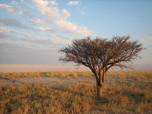
Vegetation and Landscape Zones
Vegetation reflects the extreme
salinity and aridity:
Salt pans → almost barren except for seasonal
grass after rains.
Fringing grasslands and savanna → support acacia,
palms, and baobabs.
Riverine woodland → along the Boteti (where
waterholes sustain life year-round).
Unique species include
salt-tolerant plants and iconic baobabs on rocky islands (e.g., Kubu
Island on the edge of Sua Pan, a national monument).
Makgadikgadi Pans National Park in northeastern Botswana is one of
the most extraordinary protected areas in Africa, encompassing a surreal
landscape of vast salt pans that are the desiccated remnants of an
ancient super-lake. Its history spans millions of years of geological
evolution, evidence of humanity’s deepest origins, millennia of human
adaptation, 19th-century European exploration, and modern conservation
efforts that only formalized protection in the late 20th century. The
park itself (sometimes still referred to interchangeably with the
broader Makgadikgadi Pans Game Reserve) covers approximately 3,900–4,877
km², focusing on the western end of the Ntwetwe Pan and adjacent
grasslands, while forming part of the much larger Makgadikgadi salt-pan
complex (over 16,000 km² total, with the broader landscape exceeding
30,000 km²).
Geological Origins: From Super-Lake to Salt Pans
The story begins in the Pleistocene Epoch (roughly 2 million to 11,700
years ago). A massive inland lake—Lake Makgadikgadi—once occupied much
of central Botswana. At its peak, it covered an area estimated at
60,000–80,000 km² (larger than Switzerland or even modern-day Belgium in
some reconstructions) and was fed by ancient rivers including precursors
to the Okavango and Zambezi. The basin formed through gentle tectonic
down-warping of the Earth’s crust along a northeast-southwest axis,
combined with the Kalahari Basin’s subsidence.
Over tens of thousands
of years, climate shifts toward greater aridity, combined with tectonic
activity that diverted inflowing rivers, caused the lake to shrink
dramatically. It left behind relic shorelines (most visible at
elevations around 945 m and 920 m, such as on Gidikwe Ridge west of the
Boteti River) and progressively smaller water bodies. By about
10,000–20,000 years ago in the early Holocene, the lake had largely
evaporated, concentrating salts in layers up to five meters deep and
creating the world’s largest salt-pan system. Today, the pans (primarily
Sua/Sowa, Ntwetwe, and Nxai) appear as flat, white, baked-clay surfaces
that flood briefly into shallow lakes after heavy rains, only to dry
into dust storms or mirror-like reflections. This transformation makes
the landscape a dramatic record of paleo-climatic and tectonic
processes.
Prehistoric Human Habitation: Cradle of Modern
Humanity
Archaeological and genetic evidence positions the
Makgadikgadi region as one of the most significant sites in human
prehistory. Mitochondrial DNA studies published around 2019 trace the
origin of modern Homo sapiens to this area approximately 200,000 years
ago, when it was a fertile mosaic of lakes, rivers, marshes, woodlands,
and grasslands—an ideal environment for early hominins.
Stone tools
recovered from the pans (especially along the Boteti River and at sites
like Ngxaisini Pan) include Acheulian hand-axes (associated with
pre-Homo sapiens hominins), Middle Stone Age, and Late Stone Age
artifacts. Fossiliferous deposits contain animal bones, elephant tusks,
and mammalian teeth alongside these tools, indicating long-term human
exploitation of the lake’s resources.
During the wetter early
Holocene, pastoralists herded livestock here. By the Early Iron Age,
settlements linked to the Toutswe tradition appeared at sites such as
Lekhubu (Kubu) Island, Tlapana, and Mmakgama. Historical periods show
foraging and farming communities at locations like Mosu and Kedia Hill.
One of the most remarkable features is the prehistoric settlement on
Lekhubu Island, which includes over 500 individual stone-wall structures
and 450 stone cairns of the Sotho-Tswana tradition—evidence of organized
communities adapting to a changing, increasingly arid environment. In
total, roughly 200 archaeological sites have been recorded across the
pans.
The San (Zu/’hoasi or Bushmen) people, direct cultural
descendants of these early inhabitants, have lived in the region for
thousands of years, developing deep knowledge of survival in the harsh
Kalahari. Villages such as Mopipi, Mmatshumo, Nata, Gweta, and Rakops
now fringe the pans, but the core area itself was never permanently
inhabited due to extreme aridity—only used seasonally for grazing with
government permission in modern times.
19th-Century Exploration
and European Contact
European awareness of the pans grew in the
mid-19th century. Famous explorer and missionary Dr. David Livingstone
traversed the area, and British artist-naturalist Thomas Baines
documented it vividly during his 1861–1863 journey from Namibia to
Victoria Falls with James Chapman. Baines painted the iconic baobab
trees (now known as Baines’ Baobabs and Green’s Baobabs), which served
as vital landmarks in an otherwise featureless landscape. One ancient
baobab even functioned informally as a “post office” for travelers.
These trees, some estimated at 3,000–5,300 years old, remain living
witnesses to this era of exploration.
Establishment as a
Protected Area: 1970–1992
Despite its ecological and cultural
importance, the pans remained largely unprotected until the late 20th
century. In 1970, the western end of Ntwetwe Pan and surrounding
grasslands were declared the Makgadikgadi Pans Game Reserve (3,900 km²)
to safeguard wildlife and the unique landscape. The area’s remoteness
and lack of permanent water kept human pressure low.
In 1992, the
reserve was significantly extended northward to the Maun–Nata tar road
and officially proclaimed Makgadikgadi Pans National Park under
Botswana’s Wildlife and National Parks Act of 1992, reaching
approximately 4,877 km². It now borders Nxai Pan National Park to the
north (separated only by the tar road) and forms part of a broader
conservation mosaic that includes the Nata Sanctuary in Sua Pan.
Modern Conservation Challenges and Initiatives
Protection has brought
both successes and pressures. The park is renowned for one of Africa’s
largest zebra and wildebeest migrations (second only to the
Serengeti/Mara), seasonal flamingo breeding after rains, and large herds
of antelope, elephant, lion, and other species along the Boteti River.
However, in 1992 the Boteti River was dammed upstream to supply the
Orapa Diamond Mine, reducing water flow to the pans and affecting
wildlife. In response, the Kalahari Conservation Society and the
Department of Wildlife and National Parks launched a 2006 project that
increased artificial watering holes along the Boteti from four to nine,
helping sustain the ecosystem.
The broader Makgadikgadi Pans
Landscape is on UNESCO’s Tentative List for World Heritage status,
recognized for its outstanding natural beauty, paleo-climatic record,
biodiversity (including rare plants like Hoodia and ancient baobabs),
and cultural heritage. It is safeguarded by the Monuments and Relics Act
of 2001 and Environmental Impact Assessment Act of 2005. Threats include
localized soda-ash mining on Sua Pan (since 1991), proposed river
diversions, off-road driving near flamingo breeding sites, and illegal
hunting, but community-based tourism (e.g., at Lekhubu Island managed by
the Gaing-o Community Trust) and ongoing research support long-term
preservation.
The park's biodiversity fluctuates seasonally, with harsh dry
conditions limiting life on the pans to blue-green algae and resilient
species, while wet seasons create vibrant habitats. Flora includes salt
marshes on the fringes, grasslands, and shrubby acacia savanna, with
mopane woodlands surrounding the area. Iconic baobab trees, some
millennia old like Chapman's Baobab, dot the landscape and serve as
landmarks.
Wildlife features large herbivores such as elephants,
giraffes, zebras (hosting one of Africa's largest populations with
migrations of thousands), wildebeest, oryx, springbok, impala, gemsbok,
and hippos along the Boteti River. Predators include lions, leopards,
cheetahs, hyenas (brown and spotted), and smaller carnivores like
bat-eared foxes, aardwolves, and meerkats. Reptiles abound, including
tortoises, rock monitors, snakes, lizards, and the endemic Makgadikgadi
spiny agama. The pans also support cladoceran crustaceans like Moina
belli in saltwater pools.
Avifauna is prolific during the wet season,
with migratory birds such as ducks, geese, pelicans, and one of southern
Africa's two breeding populations of greater flamingos at Sua Pan (the
other at Etosha, Namibia). Resident species include ostriches,
chestnut-banded plovers, Kittlitz's plovers, and raptors. The park's
mosaic of seasonally inundated salt-pans, grasslands, and low
tree-and-bush savanna supports this diversity, making it a key
biodiversity area.
Conservation in Makgadikgadi Pans National Park focuses on protecting
wildlife corridors for migrations, such as zebra and wildebeest routes
from the Boteti River to Ntwetwe Pan, through low-impact tourism and
community-based models. It integrates with adjacent areas like Nxai Pan
National Park and the Nata Sanctuary, supporting anti-poaching, habitat
restoration, and sustainable practices. Botswana's broader policies,
including the Kavango-Zambezi Transfrontier Conservation Area, enhance
transboundary efforts. Microbial mat diversity in the pans, influenced
by salinity and desiccation, is also studied for ecological insights.
Threats include climate change-induced droughts and erratic rainfall,
habitat degradation from overexploitation, human-wildlife conflicts near
settlements, and potential commercial exploitation of soda and salt
deposits, though limited by water and power shortages. Historical river
drying and high solar irradiance stress ecosystems, while invasive
species and wildfires pose additional risks. As of 2025, ongoing
assessments emphasize balancing biodiversity with socio-economic
development, addressing vulnerabilities in this semi-arid region.
Activities cater to adventurous travelers, including game drives to
spot predators and herds, bush walks with San guides for cultural
insights into survival techniques, quad biking on dry salt flats,
birdwatching during wet seasons, and stargazing under minimal light
pollution. Zebra migration viewing peaks in the wet season, while
dry-season walking safaris offer close encounters with meerkats. The
Kumaga Ferry provides a rustic river crossing.
Visitor information:
Access requires 4x4 vehicles due to sandy tracks, with permits from the
Department of Wildlife and National Parks. Best times are dry season
(May-October) for game viewing and quad biking, or wet season
(November-April) for migrations and birds, though roads may be
impassable. Campsites like Kumaga and Njuca Hills offer basic
facilities; luxury options include Jack’s Camp and Leroo La Tau.
Self-drivers need supplies, GPS, and multiple vehicles for safety.
The park's significance lies in preserving a unique prehistoric
landscape and supporting vital migrations, contributing to Botswana's
tourism economy while exemplifying sustainable conservation. It
symbolizes Africa's harmonious future through biodiversity protection
and community empowerment, as highlighted in 2025 scoping reviews.