Location: Map
Area: 3,000 sq km
Best time to visit: March to Sept
Moremi Game Reserve, established in 1963, is Botswana's first protected wildlife area and one of Africa's oldest reserves, spanning approximately 5,000 square kilometers in the eastern and central regions of the Okavango Delta within Ngamiland District. Named after Chief Moremi III of the BaTawana tribe, it was proclaimed a game reserve rather than a national park to allow indigenous BaSarwa (San or Bushmen) communities to continue residing within its boundaries, reflecting a unique integration of conservation and human rights. As part of the UNESCO-listed Okavango Delta, Moremi is renowned for its pristine wilderness, diverse biodiversity, and role as a "Garden of Eden" in the Kalahari Basin, supporting over 500 bird species, more than 1,000 plant species, and iconic mammals like the Big Five. Managed by the Department of Wildlife and National Parks, it emphasizes low-impact ecotourism, attracting visitors for its unparalleled safari experiences while prioritizing sustainability. By 2025, ongoing conservation initiatives, including anti-poaching strategies outlined in Botswana's National Anti-Poaching Strategy 2025-2030, continue to safeguard its ecosystems amid global challenges like climate variability.
Moremi Wildlife Reserve (also called Moremi Game
Reserve) is a premier protected area in north-western Botswana, situated
on the eastern edge of the Okavango Delta—the world’s largest inland
delta and one of Africa’s most dynamic wetland systems. Located at
approximately 19°10′S 23°10′E, it lies roughly 100–150 km north-west of
Maun (the regional gateway town) and forms a protected core where the
Delta’s permanent swamps meet drier savannah landscapes.
The
reserve spans just under 5,000 km² (about 1,900 sq mi), though some
sources approximate 3,900–5,000 km² depending on boundary definitions.
Only about 30% of it is true “mainland” (dry land), with the remainder
integrated into the Delta’s ever-shifting waterways, floodplains, and
islands. This makes Moremi unique among African reserves: it is not a
fenced park but an unfenced mosaic where wildlife moves freely between
the reserve, adjacent community concessions (such as Khwai to the
north-east), and deeper Delta areas.
Topography and Major
Landforms
The entire region is extremely flat, part of the ancient
Kalahari Basin with minimal elevation change (typically <2 m across vast
areas). The landscape is shaped by the Delta’s alluvial fan geology:
sediments deposited over millennia by the Okavango River create a
low-gradient system where water spreads rather than incises deep
channels.
Two dominant dry-land features anchor the reserve:
The Mopane Tongue (also called Moremi Tongue): A broad, finger-like
peninsula of higher, drier ground that extends westward from the eastern
mainland into the Delta’s watery heart. It forms the reserve’s
“backbone,” covered in dense to open mopane (Colophospermum mopane)
woodland on clay-rich soils. Its fringes transition dramatically into
floodplains, gallery forests, and reed-fringed channels.
Chief’s
Island: One of the Delta’s largest and most significant islands (roughly
70 km long and up to 15 km wide, ~1,000 km²). It is tectonically
uplifted along a fault line, standing slightly higher than surrounding
floodplains. This elevation makes it a critical dry-season refuge for
large mammals when floods arrive. The island features a mix of open
grasslands, shallow pans, riverine woodland, and scattered hardwoods
(leadwood, sausage tree, marula, jackalberry). Public vehicle access is
limited (much of it falls under private concessions like Mombo), but it
is visible and explorable from water or air.
Other notable
features include:
Seasonal pans and shallow depressions (such as
those near the Mababe Depression on the eastern fringe, a fossil
riverbed that occasionally pools water).
Numerous small, palm-ringed
islets and raised sandbanks within the swamps.
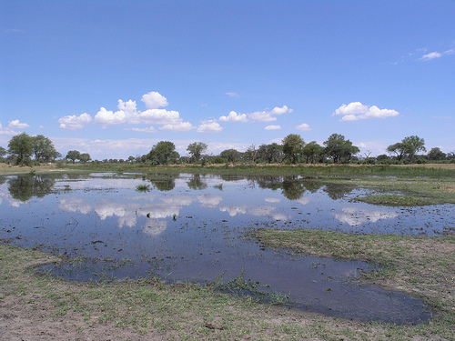
Hydrology and
Water Systems
Moremi sits at the heart of the Okavango Delta, an
endorheic (closed-basin) system where the Okavango River (originating as
the Cubango in Angola’s highlands, ~1,000–1,600 km away) fans out into
Botswana’s Kalahari sands and never reaches the sea. Water evaporates or
infiltrates the desert, sustaining one of the planet’s largest oases.
Key hydrological elements inside or defining Moremi include:
Permanent channels and swamps: Deep, reed- and papyrus-lined waterways
(e.g., Nqoga, Khwai, and parts of the Jao/Boro systems) that maintain
year-round water. These support hippo highways, lily-covered lagoons,
and crystal-clear pools.
Seasonal floodplains and marshes: Vast
grasslands that flood annually when Angolan rains (peaking
December–March) push water downstream, arriving in Botswana during the
dry season (May–August/September). Flood extent varies yearly but can
inundate hundreds of square kilometres, creating interconnected lagoons
and shallow pans.
Major rivers and boundaries: The northern edge
roughly follows the Nqoga–Khwai river system (lush floodplains and
gallery forests). Southern boundaries are defined by the Jao, Boro, and
Gomoti Rivers. The Khwai River is a perennial lifeline on the
north-east.
Iconic water features: Xakanaxa Lagoon (at the Mopane
Tongue’s tip, a mosaic of permanent swamp and seasonal plains), Third
Bridge (over the Moanachira River, amid channels and thickets), and
lily-dotted lagoons ringed by papyrus.
The Delta’s pulse—high
water in the dry season, receding floods in the wet season—drives the
entire geography, creating startling contrasts: one moment you drive
through dusty mopane woodland; the next, you cross knee-deep floodplains
or pole a mokoro (traditional canoe) through papyrus channels.
Ecosystems and Landscape Mosaic
Moremi’s geography is defined by its
extraordinary habitat diversity—no other African reserve compresses so
many ecosystems into such a compact area:
Mopane and acacia
woodlands — On drier soils and the Mopane Tongue; dense stands give way
to open savannah with scattered sausage trees and leadwoods.
Riverine
forests and gallery woodlands — Tall, shady belts along permanent
channels, rich in hardwoods.
Permanent swamps and reed beds —
Dominated by papyrus (Cyperus papyrus), Phragmites reeds, bulrushes, and
aquatic grasses.
Seasonal floodplains and grasslands — Open savannahs
and short-grass plains that green up dramatically with flood arrival;
ideal for grazers like red lechwe.
Lagoons and open water —
Lily-covered pools and shallow pans teeming with aquatic life.
Islands and sandveld — Wooded or grassy raised areas with Kalahari-style
vegetation.
This seamless transition from dry woodland to wetland
supports exceptional biodiversity and year-round wildlife
concentrations.
Climate and Seasonal Dynamics
The reserve
experiences a semi-arid subtropical climate modulated by the Delta:
Wet season (November–April): Thunderstorms bring 450–500 mm of rain;
temperatures are warm (daytime highs ~28–32°C), vegetation lush, and
flooding from local rains adds to the Delta pulse.
Dry season
(May–October): Cooler winters (June–August nights can drop to ~10–15°C)
transition to hot, dry conditions (October peaks at 34–39°C). Annual
floods from Angola arrive, peaking May–August and transforming the
landscape into a green oasis while surrounding areas dry out.
Flood timing creates the reserve’s signature geography: wildlife
concentrates around permanent water in the dry season, while the wet
season spreads animals across newly flooded plains.
Boundaries
and Context
Moremi is unfenced and contiguous with:
Chobe National
Park to the north-east (via the Khwai corridor).
Community-managed
wildlife areas (Khwai, NG/26 concessions).
The wider Okavango Delta
(much of which is protected in wildlife management areas).
Entry
points include the South Gate (near Maun/Shorobe road) and North Gate
(Khwai area). The reserve was established in 1963 by the BaTawana people
(named after Chief Moremi III) to safeguard this unique land–water
interface; later expansions incorporated royal hunting grounds.
Moremi's flora is exceptionally diverse, with over 1,000 plant species forming the backbone of its ecosystems, from dense riparian woodlands to floodplain grasses. Dominant trees include mopane (Colophospermum mopane) in southern woodlands, acacias (Acacia spp.) in savannas, ebony (Diospyros mespiliformis), and sausage trees (Kigelia africana) in forested areas, traditionally used for mokoro canoes but now protected through fiberglass alternatives. Floodplains support lush grasses like Cynodon dactylon and sedges, while pioneer species such as Croton megalobotrys have increased due to elephant-induced woodland degradation. Riparian zones feature water-loving plants like papyrus (Cyperus papyrus) and figs (Ficus spp.), contributing to habitat stability. Vegetation shifts from 1967 to 2001 show declines in preferred browse species and episodic recruitment patterns (e.g., bell-shaped or U-shaped), influenced by herbivory and fire, posing risks to long-term floral diversity. The reserve's undisturbed state preserves this botanical richness, supporting ecosystem services like soil nutrient cycling and water filtration.
Moremi boasts one of Africa's richest wildlife assemblages, including the Big Five: African elephant (large herds, often 100+), lion (prides resting in plains), leopard (in wooded areas), African buffalo, and both black and white rhinoceros (reintroduced to complete the set). Other mammals include giraffe, plains zebra, blue wildebeest (annual migrations), impala, red lechwe (adapted to wetlands), common warthog, hippopotamus, cheetah (tree-climbing for kills), spotted hyena, black-backed jackal, and endangered African wild dog (studied since 1989, with collared packs). Avifauna exceeds 500 species, featuring waterbirds like slaty egret, wattled crane, African fish eagle, herons, lilac-breasted roller, secretary bird, and rare Pel's fishing owl. Reptiles such as Nile crocodiles thrive in lagoons, while smaller fauna like monitor lizards and insects support the food web. Seasonal concentrations around water sources from July to October enhance sightings, with predators like wild dogs and cheetahs highlighting the reserve's "predator paradise" status.
As a UNESCO World Heritage component of the Okavango Delta, Moremi is protected under Botswana's Wildlife Conservation and National Parks Act, with considerations for inclusion in the Kavango-Zambezi Transfrontier Conservation Area. Conservation efforts include anti-poaching patrols, habitat management, community involvement, and sustainable tourism via low-impact lodges and guided activities. Key programs focus on species like African wild dogs and rhinos, with reintroductions bolstering populations. Threats include escalating poaching, particularly for rhino horn (46 rhinos killed in 2019-2020, nearly 10% of Botswana's population), driven by high black-market values up to $60,000 per kilogram. Herbivory pressure from elephants and other large mammals has led to woodland degradation, with increases in less-preferred species like Croton megalobotrys and declines in favored browse from 1967-2001, reducing habitat capacity and biodiversity. Climate change exacerbates floods and droughts, while tourism growth risks habitat disturbance; mitigation involves adaptive strategies like fire management and episodic recruitment monitoring. By 2025, the National Anti-Poaching Strategy emphasizes community-based monitoring and international partnerships to address these issues.
Moremi Game Reserve (also known as Moremi Wildlife
Reserve) is one of Africa’s most iconic protected areas, located in the
eastern sector of the Okavango Delta in Botswana. It spans approximately
4,871–5,000 km² (about 20–40% of the delta depending on seasonal
flooding and boundaries) and is renowned for its exceptional
biodiversity, including predators, elephants, and rare species like
African wild dogs. Unlike many African national parks established
top-down by colonial authorities, Moremi stands out as the continent’s
first major wildlife sanctuary created through community initiative by
an indigenous group—the BaTawana (Batawana) people of Ngamiland—in
partnership with local conservationists.
Its history reflects a
unique blend of traditional tribal governance, grassroots conservation
amid mid-20th-century threats, expansions under evolving management, and
ongoing tensions between wildlife protection, tourism, and local
communities. Below is a detailed chronological account drawn from
historical records, official sources, and scholarly accounts.
Pre-Colonial and Early Indigenous Use (Ancient Times to Early 20th
Century)
The land that became Moremi has supported human activity for
millennia. Archaeological and oral histories indicate that San (Basarwa
or Bushmen) hunter-gatherer communities hunted in the region as far back
as 10,000 years ago, utilizing the delta’s floodplains, islands, and
waterways for sustenance. By the 19th century, the BaTawana—a Tswana
subgroup—had established control over Ngamiland (the northwestern region
of what was then the Bechuanaland Protectorate). The area, including
what is now Chief’s Island (one of the delta’s largest and most
wildlife-rich features), served as traditional hunting grounds for
BaTawana chiefs. Wildlife was abundant, and tribal authorities held
customary rights to manage and benefit from game resources, with some
revenues from hunting concessions flowing to tribal coffers.
Mid-20th Century Threats and the Rise of Conservation Awareness
(1950s–Early 1960s)
By the 1950s, the Okavango Delta’s wildlife faced
severe pressure. Uncontrolled commercial and recreational
hunting—particularly by illegal South African parties and European
sportsmen—combined with expanding cattle grazing, rapidly depleted game
populations and encroached on ancestral lands. Local BaTawana leaders
grew alarmed that their traditional hunting grounds and the delta’s
ecological richness were at risk of irreversible damage.
A pivotal
network emerged involving BaTawana chiefs and a group of white
hunters-turned-conservationists (often described as “adventurers”). Key
figures included Robert and June Kay, who shifted from hunting to
advocacy, along with the newly formed Ngamiland Fauna Conservation
Society. This coalition campaigned for formal protection, viewing a
reserve as a way to safeguard wildlife from external exploitation while
preserving future local benefits. Notably, the colonial British
administration (Bechuanaland Protectorate) initially opposed the idea,
preferring centralized control; Moremi thus became an exception to the
typical colonial imposition of parks elsewhere in Africa.
Founding and Proclamation (1963)
The reserve was officially
proclaimed on 15 March 1963—three years before Botswana’s independence
in 1966. It was named after Chief Moremi III of the BaTawana (who had
died earlier), at the initiative of his widow and regent, Elizabeth
Pulane Moremi (also known as Mrs. Moremi or Pulane Moremi). As regent
from 1946 to 1964, she played a decisive leadership role: a progressive
figure who shepherded community support through traditional kgotla
(tribal council) meetings, persuading the BaTawana to set aside land for
conservation.
Initially, the reserve covered the “Mopane Tongue” (a
triangular area roughly 30 km by 65 km, focused on drier woodland and
floodplain edges from the Khwai River to the Mogogelo River). It was
designated a game reserve (not a stricter national park) to allow
limited traditional use by resident San communities and to respect
tribal land rights. Management was entrusted to the Fauna Conservation
Society of Ngamiland, marking it as Africa’s first community-led
conservation initiative of its scale.
This was a bold, locally driven
act of foresight. As one official account notes, the BaTawana acted
“under the leadership of the deceased Chief Moremi III’s wife, Mrs
Moremi,” to counter “rapid depletion of wildlife in their ancestral
lands – due to uncontrolled hunting and cattle encroachment.”
Early Management and Initial Expansions (1960s–1970s)
The Fauna
Conservation Society ran the reserve in its early years, with some
involvement from international conservation networks. However, the
creation led to the relocation of certain San (Basarwa) groups who had
lived within the boundaries; communities were resettled to villages like
Khwai, Ditshiping, and Xaxaba to prioritize wildlife protection and
emerging tourism. These moves, carried out around 1963, have remained a
point of historical tension, with later generations advocating for
greater inclusion in benefits and decision-making.
In the 1970s
(specifically around 1970), after further negotiations with the tribe,
the reserve expanded significantly to incorporate Chief Moremi’s
traditional royal hunting grounds, including the iconic Chief’s Island—a
raised ancient floodplain now one of the delta’s premier wildlife zones.
This brought the area to roughly 3,800 km².
Government Takeover
and Further Growth (1979–1990s)
By the late 1970s, as Botswana’s
post-independence government developed its wildlife and tourism
policies, management shifted. In 1979, the reserve was transferred to
the Department of Wildlife and National Parks (DWNP), centralizing
administration under the state while maintaining its game reserve
status.
Additional expansions followed: in the early 1980s (around
1981) and confirmed by some accounts in 1991, a northwestern strip
between the Jao and Nqoga rivers was added. This ensured representation
of all major delta habitats (floodplains, woodlands, lagoons) and
increased the reserve to its current size of nearly 5,000 km².
Modern Era (1990s–Present): Conservation Legacy and Challenges
Moremi’s pioneering model influenced Botswana’s broader community-based
natural resource management (CBNRM) policies. The entire Okavango Delta,
including Moremi, was inscribed as a UNESCO World Heritage Site in 2014
for its outstanding universal value as a wetland ecosystem. In 2008, it
was voted “best game reserve in Africa” by the African Travel and
Tourism Association.
Today it remains a cornerstone of Botswana’s
low-impact, high-value safari tourism, with limited lodges and emphasis
on eco-friendly access (4x4 drives, mokoro canoes, walking safaris).
Wildlife thrives here—home to lions, leopards, elephants, wild dogs (a
significant portion of the global population), and the only sanctuary in
Botswana for white rhinos in some periods—though challenges persist,
including poaching spikes (e.g., a 2019 rhino crisis) and debates over
community benefits from relocations decades earlier.
Recent
discussions (e.g., around the Fauna Conservation Trust of Ngamiland)
have revisited historical grievances, with some communities seeking
greater involvement in management and revenue sharing.
Moremi integrates human elements through its allowance for BaSarwa and Batawana communities to reside and engage in traditional practices, fostering cultural heritage like crafts, dances, and cuisine that support local economies. Community trusts and painted dog conservation programs educate residents and visitors, promoting symbiosis between people and nature. Tourism adheres to a high-yield, low-impact model, with only four public campsites (South Gate, Third Bridge, Xakanaxa, Khwai) and private lodges like Xakanaxa Camp or Moremi Crossing on the outskirts, accessed via light aircraft or 4x4 vehicles. Activities include game drives (morning, afternoon, night) for spotting elephants and lions, mokoro canoe trips poled by guides through waterways for hippos and birds, walking safaris in designated zones for immersive tracking, boat safaris, helicopter/hot air balloon flights, and catch-and-release fishing. Best visited July-October for wildlife concentrations, though year-round appeal exists; visitors should prepare for malaria, water crossings (snorkels advised), and eco-guidelines. In 2025, tourism supports local livelihoods while funding conservation, with cultural visits enhancing experiences.