Location: Ngamiland District, Botswana
Tsodilo Hills, located in northwestern Botswana's Ngamiland District near the Namibian border, is a UNESCO World Heritage Site renowned for its extraordinary concentration of rock art and profound cultural significance. Spanning just 10 square kilometers, the site features over 4,500 ancient rock paintings, earning it the nickname "Louvre of the Desert." Inscribed on the UNESCO list in 2001 under criteria (i), (iii), and (vi), Tsodilo represents a unique record of human settlement, environmental adaptation, and spiritual practices spanning at least 100,000 years. The hills rise dramatically from the Kalahari Desert, serving as a sacred landscape for local San (also known as Basarwa or Bushmen) and Hambukushu communities, who view them as a dwelling for ancestral spirits. Managed by the Department of National Museum and Monuments in collaboration with the Tsodilo Community Trust, the site integrates conservation with community involvement, attracting researchers, tourists, and spiritual pilgrims. As of 2025, Tsodilo remains a vital symbol of Botswana's heritage, with ongoing efforts to balance tourism growth and preservation amid environmental challenges like climate change.
Topography and Landforms
The hills consist of four main quartzite
massifs that stand out as prominent residual hills (inselbergs) amid an
otherwise pancake-flat desert plain. Locals and visitors traditionally
name them according to San (and later Hambukushu) mythology as a
“family”:
Male Hill (also called Father Hill): the tallest and
most imposing, reaching approximately 1,375–1,400 m above mean sea level
(AMSL). It rises roughly 400 m (about 1,312–1,400 ft) above the
surrounding Kalahari floor, making it one of Botswana’s highest points
(though national rankings vary slightly due to SRTM data margins of
error).
Female Hill: the second-largest, with gentler slopes and more
shelters.
Child Hill.
Grandchild (or an unnamed small knoll): the
smallest, located about 2.1 km northwest of the main cluster.
The
three largest hills cluster within a roughly 3 km × 10 km rectangle. The
entire formation is visible from up to 40 km away, including from the
Okavango River to the northeast.
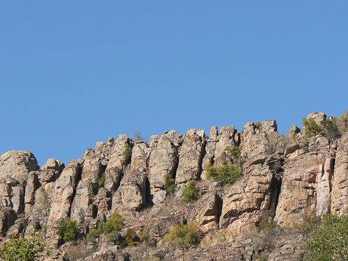
The topography features steep rocky
cliffs, deep caves, rock shelters, depressions, and weathered outcrops.
Trails, grooves, and water-worn channels scar the surfaces—some natural,
others culturally significant. The hills create a dramatic visual and
topographic contrast: from the surrounding arid plains, they appear as
copper-colored sentinels streaked with mauve, turquoise, lavender, and
pink hues from mineral staining.
Geology
Tsodilo’s rocks
belong to ancient, highly resistant quartzite formations (metamorphosed
sandstones), with associated minor pebbly metasandstones, quartz-mica
schists, and meta-conglomerates of Neoproterozoic to Lower Paleozoic
age. Tectonic uplift and millions of years of differential erosion have
left these durable quartzitic outcrops standing as inselbergs while
softer surrounding sediments eroded away. The quartzite’s high silica
content and metamorphic hardening give it exceptional resistance to
weathering—key to the site’s long-term preservation and the survival of
thousands of rock paintings.
The multicolored streaking results from
iron oxides, manganese, and other minerals. The hills also contain
natural cavities, shelters, and depressions formed by chemical
weathering and wind abrasion typical of arid environments.
Surrounding Physiography
To the east lie ancient stabilized sand
dunes (linear and parabolic forms) mantled with Kalahari-type
vegetation. To the west stretches a broad, flat dry fossil lake bed
(Palaeolake Tsodilo), a relic of much wetter Pleistocene conditions when
the lake covered up to ~70 km² during humid phases.
The broader
region is part of the vast Kalahari Basin—an immense interior
sand-filled depression covering much of southern Africa. Locally, the
terrain is extremely flat (Botswana is one of the world’s flattest
countries), with elevations around 1,000 m AMSL in the surrounding
plains. This isolation and prominence made Tsodilo a natural landmark
and resource oasis for millennia.
Climate
Tsodilo lies in a
semi-arid to arid subtropical climate (Köppen BSh/BWh) typical of the
Kalahari. Mean annual rainfall is low (roughly 400–600 mm), concentrated
in a short summer wet season (November–March) with high variability and
frequent droughts. Temperatures are extreme: summer daytime highs often
exceed 35–40 °C, while winter nights (May–August) can drop near
freezing. The dry winter months offer the most comfortable conditions
for visiting and hiking, with clear skies and lower dust. Evaporation
far exceeds precipitation, contributing to the harsh environment.
Hydrology
Surface water is scarce, reinforcing the hills’
cultural and practical importance. A natural perennial spring near
Female Hill serves as the only reliable water source for many kilometers
and remains a ritual site today. Additional seasonal waterholes and rock
depressions collect rainwater. In the Late Pleistocene, Palaeolake
Tsodilo provided a much larger, more permanent water body, supporting
richer vegetation and human occupation during wetter climatic phases
(evidenced by lake sediments and archaeological layers).
Vegetation and Soils
The surrounding landscape supports Kalahari
scrub bush and open savannah: acacia and mopane trees, thorny shrubs,
grasses, and drought-resistant species such as tsamma melons and wild
tubers that sustained hunter-gatherer communities. Soils are
predominantly nutrient-poor Kalahari sands (Arenosols) with limited
organic matter, except in sheltered rock-base areas or ancient lake beds
where finer sediments occur. Vegetation density increases slightly near
the hills due to minor runoff and shade.
Palaeogeographic Context
Sediment cores and archaeological evidence reveal major environmental
shifts: during the Late Pleistocene, the region experienced repeated
wet–dry cycles linked to Indian Ocean monsoon variability and global
climate changes. Palaeolake Tsodilo expanded and contracted, influencing
human settlement patterns for at least 100,000 years. Today’s arid
conditions contrast sharply with these wetter phases, yet the hills’
durable geology preserved a continuous record of these changes.
In
summary, Tsodilo Hills represent a rare topographic, geological, and
hydrological anomaly in the monotonous Kalahari—a “Louvre of the Desert”
whose quartzite inselbergs, fossil lake setting, and scarce springs have
shaped both the physical landscape and human history for over 100
millennia. Their remoteness, erosional resistance, and cultural
significance have kept the site remarkably intact.
Flora at Tsodilo is adapted to the Kalahari's arid conditions, featuring drought-resistant species like mongongo trees (Schinziophyton rautanenii), whose nuts have been a staple for inhabitants for millennia, as evidenced by archaeological finds. Other vegetation includes acacias, mopane shrubs, and grasses that form sparse woodlands and scrub bush, with ilala palms used by local communities for basket weaving. The site's plant life supports limited but diverse fauna, including small antelopes like kudu (Tragelaphus strepsiceros) and steenbok (Raphicerus campestris), as well as reptiles such as pythons and monitor lizards. Bird species are present, though not a primary focus, with squirrels and insects like beetles thriving in the rocky terrain. Rock art depictions highlight historical fauna, including elephants, giraffes, rhinos, and cattle, suggesting richer biodiversity in wetter past eras. While not a wildlife viewing destination like Botswana's deltas, the site's ecology underscores human adaptation, with taboos against hunting near the hills preserving local species. As of 2025, climate variability poses risks to vegetation, with studies noting shifts in hydrological settings affecting plant and animal distributions.
Tsodilo boasts one of the world's densest collections of rock art, with over 4,500 paintings across more than 500 sites, spanning from the Stone Age to the 19th century. The art includes red finger paintings (often older, linked to San peoples) depicting wild animals, geometrics, and schematic designs, and white paintings (associated with Bantu groups) showing domestic cattle, human figures, and horseback scenes post-1800s. Key sites include Rhino Cave (with white rhino and giraffe depictions, debated for 70,000-year-old ritual claims, later critiqued as more recent), White Paintings Rock Shelter, and Depression Rock Shelter. Archaeological evidence reveals Middle Stone Age (MSA) tools from 30,000 years ago, Later Stone Age (LSA) artifacts, and Early Iron Age settlements like Divuyu (700-900 AD) and Nqoma, with iron and copper jewelry, glass beads, and seashells indicating extensive trade networks. Over 20 specularite mines highlight ancient cosmetic and trade practices, while sediments provide paleo-environmental data over 100,000 years. The site's chronology documents human evolution, from hunter-gatherers to pastoralists, with influences from European contact (e.g., nylon buttons, glass beads).
For the San and Hambukushu peoples, Tsodilo is a sacred cultural landscape, revered as the birthplace of life and a realm of ancestral spirits, with taboos prohibiting hunting or harm nearby. Oral traditions describe rituals for rain-making, healing, and hunting success, with a natural spring near Female Hill used for cleansing and protection, symbolizing creation where the first animals left paths (grooves in the rock). The hills' symbolic power persists, with communities practicing intangible heritage that authenticates the site's Outstanding Universal Value. Rock art's meanings—often mystical or ritualistic—remain enigmatic, linking to spiritual beliefs, while the site's name derives from local lore associating the hills with a family structure.
Earliest Human Occupation (Middle Stone Age and Earlier)
Archaeological evidence shows human presence dating back at least
100,000 years (possibly earlier), making Tsodilo one of the longest
continuously occupied sites in southern Africa. The earliest occupants
were likely Middle Stone Age (MSA) hunter-gatherers who used the hills
for shelter, tool-making, and resources during a time when the region
was wetter, with rivers, lakes, and abundant wildlife.
Key
excavations, especially at White Paintings Rock Shelter (on Male Hill)
and Rhino Cave (north end of Female Hill), reveal deep stratigraphy up
to 7 meters. MSA layers contain large stone blades, prepared projectile
points, and evidence of long-distance exchange (local quartz alongside
exotic stones). People exploited freshwater fish (barbed bone points
suggest spears), wild plants, and game. The now-arid landscape once
supported a more diverse ecosystem, and the hills’ impermeable quartzite
collected vital rainwater in depressions and pools.
By the Late Stone
Age (LSA, ~70,000–30,000 years ago), occupation intensified seasonally,
possibly tied to the ripening of mongongo nuts (a staple still important
today). Ostrich eggshell beads appear around 30,000 BP, a tradition that
continues among San communities. Fish exploitation declined as the
climate dried, and toolkits shifted to microliths, grindstones, and
hammerstones. Grooves and cup-like depressions in the rock (some forming
trails resembling animal footprints) date to this era and may relate to
ritual or practical grinding.
Rock Art: A Chronicle Spanning
Millennia
Tsodilo contains over 4,500 individual paintings (and
additional engravings/carvings) across ~500 sites— one of the highest
densities anywhere. Paintings appear in shelters, caves, and overhangs
on all four hills and span from the Stone Age to the 19th century. Most
are in red ochre (made from local haematite mixed with binders like fat,
blood, or plant sap), executed with fingers or brushes in naturalistic,
schematic, or geometric styles.
Subjects: Predominantly large
wild herbivores (giraffe, rhino, eland, zebra, elephant), some domestic
animals (cattle, sheep), human figures (sometimes with hands on hips or
on horseback), and geometric patterns (grids, lines, circles). Scenes
are rare; many panels are isolated or frieze-like. Cattle depictions
help date later art to ~800–1200 AD.
Techniques and Evolution: Early
art is mostly red finger paintings by San hunter-gatherers (ancestral to
today’s Ju/’hoansi). Later white paintings (superimposed on reds) are
linked to Khoi-speaking herders and isi-Ntu/Bantu farmers who arrived in
the last ~3,000 years. Styles differ from other southern African
sites—more schematic and resembling central African traditions
(Zambia/Angola).
Dating: Exact ages are difficult (paintings lack
organic material for direct dating), but most are estimated
10,000–20,000 years old, with some possibly older and others as recent
as the 19th century. Cattle images align with Iron Age herding
(~600–1200 AD); geometric designs ~1,000 years old.
The art is
not merely decorative; it reflects spiritual beliefs, environmental
knowledge, and possibly shamanic visions or rituals. For the San, it
connects the living to ancestral realms and serves as a visual
repository of cultural memory.
Later Prehistory and Iron Age (c.
600–1300 AD)
Around the 7th century AD, Early Iron Age Bantu
agro-pastoralists arrived from central Africa, introducing cattle,
sheep, goats, sorghum/millet cultivation, pottery, and metallurgy. Two
major settlements—Divuyu (saddle on Female Hill, ~700–900 AD) and Nqoma
(plateau below, continuing to ~13th century)—reveal sophisticated
communities. Excavations uncovered house foundations, middens, burials,
iron-smelting slag, tuyères, and extensive copper/iron jewelry (bangles,
beads, chains) traded from the Congo, Angola, and even Asia (glass
beads). Over 20 specularite mines supplied glittering iron-oxide for
cosmetics and trade.
These sites show unique spatial organization
(central public housing flanked by middens and burials) unlike typical
southern African Iron Age patterns, indicating cultural blending with
local foragers. Interaction between San hunter-gatherers and incoming
farmers/herders was extensive, with shared resources and intermarriage
over time.
Mythology, Spiritual Significance, and Living
Traditions
For the San (Ju/’hoansi), Tsodilo is the “birthplace of
life” and a sacred mausoleum for ancestral spirits. The hills themselves
form a spiritual family: Male (highest and most sacred), Female (source
of power and spirits), Child, and sometimes First Wife. Deep impressions
atop Male Hill are said to be the first spirit’s prayer marks after
creating the Earth. Grooves and trails mark the paths of the first
animals to a watering hole. Female Hill houses ruling spirits; a sacred
spring provides water for cleansing and healing.
Shamans perform
trance dances for healing and ancestor communication. Rain-making
rituals and prayers for successful hunts occur here. The Hambukushu (who
settled nearby ~200 years ago) also revere the site as a place of
worship. Both groups consider disturbing the hills (e.g., hunting nearby
or removing artifacts) taboo, as spirits may cause misfortune.
Historical Period and Western “Discovery”
San (!Kung/Ju/’hoansi) and
Hambukushu occupied the area into the 19th century. European awareness
grew in the mid-1800s via David Livingstone’s travels (1849–1856); the
hills were first sketched in 1907 by Siegfried Passarge. Laurens van der
Post’s 1958 book The Lost World of the Kalahari popularized the San
paintings (one panel is named after him) and highlighted their spiritual
world.
Modern Era: Protection, Challenges, and Tourism
Declared a national monument in 1927 (later reinforced in 1995), Tsodilo
became Botswana’s first UNESCO World Heritage Site in 2001. A museum,
campsites, and guided-tour system (mandatory to protect the art) now
manage visitation. The Department of National Museum and Monuments
oversees it with community input via the Tsodilo Management Authority.
In 1995, a small Ju/’hoansi community was relocated from the hill base
to a village ~3 miles away to create a conservation area. While tourism
provides income (craft sales, guiding), it has restricted traditional
access to resources, grazing, and some rituals, leading to cultural
erosion, economic dependency, and social issues. The San emphasize their
role as original custodians, and ongoing management plans balance
preservation with community rights.
Today, Tsodilo remains a living
cultural landscape: elders still visit for prayer and meditation, and
the site offers profound insight into humanity’s deep-time relationship
with the environment—from Stone Age foragers to Iron Age metallurgists
to contemporary indigenous custodians. Its rock art, archaeology, and
oral traditions together chronicle not just survival but a symbiotic,
spiritually rich coexistence with one of Africa’s most ancient sacred
places.
Protected under Botswana's Monuments and Relics Act (2001), Anthropological Research Act (1967), National Parks Act (1967), and Tribal Act (1968), Tsodilo's management involves the Tsodilo Management Authority, including the Community Trust and NGOs. Integrated plans from 1997, 2007 (buffer zone), and 2009 (core area, with African World Heritage Fund aid) emphasize preventive conservation, community initiatives, and monitoring. Integrity is upheld by remoteness and low population, with boundaries encompassing all key elements. Threats include rising visitor numbers causing litter and potential vandalism (mitigated by guided tours), natural deterioration of art, and climate impacts like droughts altering hydrology. UNESCO's periodic reporting and grants, such as 2024-2025 COMPACT funding for biodiversity via UNDP, support sustainable practices.
Local San and Hambukushu communities (relocated from the hills pre-2001) engage in subsistence farming, basket weaving (using ilala palms, sold via cooperatives), and guiding, benefiting from trust-managed entrance fees. Tourism, growing post-UNESCO inscription, offers guided hikes on trails like Rhino (featuring art and caves), Lion, and Cliff, with fees (e.g., 50 BWP adults, plus guide costs) supporting the community. Facilities include a museum, campsite with ablutions, picnic areas, and an airstrip; visitors explore art, hike (e.g., Male Hill summit in 35 minutes), view wildlife, and visit villages or cooperatives. Access requires a 4x4 vehicle on rough roads from Shakawe (1-2 hours), with nearby lodges like Drotsky's Cabins. Activities emphasize cultural immersion, with events like the 2021 Heritage Challenge Walk promoting awareness. As of 2025, tourism impacts are monitored to ensure sustainability, blending heritage education with economic benefits for locals.