Location: 50 km West of Bukavu Map
Area: 4,920 km²
Kahuzi-Biéga National Park is a UNESCO World Heritage Site located in the eastern Democratic Republic of the Congo (DRC), near Bukavu town on the western bank of Lake Kivu and bordering Rwanda. Spanning approximately 6,000 square kilometers, it is one of the largest protected areas in the Congo Basin and a critical biodiversity hotspot in the Albertine Rift Valley. Established primarily to safeguard the critically endangered eastern lowland gorilla (Gorilla beringei graueri), also known as Grauer's gorilla, the park encompasses a unique transition from lowland rainforests to highland ecosystems, dominated by two extinct volcanoes: Mount Kahuzi (3,308 meters) and Mount Biega (2,790 meters). Designated a World Heritage Site in 1980 and placed on the List of World Heritage in Danger in 1997 due to ongoing conflicts and threats, the park symbolizes both ecological richness and the challenges of conservation in a politically unstable region. As of 2025, it remains a focal point for gorilla tourism and international efforts to combat deforestation, poaching, and armed incursions, despite persistent security issues.
Location and Size
The park lies in South Kivu Province,
approximately 30 km west of the Rwandan border and immediately west of
Bukavu town on the western shore of Lake Kivu. Its central coordinates
span roughly 1°36' to 2°37'S and 27°33' to 28°40'E. It covers a total
area of about 600,000 hectares (6,000 km² or 2,300 sq mi), making it one
of the largest national parks in the DRC.
Geographically, it is
divided into two distinct sectors connected by a narrow 7.4 km (4.6 mi)
corridor of rolling terrain:
Eastern highland sector (~600 km² /
60,000 ha): Located in the Mitumba Mountains, part of the Albertine Rift
within the western branch of the Great Rift Valley.
Western lowland
sector (~5,400 km² / 540,000 ha): Extending westward toward Kisangani on
the fringes of the Congo Basin.
This corridor links the
mountainous and lowland zones, preserving an unbroken ecological
gradient.
Topography and Geology
The park's topography is
highly varied, ranging from rugged volcanic peaks to undulating
lowlands. It straddles the tectonic boundary of the Albertine Rift (a
zone of active rifting) and the stable Congo Basin, resulting in
dramatic elevation changes over short distances.
Highest points:
Two prominent extinct volcanoes dominate the eastern sector—Mount Kahuzi
(3,308 m / 10,853 ft) and Mount Biéga (2,790 m / 9,150 ft). These late
Tertiary to early Quaternary volcanoes form part of the Mitumba massif
on the western flank of the Rift Valley.
Lowland areas: The western
sector features low mountains and hills generally below 1,500 m, with
isolated peaks such as Mount Kamami (1,700 m). The terrain is
undulating, cut by deep river valleys, and slopes gently in places.
Overall elevation range: From approximately 600–700 m in the western
lowlands to 3,308 m at Mount Kahuzi's summit. Mean elevation in the
highlands is around 1,500 m, while the lowlands average lower.
The geology reflects rift-related volcanism in the east (forming steep
slopes and crater features) and sedimentary/erosional processes in the
west. Surficial deposits include minerals like gold, cassiterite, and
coltan, though these are not central to the park's natural geography.
Climate
Kahuzi-Biéga experiences a tropical rainforest climate
(Af in the Köppen system) modified by altitude. Conditions are humid
year-round with high rainfall and relatively stable temperatures, though
cooler and more variable in the highlands.
Annual rainfall
averages 1,800–1,900 mm, with wide local variation. A drier period
occurs from June to August.
Temperatures: In the Mitumba highlands,
annual maxima average around 15–18°C and minima ~10.4°C. Lowland areas
are warmer but still moderated by forest cover.
Fog and mist are
common at higher elevations, contributing to the lush vegetation.
Hydrology
The park is well-drained by tributaries of the upper
Congo River system. In the western sector, the Luka and Lugulu rivers
(and their tributaries) flow through deep valleys into the Lualaba River
(the upper course of the Congo).
Hydromorphic (waterlogged) soils
support extensive swamps, bogs, marshlands, and riparian forests at all
altitudes. High-altitude peat bogs occur above ~2,000 m, while lowland
areas feature riverine wetlands. A 2020 survey noted three main drainage
basins supporting rich freshwater fish diversity. Waterfalls and streams
are common in the dissected terrain.
Vegetation and Ecosystems
One of the park's most striking geographical features is its continuous
vegetation continuum across an altitudinal range of ~600 m to over 2,600
m—one of the few such intact gradients in sub-Saharan Africa. This
creates a mosaic of distinct biomes, from dense lowland equatorial
rainforest to afro-alpine formations.
Key vegetation zones
(primarily in the eastern sector, with parallels in the west):
Lowland rainforest (600–1,200/1,350 m): Dense Guineo-Congolian wet
equatorial forest, dominated by species like Michelsonia microphylla and
Gilbertiodendron dewevrei. Part of the Northeastern Congolian lowland
forests ecoregion.
Transition/mid-altitude forests (1,200–2,000 m):
Sub-montane and montane rainforests with species such as Pentadesma
lebrunii, Lebrunia bushaie, Podocarpus usambarensis, and others.
Bamboo forests (2,350–2,600 m): Dense stands of Arundinaria alpina.
High-altitude and sub-alpine zones (>2,600 m): Sub-alpine prairies,
heather (Erica rugegensis, Vaccinium stanleyi), and afro-alpine
elements, including the endemic Senecio kahuzicus. Tree line is around
2,600 m.
Wetlands and special formations: Swamp forests (e.g.,
dominated by Syzygium rowlandii), peat bogs (with Cyperus spp.,
Sphagnum), and riparian forests on hydromorphic soils throughout.
Over 1,178 plant species have been recorded, with high endemism. The
park lies in a global Centre of Plant Diversity and supports rare
habitats like high-altitude peat bogs.
Kahuzi-Biéga National Park (often written as Kahuzi-Biega) is a vast
protected area in eastern Democratic Republic of the Congo (DRC),
spanning approximately 6,000 km² (600,000 hectares) across the South
Kivu and Maniema provinces near the western shore of Lake Kivu and the
Rwandan border. It is renowned for its primary tropical rainforest, two
dramatic extinct volcanoes (Mount Kahuzi at 3,308 m and Mount Biéga at
2,790 m), and as one of the last strongholds for the critically
endangered eastern lowland gorilla (Grauer’s gorilla, Gorilla beringei
graueri). Its history is a complex narrative of colonial conservation
roots, post-independence expansion, biodiversity triumphs, and profound
challenges—including forced evictions of Indigenous peoples, armed
conflicts, illegal resource extraction, and ongoing human rights
debates. The park remains on UNESCO’s List of World Heritage in Danger
since 1997, highlighting persistent threats despite its global
significance.
Pre-Park Era and Colonial Foundations (Pre-1970)
The region’s forests have long been home to Indigenous Batwa (also
called Twa or Pygmy) communities, who are among the oldest living human
cultures in the Congo Basin. For millennia, the Batwa lived as
hunter-gatherers, relying on the forest for sustenance, rituals, sacred
sites, and cultural practices while maintaining a symbiotic relationship
with the ecosystem.
Colonial intervention began in 1937 under Belgian
rule. On 27 July 1937, the Governor General of the Belgian Congo created
the Zoological and Forest Reserve of Mount Kahuzi—a smaller protected
area focused on the highland zone around Mount Kahuzi. This reserve
formed the nucleus of what would become the national park and reflected
the era’s “fortress conservation” model, which prioritized wildlife over
local human presence.
Establishment and Early Growth (1970–1975)
The modern national park was formally established in November 1970 by
Belgian photographer and conservationist Adrien Deschryver (sometimes
spelled Deschyver). Deschryver, who had worked in the region, played a
pivotal role in its creation, driven by the urgent need to protect
Grauer’s gorillas amid habitat loss and hunting pressures. The park was
named after the two dominant volcanoes, Kahuzi and Biéga, and initially
covered about 75,000 ha (750 km²), primarily in the highland sector
(roughly 600 km² of mountainous terrain from 1,800–3,300 m elevation).
It incorporated the 1937 reserve and emphasized gorilla conservation,
with lowland gorilla trekking beginning experimentally as early as 1973.
In 1975, a major expansion occurred via Decree 75-238, enlarging the
park to its current 6,000 km². This added vast lowland tropical forests
(about 5,400 km², from 600–1,200 m elevation) connected by a narrow
ecological corridor. While the expansion dramatically increased
protected habitat diversity—including swamps, peat bogs, and rich
vegetation—it came at a steep human cost. An estimated 6,000 Batwa
people (and reports of up to 13,000 total from Shi, Tembo, and Rega
communities) were forcibly evicted without meaningful consultation or
compensation. Many Batwa became landless refugees, barred from hunting,
rituals, or accessing sacred sites. This displacement entrenched poverty
and social marginalization, as neighboring Bantu agricultural societies
often rejected the now-landless Indigenous groups. Critics describe this
as a classic example of coercive “fortress conservation” that ignored
Indigenous stewardship.
UNESCO Recognition and Initial Management
Challenges (1980)
In 1980, the park was inscribed as a UNESCO World
Heritage Site under natural criterion (x) for its exceptional
biodiversity. It protects one of the most diverse mammal assemblages in
the Albertine Rift, including 136 mammal species (notably Grauer’s
gorillas and 13 other primates), 349 bird species (42 endemic), and over
1,178 plant species. At inscription, UNESCO already noted serious
management hurdles: economic constraints reducing guard effectiveness,
disputes over villages inadvertently included in the 1975 expansion,
unclear boundaries (especially in lowlands), insufficient
funding/staffing, and the lack of a formal buffer zone. The Congolese
Institute for Nature Conservation (ICCN) assumed management, but
resources were chronically limited.
Crisis Years: Wars, Refugees,
and Exploitation (1990s–2000s)
The 1990s marked a catastrophic
decline. Political instability, the 1994 Rwandan genocide, and ensuing
wars (First and Second Congo Wars, involving Rwandan, Ugandan, and
Congolese forces plus militias) devastated the park. Hundreds of
thousands of refugees flooded eastern DRC, with some camps and
Interahamwe militias spilling into or hiding in the park. Facilities
were looted, staff fled, and surveillance collapsed.
Poaching surged
for bushmeat and ivory. Gorilla numbers plummeted from roughly 600 in
the pre-conflict 1980s to as low as 125 by some 2008 estimates (later
surveys in 2011 counted at least 181). Elephants and other large mammals
suffered similarly. From around 2000, a global spike in coltan (a
mineral vital for electronics) prices fueled a “gold-rush” illegal
mining boom inside the park. Airstrips were built, attracting over
10,000 miners; profits funded armed groups, leading to widespread
deforestation, hunting, and social chaos (including disease outbreaks
like AIDS). By 1997, UNESCO placed the park on the List of World
Heritage in Danger—where it remains today—citing war impacts,
uncontrolled invasion by refugees/miners/militias, and wildlife
collapse.
2010s–Present: Recovery Efforts, Tourism Reopening, and
Persistent Conflicts
Despite the dangers, conservation persisted.
Gorilla habituation for tourism resumed cautiously; the park officially
reopened limited trekking in 2015 (with two habituated families
initially), building on earlier 1970s efforts. Today, families like
Chimanuka (around 37 members) and Mankoto (19 members) are monitored,
with current Grauer’s gorilla estimates in the park hovering around
140–200 individuals—still the largest remaining population but
critically vulnerable.
Tensions with local communities, especially
Batwa, have intensified. In 2018–2019, some Batwa families reoccupied
ancestral lands inside the park out of desperation. Reports document
severe responses by ecoguards and soldiers: village burnings (at least
12 incidents), killings (29 Batwa reported killed between ~2017–2022),
woundings, arbitrary arrests, and sexual violence. A 2015 case filed by
Batwa representatives reached the African Commission on Human and
Peoples’ Rights, which ruled in 2022 (publicized 2024) that the DRC
violated their rights through the original evictions and subsequent
exclusions. International NGOs and groups like the Wildlife Conservation
Society (WCS) have proposed shifting to “rights-based
conservation”—involving Indigenous co-management,
truth-and-reconciliation processes, and models where local communities
help protect the forest rather than being excluded.
Illegal
activities continue: artisanal coltan/gold mining, logging, agricultural
encroachment (especially in the Nindja corridor), and militia presence
(e.g., Hutu groups like FDLR or local self-defense militias). Ranger
morale suffers from low pay and dangerous conditions. Recent initiatives
include community dialogues, alternative livelihood programs, and calls
for a Trust Fund to bolster funding. As of 2024–2025, the park is still
in Danger status, with UNESCO urging better boundary enforcement,
anti-poaching, and community cooperation.
Legacy and Broader
Significance
Kahuzi-Biéga’s history illustrates both the successes
and pitfalls of African conservation: it has safeguarded a globally
irreplaceable rainforest ecosystem and a flagship gorilla population
amid chaos, yet it exemplifies how top-down approaches can alienate
Indigenous stewards and create long-term instability. Ongoing efforts
focus on balancing biodiversity protection with justice for displaced
communities, potentially turning past injustices into a model for
inclusive conservation. The park’s future depends on addressing root
causes—poverty, conflict, and governance—while leveraging its unique
natural and cultural heritage.
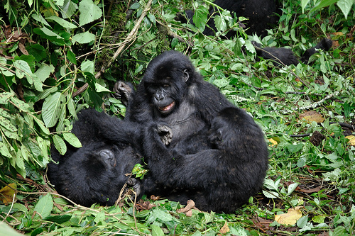
Kahuzi-Biéga is one of Africa's most biodiverse sites, hosting 136 mammal species, including the flagship eastern lowland gorilla (estimated at 250 individuals in habituated groups), eastern chimpanzees, bush elephants, bongos, giant forest hogs, aquatic civets, and 13 other primates like Angolan colobus and Hamlyn's monkeys. Rare species include the giant forest genet, Maclaud’s horseshoe bat, and Alexander’s bush squirrel. Flora comprises over 1,178 plant species across six vegetation types, from lowland rainforests to subalpine heather and giant groundsels (Dendrosenecio erici-rosenii), with endemic plants like Senecio kahuzicus in high-altitude bogs. Avifauna is exceptional, with 349 bird species, including 42 endemics such as the Congo peafowl, Ruwenzori turaco, African green broadbill, Rockefeller’s sunbird, and Shelley’s crimsonwing. The park's unbroken ecosystem gradient fosters this diversity, making it a key Endemic Bird Area and plant diversity center.
Conservation is managed by the Congolese Institute for
Nature Conservation (ICCN) in partnership with organizations like the
Wildlife Conservation Society (WCS), UNESCO, and others, focusing on
anti-poaching patrols, habitat monitoring, and community engagement.
Efforts include gorilla habituation, chimpanzee programs at Lwiro
Sanctuary, and closing illegal mines. A 2022 public-private partnership
with WCS aims to enhance protection, while GEF-funded projects address
deforestation and climate adaptation. Indigenous Batwa involvement is
emphasized for sustainable management.
Threats include armed
conflicts, with M23 rebels controlling areas since early 2025, leading
to expanding forest loss visible in satellite imagery. Poaching for
bushmeat, illegal mining for coltan and gold, habitat conversion, and
militias (e.g., FDLR remnants) have decimated populations—gorillas
dropped from thousands to about 3,800 regionally by 2016. Batwa
evictions have fueled tensions, with violence against them by guards,
and corruption among officials exacerbates issues. As of 2025, the
park's endangered status persists, with 90% inaccessible to staff, and
challenges like understaffing, economic instability, and climate-induced
ecosystem stress hinder progress.
Activities center on eastern lowland gorilla trekking
(USD 400 permit, 4–6 hours, limited to eight visitors per group),
chimpanzee habituation at Lwiro (USD 40), birdwatching, hiking Mount
Kahuzi or Biega (USD 100), waterfall visits (USD 25), cultural tours
with Batwa communities, and Lake Kivu boat cruises (USD 50). Camping
safaris (USD 50/day) and nature walks are available, with best times in
dry seasons (June–September, December–February) for trails or wet
seasons for birding. Access requires a 4x4 vehicle; from Kigali (5–7
hours drive) or flights to Goma/Kavumu, then road to Bukavu (30 km, 1.5
hours). Permits must be booked in advance; accommodations include
mid-range hotels like Orchids Safari Club. Security is monitored, but
visitors should check advisories due to instability—self-drives are
discouraged.
The park's significance lies in protecting the last
major population of eastern lowland gorillas and one of the Albertine
Rift's richest sites for endemics, contributing to global biodiversity
amid DRC's conflicts. It exemplifies "fortress conservation" debates,
with potential for indigenous-led models post-2024 rulings, and supports
eco-tourism for local economies while highlighting resilience in
Africa's wilderness.