Location: Map
Area: 10,830 km²
Official site
Virunga National Park (Parc National des Virunga), located in the eastern Democratic Republic of the Congo (DRC), is Africa's oldest national park and one of the most biodiverse protected areas on the continent. Established in 1925, it spans approximately 3,000 square miles (7,800 square kilometers) and is renowned for its stunning landscapes, active volcanoes, and critical role in conserving endangered species like mountain gorillas. As a UNESCO World Heritage Site since 1979, it encompasses a remarkable range of habitats that surpass those of any other African park, making it a global treasure for biodiversity and natural wonders.
Current Status (as of June 2026)
Gorilla treks and Nyiragongo
Volcano treks are closed until further notice, according to the official
Visit Virunga site. Contact visit@virunga.org for updates or bookings.
The park may offer limited activities or packages at times (e.g., via
lodges like Mikeno), but major attractions can close suddenly for
security reasons. Always verify the latest via the official site
(visit.virunga.org or virunga.org) and your government's travel
advisories (e.g., US State Department often rates eastern DRC as "Do Not
Travel").
The park prioritizes visitor safety with armed ranger
escorts, but risks from armed groups persist. Many travelers choose
Uganda or Rwanda for gorilla trekking instead, which are generally more
stable.
Safety Considerations
Virunga has a reputation as one
of Africa's more dangerous parks due to armed groups, poaching, and past
incidents (e.g., ranger deaths, occasional tourist kidnappings leading
to closures).
Park-managed visits provide convoys, armed rangers
(often 2–10+ per group), and strict protocols. Tourism is concentrated
in the southern sector (gorillas/volcano).
Independent travel or
wandering outside designated areas is strongly discouraged.
Check
real-time advisories; the park may close attractions and refund bookings
if risks rise.
Comprehensive travel insurance (including
high-coverage medical evacuation) is mandatory.
Ebola and other
health outbreaks have occurred; follow updates.
Recommendation: Only
experienced, risk-tolerant travelers should consider it, ideally via
official packages. Many sources suggest Uganda/Rwanda as safer
alternatives for similar experiences.
Best Time to Visit
Dry
seasons (June–September and December–February) are preferred for
trekking: less mud, better trails, and visibility. June–September is
ideal for Nyiragongo's lava lake viewing.
Rainy seasons (March–May,
October–November) bring slippery paths, but fewer crowds and sometimes
discounted permits. Gorillas may be easier to locate as they stay
closer.
Weather: Daytime ~24°C (75°F) at lower elevations; cooler at
altitude/nights. Prepare for rain year-round.
How to Get There
Most visitors fly into Kigali, Rwanda (KGL), then travel by road to the
Grande Barrière border crossing (Gisenyi/Goma). Direct flights to Goma
(GOM) are possible but limited.
Border crossing: Virunga staff assist
at the tourism office in the border building. Present booking
confirmation for visa facilitation. Yellow fever certificate required.
Visa: DRC tourist visa needed. Book a Virunga package first for a
special single-entry visa (~$105, processed via their system).
Processing takes time; apply in advance or at border in some cases.
Transfers: Included in official packages (Goma to park ~1.5 hours).
Private transport from Kigali or Goma available but use trusted
operators.
Internal: Park handles all transport in convoys for
safety.
Main Attractions and Activities (When Open)
Mountain
Gorilla Trekking: Habituation allows close encounters (1-hour visit).
Permits ~$400 (cheaper than Rwanda/Uganda); groups limited (4–6 people).
Hikes 1–2.5+ hours one way through steep, dense terrain.
Nyiragongo
Volcano Trek: Hike to summit (~3,470m / 11,380 ft) for the world's
largest lava lake. 4–6 hours up, overnight in crater rim shelters (cold,
basic). Porters available.
Other: Chimp habituation, Senkwekwe
gorilla orphanage, birding, nature trails, savanna safaris in central
sector (Ishasha Plains), Mikeno forest walks, Congohounds (anti-poaching
dogs).
Gorilla Trek Rules (standard): No flash photography, maintain
~7–10m distance, no eating/drinking near gorillas, follow ranger
instructions, masks sometimes required for health.
Accommodations
Virunga operates its own lodges (no independent camping):
Mikeno
Lodge (near Rumangabo, gorilla area): Luxurious bungalows with
fireplaces, en-suite baths, restaurant, views. Prime for
gorillas/chimps. WiFi available.
Kibumba Tented Camp: Newer, tented
option near gorilla trekking start.
Tchegera Tented Camp: On an
island in Lake Kivu, more relaxed.
Packages include full board
(except volcano), laundry, etc. Book via visit.virunga.org.
In-Depth Visiting Tips
Book Officially: Use visit.virunga.org for
packages (e.g., Virunga Classic: multiple nights, treks, transport, visa
support). This ensures security and logistics.
Health Preparations:
Vaccines: Yellow fever (mandatory, with card, 10+ days prior). Routine +
hepatitis, typhoid, rabies (consider), COVID per rules.
Malaria:
Prophylaxis recommended.
Bring medications, first aid, insect
repellent (DEET), hand sanitizer.
Altitude: Acclimatize for volcano;
fitness essential for treks (steep, muddy).
What to Pack:
Clothing: Long sleeves/pants (insect/sun protection), waterproof hiking
boots (broken in), rain jacket/poncho, warm layers/fleece (nights/cold
summit), hat, gloves.
Gear: Daypack, binoculars, camera (no flash),
headlamp, sturdy walking poles, reusable water bottle.
Volcano-specific: Warm sleeping bag/layers (down to freezing), poncho.
Cash: Crisp USD (post-2009, undamaged) for tips/extras; cards for
bookings.
Other: Sunscreen, toiletries, donations for
community/rangers (e.g., school supplies, balls).
Fitness and
Expectations: Treks are strenuous. Gorillas are habituated but wild—be
respectful. Hikes can be longer than expected.
Cultural/Community:
Support local initiatives (e.g., Widows' Workshop). Tipping
~$10/person/day suggested via tip box. Learn basic French/Swahili
phrases.
Photography: Respect rules; gorillas sensitive to flashes.
Sustainability: Your visit funds conservation and rangers. Follow
leave-no-trace.
Logistics: Arrive at border by ~11am for packages.
SIM card for local service. Filtered water at lodges (except volcano).
Location and Boundaries
The park sits in the Congo-Nile watershed
in North Kivu Province, stretching approximately 300 km (190 mi) from
north to south along the DRC's borders with Uganda (to the northeast and
east) and Rwanda (to the southeast). Its coordinates are centered around
0°55′S 29°10′E (with the full park spanning roughly 0°23′S 29°30′E). To
the south, it reaches the northern shore of Lake Kivu near Goma; to the
north, it is bounded by the Puemba River. It adjoins Uganda's Rwenzori
Mountains National Park and Semuliki National Park in the north, and
forms part of the Greater Virunga Transboundary Collaboration with
Rwanda's Volcanoes National Park and Uganda's Mgahinga Gorilla National
Park in the south.
Size and Administrative Sectors
Virunga
covers 7,800 km² (790,000 ha or about 3,000 sq mi)—roughly the size of
three Luxembourgs or the U.S. state of Delaware. It is divided into four
main sectors (Northern, Central, Southern, and Lake) for management,
each showcasing distinct landscapes:
Northern Sector: Dominated
by the Rwenzori Mountains and Semliki River valley.
Central Sector:
Features Lake Edward, the Ishasha River valley, and the Rwindi plains.
Southern Sector: Encompasses the Virunga Massif volcanoes and montane
forests.
Lake Sector: Includes much of Lake Edward itself.
Topography and Major Landforms
The park's topography is dramatically
varied due to its position in the rift valley. Elevations range from a
low of 680 m (2,230 ft) in the Semliki River valley lowlands to a high
of 5,109 m (16,762 ft) at Margherita Peak (Mount Stanley) in the
Rwenzori Mountains—the third-highest peak in Africa and the highest in
the DRC. This extreme gradient (over 4,400 m within a short horizontal
distance in places) creates one of the world's most compressed
ecological transitions.
Northern Sector (Rwenzori Mountains):
Often called the "Mountains of the Moon," these ancient, eroded block
mountains (not volcanic) feature sharp peaks, deep valleys, and
equatorial glaciers/snowfields—the only true alpine chain in Africa with
permanent ice on the equator. The park includes about 20% of the
Rwenzori massif.
Central Sector: Lowland plains, valleys, and
savannas around Lake Edward, with rolling grasslands (e.g.,
Rwindi-Rutshuru plains) and wetlands.
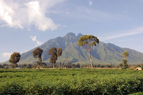
Southern Sector (Virunga
Massif): A chain of eight volcanoes (seven mostly or fully in the park),
rising steeply from the rift floor. Peaks include dormant Mount Mikeno
(4,437 m / 14,557 ft) and others like Karisimbi, Visoke, and Sabinyo.
Geology and Volcanic Activity
Virunga lies at the heart of the
tectonically active Albertine Rift, where the African Plate is
splitting. The southern Virunga volcanoes are the most striking feature:
Nyiragongo (3,470 m / 11,380 ft) and Nyamuragira (3,058–3,063 m /
~10,000 ft) are two of Africa's most active volcanoes, together
accounting for about 40% of the continent's recent eruptions. Nyiragongo
is a stratovolcano famous for its persistent lava lake (one of the
world's largest and most fluid, with highly alkaline lava) and frequent
flank eruptions that create vast lava fields and new habitats.
Nyamuragira is a shield volcano with more effusive flows. Lava plains,
recent flows, and thermal features (like Mai ya Moto sulfur springs and
hot springs) dominate the southern landscape. In contrast, the Rwenzori
Mountains result from older tectonic uplift rather than volcanism.
Hydrology
The park is hydrologically significant, feeding both
the Congo and Nile basins. Key features include:
Lake Edward (one
of the African Great Lakes): The Central Sector encompasses much of its
western and southern shores (144,548 ha of the lake within the park), a
fertile body teeming with aquatic life and fringed by hippo herds and
wetlands.
Rivers: The Semliki River (northern lowlands, flowing to
Lake Albert); Ishasha River (central boundary with Uganda); Rutshuru
River; and Puemba River (northern boundary). The Molindi spring and
underground flows through lava fields contribute significantly to river
recharge.
Other features: Rutshuru Falls, swamps, marshes at lava
flow ends, ponds (e.g., Lake Ondo, Kibuga pond), and sulfur springs.
Climate
Climate is highly variable due to altitude, aspect, and
the Intertropical Convergence Zone. It features bimodal rainfall (main
rainy seasons: March–mid-May and September–November). The driest areas
around Lake Edward receive only ~500 mm (20 in) annually, while western
Rwenzori slopes can exceed 3,000 mm (118 in). Temperatures drop with
elevation: 23–28°C (73–82°F) in lowlands to 16–24°C (61–75°F) at higher
altitudes (rarely below 14°C / 57°F). The park experiences both the
country's highest and lowest rainfall extremes within its borders.
Resulting Ecosystems and Geographical Diversity
This combination
of rift tectonics, extreme elevation range (680–5,109 m), and equatorial
location at the crossroads of Guinea-Congolian, afro-montane, and
Central African lake biogeographic regions produces unmatched habitat
variety: savannas and steppes, acacia woodlands, lowland and montane
forests (including bamboo), afro-alpine meadows with giant lobelias and
senecios, lava fields in various successional stages, swamps, peat bogs,
and even equatorial glaciers. The park's geography directly supports its
status as a UNESCO World Heritage Site for its outstanding universal
value in natural habitats and biodiversity.
Virunga National Park (Parc National des Virunga), located in the
eastern Democratic Republic of the Congo (DRC) within the Albertine Rift
Valley, is Africa’s oldest national park and one of the world’s most
biologically diverse protected areas. Spanning approximately 7,800 km²
(790,000 hectares), it stretches from the Virunga Mountains in the south
(bordering Rwanda’s Volcanoes National Park and Uganda’s Mgahinga
Gorilla National Park) northward through savannas, wetlands, and the
Rwenzori Mountains (“Mountains of the Moon”) to Lake Edward and the
Semliki River valley. Its dramatic landscapes include active volcanoes
like Nyiragongo and Nyamuragira, Afro-alpine zones, grasslands, forests,
and lava fields—supporting over 3,000 species, including roughly half of
the world’s critically endangered mountain gorillas (Gorilla beringei
beringei), chimpanzees, okapi, the continent’s largest hippopotamus
population, golden monkeys, and hundreds of endemic birds, reptiles, and
plants.
The park’s history is inextricably linked to European
colonialism, scientific exploration, international conservation
movements, post-independence Congolese sovereignty, devastating regional
conflicts, and innovative modern efforts to balance biodiversity
protection with community development. It celebrated its centenary in
April 2025, marking 100 years as a symbol of both resilience and ongoing
struggle.
Pre-Colonial Context and Indigenous Presence
Before
European colonization, the Virunga region had been inhabited for over a
millennium by diverse ethnic groups, including Banyarwanda (Hutu and
Tutsi), Nande, Hema, and especially Batwa (also known as Bambuti or
Mbuti Pygmies), who were hunter-gatherers with deep traditional
knowledge of the forests. These communities relied on the land for
hunting, gathering, fishing, and cultural practices. The area’s rich
resources—wood, arable land, wildlife, and minerals—sustained local
livelihoods long before formal protection.
Establishment as
Albert National Park (1925)
In the early 1920s, European
conservationists—including Belgian zoologist Victor van Straelen,
botanist Jean Massart, and explorer Jean-Marie Derscheid—advocated for a
protected area in the northeastern Belgian Congo, inspired by the global
conservation movement and figures like American naturalist Carl Akeley
(who had highlighted mountain gorilla threats). King Albert I of
Belgium, influenced by his visits to U.S. national parks, issued a royal
decree on April 21, 1925, creating Albert National Park (Parc National
Albert)—Africa’s first national park, predating South Africa’s Kruger by
about a year.
Initially covering just ~500 km² (about 10,000–25,000
hectares) around the extinct volcanoes Mount Karisimbi, Mikeno, and
Visoke in the Virunga Massif, it was conceived as a science-oriented
“natural laboratory” and strict nature reserve. The primary goal was to
protect mountain gorillas (then facing hunting pressure) while studying
wildlife, volcanic activity, and “primitive” hunter-gatherer Pygmy
communities, whom some Europeans romanticized as part of an untouched
Eden. It was modeled partly on Switzerland’s strict reserves, with
administration reporting directly to Brussels (independent of local
colonial authorities) and oversight by an international scientific
commission. Indigenous land rights were revoked early on, setting a
precedent for evictions.
In 1926, Derscheid led the first mapping
mission. The park expanded dramatically in 1929 (adding the broader
Virunga Mountains, Rutshuru Territory, and plains south of Lake Edward)
and further in the 1930s, reaching ~856,790 hectares by the early 1930s.
This included the Rwindi plains, Lake Edward, and parts of the Rwenzori
range. The Institut des Parcs Nationaux du Congo Belge was founded in
1934 to manage it.
Colonial Era: Scientific Expeditions, Tourism,
and Displacement (1930s–1960)
During Belgian rule, the park hosted
major scientific expeditions (e.g., led by Gaston-François de Witte in
the 1930s–1950s), collecting specimens for Belgian museums, studying
ethnic groups, fossils, and volcanoes. Limited tourism emerged, focused
on gorillas and landscapes, but infrastructure prioritized researchers.
However, expansion came at a cost: thousands of local people, especially
Rwandophone communities (an estimated 85,000 between the late 1930s and
1955), were forcibly relocated to areas like Masisi in North Kivu. Batwa
groups faced restrictions on traditional access, though some were
tolerated as “part of the pristine ecosystem.” Habitat degradation from
Tutsi herders’ cattle also threatened gorillas by the late 1950s.
Independence, Renaming, and Early Challenges (1960–1980s)
The DRC
gained independence in 1960 (as the Republic of the Congo), ushering in
major changes. Land reforms asserted state ownership, but weak
enforcement led to increased illegal hunting and poaching. In 1969,
under President Mobutu Sese Seko’s “Africanization” campaign, the park
(merging the original Albert and extended Virunga sectors) was renamed
Virunga National Park. Despite this, international influence persisted.
Virunga was inscribed as a UNESCO World Heritage Site in 1979 for its
outstanding universal value—geological features (active volcanoes),
habitats, and biodiversity (criteria vii, viii, x). It was also
designated a Ramsar wetland of international importance in 1996.
Mountain gorilla conservation gained global attention through research
and anti-poaching efforts.
Conflicts, Collapse, and Crisis
(1990s–2000s)
The 1990s brought catastrophe. The 1994 Rwandan
genocide displaced nearly 1 million refugees into the Kivus, with up to
40,000 entering the park daily for resources, causing massive
deforestation and poaching. Hippopotamus numbers plummeted from ~29,000
to fewer than 1,000 in Lake Edward. The First Congo War (1996–1997) and
Second Congo War (1998–2003) turned the park into a battleground
involving multiple armies and rebel groups (e.g., FDLR, Mai-Mai). Armed
militias controlled sectors, using the wilderness for smuggling
(charcoal, minerals like coltan and gold), looting, and hiding. Between
1996 and 2003, at least 80 park staff were killed; overall, more than
175 rangers have died in the line of duty since the conflicts began.
Virunga was added to the UNESCO List of World Heritage in Danger in 1994
(and remains there due to ongoing threats). A notorious 2007 gorilla
massacre in the Rugendo family (including silverback Senkekwe)
highlighted charcoal-linked poaching and rebel activity.
Modern
Era: Partnership, Innovation, and Resilience (2008–Present)
In 2008,
the Congolese Institute for the Conservation of Nature (ICCN) signed a
public-private management agreement with the Virunga Foundation
(formerly Africa Conservation Fund; later supported by the European
Commission). Belgian Prince Emmanuel de Merode became chief warden,
introducing paramilitary-style ranger training, anti-poaching
operations, and the Virunga Alliance—an integrated development program
addressing root causes of conflict like poverty through community
benefits (e.g., jobs, electricity). Three hydroelectric plants built in
the 2010s now power over 200,000 people and have created thousands of
jobs, reducing illegal charcoal production (previously ~$28–30 million
annually from the park).
Conservation gains include recovering
gorilla and hippo populations, though tourism has been suspended at
times due to insecurity (e.g., 2018–2019 after ranger and tourist
incidents). Oil exploration threats persist: a 2010 concession to Soco
International was halted after global outcry, but 2022 government
auctions of overlapping blocks drew renewed criticism.
Recent
challenges include M23 rebel advances (controlling parts of North Kivu
since the 2020s), continued FDLR/ADF activity, charcoal smuggling, and
clashes over land. Rangers face ambushes (e.g., multiple deaths in
2017–2021, including a 2021 incident killing an Italian ambassador). Yet
the park endures as a model of “militarized conservation” intertwined
with socioeconomic development, with 750 rangers today (up from 49 in
1938).
Flora: Diverse Vegetation Zones
Virunga hosts over 2,000–2,077
plant species, including 264 tree species and around 230 plants endemic
to the Albertine Rift (about 10% endemism). Vegetation changes
dramatically with altitude, creating distinct zones.
Lowland and
Riverine Forests / Tropical Rainforests (northern and lower sectors):
Dense equatorial and primary tropical forests with tall evergreen trees,
lianas, epiphytes, ferns, mosses, and orchids. These cover significant
areas and support high biomass. Common elements include giant trees
forming closed canopies.
Montane and Submontane Forests
(mid-altitudes, especially southern Virunga Massif): Rich in
biodiversity with mixed forests. Key species include Hagenia abyssinica
and Hypericum in higher montane zones.
Bamboo Forests: Extensive
stands of Arundinaria alpina, vital for mountain gorillas (a major food
source) and other wildlife.
Alpine and Subalpine Zones (high
altitudes, including Rwenzori influences): Afro-alpine vegetation with
giant senecios (Dendrosenecio), giant lobelias, heather (Erica), and
moorlands. These are adapted to extreme conditions and include many
endemics.
Savannas, Grasslands, and Wetlands: Plains dominated by
grasses (Sporobolus), papyrus (Cyperus papyrus), reeds, and acacia/thorn
species. Lava fields from volcanic activity host unique pioneer
vegetation. Wetlands and riverine areas around Lake Edward add aquatic
plants like ambatch.
The park's flora plays critical ecological
roles: seed dispersal by elephants, habitat for pollinators, and carbon
storage. Many species are threatened by deforestation, agriculture
encroachment, and climate change.
Fauna: Exceptional Mammal,
Bird, and Other Diversity
Virunga supports over 3,000 faunal and
floral species overall, with high endemism. It is particularly famous
for primates but boasts one of the highest wildlife biomass densities in
Africa (historically up to 27–314 tons/km² in savannas).
Mammals
(around 196–218 species)
Primates (22+ species): Iconic mountain
gorillas (Gorilla beringei beringei) — about one-third of the world's
population (hundreds in the Virunga Massif). Also eastern lowland
(Grauer's) gorillas, eastern chimpanzees, golden monkeys (Cercopithecus
kandti, endemic), blue monkeys, red-tailed monkeys, and others.
Large
Herbivores: Forest and savanna elephants, hippopotamuses (historically
one of Africa's largest populations along Lake Edward), buffalo, okapi
(DRC endemic), various antelopes and duikers (including rare red forest
duiker), giraffes in some areas.
Carnivores: Lions (in savanna
sectors), leopards, spotted hyenas, and smaller predators.
Other
Notable: Bongos, bushpigs, and a rich bat and rodent diversity.
Birds (706 species)
One of the highest avian diversities in Africa,
exceeding the total in the United States. Includes Albertine Rift
endemics, raptors (eagles), turacos, hornbills, waterbirds around Lake
Edward, and migratory Palearctic species. The park is vital for
wintering birds.
Reptiles and Amphibians
Reptiles: 109 species
— the richest in African protected areas. Includes crocodiles, snakes,
lizards, and chameleons.
Amphibians: 78+ species, with high endemism
in the Albertine Rift; many frogs and toads tied to wetlands and
forests.
Aquatic Life
Lake Edward and rivers support fish,
hippos, and crocodiles, contributing to the park's wetland biodiversity.