Location: Oudtshoorn, Western Cape Province Map
Length: 3.3 mi (5.3 km)
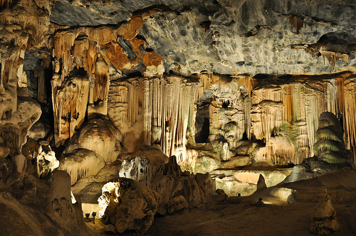
The Cango Caves, located near Oudtshoorn in South Africa’s Western Cape Province, are one of the world’s most spectacular limestone cave systems, renowned for their vast chambers, intricate stalactite and stalagmite formations, and historical significance. Nestled in the foothills of the Swartberg Mountains, the caves stretch over 5.3 kilometers, though only a portion is accessible to the public. Formed over millions of years, they are a geological marvel and a major tourist attraction, drawing visitors for their natural beauty and cultural history.
The Cango Caves are situated in the Precambrian limestone belt of the
Swartberg Mountains, formed approximately 800 million years ago. The
caves themselves began developing around 20 million years ago during the
Miocene epoch, through a process of chemical erosion:
Limestone
Dissolution: Rainwater, slightly acidic from dissolved carbon dioxide,
percolated through cracks in the limestone, dissolving calcium carbonate
and carving out underground chambers and passages over millennia.
Speleothem Formation: As water dripped into the caves, it deposited
calcium carbonate, creating stalactites (hanging from the ceiling),
stalagmites (rising from the floor), columns (where stalactites and
stalagmites meet), flowstones, and helictites (delicate, twisting
formations). These formations grow at a rate of about 1 cm per 100
years.
Cave Structure: The system comprises a series of
interconnected chambers, with the largest, Van Zyl’s Hall, measuring 107
meters long, 54 meters wide, and up to 18 meters high. The caves extend
5.3 km, with an explored depth of 300 meters, though ongoing surveys
suggest further undiscovered passages.
The caves maintain a stable
temperature of around 18–20°C and high humidity (90–95%), preserving the
delicate formations. The limestone is part of the Cango Formation, rich
in fossils like brachiopods and trilobites, offering clues to ancient
marine environments.
The accessible portion of the Cango Caves, known as Cango 1, spans
about 1.2 km and includes several iconic chambers:
Van Zyl’s
Hall: The grand entrance chamber, named after an early explorer,
features massive stalagmites like the “Cleopatra’s Needle,” a
9-meter-tall formation estimated to be 150,000 years old.
Botha’s
Hall: Known for its towering columns and the “Organ Pipes,” a series of
slender stalactites resembling organ pipes.
Rainbow Chamber: Noted
for its colorful flowstones, with hues of red, orange, and yellow from
iron and manganese oxides.
Drum Room: Named for the acoustic effect
of dripping water, this chamber contains the “Drum,” a large stalagmite.
Crystal Palace: A delicate chamber with intricate helictites and
curtain-like flowstones, showcasing the caves’ most fragile formations.
Devil’s Workshop: A narrow passage with grotesque, twisted formations,
adding a dramatic flair to tours.
Beyond Cango 1, Cango 2 and 3 are
wild, undeveloped sections reserved for scientific research and
experienced cavers due to their narrow passages and unstable conditions.
The Cango Caves have a rich history spanning prehistoric use,
colonial exploration, and modern tourism:
Prehistoric Use:
Archaeological evidence, including San rock art and tools found near the
cave entrance, suggests the caves were used as a shelter by San
(Bushman) people as early as 10,000 years ago. The San likely revered
the caves as spiritual sites, though they did not venture deep inside.
Colonial Discovery: The caves were first documented in 1780 by a farmer,
Jacobus van Zyl, who was lowered into the entrance by his servant. Early
explorers like Ensign Andries Schoon marked their visits with graffiti,
some still visible.
19th Century Exploration: The caves gained fame
as explorers mapped deeper chambers. By the 1800s, they were a curiosity
for European settlers, with crude tours involving candles and dynamite,
which damaged some formations.
Modern Tourism: The caves were
declared a National Monument in 1938 and opened to the public with
guided tours. Infrastructure like walkways, lighting, and handrails was
added in the 1960s, balancing accessibility with preservation.
Cultural Role: The caves feature in local folklore, with stories of
hidden treasures and mythical creatures like the “Cango Ghost.” They
also inspired Afrikaans literature and music, cementing their place in
South African heritage.
While the Cango Caves are not a biodiversity hotspot like surface
ecosystems, they support a unique troglodytic (cave-dwelling) ecosystem:
Microorganisms: Bacteria and fungi thrive in the humid environment,
contributing to limestone dissolution and speleothem growth. Some
microbes are studied for their potential in biotechnology.
Invertebrates: Cave crickets, spiders (Selenops spp.), and
pseudoscorpions inhabit darker recesses. These species are adapted to
low light and scarce food, relying on organic debris brought by water or
bats.
Bats: Small populations of horseshoe bats (Rhinolophus spp.)
and Schreiber’s long-fingered bats (Miniopterus schreibersii) roost in
quieter sections, though numbers are low due to human disturbance.
Introduced Species: Human activity has introduced non-native insects
like cockroaches, which can disrupt the delicate ecosystem.
The
caves’ ecological balance is fragile, with human breath, touch, and
lighting potentially fostering algae growth or altering humidity. Strict
conservation measures minimize these impacts.
The Cango Caves are a top attraction in South Africa’s Garden Route,
offering guided tours that cater to different interests and fitness
levels.
Tour Options
Heritage Tour: A 60-minute, 1.2-km walk
through Cango 1, suitable for all ages (children under 5 free). This
tour covers six major chambers, with easy walkways, stairs (about 200
steps), and informative guides explaining geology and history.
Highlights include Cleopatra’s Needle and the Crystal Palace. Tours run
hourly from 9 AM to 4 PM.
Adventure Tour: A 90-minute, physically
demanding tour for those over 6 years old, covering tighter passages and
requiring crawling, climbing, and squeezing through narrow gaps (e.g.,
the “Devil’s Chimney,” 27 cm wide). This tour offers a thrilling
exploration of less accessible areas but is not recommended for
claustrophobic, pregnant, or unfit visitors. Tours depart every 1–2
hours, with smaller groups (max 10).
Photography Tours: Specialized
tours for photographers, available by booking, allow tripods and
extended time in chambers for capturing formations under controlled
lighting. These are pricier and limited to small groups.
Key
Features
Lighting: Subtle electric lighting highlights formations
without promoting algae growth. Colors are natural, with no artificial
tinting.
Accessibility: The Heritage Tour is wheelchair-accessible in
parts of Van Zyl’s Hall, but stairs limit full access. The Adventure
Tour is not accessible for mobility-impaired visitors.
Guides:
Knowledgeable guides, trained by the Cango Caves management, share
geological, historical, and ecological insights, often in English or
Afrikaans. Private guides can be arranged for other languages.
Visitor Center: Located at the entrance, it offers exhibits on cave
formation, fossils, and San history, plus a gift shop and restaurant
serving light meals.
Location: 29 km north of Oudtshoorn, a 30-minute drive via the R328.
The caves are 120 km from George (1.5 hours) and 400 km from Cape Town
(5 hours).
Entrance Fees: Heritage Tour: ~ZAR 220 (adults), ~ZAR 120
(children 6–12). Adventure Tour: ~ZAR 300 (adults), ~ZAR 180 (children
6–12). Prices as of 2025; discounts available for groups or online
bookings.
Hours: Open daily 9 AM–5 PM, except Christmas Day. Last
tours depart at 4 PM.
Booking: Reservations are recommended,
especially for Adventure and Photography Tours, via the official Cango
Caves website or by phone. Peak seasons (December–January, July–August)
require advance booking.
Facilities: Ample parking, restrooms, a
picnic area, and a curio shop. Nearby Oudtshoorn offers hotels,
guesthouses, and attractions like ostrich farms.
Restrictions: No
food, drinks, or touching formations. Photography is allowed (no flash
on standard tours), but tripods require a Photography Tour. Adventure
Tour participants must be at least 1.2 m tall and under 120 kg.
Best Time to Visit
The caves are a year-round destination due to
their stable climate, but:
Spring (September–November) and Autumn
(March–May): Mild weather (15–25°C) makes for comfortable travel to
Oudtshoorn.
Summer (December–February): Busy with local tourists;
book early. Temperatures can hit 30°C outside, but the caves remain
cool.
Winter (June–August): Quieter, with cooler surface temperatures
(10–20°C), ideal for combining with other Garden Route attractions.
Early morning tours are less crowded, offering a more intimate
experience.
The Cango Caves face several threats, managed through strict
protocols:
Human Impact: Touching formations transfers oils that
halt growth, while exhaled CO₂ can alter cave chemistry. Walkways and
no-touch rules mitigate this.
Lighting and Algae: Early overuse of
bright lights caused algae growth, damaging formations. Modern low-UV
lighting minimizes this risk.
Tourism Pressure: High visitor numbers
(over 200,000 annually) strain infrastructure and disturb bats. Caps on
tour sizes and restricted access to Cango 2 and 3 protect the ecosystem.
Climate Change: Changes in rainfall could affect water seepage, slowing
speleothem growth. Monitoring systems track humidity and CO₂ levels.
Vandalism: Historical graffiti and dynamite use caused irreversible
damage. Security and guided access prevent further harm.
The caves
are managed by the Oudtshoorn Municipality, with input from
speleological experts and the South African Heritage Resources Agency.
Research in Cango 2 and 3 focuses on paleoclimatology, using stalagmite
rings to study ancient climate patterns.
Cultural Role: The caves are a symbol of South Africa’s natural
heritage, featured in tourism campaigns and local lore. They also serve
as an educational site, teaching visitors about geology and
conservation.
Scientific Value: The caves offer insights into Miocene
geology, with fossils and speleothems providing data on past climates
and marine life. Ongoing studies explore microbial life for potential
medical applications.
Conservation Model: The caves’ management
balances tourism with preservation, serving as a case study for other
karst systems globally.