Location: Meroe Map
Date: 260 BC to 350 AD
Height: 98 feet (30 m)
When: Oct- Mar
Entry: $9
Temp: Jan 90F (32 C)
Apr 100F (38 C)
Oct 104F (40 C)
Meroë, located on the east bank of the Nile River in present-day Sudan, approximately 200 km northeast of Khartoum, was the capital of the Kingdom of Kush from around 590 BCE to 350 CE. Known for its more than 200 Nubian pyramids, vibrant trade networks, and unique blend of African, Egyptian, and Greco-Roman influences, Meroë was a wealthy metropolis and a major center of power in the ancient world. As part of the UNESCO World Heritage Site “Archaeological Sites of the Island of Meroe,” which includes the nearby sites of Naqa and Musawwarat es-Sufra, it represents a critical chapter in African history.
Meroë is situated in the semi-desert region of Butana, historically
referred to as the “Island of Meroe,” a fertile area bounded by the Nile
River (from the Atbarah River to Khartoum), the Atbarah, and the Blue
Nile. The city lies 6 km northeast of Kabushiya near the modern village
of Bagrawiyah, covering approximately 10 km². Its strategic location
offered:
Fertile Land: Positioned on the fringe of the summer
rainfall belt, Meroë benefited from seasonal flooding and fertile soils,
supporting agriculture and cattle herding.
Trade Routes: The city was
a crossroads for trade between sub-Saharan Africa, Egypt, the Red Sea,
and beyond, facilitating commerce in gold, ivory, iron, and exotic
goods.
Natural Resources: Rich deposits of iron ore and hardwood
forests fueled a robust ironworking industry, earning Meroë the nickname
“Birmingham of Africa.”
The landscape features reddish-brown hills
and seasonal rivers that made Meroë a “seasonal island” during floods.
Large circular reservoirs (hafirs) collected water for agriculture and
livestock, critical in the arid environment.
Meroë’s geology is shaped by the Nile Valley’s sedimentary deposits
and surrounding sandstone hills. The region’s iron-rich soils and
proximity to mines supported industrial activities.
Flora
Savanna Vegetation: The semi-desert supports acacia trees (Acacia
seyal), grasses, and shrubs adapted to seasonal rains. Arid zones
feature sparse Balanites aegyptiaca (desert date).
Agricultural
Crops: Sorghum, millet, and barley were cultivated, with evidence of
date palms and fruit trees near settlements.
Deforestation: Iron
smelting consumed forests for charcoal, contributing to erosion and
environmental degradation by the 4th century CE.
Fauna
Wildlife: The region historically supported elephants, lions, and
antelopes, hunted for ivory and hides. Cattle were central to the
economy, with hafirs built to sustain herds.
Birds: Migratory birds,
such as storks and herons, frequented the Nile and wetlands. Vultures
and eagles inhabited the hills.
Domesticated Animals: Camels
(dromedaries) facilitated trade, while horses were used in warfare, as
evidenced by harnesses found in pyramids.
Overgrazing and
deforestation led to ecological stress, exacerbating Meroë’s decline.
Meroë was the heart of the Kingdom of Kush, a major African power
from the 8th century BCE to the 4th century CE. Its history reflects a
dynamic interplay of local innovation and external influences.
Origins and Rise
Early Settlement: Meroë was inhabited as early as
890 BCE, with the oldest tomb dating to this period. It served as an
administrative center under the Napatan Kingdom (c. 800–590 BCE), whose
capital was Napata, 400 km north.
Capital Shift: After Egyptian
Pharaoh Psamtik II sacked Napata in 591 BCE, King Aspelta moved the
capital to Meroë, likely for its distance from Egypt, fertile land, and
trade advantages.
Golden Age (c. 300 BCE–100 CE): Meroë flourished
under the Meroitic period, marked by economic prosperity, cultural
innovation, and independence from Egyptian dominance. King Ergamenes
(Arkamani I, c. 285 BCE) broke with Egyptian burial traditions,
establishing Meroë as the royal necropolis and fostering a distinct
Kushite identity.
Cultural Hybridity
Meroë’s culture blended
Nubian, Egyptian, and Hellenistic elements:
Religion: The Kushites
worshipped Egyptian gods like Amun (Amani) and Isis, alongside local
deities like Apedemak, a lion-headed war god. Temples to Apedemak at
Naqa and Musawwarat es-Sufra are iconic.
Language and Script: The
Meroitic script, developed in the 3rd century BCE, replaced Egyptian
hieroglyphs. With cursive and hieroglyphic forms, it remains partially
deciphered, limiting insights into Meroitic life.
Art and
Iconography: Meroitic art featured Egyptian-style reliefs with Nubian
elements, such as distinctive crowns, garments, and weapons. Kings and
queens were depicted subduing enemies, often with lions at their feet.
Political System: Unlike Egypt’s hereditary kingship, Meroë elected
rulers from royal kin, a process involving military leaders and priests,
as documented in inscriptions by kings like Aspelta and
Amani-nete-yerike. Queens (kandakes) like Amanitore wielded significant
power, sometimes leading armies.
Trade and Industry
Meroë was
a trade hub, exporting iron tools, gold, ivory, and textiles to Egypt,
Rome, Greece, India, and China. Its iron smelting industry was advanced,
producing weapons and tools that strengthened its military and economy.
The city’s location near the Red Sea and Nile facilitated commerce, with
archaeological finds like Roman glass and Indian pottery attesting to
its global reach.
Decline and Fall
Meroë declined by 300 CE
due to:
Environmental Degradation: Deforestation and overgrazing
eroded fertile land, undermining agriculture.
Economic Shifts: The
rise of Aksum (modern Ethiopia) diverted Red Sea trade, weakening
Meroë’s economy.
Aksumite Invasion: Around 330–350 CE, Aksumite king
Ezana likely sacked Meroë, as suggested by a stele found at the site.
Internal Instability: Political and economic decline reduced Meroë’s
ability to resist external pressures.
The city was abandoned by 350
CE, leaving its pyramids and ruins as enduring monuments.
Meroë’s architectural legacy, characterized by Nubian pyramids and
grand temples, reflects its wealth and cultural synthesis.
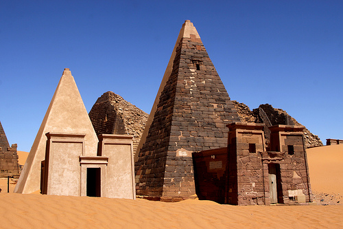
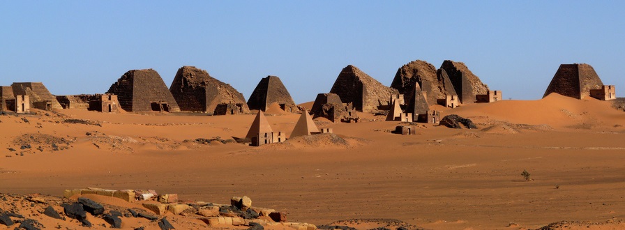
Nubian
Pyramids
Description: Over 200 pyramids in three cemeteries (West,
South, and North) served as royal tombs. Smaller than Egyptian pyramids
(6–30 meters high), they have steep slopes (up to 70°) due to
construction using a shaduf crane. Built from sandstone with rubble
cores, they lack internal burial chambers; instead, bodies were interred
in subterranean chambers.
Cemeteries:
South Cemetery: The
oldest, used from c. 800–300 BCE, with simpler structures.
North
Cemetery: Contains the best-preserved pyramids, including those of kings
like Adikhalamani (207–186 BCE).
West Cemetery: Includes queens’
burials, with some pyramids heavily damaged by 19th-century looters.
Decorations: Pyramid chapels feature reliefs of gods (Isis, Osiris) and
hieroglyphics. Offerings included bows, horse harnesses, and imported
goods. No royal remains have been found, likely due to ancient grave
robbing.
Damage: Italian treasure hunter Giuseppe Ferlini destroyed
many pyramid tops in the 1830s, seeking gold. Recent restorations, like
Pyramid 9’s burial chamber, aid preservation.
Royal City
Walled Compound: Enclosed palaces, a shrine to Nile floodwaters, and
administrative buildings, now largely ruined.
Temples: The Amun
Temple (in Napata, but linked to Meroë’s rulers) and local temples to
Apedemak, Isis, and the “Sun” showcased Meroitic art. The Lion Temple at
Naqa, with reliefs of rulers Natakamani and Amanitore, is a masterpiece.
Royal Bath: A ceremonial pool, possibly for rituals, reflects Egyptian
influence.
Industrial Areas: Iron smelting workshops and pottery
kilns supported the economy.
Nearby Sites
Naqa: 50 km east, a
religious and trade center with the Apedemak Lion Temple and a
Hellenistic-style kiosk, possibly a Hathor shrine.
Musawwarat
es-Sufra: 40 km south, known as Aborepe, features the Great Enclosure (a
complex of buildings and ramps) and a restored Lion Temple. These sites,
part of the UNESCO designation, highlight Meroë’s regional influence.
Meroë is a remote but rewarding destination, offering a glimpse into
an often-overlooked civilization.
Access
By Road: 200 km (3–4
hours) from Khartoum via a desert road to Bagrawiyah. 4x4 vehicles are
recommended for sandy tracks to the pyramids.
By Tour: Most visitors
join guided tours from Khartoum, arranged by operators like ITC Sudan,
which include Meroë, Naqa, and Musawwarat es-Sufra.
By Air: No direct
flights; Khartoum’s airport is the nearest hub.
Key Attractions
Pyramid Necropolis: The North Cemetery’s red-brick and sandstone
pyramids, set against desert dunes, are the highlight. Sunrise or sunset
visits enhance their photogenic quality.
Royal City Ruins: Low walls
require imagination, but guides provide context about palaces and
temples.
Naqa and Musawwarat es-Sufra: Day trips from Meroë (1–2
hours by 4x4) offer well-preserved temples and carvings. The Naqa Lion
Temple’s reliefs and Musawwarat’s elephant carvings are must-sees.
Cultural Experiences: Local vendors sell pyramid replicas, and camel
rides are available near the necropolis.
Entrance Fees: ~$20–30 USD for Meroë, Naqa, and Musawwarat, payable
at the site or through tour operators. Permits may be required for
photography.
Accommodations: Meroe Camp, a tented camp overlooking
the pyramids, offers basic but scenic lodging (~$50–100/night). Hotels
in Khartoum (e.g., Acropole Hotel) serve as bases.
Facilities:
Minimal; bring water, sunscreen, and food. Toilets are basic, and
there’s no visitor center. Guides are essential for historical context.
Best Time to Visit: November–March, with cooler temperatures (20–30°C).
Summer (April–October) is scorching (40°C+), and dust storms are
possible.
Safety: Sudan’s political instability and ongoing conflicts
(as of 2025) require caution. Check travel advisories and travel with
reputable operators.
Challenges
Tourism Infrastructure: Sudan
receives fewer than 15,000 tourists annually due to sanctions and
conflict, limiting amenities.
Preservation: Looting and erosion
threaten the site. The Qatari Mission for the Pyramids of Sudan (QMPS)
supports restoration, but funding is limited.
Language Barrier:
Meroitic script’s partial decipherment restricts understanding. Guides
rely on Egyptian, Greek, and Roman accounts, which may be biased.
Meroë faces significant threats:
Looting and Vandalism:
19th-century plunderers like Ferlini damaged pyramids, and ancient grave
robbing emptied tombs.
Environmental Erosion: Wind and sand erode
sandstone structures, while past deforestation weakened the region’s
sustainability.
Conflict: Sudan’s civil war (ongoing as of 2025)
disrupts tourism and conservation, with sites at risk from neglect or
collateral damage.
Underfunding: Limited resources hinder restoration
and research, despite UNESCO’s support.
Efforts by the QMPS, UNESCO,
and archaeologists like Charles Bonnet focus on pyramid restoration,
site protection, and community engagement. Local guides and tourism
provide economic incentives for preservation.
Archaeological Value: Excavations since 1902 have revealed palaces,
temples, and ironworks, with the Meroe Head of Augustus (a looted Roman
bronze buried under temple steps) highlighting Kushite resistance.
Cultural Legacy: Meroë’s hybrid culture challenges Egypt-centric
narratives, emphasizing African agency. Its Nubian pyramids and elected
rulers reflect a sophisticated society.
Global Connections: Trade
with Rome, India, and China underscores Meroë’s role in ancient
globalization.
Ongoing Research: Scholars like Theophile Obenga have
advanced Meroitic script studies, though full decipherment remains
elusive.