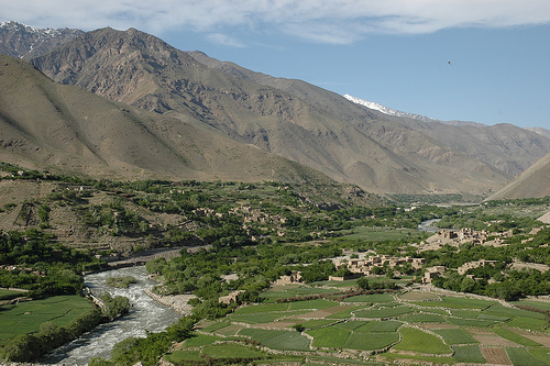
Location: 150 km North of Kabul Map
Another Map
Area: 3526 km2
Panjshir Valley (also spelled Panjshir or Panjsher, meaning
"Valley of the Five Lions" in Dari) is a narrow, fertile valley in
northeastern Afghanistan, about 150 km (93 mi) north of Kabul in the
Hindu Kush mountains. It stretches roughly 100 km along the Panjshir
River, which divides the valley, with high mountain ranges on either
side (Panjshir Range to the north and Kuhestan Range to the south).
Its strategic location includes key passes over the Hindu Kush—such
as the Khawak Pass (3,848 m) leading to Afghanistan’s northern
plains and the Anjuman Pass (4,430 m) into Badakhshan—making it a
historic highway for armies, traders, and invaders from Alexander
the Great to Timur.
The valley’s rugged terrain—narrow entrances,
steep cliffs, caves, and the fast-flowing river—has long made it a
natural fortress, difficult for conventional forces to control. It
is home to fertile agricultural land (supporting orchards, cherries,
and crops) and rich mineral resources, including emeralds, lapis
lazuli, aquamarine, turquoise, and historically silver. As of the
early 21st century, the population exceeds 100,000–330,000
(depending on province-wide figures), predominantly ethnic Tajiks
(about 97%), with smaller Hazara, Pashayi, and Ormuri communities.
It became its own province (Panjshir Province) in 2004, previously
part of Parwan, and is divided into seven districts (e.g., Bazarak,
the administrative center).
Location and Extent
The valley sits approximately 150 km (93 mi)
north of Kabul, centered around coordinates 35°16′N 69°28′E. It
stretches roughly 100–120 km in length (southwest to northeast) as a
long, linear gorge carved through the southern slopes of the central
Hindu Kush. The province itself covers 3,771 km², with the Panjshir
River watershed (a key sub-basin of the larger Kabul River system)
measuring about 3,447 km² in its core high-altitude catchment.
The province borders:
North: Baghlan and Takhar provinces
East:
Badakhshan and Nuristan provinces
South: Laghman and Kapisa provinces
West: Parwan Province
It is divided into seven districts (Anaba,
Bazarak—the capital, Darah, Khenj, Paryan, Rokha, and Shotul) containing
over 500 villages. The valley serves as a historic corridor, with two
major high passes linking it northward: the Khawak Pass (3,848 m /
12,625 ft) to the northern plains and the Anjuman Pass (4,430 m / 14,534
ft) into Badakhshan. These routes have been used since ancient times,
including by armies of Alexander the Great and Timur.
Topography
and Landforms
Panjshir Valley is a classic narrow, steep-sided
mountain gorge typical of the Hindu Kush, with the Panjshir River
bisecting it longitudinally. The valley floor is relatively confined,
flanked by towering ridges that rise dramatically—often 3,000 m (9,800
ft) or more above the valley bottom—creating an imposing natural
barrier.
Key topographic details include:
Elevation range:
Valley floor averages around 2,101 m (with sections from ~1,883 m to
2,759 m); surrounding province averages 3,486 m, ranging from 1,500 m
(lower valleys) to 5,671 m at the highest peaks.
Major ranges:
Panjshir Range to the north and Kuhestan Range to the south.
Prominent peaks (many with permanent snow/ice): Kuh-e Mir Samir (5,768
m), Band-e Ghār (5,387 m), Kōh-e Maldaygmay (5,340 m), and others
exceeding 5,000 m.
The terrain is extremely rugged: steep, rocky
slopes with limited flat land, deep gorges, and a single primary road
winding along the river from the southern (Kabul-facing) entrance. This
chokepoint topography—only one major narrow access route—has
historically made the valley exceptionally defensible. Land cover is
dominated by bare rock and sparse vegetation (~88%), with permanent snow
on high peaks (~7%) and small pockets of irrigated agriculture and
terraces along the river (~3.75%).
Hydrology: The Panjshir River
and Tributaries
The Panjshir River is the valley's defining feature
and lifeblood. It originates in the high Hindu Kush near the Anjuman
Pass (source coordinates approx. 35°41′18″N 70°05′14″E) and flows
southward for ~100+ km through the valley before joining the Kabul River
at Surobi (mouth coordinates 34°39′N 69°42′E). Its larger basin covers
12,963.7 km², though the core high-mountain Panjshir catchment is
smaller (~3,447 km²).
Main tributary: The Ghorband River
(entering from Parwan Province, joining ~10 km east of Charikar).
Characteristics: Fast-flowing, turquoise glacial/snowmelt-fed river that
carves the narrow gorge. It supports irrigation channels, domestic
water, and downstream hydropower (e.g., contributing to Naghlu, Sorobi,
and Darunta stations).
Hydrogeology: Complex due to high-altitude
snowmelt, rocky soils (primarily lithic Cryorthents and Haplocryids),
and variable runoff. The watershed is mostly pristine with minimal
infrastructure.
Climate
Panjshir experiences a harsh
continental high-mountain climate with extreme variability driven by
elevation and topography. Summers are warm and dry; winters are cold and
wet (with heavy snowfall at higher elevations). Daily and seasonal
temperature swings are significant. Upland areas can drop to −24 °C (−11
°F) in winter, limiting activity, while the valley floor is milder but
still experiences cold nights. Precipitation is mostly winter/spring
snow/rain, feeding the river's seasonal flow. Mountain peaks remain
snow-capped year-round.
Geology and Natural Resources
The
valley's geology consists of Middle Paleozoic metamorphic rocks,
including Silurian–Lower Carboniferous marble and Carboniferous–Permian
schists, intruded by gabbro-diorite and quartz-porphyry bodies. Emerald
deposits (Afghanistan's primary source of gem-quality emeralds) occur in
a ~3 km wide × 20 km long belt along the southeastern side of the river,
in metamorphic zones at elevations of ~2,200–5,500 m (active mining
often at 3,200–4,000 m).
The steep ridges and complex structure
contribute to the valley's dramatic relief and mineral potential
(emeralds, plus historical iron and silver). Soils are rocky and thin,
supporting only limited agriculture in terraced riverine areas.
Ancient and Medieval History
Human activity in the Panjshir Valley
dates to the Bronze Age, with archaeological relics uncovered during
President Mohammed Daoud Khan’s era (1973–1978). Local Tajik traditions
hold that their ancestors arrived from Samarkand around 700 years ago,
though some sources describe the indigenous inhabitants as among
Afghanistan’s most ancient peoples.
By the 1st century AD, the valley
was already renowned for its gemstones; Roman author Pliny the Elder
noted its emeralds and other stones. In the Middle Ages, it gained fame
for silver mining. Rulers of the Saffarid and Samanid dynasties minted
coins from Panjshir silver, boosting local trade and commerce. The
valley’s resources and position as a trade route contributed to its
economic importance.
A local legend ties the name "Panjshir" (Five
Lions) to the 10th century, when five brothers supposedly built a dam to
control floods on orders from a Ghazni ruler (possibly Mahmud of Ghazni)
and earned the title "Sher" (lion). The valley’s defensibility is
legendary: sources claim it resisted full conquest by Alexander the
Great (who reportedly made treaties with local tribes instead), remained
untouched during Sikh ruler Maharaja Ranjit Singh’s era, and deterred
British forces during the Anglo-Afghan Wars (though British traveler
Florentia Sale crossed the river in captivity in 1842 during the First
Anglo-Afghan War).
In the early 16th century, the territory fell to
Babur (founder of the Mughal Empire). It was later incorporated into the
Durrani Empire by Ahmad Shah Durrani in the mid-18th century, followed
by Barakzai rule and the Emirate/Kingdom of Afghanistan. It remained
part of the Afghan state through the 19th and early 20th centuries.
20th Century: The Dawn of Modern Resistance (1970s–1980s)
Panjshir’s modern fame stems from its role as a bastion of resistance.
In July 1973, Daoud Khan overthrew the monarchy and established a
republic. By 1975, a young Ahmad Shah Massoud (then in his early 20s)
and followers launched an uprising in the valley against Daoud’s
government; they were forced to flee to Peshawar, Pakistan, where they
received support from Prime Minister Zulfikar Ali Bhutto. This event
indirectly contributed to the 1978 Saur Revolution that brought the
communist People’s Democratic Party of Afghanistan (PDPA) to power.
After the Soviet invasion in December 1979, Panjshir became the
epicenter of mujahideen resistance. Massoud—charismatic commander of the
Jamiat-e Islami faction, later dubbed the "Lion of Panjshir"—turned the
valley into a fortified base after an August 1979 uprising expelled
government forces. From here, his fighters ambushed Soviet supply
convoys along the critical Salang Pass route to northern Afghanistan and
Uzbekistan, disrupting the Soviet 40th Army’s logistics.
Between 1980
and 1985, the Soviets and Afghan government launched at least nine major
Panjshir offensives (Panjshir I–IX), involving tens of thousands of
troops, armored vehicles, artillery, helicopters, and heavy airstrikes
(including strategic bombers). Massoud’s tactics were masterful
guerrilla warfare: allowing invaders into the valley floor, then
striking from mountain heights with ambushes, mines, and hit-and-run
raids; evacuating civilians and fighters in advance using intelligence;
and using caves for shelter. Soviets could temporarily seize
valley-floor towns like Bazarak and Rukha and establish garrisons, but
they never held the heights or eradicated the mujahideen. Casualties
were lopsided: Soviets suffered around 5,000 killed/wounded overall
(with spikes like 3,000 in one pair of offensives), heavy equipment
losses, and Afghan defections; mujahideen losses remained low. By 1983,
a temporary ceasefire allowed Massoud to expand influence into
neighboring valleys. Soviet withdrawals (final in 1988–1989) left the
valley under rebel control. The valley’s resistance became symbolic of
Afghan defiance.
1990s: Civil War and Northern Alliance
Stronghold
After the Soviet withdrawal and the 1992 collapse of the
PDPA government, Massoud signed the Peshawar Accord and served as
Defense Minister in the Islamic State of Afghanistan. When the Taliban
seized Kabul in 1996 and most of the country, Panjshir and parts of
neighboring Badakhshan remained a Northern Alliance enclave under
Massoud. The Taliban launched repeated assaults but never overran the
valley, thanks to the same terrain and tactics. Panjshir served as a
staging ground for anti-Taliban operations.
On September 9, 2001,
al-Qaeda assassins (posing as journalists) killed Massoud in Takhar
Province. His death, just days before the 9/11 attacks, removed a
unifying figure, but his legacy endured.
Post-2001: Province,
Reconstruction, and Relative Peace
Following the U.S.-led invasion
that toppled the Taliban in late 2001, Panjshir was relatively stable
and secure compared to the rest of Afghanistan. It was elevated to full
province status in 2004. The U.S.-led Provincial Reconstruction Team
(PRT) operated here, building infrastructure like roads, a radio tower,
and Afghanistan’s first wind farm (10 turbines, 2008). The valley hosted
the tomb of Ahmad Shah Massoud in Bazarak (a major pilgrimage site) and
saw limited ISAF presence focused on training and development rather
than combat. Remnants of Soviet hardware (tanks, helicopters) were
repurposed for irrigation or left as memorials.
2021 Taliban
Takeover and Ongoing Resistance
As the Taliban rapidly advanced in
August 2021 following the U.S. withdrawal, Panjshir once again emerged
as a resistance hub. Anti-Taliban forces, including remnants of the
Afghan National Army, gathered under the National Resistance Front of
Afghanistan (NRF, also called National Resistance Front). Leadership
included Ahmad Massoud (son of Ahmad Shah Massoud, often called "the
young lion") and former Vice President Amrullah Saleh. They vowed to
defend the valley and flew the old Northern Alliance flag. Fighting
erupted in late August; the NRF briefly claimed control of parts of the
valley and neighboring districts.
Taliban forces advanced in early
September 2021, capturing Bazarak and other districts by September 6 and
claiming full control. Heavy clashes occurred, with reports of civilian
evacuations, NRF retreats into the mountains, and continued guerrilla
activity. By late 2021 and into subsequent years, the NRF conducted
hit-and-run attacks but held no permanent territory in the province. As
of available records into the mid-2020s, the Taliban govern Panjshir
(with a local governor and increased security posts), but low-level
resistance and symbolic importance persist. The valley remains a potent
emblem of Afghan defiance.
The Panjshir Valley is predominantly inhabited by ethnic Tajiks,
who make up over 90% of the population. The valley’s cultural fabric
is deeply rooted in Persian-speaking traditions, Islamic values, and
a strong sense of community shaped by its history of resistance.
Language: Dari (Afghan Persian) is the primary language, spoken
with a distinct Panjshiri dialect. Poetry, storytelling, and oral
histories are integral to the culture, with many locals venerating
Persian literary figures like Rumi and Hafez.
Religion: The
population is overwhelmingly Sunni Muslim, with a moderate
interpretation of Islam. Sufi traditions have historically
influenced the valley, fostering a spiritual and inclusive approach
to faith.
Social Structure: Panjshiri society is organized around
tight-knit communities, with tribal and clan affiliations playing a
significant role. Elders and local leaders (maliks) hold authority,
and decisions are often made through consensus in jirgas (tribal
councils).
Traditions: Festivals like Nowruz (Persian New Year)
are celebrated with music, dance, and communal feasts. Buzkashi, a
traditional Central Asian sport involving horseback riders competing
over a goat carcass, is popular in the region.
Gender Dynamics:
While traditional gender roles persist, with men dominating public
life, women in Panjshir have historically had relatively more
opportunities for education and participation compared to other
rural Afghan regions, partly due to Massoud’s emphasis on education
during the 1980s and 1990s.
The valley’s isolation has preserved
its cultural distinctiveness, but exposure to modern influences,
especially through returning diaspora and media, is gradually
shaping younger generations.
The Panjshir Valley’s economy is primarily agrarian, with limited
industrialization due to its remote location and rugged terrain.
Agriculture: The fertile valley floor supports crops like wheat, barley,
rice, and fruits such as apples, pomegranates, and walnuts. Irrigation
systems, fed by the Panjshir River, are critical to farming.
Mining:
Emerald mining is a major economic driver, with mines in the Khenj and
Mikeni areas producing high-quality gems. However, mining operations are
often small-scale and face challenges from conflict and lack of modern
technology.
Trade and Commerce: The valley’s economy is supplemented
by trade with nearby provinces, though poor infrastructure limits market
access. Bazarak, the provincial capital, serves as the main commercial
hub.
Tourism: Before Afghanistan’s recent conflicts, Panjshir’s
scenic beauty and historical significance attracted some domestic and
international tourists. Sites like Ahmad Shah Massoud’s tomb in Bazarak
and the valley’s emerald mines were key draws. Tourism has since
declined due to security concerns.
Challenges: The economy is
constrained by limited infrastructure, including poor roads and
electricity access. Conflict and political instability have further
disrupted economic development.
As of May 2025, the Panjshir Valley remains a focal point in
Afghanistan’s complex political and social landscape.
Resistance
Against the Taliban: Following the Taliban’s 2021 takeover, Panjshir was
the last province to fall, with the NRF mounting a brief but fierce
resistance. While the Taliban consolidated control, sporadic guerrilla
activity by the NRF continues, making Panjshir a symbol of opposition to
Taliban rule. The valley’s strategic importance persists due to its
terrain and the loyalty of its people to the Massoud legacy.
Humanitarian Challenges: The valley faces significant humanitarian
issues, including food insecurity, limited healthcare, and displacement
caused by conflict. The Taliban’s restrictions on education and women’s
rights have also impacted Panjshiri society, though the valley’s
relative autonomy allows some local resistance to these policies.
Cultural Preservation: Efforts to preserve Panjshir’s cultural heritage,
including its oral traditions and historical sites, continue despite
conflict. The legacy of Ahmad Shah Massoud remains a unifying force,
with his image and writings inspiring both locals and the Afghan
diaspora.
Geopolitical Relevance: Panjshir’s emerald mines and
strategic location make it a point of interest for regional powers and
international actors. The valley’s mineral wealth could play a role in
Afghanistan’s economic future if stability is achieved.
Ahmad Shah Massoud’s Tomb: Located in Bazarak, this site is a
pilgrimage destination for those honoring the “Lion of Panjshir.”
Panjshir River: The lifeblood of the valley, offering scenic views and
supporting agriculture.
Emerald Mines: The mines in Khenj are both an
economic resource and a tourist attraction (in safer times).
Khawak
Pass: A historic entry point to the valley, significant during the
Soviet-Afghan War.
Bazarak: The provincial capital, a hub of commerce
and administration with a bustling bazaar.