Location: Preah Vihear Province Map
Caution: Thai- Cambodian border have seen violence and many regions including Preah Vihear Temple are bitterly disputed.
Preah Vihear Temple is an UNESCO World Heritage site. This medieval religious complex is also known as Sreysikharesvara or "The power of the mountain". The construction of the temple started in the late 9th century with latter structures added through the 12th century. Initially it was devoted to Hindu god Shiva, but with decline of Hinduism in the region it came in possession of the Buddhist monks.
Preahvikhea began to build Yashovarman I in 893,
he erected the temple of Shiva Shikharashvara ("God of the Summit").
Subsequent kings of the Khmer Empire, including Suryavarman II and
his spiritual mentor and adviser Divakarapandit, restored the old
and built new buildings.
In 1904, France asked the King of Thailand to return the three
centuries-old provinces of Cambodia, including one of those
provinces in which the symbol of Cambodia and the greatness of the
Khmer Empire, Angkor Wat, are located.
In 1907, the provinces were returned to Cambodia, which at that time
was part of the colonial possessions of France - French Indochina.
During World War II, Thailand took the side of fascist Germany and
militaristic Japan. The government of Japan promised the king of
Thailand that he would render all possible assistance in territorial
disputes with French Indochina - this was the beginning of the
Franco-Thai war of 1940-41.
However, it all ended, almost without beginning - the colonial
government of French Indochina, for its own sake, takes the side of
the Vichy regime, and in fact becomes an ally of Japan and Thailand.
On November 9, 1953, the Kingdom of Cambodia gains independence from
France, and the centuries-old territorial conflict receives a new
round.
In 1954, the Thai army occupied the territory of the temple, but by
a decision of the International Court of Justice in 1959, it was
forced to withdraw its troops to the 1907 border. In turn, the Thai
authorities refused to demarcate the border. Thailand did not agree
with the court decision.
At that time, the main protector of the monuments of Cambodia was
Henri Marshall, a world famous scientist. His opinion was mainly
based on the decision of the International Court of Justice.
In 1975, the Khmer Rouge, led by Paul Then, occupied Phnom Penh,
knocking out the pro-American government of the Khmer Republic.
Defenders of the old regime retreated to the Thai border, including
to Preahvikhea. When the Khmer Rouge nevertheless stormed the
mountain, supporters of the Khmer Republic left the temple and
surrendered to the Thai authorities. Then the Communists broke out
inlaid carvings in fragments and sold them to Thailand, and from
Thailand they dispersed all over the world.
War of 1978–79 finished with the Khmer Rouge in Phnom Penh, but not
in the Preahvihea area - the Vietnamese could not take the temple,
and its surroundings until the mid-90s. The 20th century was
controlled by partisans of the Khmer Rouge.
In 1979, the Kriangsak Chamamanan government deported thousands of
Cambodian refugees from Thailand. They are brought by bus to
Preahvihea, after which they are forcibly lowered from the cliff on
the Cambodian side. The number of people who died during this
“operation” (including the passage through minefields) is unknown.
On July 7, 2008, the Preahvikhea temple complex was recognized as a
UNESCO World Heritage Site. This decision led to increased tensions
in the region, which caused armed clashes between Thailand and
Cambodia, disputing their rights to Preahvihea.
After this, skirmishes between the parties occurred the following
year. Only in 2010 there were no dead.
After the clashes in February 2011, when the complex was partially
destroyed, the Prime Minister of Cambodia asked the United Nations
to send peacekeeping troops into the conflict zone. Another
exacerbation of the situation began in April 2011.
According to the current division, the temple can be approached from the borders of two countries, both Thailand and Cambodia, but if from the side of Thailand you can simply approach it, then from the side of Cambodia you will have to overcome a mountain more than 30 m high. Until 2003, from Cambodia there was not even a path.
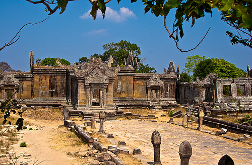
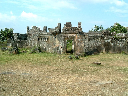
The temple has an axial layout, along the axis from north to south. An ascending road with a length of 788 meters passes 5 gopur, connected to each other by stairs and walkways for walks (a prototype of Mount Meru). The first staircase with a length of 76.8 meters was once guarded by sculptures of lions, comprising a 162 step carved in stone and leading to a platform 30 meters wide and framed by naga. The 5th gopur, a cruciform structure leads to the 2nd road, 267 m long, which runs between the 2nd rows of 65 columns, in the form of stylized lotus buds, leads to the stairs, to the 4th gopur. Another 150 m long road framed by 35 columns leads to the third, largest gopur in the complex. It is framed by two rectangular buildings. These buildings include galleries and elongated halls, for which they received the name of the palaces. Their facades play the role of a kind of wings, creating an impressive facade with a length of 99 m.