Location: Shahdol District Map
Area: 437 km²
MP Tourism, White Tiger Lodge, Tala (07653) 26 5308
Open: Oct- Jun
Bandhavgarh National Park is a nature reserved situated in Shahdol District in India. Bandhavgarh National Park covers an area of 437 km² that were established here in 1968. The best time to come to the nature reserve is between October and June during driest and coldest months of the year. Between July and September the nature reserve is closed due to dangerous flush rains. Additionally the national park has the highest density of tigers including a sizeable colony of white tigers. These beautiful and graceful animals are best viewed from a windows of vehicle rather than encounter in the wild jungle. This explains why tourists come here on safaris that are allowed inside Bandhavgarh twice a day.
Fort
A 2 thousand year old fort is built on the hill of Bandhavgarh .
Forest
The forest area of Bandhavgarh is full of different types of flora
and fauna. The forest has all kinds of wildlife and trees including
Nilgai and Chinkara .
Wildlife
There are 22 species of animals and 250 species of birds in this
national park. These wildlife can be seen riding on elephant or
sitting in a vehicle.
The park entrance is in the small town of Tala. Most tourists will travel to Tala via Umaria, about 30km away. Buses leave from the bus station there from 7 a.m. in the morning. You can reach the bus station by rickshaw or by walking straight ahead from the train station, over the roundabout and then following the street signs for about 3 kilometers. The last bus to Umaria leaves from Tala at approximately 5pm.
Tala itself is so small that you can easily reach everything on foot. There are several buses to Umaria every day. The last one at about 5 p.m.
The number of accommodations is relatively limited. During peak
travel times, it may make sense to reserve a room in advance.
Kum
Kum House, Rewa Road, Tala, Madhya Pradesh (inside the park). A simple
room with a double bed and an Indian style toilet costs ₹ 250. The price
is a bit negotiable and may be a little cheaper in the low season. There
are also even better rooms that have a cooler in addition to a normal
ceiling fan. The attached restaurant serves simple Indian food (rice,
dal, chapatti and vegetables) for ₹50.
Mythological and Legendary Origins
According to local legends and
references in ancient Hindu texts like the Narad Panch Ratra and Shiva
Purana (or Shiv Sanhita Puran), Lord Rama gifted the hilltop fort to his
brother Lakshmana to watch over Lanka (Sri Lanka). Hanuman and his
vanara army are said to have built or fortified the steep cliffs, making
the fort nearly impregnable. These stories link the site to the Treta
Yuga and underscore its deep cultural importance in Hindu mythology.
Ancient Archaeological Evidence
Human activity in the region
dates back over 2,000 years, with evidence from rock shelters, man-made
caves, rock paintings, and inscriptions. Brahmi script inscriptions
(some from the 1st century BC to 1st–2nd centuries AD) record donations,
royal names, and historical events. These caves, now often used as dens
by tigers and other wildlife (including for rearing cubs), provide key
archaeological insights into early settlements.
The earliest
documented ruler associated with the fort is linked to the Magha dynasty
(around the 1st–3rd centuries AD), including figures like Vashishtiputra
Bhimasena. Inscriptions mention King Bhimsen around 300 AD during the
Bharshiva/Vakataka period.
Dynastic Rule and the Fort as Seat of
Power
The fort served as a strategic hilltop stronghold (on a
tabletop mountain with panoramic views) and seat of power for successive
dynasties due to its defensible position and control over surrounding
forests:
Early dynasties (post-Vakataka): Included the Sengars,
Kalachuris (Rajput clans), and possibly influences from broader empires
like Mauryan, Sunga, or Gupta periods in the broader region (though
direct control varied).
Baghel dynasty (starting around the 12th–13th
centuries): They became the dominant rulers, holding the fort until the
early 17th century. There was a brief interregnum by the Kuruvanshees
(1495–1535 AD).
Key event in 1617 AD: Baghel ruler Maharaja
Vikramaditya Singh (or his successor) shifted the capital ~130 km away
to Rewa for strategic and administrative reasons. The Baghels then
adopted the title Maharajas of Rewa.
After the shift, the fort
and surrounding area were gradually abandoned. Human pressure decreased,
allowing dense sal-dominated moist deciduous forests, bamboo, and
grasslands to regenerate. The last inhabitants reportedly left around
1935 AD. The fort fell into ruins but retains remnants like temples
(e.g., associated with Lakshmana or deities), statues (including of
Vishnu), ponds, and fortifications.
Colonial Era to Hunting
Reserve
Under the princely state of Rewa (part of the Baghel
lineage), the Bandhavgarh forests became the exclusive private
"Shikargaah" (hunting reserve) of the Maharajas. Access was restricted
to the royal family and invited guests, with exclusive rights for tiger
hunting. This royal protection inadvertently helped conserve the habitat
and wildlife by limiting broader exploitation, though it was not formal
conservation.
A notable event in wildlife history: In 1951, Maharaja
Martand Singh of Rewa captured a rare white tiger cub named Mohan from
the forests of the Rewa state (Bandhavgarh area). Mohan became the
progenitor of most captive white tigers worldwide and is preserved
(stuffed) in the Baghel Museum near the park.
Post-Independence
and Establishment as Protected Area
India's independence (1947) and
the merger of Rewa into Madhya Pradesh (1956, with full integration
processes) ended princely privileges. The area came under state control,
but lax regulation led to forest degradation, increased poaching, and
habitat loss.
Maharaja Martand Singh, deeply concerned about the
decline, advocated for protection. On his proposal:
1968: An
initial core area of 105 km² (primarily the Tala range) was notified as
Bandhavgarh National Park. This marked the shift from royal hunting
grounds to a formal wildlife sanctuary/national park. Poaching was
curtailed, and habitat protection began.
1972: India's Wildlife
Protection Act provided a stronger legal framework.
1982: Expansion
to 448.84 km², incorporating additional ranges (Khitauli, Magdhi,
Kallawah) alongside Tala.
1983: Creation of Panpatha Wildlife
Sanctuary (245.85 km²), later merged into the core.
1993: Inclusion
in Project Tiger (launched nationally in 1973). Bandhavgarh became a
Tiger Reserve, with the core area expanded to approximately 694–716 km²
(including Panpatha) and a buffer zone of ~437–820 km², for a total
reserve area of about 1,536 km². This strengthened anti-poaching,
habitat management, and tiger conservation efforts.
Legacy and
Significance
The historical royal protection and limited access
contributed to the park's exceptionally high tiger density today (one of
India's highest). The fort's caves and ruins add archaeological value,
while the mythological ties enhance cultural tourism. Challenges like
disease outbreaks (e.g., past gaur losses from cattle-borne illness,
addressed by reintroduction from Kanha in 2012) and human-wildlife
interfaces have been managed through ongoing conservation.
Bandhavgarh exemplifies the transition from a dynastic stronghold and
royal hunting preserve to a premier biodiversity hotspot and tiger
conservation success story under Project Tiger. Visitors can explore the
fort (with permission/trek) alongside safaris in zones like Tala
(historically richest), Magdhi, and Khitauli.
Sources for this
history primarily draw from the official Bandhavgarh Tiger Reserve
website, Madhya Pradesh tourism records, Wikipedia summaries of
archaeological and establishment facts, and corroborated historical
accounts. Minor variations exist in exact dynasty dates across sources,
but the broad sequence (ancient inscriptions → Magha/Vakataka → medieval
dynasties culminating in Baghels → abandonment → modern protection) is
consistent.
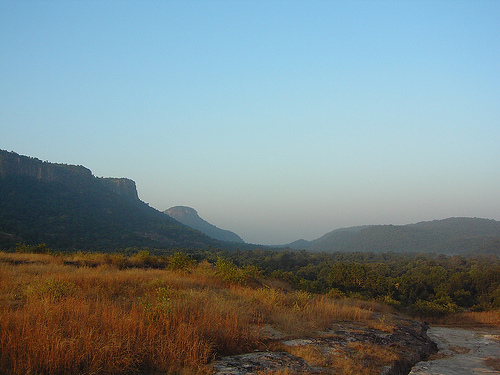
The hilly landscape is dominated by a plateau on which the Maharajas' fort once stood. In the surrounding area there are grassy areas rich in wildlife that emerged from swamps that were once created to protect the fort. Some of these swamps still exist. Sal forests also dominate.
The park's best-known animal species is the Bengal tiger, of which
almost 50 animals lived in the park in 1997. The big cats are not very
shy and are particularly easy to observe here.
A white tiger was
captured in this area in 1957, and its offspring can be seen in zoos and
circuses around the world. Other predator species in the area include
leopard, striped hyena, sloth bear, wild dog, cane cat, golden jackal,
spotted musang and Indian mongoose. The large herbivores are represented
by sambar deer, axis deer, Indian muntjacs, spotted chiles, four-horned
antelopes, Indian gazelles, Nilgau antelopes, and wild boars. Among the
mammals, the Indian pangolin and the langur should also be mentioned.
There are also around 200 species of birds in the park.
In 1995
there was still a remaining population of gaur in the park, but the huge
wild cattle disappeared in the following years for unknown reasons. The
gaur has now been reintroduced to the park. In 2011, 19 animals and 31
animals in 2012 were brought from Kanha National Park to Bandhavgarh.