Location: Uttarakhand Map
Area: 1553 km2
The Gangotri Glacier is a glacier in the Indian state of
Uttarakhand, which is one of the largest glaciers in the Himalayas
with an estimated volume of over 27 km³. It is around 30 km long and
between 2 and 4 km wide; its area was around 144 km² in 2010.
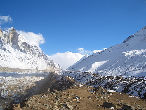
The glacier's catchment area is framed by mountains of the
Gangotri group: the Chaukhamba (7138 m), Satopanth (7076 m),
Kedarnath (6940 m), Bhagirathi (6856 m), Janhukut (6805 m), Meru
(6672 m), Kharchakund (6612 m) and Shivling (6543 m). A number of
tributary glaciers feed the main river, the most important being the
Kirti Bamak, Ghanohim Bamak, Swachhand Bamak and Maiandi Bamak, plus
the lower-lying Raktavarn, Chaturangi and Meru glaciers, which are
no longer connected to the main glacier. Accumulation occurs
primarily in the winter months of December to March; the
contribution of snowfall during the summer monsoon is uncertain.
The Bhagirathi, one of the source rivers of the Ganges, rises
from the Gangotri glacier. The glacier gate is called Gaumukh
(roughly: “mouth of the cow”) by Hindus because of its former
appearance. As the main source of the Ganges, the glacier has great
religious significance in Hinduism and attracts thousands of
pilgrims every year. About 18 km or a day's walk away is the town of
Gangotri with the Ganga Temple, which is dedicated to the goddess
Ganga and is part of the Chota Char Dham pilgrimage route.
Even though large parts of the glacier in the ablation zone are
covered with rock debris - resulting in a delayed response to
climate changes - there is a significant retreat of the glacier. Due
to debris coverage and errors in the maps, information about the
retreat of the glacier varies greatly. Analysis of satellite images
by the United States Geological Survey showed a loss of more than
850 m in length between the early 1980s and the mid-2000s. An
analysis of satellite data from 2016 showed a lower retreat rate of
almost 18 m per year between 1965 and 2015, corresponding to a loss
in length of slightly less than 900 m. Main and secondary glaciers
lost a little more than 10 cm in thickness per year from 1968 to
2014 . While the decline in glacier length in the years before 2015
was less than the long-term average, the loss of mass was higher.
NASA, together with scientists from the United States Geological Survey (USGS) and the National Snow and Ice Data Center (NSIDC), is developing a global inventory of all the world's glaciers to help researchers trace the history of each one of them. According to them, the Gangotri glacier, which is currently 30.2 km long and 0.5 to 2.5 km wide, is one of the largest in the Himalayas. This glacier has not stopped retreating since measurements began in 1780. Data for 61 years (1936-96) showed that the total retreat of the Gangotri glacier was 1147 m, with an average rate of 19 m per year. However However, in the last 25 years of the 20th century it has retreated more than 850 meters (34 meters per year), and 76 meters between 1996 and 1999 (25 meters per year).
Location and Setting
It lies in Uttarkashi District, Uttarakhand,
in the upper Bhagirathi River catchment, bordering the Tibet/China
region. Coordinates center around 30°50′N 79°10′E (more precisely
spanning ~30°43'22" to 30°55'49" N and 79°4'41" to 79°16'34" E). It
flows roughly northwest in the Garhwal Himalayan zone north of the Main
Central Thrust (MCT). The glacierized catchment area is approximately
258 km², with the Gangotri system itself covering around 109 km²
(variations reported depending on inclusion of tributaries).
The
glacier occupies a deep glacial trough in the Higher Himalayan
crystalline terrain, composed of rocks such as granites, garnet mica
schist, quartz biotite schist, kyanite schist, augen gneiss, and banded
augen gneiss. Elevations range from about 4,120 m at the snout to over
7,000 m at the headwall.
Dimensions and Structure
Commonly
cited dimensions are approximately 30 km (30.2 km) in length and 2–4 km
wide (varying from 0.5–2.5 km across sections), with an ice volume
exceeding 27 km³ (alternatively cited around 20 km³). Reported areas
include ~143 km² or up to ~200 km² for broader ice cover. The main trunk
has been measured at ~29 km long with an average width of ~1.85 km and
area ~56.6 km² in some assessments. It is a temperate valley glacier
with significant debris cover in the ablation zone.
Origin,
Tributaries, and Morphology
The glacier originates in a cirque below
Chaukhamba peak (the highest in the Gangotri Group, ~7,138 m). It is fed
by numerous tributaries. The three main ones are:
Raktvarn
Glacier (~15.9 km long, with sub-tributaries like Thelu, Swetvarn,
Nilambar, Pilapani; 7 tributaries total in some descriptions)
Chaturangi Glacier (~22.45 km long, including Kalindi Bamak;
sub-tributaries Seeta, Suralaya, Vasuki)
Kirti Glacier (~11.05 km
long, with 3 tributary glaciers)
There are more than 18 smaller
tributary glaciers overall, plus direct contributors such as Swachand,
Miandi, Sumeru, and Ghanohim. Several others (e.g., Maitri, Meru,
Bhrigupanth ~14.95 km², Manda) drain into the Bhagirathi downstream of
the main snout.
The glacier exhibits classic valley glacier
morphology, with depositional features (talus cones, snow-avalanche
fans, snow-bridges, dead ice mounds) and erosional ones
(pyramidal/conical peaks, serrated ridge crests, glacial troughs, smooth
rock walls/tails, waterfalls, rock basins, gullies, and glacial lakes).
Longitudinal and transverse crevasses are common, along which ice blocks
calve. The ablation zone features a thick supraglacial moraine/debris
cover, numerous supraglacial lakes (especially in the central/subsiding
sections due to fast degeneration), and ice cliffs/sections melting into
pools.
Snout, Hydrology, and Surrounding Peaks
The terminus
(snout) is at Gomukh (Gaumukh, "cow's mouth"), resembling a cow's mouth,
at ~4,023 m (13,200 ft) elevation. It lies ~19 km upstream (by trek)
from Gangotri town (~3,100 m elevation) via the route passing Chirbasa
and Bhojwasa. Meltwater emerging from Gomukh forms the Bhagirathi River
immediately. The snout is near the base of Shivling peak (~6,543 m),
with Tapovan meadow nearby.
Retreat and Dynamics
Gangotri has
been receding since at least 1780, with acceleration noted after ~1971.
From 1935–2022, the frontal retreat totaled 1,727 ± 51 m (average ~19.8
m/year), though rates have varied (slower in some early periods like
1935–1965, higher in others, e.g., 30–50 m/yr 1960–1990; ~21 m/yr
2004–2010; 76 m 1996–1999). Over ~25 years into the early 2000s, >850 m
retreat was documented. The ablation zone shows subsidence, expanding
supraglacial lakes, and debris-covered thinning. Surface velocities vary
seasonally/yearly due to subglacial drainage evolution.
Ongoing
monitoring uses satellite data (e.g., SAR, ASTER, Landsat), GPS, and
field surveys due to challenging access and data gaps in ice
thickness/volume/mass balance.
NASA, in collaboration with scientists from the United States Geological Survey and the National Snow and Ice Data Center, is developing a global inventory of all the world's glaciers to help researchers track the history of each glacier. According to them, the Gangotri glacier, which is currently 30.2 km long and between 0.5 and 2.5 km wide, is one of the largest in the Himalayas. This glacier has continued to retreat since measurements began in 1780. Data over 61 years (1936-96) showed that the total retreat of the glacier was 1,147 m, with an average rate of 19 m per year. During the last 25 years of the 20th century, it retreated by more than 850 meters (34 meters per year), and by 76 meters between 1996 and 1999 (25 meters per year).