Location: Jaisalmer, Rajasthan state Map
Constructed: 1156 AD
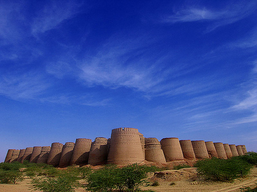
Jaisalmer Fort, also known as Sonar Quila (Golden
Fort), Swarna Durg, or Sonar Kella, is a massive hilltop
fortification in Jaisalmer, Rajasthan, India, built from yellow
sandstone that gives it a distinctive golden hue—tawny by day and
honey-gold at sunset, blending with the Thar Desert landscape.
It
stands on Trikuta Hill (a three-peaked hill), rising about 250 feet
(76 m) above the surrounding desert plains, measuring roughly 1,500
ft (460 m) long and 750 ft (230 m) wide, defended by nearly 100
bastions (99 total, with 92 added or rebuilt 1633–1647). The fort is
one of the world's few "living forts," with around 4,000 residents
(about one-quarter of the old city's population, mostly descendants
of Bhati Rajputs and Brahmins) still living within its walls,
alongside temples, palaces, havelis (mansions), shops, and narrow
alleys.
It is strategically located at the crossroads of ancient
trade routes, including branches of the Silk Road connecting India
with Central Asia, allowing the Bhati rulers to prosper from caravan
levies and tolls. In 2013, it was inscribed as a UNESCO World
Heritage Site (cultural criteria ii and iii) as part of the Hill
Forts of Rajasthan, recognizing its exemplary Rajput military hill
architecture and historical role.
Founding and Early History (12th Century)
The fort was founded
in 1156 CE by Rawal Jaisal (also Rao Jaisal or Rawal Jaisal Singh,
r. c. 1153–1168), a Bhati Rajput of the Yaduvanshi clan (claiming
descent from Lord Krishna via Pradyumna and Rao Bhati). Jaisal, the
eldest son of the Rawal of Deoraj/Lodhruva (an earlier capital), was
passed over for the throne in favor of a younger half-brother. He
established the new capital at Jaisalmer after dissatisfaction with
the vulnerable Lodhruva site (exposed to raids by Turko-Afghan and
Baloch tribes).
Legends attribute the site choice to a local
hermit (or sage) who advised Jaisal, or to a prophecy linked to
Krishna's Yaduvanshi lineage promising a kingdom on this spot. The
original structure began as a mud fort before being expanded in
sandstone. The Bhati kingdom's earlier territories had extended far
(from Ghazni to parts of modern Punjab and Pakistan), but invasions
pushed them southward to the desert region.
The kingdom thrived
on trade protection and taxation of caravans passing through the
desert routes.
Major Sieges and Medieval Period (13th–16th
Centuries)
Jaisalmer Fort endured numerous invasions due to its
wealth and strategic position.
Alauddin Khalji's Siege (c.
late 13th century, around 1299 CE): The most famous and devastating.
Rawal Jait Singh I (or Jethsi) provoked the Delhi Sultanate ruler by
a Bhati raid on a rich treasure caravan. Khalji's army laid a
prolonged siege (sources vary: up to 8–9 years or intense multi-year
campaign ending c. 1294–1299). Famine struck inside the fort; Bhati
women and children committed jauhar (mass self-immolation to avoid
capture/rape), while the male warriors, led by Mularaja (or Ratan
Singh), died fighting in a final sally. The fort fell briefly to the
Delhi Sultanate before Bhatis reoccupied it.
Afghan Chief Amir
Ali's Attack (c. 1530–1551, during Rawal Lunakaran's reign): As
defeat seemed imminent, Lunakaran slaughtered many womenfolk to
prevent capture (preventing full jauhar due to time). Reinforcements
arrived, and the defenders won, turning tragedy into victory.
Humayun's Attack (1541 CE): Mughal emperor Humayun assaulted the
fort en route to Ajmer; Rawal Lunakaran defended successfully.
Later, Lunakaran formed an alliance with the Mughals, marrying his
daughter to Emperor Akbar. Mughals exerted varying control over the
fort/kingdom afterward.
The Bhatis maintained
semi-independence through resistance, alliances, and the fort's
formidable defenses.
Mughal, British, and Modern History
Mughal influence persisted; the fort remained under their sway until
Maharawal Mulraj Singh II regained fuller control around 1762. In
1818, Mulraj signed a subsidiary alliance treaty with the British
East India Company (12 December 1818), making Jaisalmer a
protectorate. It retained internal autonomy and fort control in
exchange for British protection, receiving a 15-gun salute and
joining the Rajputana Agency.
Economic decline set in under
British rule: the rise of Bombay as a major port diminished overland
caravan trade. Partition of India (1947) further closed traditional
routes to Pakistan and beyond. Famines and droughts (e.g.,
1895–1900, 1941) compounded hardships.
Post-independence:
Maharawal Jawahir Singh (r. 1914–1949) modernized with
infrastructure, water, sanitation, and education. The kingdom
acceded to the Dominion of India in 1947; full merger into the
United State of Rajasthan occurred by 1949–1950 under Maharawal
Girdhar Singh. The fort saw strategic use in the 1965 and 1971
Indo-Pakistani wars.
Current Status, Conservation, and Legacy
The fort faces ongoing threats from water seepage (weak sedimentary
rock foundation), population pressure, inadequate
sanitation/drainage, seismic risks, and tourism impacts. It was
listed on the World Monuments Fund Watch List (1996, 1998, 2000);
restorations involved WMF, American Express, INTACH, and government
efforts, though coordination issues persist. It attracts hundreds of
thousands of visitors annually and gained fame from Satyajit Ray's
1974 film Sonar Kella (The Golden Fortress), based on his novel.
Materials and Overall Style
The entire fort is constructed
primarily from local yellow sandstone (technically Jaisalmer Golden
Limestone from the Jaisalmer Formation), which gives it a
distinctive tawny lion color by day that shifts to honey-gold at
sunset, providing natural camouflage in the desert landscape. This
stone enables intricate carving while offering durability in the
arid climate. The architecture is fundamentally Rajput military hill
fort style—emphasizing defense, elevation, and grandeur—with later
additions showing Indo-Islamic (Mughal-influenced) elements in
carvings, arches, and decorative motifs. Features include passive
cooling techniques: thick walls for insulation, jharokhas
(projecting latticed balconies) for ventilation and privacy, and
strategic orientation.
Dimensions: Approximately 1,500 ft (460 m)
long and 750 ft (230 m) wide.
Layout and Defensive
Architecture
The fort employs a triple-ringed defense system
typical of Rajput forts for layered protection:
Outermost
base wall (~15 ft / 4.6 m tall).
Main perimeter with 99 bastions
(92 rebuilt/enhanced 1633–1647 CE) and corner towers; circular
bastions and towers enhance flanking fire.
Inner walls forming a
~2.5-mile (4 km) upper bastion perimeter.
Access is via a
winding, zig-zag path through four fortified gates (pols),
preventing direct cavalry charges and allowing defenders to attack
from above:
Akhai Pol (first/outermost).
Suraj Pol (Surya
Gate, second).
Ganesh Pol (third, often noted as ornate).
Hawa
Pol (leading to the inner citadel).
This serpentine approach,
combined with bastions and high walls, exemplifies defensive
engineering. An ingenious ghut nali drainage system channels
rainwater from the highest point in four directions to manage rare
but intense desert downpours, though its effectiveness has decreased
with modern encroachments.
Royal Palace: Raj Mahal (Maharwal
Palace)
At the center stands the Raj Mahal, the former residence
of the Maharwals, a multi-storied complex (up to 7 stories
referenced in some descriptions) with balconies, jharokhas, small
courtyards, chambers, and ornate sandstone elements. It blends
Rajasthani and Mughal styles, featuring floral carvings (e.g., in
Gaj Mahal areas), pagoda-shaped cupolas, and decorative balconies.
Historic elements include saffron-orange handprints on walls from
Jauhar (mass self-immolation) during sieges (e.g., Alauddin Khalji
~1299 CE). Parts now serve as a museum displaying royal portraits,
weapons, attire, ornaments, and artifacts. Connected spaces include
Diwan-e-Khas (audience hall), Gaj Mahal (king's carved chamber),
open courtyards, and Rani Ka Mahal (Queen's Palace).
Religious Structures
Seven Śvetāmbara Jain temples (12th–16th
centuries CE) form a major complex inside the fort, built of yellow
sandstone with exquisite carvings rivaling Dilwara temples (Mount
Abu). They feature:
Intricate animal, human, floral, and
geometric carvings on walls, pillars, mandapas (octagonal halls),
porches, shikhars (towers crowned with amalaka), and devakulikas.
Frescoes, mirrors, and detailed stonework.
Layouts with
garbhagrihas (sanctums), surrounding shrines, and mandapas.
Highlights:
Parshvanatha temple (oldest): Black marble idol of
Parshvanatha under a multi-headed serpent hood; main shrine with 52
small devakulikas; ornate porch, torana (archway); carvings of
animals/humans on garbhagriha wall.
Sambhavanatha temple (built
by Askaran Chopra): Over 600 idols; includes Gyan Bhandar library
(~1,000 palm-leaf/Bhojpatra manuscripts from 12th century, some
painted).
Ashtapadh temple (by Chopra Panchaji): Images of
Vishnu, Kali, Lakshmi alongside Jain deities.
Others:
Chandraprabha (completed 1509, mandapa), Shitalanatha, Shantinatha &
Kunthunatha (carvings), Rishabhanatha (glass-protected idol).
Laxminath Temple (Hindu, dedicated to Lakshmi and Vishnu) is
another key internal structure.
Residential Areas and Havelis
As one of the world's largest living forts (UNESCO Hill Forts of
Rajasthan, 2013), it houses ~4,000 residents (mostly Brahmin/Rajput
descendants). Inside are merchant/noble havelis with ornate
jharokhas, carved doorways, arches, balconies, and sandstone
latticework blending Rajput and Islamic styles (e.g., elephant
motifs, warriors on plinths in examples like Nathmal Haveli). Many
feature museums or ongoing habitation.
Unique and Engineering
Highlights
Camouflage and climate adaptation → Stone color and
thick walls/jharokhas.
Carvings → Profuse figurative and
decorative work.
Conservation challenges → Water seepage,
population pressure, seismic risks on sedimentary rock, leading to
collapses (e.g., Queen's Palace sections); past restorations by
World Monuments Fund, INTACH, etc.