Location: Arunachal Pradesh Map
Area: 1985 km2
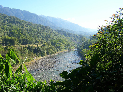
Namdapha National Park (also Namdapha Tiger Reserve) is a vast protected area of 1,985.23 km² (core area approximately 1,808 km², buffer around 177 km²) in Changlang district, Arunachal Pradesh, northeastern India, near the Myanmar border (and close to the India-Myanmar-China trijunction). It ranks as India's fourth-largest national park and a key Eastern Himalayan biodiversity hotspot, with elevations ranging from about 200 m in the lowlands to 4,571 m at Dapha Bum peak. The Noa-Dihing River (a Brahmaputra tributary) flows north-south through the park, along with numerous streams, pools, and salt licks. Vegetation spans tropical evergreen rainforests (northernmost lowland evergreen rainforests at this latitude), moist deciduous, subtropical, temperate broadleaf/mixed, coniferous forests, and alpine zones, supporting over 1,000 floral species (including many endemics and affinities with Indo-Malayan flora) and roughly 1,400 faunal species.
Namdapha National Park is located in Changlang District, Arunachal
Pradesh, in northeastern India, near the international border with
Myanmar and close to the trijunction area with China. Its approximate
central coordinates are 27°29′N 96°23′E, with the park spanning roughly
27°23′N to 27°39′N. The nearest town is Miao, and it lies a few
kilometers away amidst misty hills. The park sits between the Dapha Bum
range of the Mishmi Hills (north) and the Patkai range
(south/southeast), making it part of the Eastern Himalayan biodiversity
hotspot and contiguous with Myanmar's forests, such as the Hukawng
Valley Tiger Reserve.
It covers a total area of 1,985.23 km² (core
zone ~1,808 km², buffer ~177 km²), making it one of India's largest
national parks and the fourth largest overall. It was established in
1983 and is also a tiger reserve.
Topography and Elevation
The
park features steep, rugged, and largely inaccessible mountainous
terrain with few gentle slopes. It spans a dramatic altitudinal range
from about 200 meters in the lowland valleys to 4,571 meters at the
highest point, Dapha Bum peak. This extreme vertical gradient creates a
compressed ecological transition uncommon elsewhere. Average elevations
in sampled areas range from around 1,500–2,200 meters depending on the
zone. The terrain is crisscrossed by valleys, ridges, and deep gorges,
with dense vegetation and undergrowth making much of the interior
difficult to access. Seasonal snow cover occurs above approximately
2,700 meters between December and March in higher reaches.
Climate
Due to its location and elevation range, the climate varies
from tropical/subtropical in the lowlands to temperate and alpine at
higher altitudes. Lowland areas support the world's northernmost lowland
evergreen rainforests at ~27°N latitude. Annual rainfall is heavy and
monsoon-driven, typically ranging from 2,000–6,000 mm (with some studies
noting 2,500–3,000 mm at lower sites like Deban), concentrated from May
to September. Temperatures average 10–27°C annually in lower areas, with
summer highs around 22–30°C and winter lows dropping to 0°C or below (or
even cooler at altitude). Higher elevations experience cold winters with
snow. Humidity remains high year-round, contributing to lush vegetation.
Hydrology: Rivers and Water Features
The park lies within the
catchment of the Noa-Dihing River (also called Noa Dihing or upper
Dihing), a tributary of the Brahmaputra River. This turbulent river
originates at the Chaukan Pass on the Indo-Myanmar border and flows
roughly east to west across the park, forming a key hydrological artery.
Other significant rivers and streams include the Namdapha, Diyun, Dapha,
Kamlang, Lai, Lati, and Lang rivers, along with numerous perennial
rivulets, forest pools, swamps, and natural salt licks. These waterways
create diverse aquatic and riparian habitats and contribute to the
park's moisture and biodiversity.
Vegetation and Ecological Zones
The extreme altitudinal and topographic diversity drives a remarkable
array of vegetation types, transitioning from tropical wet evergreen and
dipterocarp-dominated lowland rainforests (including the northwestern
extent of the Mizoram-Manipur-Kachin rain forests ecoregion) through
subtropical hill forests, temperate broadleaf and mixed forests,
coniferous zones, to alpine meadows and shrublands at the highest
elevations. Lowlands feature dense evergreen forests with thick
undergrowth of canes, bamboos, wild bananas, and epiphytes. Higher zones
include secondary forests and areas with unique species like certain
Pinus and Abies (rare in India). Over 1,100 vascular plant species are
documented across more than 200 families, plus lichens, bryophytes, and
pteridophytes. The park harbors notable plants such as root parasites
(e.g., Sapria himalayana). Three broad vegetation zones are often
described: subtropical, temperate, and alpine.
Geological Context
Geologically, the park lies in the tectonically active Eastern Himalayan
orogenic belt, shaped by the collision of the Indian and Eurasian
plates. The Patkai and Mishmi Hills consist primarily of sedimentary and
metamorphic rocks (sandstones, shales, etc.) with steep slopes prone to
landslides, especially during heavy monsoons. Details on specific
formations are limited in general sources, but the ruggedness results
from ongoing uplift and erosion processes.
This combination of steep
topography, wide elevation gradient, heavy orographic rainfall, and
river systems creates one of the most biodiverse protected areas in the
Eastern Himalayas, with habitats ranging from lowland tropical forests
to alpine zones in a relatively compact area. The terrain's
inaccessibility has helped preserve its pristine character but also
poses challenges for exploration and management.
Indigenous Peoples and Human Presence
Indigenous communities such
as the Singpho (linked to the name), Lisu (also called Yobin), Tangsa,
Chakma (refugees from Bangladesh settled by the Indian government in the
1960s near Miao and the park's western edge), and others like Miji
Mishmi have long inhabited or used the area. They rely on forests for
food, medicine, firewood, rituals, ornaments, and income via hunting,
fishing, gathering, and shifting cultivation (jhum). Traditional
knowledge and beliefs among these groups often support biodiversity
conservation, though tensions arise from resource use inside the park.
Lisu settlements (population around 3,000) expanded inside park
boundaries over decades (e.g., from ~65 families in 2004–05 to 160 by
2012–13), leading to clearances (thousands of hectares affected
historically). Chakma communities also harvest resources. Some Lisu
arrived or were noted since the 1940s; their tribal status was revoked
in 1979 and partially restored later, contributing to marginalization
and conflicts with authorities.
Early Recognition and WWII
Context
The area's dense, impenetrable rainforests and rugged terrain
gained international notice during World War II. It lay along the famous
"Hump" air route, where Allied aircraft flew supplies from bases like
Chabua (Assam) over the Himalayas/Patkai to Kunming, China, to support
Chiang Kai-shek's forces against Japanese advances. Turbulence, poor
weather, and the remote forests caused numerous plane crashes in the
latter war years, highlighting the region's challenging wilderness
(though not directly tied to formal protection).
Post-independence,
in 1947 (or shortly after), W. Maiklinjalm, Forest Advisor to the
Governor of Assam, proposed declaring the area a national park due to
its pristine wilderness. The proposal was ignored. Relevant files
mysteriously disappeared during the 1962 Indo-China War but were
recovered around 1969, paving the way for formal protection. The area
was originally classified as reserve forest.
Establishment and
Formal Protection
1972: Declared a Wildlife Sanctuary.
1983:
Designated a National Park on 12 May under the Wildlife (Protection)
Act, 1972; simultaneously declared a Tiger Reserve under Project Tiger
(some notifications cite 15 March 1983 for the TR status) — the 15th in
India.
This recognized its exceptional biodiversity, including
the rare occurrence of four big cats (tiger, leopard, clouded leopard,
snow leopard) in one protected area, plus species like hoolock gibbon
(India's only ape), elephants, gaurs, takin, red panda, and endemics.
Post-Establishment: Surveys, Discoveries, and Conservation
Milestones
Formal surveys and research intensified:
The
Namdapha flying squirrel (Biswamoyopterus biswasi), a critically
endangered endemic, was first collected here and scientifically
described in 1981 (last confirmed record around that time in one
valley).
Botanical Survey of India contributed flora documentation
(e.g., 1996).
Avifauna: ~425 bird species; papers from 1990; first
mid-winter waterfowl census in 1994 recorded the critically endangered
white-bellied heron; notable species include rufous-necked hornbill,
Ward's trogon, white-winged wood duck.
Lepidoptera richness
highlighted in Bombay Natural History Society (BNHS) 2014 national camp,
revealing rare butterflies/moths.
Camera-trap studies (e.g., 2008
over 1,500 trap-days; 2012) documented tigers and other carnivores but
faced interruptions (poachers fired on researchers and stole equipment
in 2012).
It is on UNESCO's tentative World Heritage list (with
Kamlang WLS and Jairampur FD), noted as one of Asia's last great remote
wildernesses with steep, inaccessible terrain and high ecological value.
In 2024, it was declared an Eco-Sensitive Zone to further regulate
activities around the core area.
Challenges, Threats, and
Wildlife Status
Despite protection, large mammal populations (tigers,
leopards, major ungulates like sambar/gaur/serow) appear depleted
compared to expectations for its size and habitat diversity. A 2008
camera-trap study detected no tigers or leopards and low ungulate
sightings; transect surveys (2008–2012) recorded far fewer than
comparable reserves like Pakke. Anecdotal evidence suggests healthier
populations (tigers, elephants) until the early 1990s, with declines
linked to intensive hunting.
Major threats include:
Hunting/poaching by local and indigenous communities (for subsistence,
rituals, trade, income) — culturally integral but unsustainable.
Encroachment and forest clearance inside/outside (e.g., Lisu
settlements; Changlang district lost ~2.5% forest cover since 2001;
broader Arunachal projections of major loss).
Extraction of forest
products (firewood, NTFP; estimates of thousands of tonnes annually).
Human population growth, malaria/erosion driving pressure,
human-wildlife conflict.
Historical tensions: 1980s evictions of Lisu
settlements led to retaliation; later community initiatives (schools,
healthcare, alternatives like pig-rearing/handicrafts/tourism by
researchers like Aparajita Datta) temporarily improved relations and
reduced hunting, but relocation offers were rejected, cooperation waned.
Proximity to international borders adds complexity (contiguous
forests but potential security/illegal cross-border activity).
Current Status and Significance
Namdapha remains a premier wilderness
and research site, managed by the Arunachal Pradesh Forest Department
(under Project Tiger/NTCA nationally). Entry is via Miao; Deban forest
camp/inspection bungalow offers access along the Noa-Dihing.