Location: Hokkaido Island Map
Area: 904.81 km2 (349.35 mi2)
The Akan Mashū National Park (Japanese 阿寒摩周国立公園 ) is a national park on Hokkaidō, the northernmost of Japan's main islands. The park was established on December 4, 1934. This makes it and Daisetsuzan National Park the two oldest national parks in Hokkaidō. The park area is 904.81 km², the second largest in Hokkaidō. The park area is classified as a national park with IUCN protection category II.
Best Time to Visit
Summer (June–September): Mild weather ideal for
hiking, canoeing, lake cruises, fishing, and wildflower viewing.
Greenery peaks, with fewer crowds mid-week.
Autumn (late
September–October): Vibrant foliage (koyo) in reds, oranges, and
golds—highly popular with Japanese visitors. Clearer skies possible for
lake views.
Winter (December–March/April): Snowy wonderland with
frozen lakes, snowshoeing, ice fishing, rime ice (frost-covered trees),
and "frost flowers" on Lake Akan. Fewer crowds, but very cold (sub-zero
temperatures) and limited access.
Spring: Late thaw (around May)
brings colorful flowers like Meakan-kinbai, but trails may be muddy or
closed.
Check forecasts and trail conditions—Hokkaido weather
changes quickly. Autumn and summer suit most first-timers.
How to
Get There
The park splits into western (Lake Akan/Akanko Onsen) and
eastern (Lake Mashu, Kussharo, Kawayu Onsen) sections.
By Air: Fly to
Kushiro Airport (KUH, ~1.5 hours from Tokyo Haneda) or Memanbetsu
Airport (~1.75 hours). From Kushiro, Akan Bus Airport Liner reaches
Akanko Onsen in ~70 minutes (¥2,190 one-way, 3–5 daily).
From
Sapporo: ~4.5–5 hours by car or bus/train combo (Super Ozora limited
express to Kushiro ~4.5 hours).
Rental Car (Recommended): Essential
for flexibility, as public buses are infrequent. Available at airports;
drive times: ~1 hour from Kushiro to Lake Akan, longer between sections.
Buses/Tours: Akan Bus offers airport transfers and sightseeing tours
(e.g., White Pirika in winter). Seasonal passes available in peak
periods.
Public transport works for bases like Akanko or Kawayu but
limits spontaneity.
Key Attractions and Activities
Lake Akan
(Western Section):
Famous for marimo (rare spherical algae
balls)—view at the exhibition center or buy souvenirs.
Akanko Onsen
town: Walkable base with ryokans, shops, and Ainu Kotan village
(cultural performances, crafts).
Short trails like Bokke (bubbling
mud pools) and Mt. Hakuto for sea-of-clouds views at sunrise.
Lake Mashu (Eastern Section):
One of the world's clearest lakes,
often misty—view from Observation Decks 1–3 (no swimming/access to
shore).
Hike to Mt. Mashu summit (2–3 hours one way from Deck 1).
Lake Kussharo:
Largest lake; canoeing, SUP, fishing, or swimming
possible.
Wakoto Peninsula: Easy loop trail with hot springs and
views.
Whooper swans in winter.
Other Highlights:
Mt.
Meakan: Rewarding volcanic hike with craters and scenery (loop trail,
several hours; check conditions).
Mt. Io (Iozan): Sulfur vents,
steaming ground—easy walks, boiled eggs at stalls.
Kawayu Onsen:
Acidic hot springs; base for eastern exploration.
Guided experiences:
Snowshoeing, fat-biking, forest walks, sunrise tours (e.g., Tsuruga
Adventure Base SIRI at Lake Akan—English-speaking guides recommended,
especially for bears).
Visitor centers (e.g., Kawayu Eco Museum
Center, Akan Nature Center) provide maps, updates, and advice.
Practical Visiting Tips
Transportation & Pacing: Rent a car for
independence. The scenic Akan-Mashu Odan Road connects lakes with
viewpoints (Sokodai, etc.). Allow 2–4 days to cover both sections
without rushing.
Wildlife & Safety: Brown bears present—hike in
groups, make noise, carry bear spray/bells if available. Stick to
trails; check advisories at centers. Guided tours are safest for deeper
exploration.
Onsen Etiquette: Tattoo-friendly options exist, but
confirm. Many ryokans have rotenburo (outdoor baths). Kawayu has
mixed-gender or unique acidic springs.
Fees & Permits: Park entry is
free, but some activities (boat tours, guided hikes) or facilities
charge. No major entrance fees.
What to Bring:
Layers (even
summer nights cool; winters extreme).
Rain gear, sturdy hiking shoes.
Insect repellent (summer), sunscreen.
Cash (some rural spots limited
cards), power bank.
Bear safety items, headlamp for early/late
activities.
Food & Culture: Try local specialties like himemasu
(sockeye salmon), venison ramen, or Ainu-inspired dishes. Marimo-themed
souvenirs. Visit Ainu Kotan for dances and learning.
Accessibility &
Rules: Trails vary in difficulty; some wheelchair-friendly paths near
towns. Respect nature—no littering, stay on paths. Check for seasonal
closures (e.g., winter hiking limits).
Where to Stay
Lake Akan
Onsen: Convenient hub with ryokans like Akan Yuku-no-Sato Tsuruga (lake
views, onsen). Mix of hotels, minshuku, and luxury options.
Kawayu
Onsen: Quieter eastern base.
Book ahead in peak seasons (autumn,
summer weekends). Ryokans often include meals and onsen access.
Sample Itineraries
3 Days (Base at Lake Akan): Day 1: Arrive, explore
town/marimo/Ainu. Day 2: Hike or guided tour + onsen. Day 3: Drive to
Mashu/Kussharo/Iozan, return.
Winter Focus: Snowshoe on frozen Lake
Akan, ice fishing, onsen hopping.
Extend with nearby Kushiro Wetlands
(cranes) or Shiretoko.
Prehistoric Geological Formation (Hundreds of Thousands to Thousands
of Years Ago)
The park’s landscape was shaped entirely by volcanic
activity in the Chishima (Kuril) Volcanic Zone. Major events include:
Akan Caldera (southwestern section): Formed roughly 150,000 years ago
(or between several hundred thousand and 150,000 years ago) by massive
eruptions. Subsequent activity from volcanoes like Mt. Oakan (1,371 m)
and Mt. Meakan (1,499 m, still active) divided an earlier “Old Lake
Akan” around 10,000 years ago, creating today’s Lake Akan (≈25.9 km
circumference, 42 m deep) along with smaller lakes like Panketo,
Penketo, and Onneto.
Kussharo Caldera (northern section): Originated
from a colossal eruption 130,000–100,000 years ago, forming Japan’s
largest caldera lake, Lake Kussharo (≈80 km²). It features geothermal
sites like Wakoto Peninsula and occasional dramatic ice pressure ridges
in winter.
Mashu Caldera (northeastern section): Created by an
enormous eruption ≈7,000 years ago. Lake Mashu (one of the world’s
clearest lakes, with historical transparency up to 41.6 m in 1931, now
26–29 m) filled gradually over the following millennia. It has no
inflowing or outflowing rivers, relying on precipitation.
Ongoing
volcanism produced features like Mt. Io (Iozan/Atosanupuri, 508 m) with
over 1,500 fumaroles, boiling mud pools (bokke), hot-spring waterfalls
(e.g., Onnetō Yu-no-taki), and unique ecosystems (e.g., subarctic
coniferous forests, hardy plants near sulfur vents, and rare marimo
algae in Lake Akan). These processes continue to influence the park’s
topography, hot springs (e.g., Kawayu Onsen), and biodiversity.
Indigenous Ainu Inhabitation and Cultural Significance (Ancient Times to
19th Century)
The Ainu (indigenous people of northern Japan,
including Hokkaido—known to them as Ainu Mosir) have lived in the
Akan-Mashu region for thousands of years, long before Japanese
settlement. They traditionally sustained themselves as hunters, fishers,
and gatherers in harmony with nature, viewing all living things as kamuy
(spirits) with purpose—e.g., brown bears as reincarnated mountain gods
providing sustenance.
Ainu place names and legends are embedded
in the landscape:
Lake Mashu was called Mashin (“Lake of the Devil”)
with superstitions of curses or spirits beneath its foggy waters.
Lake Onneto means “old, large lake” in Ainu.
Settlements like Akanko
Ainu Kotan (one of Hokkaido’s largest remaining Ainu villages, on Lake
Akan’s shores, with ≈120 residents in 36 households today) and Kussharo
Kotan preserved traditions.
Ainu performed rituals such as the
Iomante (Fire Festival for Sending Spirits Off), involving dances and
ceremonies to honor kamuy. Unlike many global national parks where
Indigenous presence was removed, Ainu communities have lived within the
park’s current boundaries for centuries. Heavy assimilation policies
during Japanese colonization (especially after the 1899 Hokkaido Former
Aborigines Protection Act) suppressed language, customs, and rights,
leading to population decline and cultural loss. Yet Ainu knowledge of
the land’s resources, spirits, and ecology endured.
Japanese
Colonization, Resource Extraction, and Early Conservation (Late
19th–Early 20th Century)
Hokkaido (formerly Ezochi) was rapidly
colonized during the Meiji era (1868 onward). Japanese settlers arrived,
and the region was developed for agriculture, mining, and tourism.
Sulfur mining at Mt. Io: From the late 1800s to early 1900s, the
mountain’s abundant sulfur (fumaroles and deposits) was extensively
mined and transported, playing a key role in Hokkaido’s economic
development and early infrastructure.
Maeda family private
conservation: In 1906, Maeda Masana (1850–1921, a former Vice-Minister
of Agriculture and Commerce) purchased ≈3,892–3,900 hectares around Lake
Akan from the government, initially intending farmland/pasture use.
Deeply moved by the pristine forests and scenery, he famously declared,
“This forest is not to cut but to see” (or “observe, not cut the
mountains”). He shifted focus to conservation, founding the Maeda Ippoen
Foundation, which still owns and protects much of the land today. Later
generations (e.g., Mitsuko Maeda) supported the Akanko Ainu Kotan
village, aiding cultural preservation alongside nature conservation.
This private initiative was instrumental in safeguarding the area
decades before official park status.
Hot springs were developed
(e.g., Akanko Onsen, Kawayu Onsen), and early tourism began, though
large-scale infrastructure came later.
Establishment as a
National Park (1934)
On December 4, 1934, the area was officially
designated Akan National Park—one of Japan’s earliest national parks
under the emerging system emphasizing scenic beauty, scientific value,
and public enjoyment. It initially centered on the Akan Caldera and Lake
Akan but soon incorporated broader volcanic terrain through local
advocacy from areas like Kushiro and Teshikaga, including Mashu,
Kussharo, and Mt. Io. The park’s vast primeval forests (subarctic mixed
coniferous) were highlighted as among Japan’s most untouched.
Post-Designation Development, Tourism, and Protection (Mid-20th Century
Onward)
Tourism boom: Facilities expanded in the 1960s+, including
eco-museums (Akankohan, Kawayu), visitor centers, boat tours on Lake
Akan, canoeing, hiking trails, and observatories. The park now attracts
over 5 million visitors annually, drawn to lakes, volcanoes, hot
springs, and seasonal phenomena (e.g., sea of clouds, whooper swans,
autumn foliage, winter ice fishing).
Marimo and ecological
protection: Lake Akan’s rare spherical green algae (marimo, or
Aegagropila linnaei)—unique in size here (up to 30+ cm)—were designated
a Special Natural Monument. The annual Marimo Festival (since 1950,
October) features torch parades and Ainu dances. Lake Akan itself became
a Ramsar Wetland of International Importance in November 2005,
recognizing its biodiversity (e.g., Japanese huchen fish, rare plants).
Ainu cultural revival: Akanko Ainu Kotan became a key site for
experiencing traditions (dances, crafts, Iomante performances). Broader
Japanese efforts (e.g., the 2019 Ainu Promotion Act and Upopoy National
Ainu Museum elsewhere) have supported revival, though challenges from
historical assimilation persist.
2017 renaming and updates: On August
8, 2017 (some sources note October), it was officially renamed
Akan-Mashu National Park to better reflect the inclusion of the Mashu
and Kussharo calderas. Minor expansions occurred (e.g., Kaminoko Pond
added in 2017).
Today, the park balances conservation,
sustainable tourism, Ainu cultural heritage, and scientific study of its
active volcanic systems. The Maeda Ippoen Foundation continues private
stewardship alongside government management. Threats like climate
change, invasive species, and air pollution (affecting lake clarity) are
monitored, but the area remains a premier example of Japan’s natural and
cultural mosaic—volcanic wonder, Indigenous legacy, and forward-looking
preservation.
Akan-Mashu National Park (formerly known as Akan National Park) is a
vast volcanic landscape in eastern Hokkaido, Japan—the country’s
northernmost main island. It spans approximately 914 km² (91,413
hectares), making it one of Hokkaido’s largest protected areas.
Established in 1934, it is one of Japan’s oldest national parks
alongside Daisetsuzan. The park lies roughly at coordinates 43°32′40″N
144°17′1″E, centered around the town of Teshikaga and Kusshiro, with the
nearest major city being Kushiro to the south.
Geographically, the
park occupies a remote, wilderness-dominated region shaped almost
entirely by volcanic forces within the Chishima (Kuril) Volcanic Arc. It
is divided into two main sections: a smaller western portion focused on
Lake Akan and a larger eastern portion encompassing Lakes Mashu and
Kussharo. The terrain is rugged, featuring nested calderas,
stratovolcanoes, dense primeval forests, and an extensive network of
geothermal features. Much of the area remains roadless or accessible
only via forest roads and hiking trails, preserving some of Japan’s most
intact subarctic ecosystems.
Geological Formation and Calderas
The park’s dramatic topography results from repeated explosive volcanic
activity spanning hundreds of thousands of years. Three major calderas
(large collapse craters formed when magma chambers empty and the surface
subsides) dominate the landscape:
Akan Caldera (southwestern
section): Formed more than 150,000 years ago, this is a massive
depression over 20 km across. It contains the Akan Volcanic Complex with
multiple post-caldera volcanoes.
Kussharo Caldera (northern/central
section): Created by a massive eruption 100,000–130,000 years ago; it
holds Japan’s largest caldera lake.
Mashu Caldera (northeastern
section): The youngest, formed about 7,000 years ago after a
catastrophic eruption and collapse.
Ongoing volcanism continues
to reshape the area through fumaroles (gas vents), hot springs, and
occasional eruptions. The park sits on nutrient-poor volcanic soils,
which influence vegetation patterns and create stark contrasts between
barren volcanic slopes and lush surrounding forests.
Major
Landforms and Volcanoes
The park’s mountains and craters provide some
of Japan’s finest volcanic scenery:
Mount Meakan (1,499 m) — the
park’s highest peak and an active stratovolcano in the Akan complex. It
features multiple craters (including Naka-machineshiri and
Pon-machineshiri), steaming vents, and colorful mineral-stained slopes.
Trails climb through forests into alpine zones with panoramic views.
Mount Oakan (1,370 m) — a symmetrical cone-shaped volcano nearby, with
trails passing smaller lakes formed by its eruptions.
Mount Iō (Iozan
or Atusa-nupuri) — “Sulfur Mountain,” an active volcano with barren,
sulfur-encrusted slopes, fumaroles, and strong volcanic gases that
prevent vegetation growth.
Other notable peaks include Mount Mashu
(857 m), Mount Nishibetsu (799 m), Mount Mokoto, and smaller features
like Mount Wakoto on the Wakoto Peninsula.
Rugged crater rims,
steep escarpments (e.g., Gamanzaka slope), plateaus, and rock formations
like Byobuiwa punctuate the landscape. Geothermal activity produces
unique features such as bokke (bubbling mud pools at ~100°C) and the
striking Onneto Yu-no-taki (hot water waterfall), stained black by
manganese oxide from mineral-rich geothermal water.
Hydrology:
Lakes, Rivers, and Geothermal Waters
Water bodies define much of the
park’s character, with three iconic caldera lakes:
Lake Akan (13 km²,
western section): A long, irregular crater lake with several small
islands (including Churui Island). It is famous for marimo—large,
naturally forming spherical green algae balls (the only place in Japan
where they grow to appreciable size). Boiling mud pools (bokke) bubble
along the southern shore.
Lake Kussharo (about 80 km²): Japan’s
largest caldera lake, shallow in places but surrounded by volcanic
terrain. The Wakoto Peninsula features high ground temperatures and
unique microhabitats.
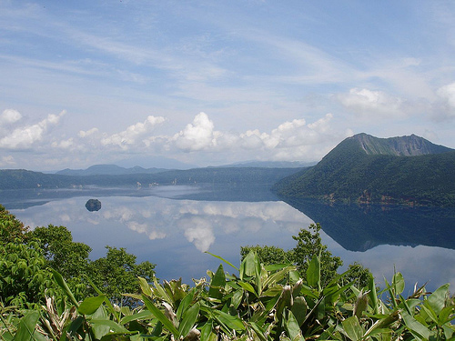
Lake Mashu (19 km²): One of the world’s
clearest lakes (visibility up to 40 m), with striking deep-blue waters,
steep crater walls rising hundreds of meters, and no inflowing
rivers—fed only by rain and snowmelt. It reaches depths of 212 m and is
often shrouded in mist.
Smaller lakes include Onneto (“lake of
seven colors,” known for shifting hues due to minerals and light), Taro
and Jiro (formed by Mount Oakan eruptions), Panketo, Penketo, and
others. Rivers such as the Akan River connect some lakes, while hot
springs and geothermal outflows are abundant (e.g., Kawayu Onsen, Meakan
Onsen).
Climate, Vegetation, and Ecosystems
Hokkaido’s
subarctic climate brings cold winters with heavy snowfall, cool summers,
and high humidity. Volcanic soils and elevation create microclimates:
dense forests at lower elevations transition to alpine meadows and
barren craters higher up.
Much of the park is covered in primeval
subarctic mixed forests—among Japan’s most pristine—dominated by
Sakhalin spruce, Sakhalin fir, Yezo spruce, Erman’s birch, and
broad-leaved trees like katsura. Mosses, ferns, and mushrooms thrive in
the understory. Above the tree line, hardy species like Japanese stone
pine and marsh Labrador tea colonize acidic volcanic soils. Autumn
foliage is spectacular, with fiery reds and oranges contrasting against
evergreens and lakes.
Overall Landscape Character
Akan-Mashu
National Park presents a mosaic of nested calderas, steaming volcanoes,
mirror-like lakes, and ancient forests in a compact area. The interplay
of active geology, clear waters, and dense vegetation creates a dynamic,
otherworldly wilderness that feels both ancient and alive. Geothermal
warmth supports unique micro-ecosystems (e.g., year-round warm ground on
Wakoto Peninsula), while the isolation preserves biodiversity in one of
Hokkaido’s most intact natural areas.
This volcanic heartland
continues to evolve through ongoing tectonic and eruptive processes,
offering visitors a window into the powerful forces that have sculpted
northern Japan’s geography for millennia.
Akan-Mashu National Park (also known as Akan National Park;
officially renamed Akan-Mashu in recent years) is a 91,413-hectare
protected area in eastern Hokkaido, Japan, encompassing three major
caldera lakes—Lake Akan, Lake Kussharo, and Lake Mashu—along with active
volcanoes (such as Mount Meakan, Mount Oakan, and Mount
Io/Atosa-Nupuri), vast primeval forests, wetlands, and hot springs.
Designated as one of Japan’s earliest national parks in 1934, it
represents a subarctic to cool-temperate ecosystem shaped by volcanic
activity, where forests, lakes, and alpine zones support high
biodiversity. The park’s flora and fauna reflect Hokkaido’s northern
character, with many species adapted to volcanic soils, cold winters,
and pristine waters. It is also a cultural homeland for the Ainu people,
who have long coexisted with and revered this nature (e.g., bears as
mountain spirits).
Flora: Forests, Alpine Plants, and Unique
Aquatic Life
The park’s vegetation is dominated by primeval mixed
forests that transition from coniferous to broad-leaved species
depending on elevation and soil. At lower elevations around the bases of
Mount Meakan and Mount Oakan, you’ll find Sakhalin fir (Abies
sachalinensis), Yezo spruce (Picea jezoensis), Sakhalin spruce (Picea
glehnii), Erman’s birch (Betula ermanii), katsura (Cercidiphyllum
japonicum), and Mongolian oak (Quercus mongolica). Some oaks and Judas
trees exceed 300–800 years old. These forests create dense canopies that
support rich understories, with roughly 700 species of higher plants
overall, shifting from forest-floor herbs to alpine flora at higher
elevations.
Around volcanic features like the sulfuric Mount Io
(Atosa-Nupuri), hardy plants thrive in rocky, gas-rich soils where
others cannot. Labrador tea (Ledum palustre var. diversipilosum), a
rhododendron relative, grows abundantly here; its white flowers bloom
profusely from June to July amid fumaroles. Alpine specialists include
the rare Meakan-kinbai (Potentilla miyabei Makino), an endangered
endemic Hokkaido plant first discovered on Mount Meakan. It produces
bright yellow, plum-like flowers in August on sun-exposed slopes. Other
notables are white azalea (isotsutsuji), Primula jesoana, soft
windflower, corydalis ambigua (a spring ephemeral), white skunk cabbage
(blooming April–May), and the giant rawanbuki butterbur (up to 2–3 m
tall along rivers).
The park’s most iconic flora is the marimo
(Aegagropila linnaei), a freshwater green alga unique to Lake Akan.
These form near-perfect spherical balls—up to 30 cm in diameter, the
largest in the world—due to a precise balance of sunlight, clean water,
wind-driven waves, and gentle rolling on the lakebed. Lake Akan is one
of only two global sites with such large marimo; they are designated a
National Special Natural Monument. The lake hosts 259 freshwater algae
species total. Marimo face threats from warming waters and environmental
changes, but they remain a symbol of the park’s pristine aquatic
ecosystems.
Wetlands, marshes (e.g., Hyotan Marsh), and river systems
add further diversity, including indicator species like the freshwater
pearl mussel in clean tributaries.
Fauna: Mammals, Birds, Fish,
and More
The park supports robust populations of mammals, with 24
species across 9 families in the Akan caldera area alone. Large mammals
dominate the forests and plains.
Mammals include:
Yezo/Ezo
sika deer (Cervus nippon yesoensis): Among Japan’s largest, with stags
over 200 kg and antlers exceeding 90 cm. They are abundant, foraging
nocturnally in forests.
Brown bears (Ursus arctos): Japan’s largest
land animal; they inhabit coniferous forests and are culturally
significant.
Ezo red fox (Vulpes vulpes schrencki): Common and larger
than Honshu counterparts; often seen near human areas but wild.
Japanese sable (Martes zibellina brachyura): Agile climbers in forests,
marshes, and rivers; does not hibernate.
Others: Siberian flying
squirrel, Yezo (red) squirrel (active year-round), and raccoon dogs.
Birds number around 150 species, making the park a paradise for
avian watchers. Coniferous forests host small songbirds like goldcrests,
coal tits, Ural owls, striped long-tailed tits (“snow fairies”), and
woodpeckers—including the black woodpecker (Japan’s largest, a natural
monument) and great spotted/Ezo white-backed woodpeckers. Lakes and
reservoirs attract large grey herons, various ducks, and migratory
waterfowl. In winter, whooper swans gather on Lake Kussharo, while
white-tailed eagles and Steller’s sea eagles (one of the world’s
largest, vulnerable) patrol lakes and rivers. The rare, endangered
Blakiston’s fish owl (Japan’s largest owl, with 1.8 m wingspan; Ainu
name “Kotankor Kamuy,” village-protecting spirit) hunts fish in rivers
and is a highlight for birders. Other notables include the Yezo crested
kingfisher and Latham’s snipe.
Aquatic life thrives in the lakes.
Native fish include the beautiful golden white-spotted char (some over
80 cm), kokanee (landlocked sockeye salmon, called “Cippu” locally, with
red flesh), Sakhalin taimen (Japan’s largest freshwater fish, exceeding
1 m), rainbow trout, masu salmon, pond smelt (popular for ice fishing),
and carp. These support the food web for birds and mammals.
Volcanic
features like “bokke” (boiling mud pools) on lake shores provide winter
refuges for animals seeking warmth and insects. The overall ecosystem is
interconnected: volcanic activity enriches soils and creates unique
microhabitats, while the lakes and forests sustain a balanced web of
life. Conservation is active, with protections for marimo, endangered
plants like Meakan-kinbai, and species like Blakiston’s fish owl.