Location: 60 km East of Aqaba Map
Area: 75,000 ha
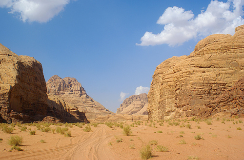
Wadi Rum Protected Area, often called the Valley of the Moon (Wadi
al-Qamar in Arabic), is one of Jordan's most iconic natural and cultural
treasures. Located in southern Jordan about 60 km east of Aqaba near the
Saudi border, it spans roughly 720 km² of dramatic desert landscape. The
area was inscribed as a mixed UNESCO World Heritage Site in 2011 under
criteria (iii), (v), and (vii) for its exceptional testimony to 12,000
years of human-environment interaction, continuity of pastoral and
nomadic lifestyles, and spectacular desert scenery featuring sandstone
mountains, narrow gorges, natural arches, towering cliffs, massive
landslides, caverns, and intricate honeycomb weathering patterns.
The
landscape results from millions of years of tectonic uplift, faulting,
and erosion by wind, water, and salt in shifting climates (from humid to
arid). Tall, near-vertical mountains of iron-rich Umm Ishrin Sandstone
(Paleozoic era, ~500 million years old) sit atop ancient Precambrian
granitoids, creating a striking red-orange palette against flat valleys
of sand, alluvial sediments, and salt pans. Elevations range from about
45 m in the wadis to Jordan’s highest peak, Jabal Umm ad Dami (~1,854
m), with Jebel Rum at 1,734 m offering panoramic views.
Wadi Rum’s
fame also stems from its human history and T.E. Lawrence (“Lawrence of
Arabia”), who documented the area during the 1917–18 Arab Revolt. The
Zalabieh Bedouin community still lives here, preserving traditional
nomadic culture amid modern tourism. It has served as a filming location
for movies like Lawrence of Arabia, The Martian, Dune, and Star Wars
episodes due to its otherworldly terrain.
1. Seven Pillars of Wisdom (Jabal al-Mazmar)
This is the most
iconic and photogenic rock formation in Wadi Rum, visible for miles as
you approach from the visitor center. It consists of seven (or five
prominently visible from the main viewpoint) towering, fluted sandstone
pillars that lean against each other like a monumental natural
sculpture. The formation exposes the area’s geology: quartz-rich
sandstone over much older granitoids.
Named after T.E. Lawrence’s
1926 book Seven Pillars of Wisdom (though the book doesn’t directly
reference this exact site), its original Arabic name is less romantic. A
short, easy walk from the visitor center leads to excellent viewpoints.
It exemplifies the scale and beauty of Wadi Rum’s sandstone cliffs and
serves as the perfect introduction to the protected area’s aesthetic
values.
2. Lawrence’s Spring (Ain Shalaaleh or Ain Abu Aineh)
A true desert oasis, this natural spring emerges from the rock face with
a shaded pool, lush ferns, grasses, and fig trees—an unexpected burst of
green amid the red sands. Ancient Nabataean inscriptions and petroglyphs
adorn nearby rocks. T.E. Lawrence and his forces used it as a watering
stop for camels during the Arab Revolt; he vividly described it in his
writings.
A short but steep scramble (about 15–30 minutes) from the
track behind Wadi Rum village’s cemetery reaches it. It highlights the
area’s water catchment systems, vital for 12,000 years of human
habitation, and offers peaceful views across the valley.
3.
Khazali Canyon (Siq al-Khazali or Jebel Khazali)
One of the most
culturally and geologically fascinating stops, this narrow fissure
slices deep into Jebel Khazali mountain. Smooth basins and erosion
patterns from millennia of flash floods create a dramatic slot canyon.
The walls are covered in thousands of petroglyphs and
inscriptions—camels, horses, ibex, ostriches, human figures, footprints,
hunting scenes, and Thamudic/Nabataean scripts dating back 2,000–2,800
years (some sites in the broader area reach 12,000 years old).
Hand-carved water pools add to its intrigue.
A short, easy walk
enters the canyon; a steeper, slippery climb reaches upper sections
(often skipped on standard tours). It provides exceptional testimony to
ancient literacy and pastoral life in the desert.
4. Natural Rock
Bridges and Arches
Wadi Rum boasts several spectacular natural arches
formed by erosion. The most famous include:
Burdah Rock Bridge
(highest in Wadi Rum): Perched on Jabal Burdah at ~1,350 m elevation,
this 35 m tall by 20 m wide arch is one of the world’s most elevated
natural bridges. The strenuous 260 m scramble/rock climb (2–3 hours
round-trip) rewards with breathtaking 360° panoramas over the desert.
Little Bridge (or Um Fruth Rock Bridge): Smaller and more accessible,
this photogenic arch sits at a valley intersection. It’s easily climbed
for panoramic views and is a staple on jeep tours. The surrounding red
sand and cliffs make it highly scenic.
Other arches like the Double
Bridge in the southern yellow-sand areas exist for more adventurous
explorers.
5. Lawrence’s House
Little remains of this site
except a ruined wall of carved blocks atop a Nabataean water cistern,
where Lawrence reportedly rested during the Revolt. The real draw is the
dramatic scenery: towering cliffs, a field of Bedouin cairns (stacked
rock markers for safe routes), and sweeping valley views if you hike
partway up the nearby slope.
6. Red Sand Dunes (Al Ramal / Al
Hasany Dune)
Vibrant orange-red sand dunes pile dramatically against
mountains like Jebel Umm Ulaydiyya. Climbing to the crest offers
soft-sand contrasts with rugged cliffs and distant views (including
Khazali Canyon and bridges). Perfect for sunset watching, sandboarding,
or simply experiencing the desert’s vastness.
7. Other Notable
Features
Mushroom Rock / Cow Rock: Solitary wind-eroded formations
resembling giant mushrooms or animals—highly photogenic examples of
tafoni and honeycomb weathering.
Anfishiyyeh Inscriptions: Massive
rock walls with detailed Thamudic/Nabataean camel carvings, hunting
scenes, and symbols (2,500–2,800 years old).
Canyons like Barrah or
Abu Khashaba: Longer hikes through colorful cliffs, sand, and vegetation
for those seeking deeper exploration.
Nabataean Temple ruins near the
village and Jabal Rum massif for serious hikers/climbers.
Best Time to Visit
Spring (March–May) and Autumn
(September–November): Ideal periods with pleasant daytime temperatures
(around 20–30°C/68–86°F), cooler nights, clear skies, and wildflowers in
spring. These are peak seasons, so book ahead.
Winter
(December–February): Fewer crowds and lower prices, but cold nights (can
drop near or below freezing) and occasional rain/snow at higher
elevations. Good for stargazing.
Summer (June–August): Very hot days
(often >40°C/104°F), fewer visitors. Tours run early morning or late
afternoon to avoid peak heat.
Aim for shoulder periods like late
February or November for a balance of weather and crowds.
How to
Get There
Wadi Rum is accessible but remote:
From Aqaba: ~1–1.5
hours (70 km). JETT bus (~15 JOD), taxi (25–35 JOD), or rental car.
From Petra (Wadi Musa): ~1.5–2 hours (110 km). JETT bus or private
transfer (35–45 JOD).
From Amman/Dead Sea: ~4–5 hours. JETT bus or
private driver.
Most visitors arrive at the Wadi Rum Visitor
Centre (7 km north of Wadi Rum Village). Park there or in the village
(free/safe parking reported by many). Private vehicles (even 4WD
rentals) generally cannot enter the protected area
independently—transfer to a Bedouin 4x4 is required.
Jordan Pass (70
JOD) covers the ~5 JOD entrance fee to Wadi Rum Protected Area plus many
other sites and often the visa—highly recommended for most travelers.
Entry and Logistics
Register at the Visitor Centre. Your camp or
guide will usually meet you there for the 4x4 transfer into the desert
(included in most bookings). Bring cash (JOD preferred)—few/no ATMs
inside.
How to Explore: Activities and Tours
Jeep (4x4) tours
are the most popular and efficient way to see highlights: Lawrence’s
Spring (Ain Ash Shallalah), red sand dunes, Khazali Canyon (with ancient
inscriptions), rock bridges (e.g., Umm Fruth, Burdah), canyons, and
sunset viewpoints. Half-day (~2–4 hours) or full-day options are common.
Camel rides/treks: More traditional and relaxed, great for
sunrise/sunset or short overnights. Slower than jeeps.
Hiking and
scrambling: Options range from easy canyon walks (e.g., Makharas,
Barrah) to challenging climbs (Jebel Rum, Jebel Burdah). Guides are
strongly advised for longer routes.
Stargazing and hot air balloon:
One of the world’s best dark-sky spots (especially July–September for
Perseids). Optional balloon rides at sunrise.
Other: Sandboarding,
rock climbing (with qualified guides), cultural experiences with Bedouin
hosts (tea, stories, traditional meals like zarb—underground barbecue).
Minimum stay: One night for sunset/sunrise/stargazing. Two+ nights
recommended for deeper immersion. Day trips are possible but rushed.
Booking tips: Arrange through reputable camps or operators (many offer
packages including transport, meals, and tours). Avoid suspiciously
cheap "deals" on Booking.com—hidden fees for transport/food are common,
and fake reviews exist. Packages via GetYourGuide or direct with trusted
Bedouin operators work well.
Where to Stay: Desert Camps
Overnighting in a Bedouin camp is essential for the full experience.
Options range from basic goat-hair tents (shared facilities) to luxury
bubble domes or insulated tents with en-suite bathrooms and AC/heating.
Most include meals and transport; smaller/mid-size camps often feel more
authentic.
Popular/recommended styles:
Authentic Bedouin (e.g.,
Arabian Nights, traditional tents).
Luxury/glamping (bubbles, domes
with views).
Cave camping for something unique.
Book in
advance for peak seasons. Solar power means limited electricity; hot
water and Wi-Fi are not guaranteed.
What to Pack and Practical
Tips
Clothing: Modest, lightweight, breathable layers (cover
shoulders/knees for cultural respect). Warm jacket/fleece for nights.
Scarf/keffiyeh for sun/dust. Comfortable hiking shoes with good grip.
Essentials: Sunscreen (high SPF), hat, sunglasses, lip balm, reusable
water bottle (stay hydrated—desert air dehydrates quickly),
headlamp/flashlight, power bank, snacks, wet wipes/hand sanitizer.
Other: Personal medications, cash, binoculars/camera for
stargazing/landscapes. Bug spray for evenings.
Health/Safety:
Jordan is generally very safe. Desert hazards include heat, cold, sand,
and uneven terrain. Follow your guide, don’t wander alone at night, and
respect wildlife. No major crime issues reported in tourist areas.
Cultural Etiquette:
Dress modestly.
Greet with “Salam
Alaikum”; accept tea/hospitality graciously (refuse politely if needed).
Women: Avoid prolonged eye contact with strangers if solo.
Photography: Ask permission for people; no drones without permits.
Ramadan: Adjust expectations for meals/timing if visiting then.
Common Mistakes to Avoid:
Underestimating temperature swings.
Rushing with only a day trip.
Booking unverified cheap camps without
clarifying inclusions.
Not bringing enough cash or sun protection.
Geological Backdrop
The dramatic scenery of Wadi Rum formed
through a series of ancient processes. Over a billion years ago, a
granite base formed, followed by massive quartz sandstone deposits from
rivers during the Cambrian period around 500 million years ago. Tectonic
uplift raised these layers high above sea level, while wind, sand
erosion, salt weathering, and water action sculpted the iconic mesas,
canyons, and dunes. Springs and aquifers in the sandstone have long
provided vital water in this arid environment, enabling human presence
despite the harsh conditions.
Etymology and Early Associations
The name "Wadi Rum" (or "Rumm") has several proposed origins. One links
it to the Aramaic word for "high" or "elevated," referring to the
towering rock formations ("valley of the high places"). Another theory
connects it to the Quranic "Iram of the Pillars" (Iram dhat al-Imad), a
legendary lost city of the 'Ad people mentioned in the Quran, whose
lofty pillars some interpret as matching Wadi Rum's sandstone columns. A
third suggests "Rum" derives from "Romans" or "Byzantines" (Rūm in
Arabic), possibly referring to Christian communities or monks who sought
refuge here. Bedouin traditions and inscriptions reinforce these
cultural layers.
Prehistoric and Protohistoric Human Occupation
(c. 12,000 years ago onward)
Humans have inhabited Wadi Rum since at
least the late Paleolithic/Epipalaeolithic period (around 12,000 years
ago), likely as part of early migratory routes out of Africa. Over
25,000 petroglyphs (rock carvings) and 20,000 inscriptions have been
documented, making it one of the world's richest open-air libraries of
ancient human activity. These span from the Neolithic through later
periods and depict a shift from hunter-gatherer life to pastoralism and
trade.
Early art styles: The oldest engravings and rare paintings
(often in concealed caves or under overhangs, using red haematite and
black pigments) show large bovines (aurochs), ibex with sweeping horns,
gazelles, deer, ostriches, and hunting scenes. Superimpositions and
patina analysis help date them—darker, oxidized images are older.
Paintings in sites like GG Cave and Rizga Cave reveal multi-layered use
over millennia, enhanced by modern imaging techniques like DStretch.
Thamudic, Hismaic, and other scripts: Nomadic groups (Thamud, Hismaic
speakers) left inscriptions in North Arabian scripts from roughly the
1st millennium BCE onward. These include prayers to gods, tribal marks,
caravan routes, water sources, humans in warrior or dancing poses,
camels, horses, and footprints. They reflect high literacy among
pastoral societies and the evolution of alphabetic writing.
Recent research (2022–2023 expeditions) has uncovered pre-Nabataean
paintings and longer timelines, linking art to climate shifts: greener
early Holocene environments gave way to aridity around 4,000 years ago,
with domesticated camels appearing later.
A landmark 2025 discovery
added an even earlier layer: the first royal Egyptian hieroglyphic
inscription in Jordan—two cartouches of Pharaoh Ramesses III (c.
1186–1155 BCE)—on a rock face in the reserve. This points to Egyptian
military or commercial campaigns along trade corridors linking the Nile
to the Levant and Arabia.
Ancient Civilizations: Edom,
Nabataeans, and Romans (c. 13th century BCE–4th century CE)
Wadi Rum
lay along key incense and trade routes connecting Arabia, the Red Sea
(near modern Aqaba/Ayla), Petra, and the Levant. It was likely part of
the Iron Age Kingdom of Edom (13th–6th centuries BCE), with nearby
copper mines at Wadi Feynan and fortifications.
The Nabataeans (an
Arab nomadic tribe who rose to prominence c. 4th century BCE–106 CE)
left the most prominent marks. They mastered desert hydrology, building
cisterns, dams, aqueducts, and temples. Key sites include:
The
Nabataean Temple (near the modern Rest House/visitor area), dedicated to
the goddess Allat (late 1st century BCE/early 1st century CE), later
used by Romans (with Latin and Greek inscriptions).
Ain Shallaleh
(Lawrence’s Spring), a natural spring with Nabataean inscriptions,
betyls (sacred stone representations of deities like Al-Uzza and
Al-Kutba), and water channels. Lawrence vividly described its "paradise"
of ferns and flowing water.
Petroglyphs from this era often mark
routes and water sources, showing ibex, camels, and human figures with
Greek/Persian/Roman stylistic influences. After Roman annexation in 106
CE, the area remained a trade outpost.
Byzantine, Early Islamic,
and Bedouin Eras (c. 4th–19th centuries CE)
During the Byzantine
period, Wadi Rum served as a refuge for Christian hermits and monks
fleeing persecution. Some link the name "Rum" to these "Roman/Byzantine"
Christians. Early Islamic inscriptions (including Quranic verses) and
Bedouin "wasim" tribal marks appear on rocks.
From the 5th–7th
centuries onward, Bedouin tribes (including ancestors of today's
Zalabieh and Howeitat) dominated as nomadic pastoralists. They
maintained traditional lifestyles tied to camels, trade, and seasonal
movement. The Umayyad conquest (7th century) integrated the area into
Islamic caliphates, followed by later empires.
The Arab Revolt
and T.E. Lawrence (1916–1918)
Wadi Rum gained international fame
through British officer T.E. Lawrence ("Lawrence of Arabia") during
World War I. As a liaison to the Arab Revolt against Ottoman rule,
Lawrence used the valley as a strategic base and hideout with Prince
Faisal's forces and local Bedouin allies. Its remoteness, water sources,
and defensible terrain made it ideal for guerrilla operations.
Key sites include:
Lawrence’s Spring (Ain Shallaleh or nearby) and
Ain Shalaleh — vital for men and camels.
Lawrence’s House — a
rock-carved shelter used as a headquarters.
Seven Pillars of Wisdom —
a rock formation (originally Jabal al-Mazmar) later named after
Lawrence’s memoir Seven Pillars of Wisdom (the book’s title actually
references Proverbs, not this site).
Lawrence described entering
the valley in poetic terms: towering red ramparts like "Byzantine
architecture" and the spring as a lush oasis amid inscriptions.
Operations here supported the capture of Aqaba (Battle of Aqaba, 1917)
and broader campaigns. The 1962 film Lawrence of Arabia later filmed
scenes here, boosting global awareness.
Modern History:
Settlement, Protection, and Tourism (20th–21st centuries)
The
Zalabieh Bedouins (primarily from Hijaz origins) settled more
permanently in the mid-20th century; the modern village was built in the
1970s–1980s, initially with tents and now mixed housing (population
~700–800). Many transitioned from nomadic herding to tourism guiding,
preserving camel culture and traditions.
The Wadi Rum Protected Area
was established in 1997 (expanded 2002) under the Royal Society for the
Conservation of Nature and Jordan’s Department of Antiquities. It became
a UNESCO World Heritage Site in 2011 as a mixed cultural-natural
property (criteria iii, v, vii): for its testimony to 12,000 years of
human-environment interaction, evolving land-use patterns, and
exceptional desert aesthetics.
Today, Wadi Rum blends conservation
with sustainable tourism—jeep tours, camel treks, hiking, and
stargazing—while protecting rock art and sites. It remains home to
Bedouin communities who embody the region’s living cultural heritage.
Wadi Rum (Arabic: وادي رم, also known as the Valley of the Moon or
Wadi al-Qamar) is one of the world's most iconic desert landscapes, a
vast valley carved into sandstone and granite in southern Jordan.
Located within the Hisma Desert on a high plateau east of the Jordan
Rift Valley and south of the central Jordanian plateau, it lies
approximately 60 km (37 mi) east of the coastal city of Aqaba and near
the Saudi Arabian border. The Wadi Rum Protected Area covers about 742
km² (74,200 hectares, or roughly 721 km² in some measurements), making
it Jordan's largest wadi (dry river valley). It extends roughly 42 km
north-south and 33 km east-west, with a surrounding buffer zone of about
60,000 ha. Elevations range from around 900–1,000 m (valley floor and
village of Rum at ~952 m) to a maximum of 1,750–1,840 m, with Jordan's
highest peak, Jabal Umm ad Dami (~1,840 m / 6,040 ft), situated in the
south near the Saudi border.
The landscape is defined by
dramatic, near-vertical inselbergs (isolated mountains) of iron-rich
sandstone rising sharply from broad, flat-bottomed valleys floored with
pink-to-red aeolian sands, alluvial sediments, and occasional salt pans
(sabkhas or mudflats). Prevailing northwesterly winds sweep the valleys
clean, creating a mosaic of colors—from deep red-orange iron-oxide hues
in the northwest ("red desert") to lighter, softer sandstones in the
southeast ("white desert"). Parallel north-south fault lines control
many of the valleys, producing a grid-like pattern of corridors and
massifs.
Topography and Major Landforms
Wadi Rum's topography
is a textbook example of desert geomorphology shaped by differential
erosion. Towering cliffs and pyramidal massifs dominate, often exceeding
700 m in height above the valley floor. Key features include:
Sandstone Mountains and Cliffs: The most prominent are formed from the
thick Umm Ishrin Sandstone, which weathers into steep, striated walls
with dramatic vertical joints and faults.
Narrow Gorges and Canyons:
These include siqs (slot canyons) and deeper incisions like Khazali
Canyon, whose steep walls shelter ancient Thamudic petroglyphs and offer
dramatic enclosed vistas.
Natural Arches, Bridges, and Cavernous
Forms: Wind and water erosion have sculpted numerous natural arches
(e.g., Burdah Arch/Little Bridge) and mushroom-shaped rocks. The area
boasts some of the world's most spectacular networks of honeycomb
(tafoni) weathering—cavernous, pitted surfaces created by salt
crystallization and other processes.
Sand Dunes and Aeolian Features:
Barchan (crescent) dunes, climbing dunes (sand ramps that ascend
cliffs), and echo dunes (deposited on the lee sides of hills) are
prominent. Alluvial fans spread out at mountain bases where rare flash
floods deposit sediment.
Iconic Landmarks: The Seven Pillars of
Wisdom (a massive, multi-fingered sandstone outcrop named after T.E.
Lawrence's book), Jebel Rum (second-highest peak in Jordan at
~1,734–1,754 m, dominating the central valley opposite Jebel um Ishrin),
and expansive sandy plains that evoke a "Martian" red landscape (as used
in films like The Martian).
Geological Formation and Rock Types
Geologically, Wadi Rum represents a Pre-Cambrian peneplain (an ancient,
eroded surface) exposed and uplifted over millions of years. The
basement consists of Precambrian granitoid plutonic rocks from the Aqaba
Complex (over 1 billion years old). These are unconformably overlain by
a thick sequence (~850 m exposed) of continental Nubian Sandstones
deposited in shallow seas during the Lower Cambrian to Middle Ordovician
(~540–470 million years ago). The dominant unit is the iron-rich Umm
Ishrin Sandstone, underlain by the Salib Arkosic Formation and overlain
by Disi and Umm Sahn formations. Quaternary sediments (alluvial fans,
dunes, and mudflats) cap the sequence.
The modern landscape formed
primarily during the Miocene-Pliocene (25–5 million years ago) through
tectonic uplift and faulting associated with the opening of the Jordan
(Dead Sea) Rift Valley. Rapid uplift, jointing, and faulting exposed the
rocks, while ongoing processes—fluvial incision (in past wetter
climates), wind abrasion, salt weathering, biological activity, and
undermining of cliffs—created the current spectacular forms: narrow
gorges, arches, landslides, ramps, and tafoni. The red coloration comes
from iron oxide in the sandstones.
Climate
Wadi Rum has a hot
desert climate (Köppen BWh/BWk), extremely arid with fewer than three
rainy days per year on average. Annual precipitation is low (~50–100 mm,
or 74 mm at the village station from 1971–2000 data), mostly falling in
winter as intense thunderstorms that trigger flash floods. Summers are
scorching (daytime highs averaging 34–35°C in July, extremes to 45°C),
with lows around 19°C; winters are milder (daytime ~15°C in January,
nighttime ~4–5°C, occasionally below freezing). Relative humidity drops
to ~26% in summer. Prevailing northwesterly winds shape dunes and erode
surfaces, while clear skies and low light pollution make it exceptional
for stargazing.
Hydrology and Water Features
Surface water is
scarce and ephemeral. Rare rains produce flash floods that carve canyons
and deposit alluvium. Groundwater is mostly non-renewable fossil water
in aquifers, particularly along the contact between the granite basement
and overlying sandstones, where springs emerge (notably Ain Shalaaleh /
Lawrence's Spring at the base of Jebel Rum—a small, fern-fringed pool
fed by a fissure). Groundwater levels have declined in recent decades
due to regional extraction and climate trends. Salt pans form in
low-lying valley floors where evaporation concentrates minerals.
Ecological Aspects
Soils are thin and sandy in valleys (alluvial and
aeolian), with sparse vegetation adapted to extreme aridity. Sand-dune
communities (covering much of the site) feature drought-resistant shrubs
like Haloxylon persicum (a key sand-fixer and camel fodder), Retama
raetam, Calligonum comosum, and Hammada scoparia. Springs support
localized lush patches of ferns and grasses. Fauna includes
desert-adapted species (camels, historically gazelles and ibex), with
the site lying along a major migratory bird flyway.
Inscribed as a
UNESCO World Heritage Site in 2011 (mixed cultural-natural criteria,
including vii for its "iconic desert landscape" and spectacular
landforms), Wadi Rum's geography represents millions of years of Earth
processes in a protected, accessible setting—often described as one of
nature's ultimate achievements.
Despite its arid climate, Wadi Rum supports a fragile ecosystem
adapted to extreme conditions:
Flora: Sparse vegetation includes
drought-resistant plants like acacia trees, tamarisk shrubs, and desert
grasses. Spring rains briefly transform parts of the valley with
wildflowers and green patches.
Fauna: Wildlife includes Arabian oryx
(reintroduced after near-extinction), ibex, desert foxes, sand cats, and
various reptiles like agama lizards and vipers. Birds such as vultures,
eagles, and migratory species pass through.
Water Sources: Natural
springs and seasonal water pools (gueltas) sustain life, though water is
scarce. Bedouin knowledge of these sources has been critical for
survival.
The area’s designation as a protected area since 1998 aims
to preserve its biodiversity and prevent overdevelopment, though tourism
poses challenges like litter and habitat disruption.