Location: Baniyas, Tartus Governorate Map
Constructed: 1062
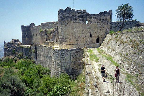
Margat Castle (also known as Marqab, Marqab Castle, or Qal'at al-Marqab, Arabic for "Castle of the Watchtower") is one of the largest and most impressive Crusader fortresses in the Levant. Located on a volcanic hill spur of the Jebel al-Ansariye mountains near Baniyas in Syria's Tartus Governorate, about 2 km from the Mediterranean coast and roughly 360 meters above sea level, it overlooks the vital coastal road between Tripoli and Latakia. Built primarily of dark basalt stone, the castle spans a vast area (over 15 hectares in its Hospitaller form) and exemplifies the pinnacle of medieval military architecture as a concentric "fighting machine."
Early History (1062–1186): From Muslim Outpost to Crusader Fief
The site was first fortified around 1062 by local Muslim tribes or a
landlord (possibly linked to the Emirate of Homs or Aleppo vassals) to
control the Syrian coastal region. Arab sources confirm this early
construction. After the First Crusade (1096–1099), the castle remained
in Muslim hands even within the newly established Christian Principality
of Antioch.
Following the Principality's defeat at the Battle of
Harran in 1104, the Byzantine Empire exploited the weakness and seized
Margat from the Muslims under Admiral Kantakuzenos. A few years later
(around 1116–1118), it was captured by Tancred, Prince of Galilee and
regent of Antioch, or granted as a fief by Roger of Salerno (regent of
Antioch) to the noble Reynald (or Rainald) Mazoir, a prominent
Antiochene family. It became part of the Principality of Antioch but
served as a border fortress protecting against the County of Tripoli.
The Mazoir family (notably Reynald II Masoir in the 1170s) held it as a
major fief, large enough to support its own household officials and
rear-vassals. Earthquakes in 1157, 1170, and 1186 caused significant
damage, straining resources. In 1133 it briefly fell to Muslim forces
before being regained around 1140. By the late 12th century, maintenance
costs became unsustainable, leading Bertrand Mazoir to sell the castle
to the Knights Hospitaller (Order of Saint John) in 1186.
Hospitaller Era (1186–1285): Peak Power and Impregnability
The
Hospitallers— one of the most powerful military-religious orders in
medieval Europe—transformed Margat into their primary headquarters in
Syria (second only to Krak des Chevaliers). Between 1186 and 1205, they
undertook massive rebuilding and expansion, creating a concentric castle
with double curtain walls (15 feet thick in places), an outer ward, 14
towers, a prominent circular tower (sometimes called a donjon, though
not central), a massive keep behind it, a church, great hall, barracks,
offices, and rock-cut cisterns/vaults for water storage. The layout was
roughly triangular or ship-shaped, with one side protected by a deep
natural ravine (requiring only a single wall) and the others heavily
fortified with converging walls and a bent entrance for defense.
Strategically positioned, it controlled roads, tolls from travelers and
pilgrims, and surrounding lands. The bishop of nearby Valenia (Baniyas)
used it as headquarters from around 1240. It even served as a prison for
high-profile captives, such as Isaac Comnenus of Cyprus (seized by
Richard I of England during the Third Crusade).
Notable visitors
included King Andrew II of Hungary during the Fifth Crusade (1217–1218),
who stayed at the castle and endowed the Hospitallers with a generous
annuity for its upkeep. (Some older accounts mistakenly link it to
Richard the Lionheart, but no evidence supports a 1218 visit by him.)
Key sieges it withstood:
1188: After the Battle of Hattin and the
fall of Jerusalem, Saladin marched on Margat but deemed its defenses
impregnable and bypassed it (moving instead to Jabala and other sites).
It remained one of the few Christian strongholds in the region.
1206:
Ayyubid forces attempted a siege but were repulsed.
Multiple attempts
by Mamluk Sultan Baibars (1269–1281), including after his conquest of
Krak des Chevaliers in 1271; all failed.
In 1281, Hospitallers
from Margat supported a Mongol invasion of Syria, contributing to Mamluk
Sultan Qalawun's decision to target it.
The Fall: Mamluk Siege of
1285
The castle's end as a Crusader stronghold came during a 38-day
siege starting 17 April 1285. Sultan Al-Mansur Qalawun led a large
Mamluk army equipped with trebuchets and sappers. Initial assaults on
the converging tower were repelled, but miners tunneled under the
southern wall, collapsing a salient. Defenders, upon inspecting the
damage (at Qalawun's invitation), realized resistance was futile. On 23
May 1285, they surrendered in exchange for safe conduct to Tortosa
(Tartus). Qalawun entered two days later.
Unlike many fortresses he
razed, Qalawun repaired Margat and installed a strong garrison due to
its strategic coastal value. It served as a base for the later conquest
of Tripoli in 1289. The siege was eyewitnessed by the young Abu'l Fida
(future Ayyubid historian) and his father.
Post-Crusader History:
Mamluk, Ottoman, and Modern Periods
Under the Mamluks, Margat (known
as Marqab) became an administrative district in the province of Tripoli.
It functioned for coastal defense against threats from Cyprus, with
guard towers and observation posts. Later, during the Burji Mamluk era,
it housed an imperial prison for high-profile detainees. 15th-century
historian Khalil al-Zahiri described it as "clearly impregnable" and
vital to the province.
In the Ottoman period, it served as the center
of the kaza (district) of Margat, encompassing subdistricts like Qadmus
and Khawabi. By the 1890s, the district had dozens of villages and a
mixed population (including many Alawites), with an economy based on
olives, tobacco, silk, and onions. The fortress housed the kaymakam
(governor) until 1884, when administration moved to Baniyas. It was
later occupied by Ottoman and Turkish soldiers into the early 20th
century.
The site fell into ruin through neglect but has seen limited
archaeological work, including Syrian-Hungarian missions exploring its
medieval layers. It remains owned by the Al-Markabi family (from whom
the name derives). Renovations began around 2007, and it is open to the
public as a historic ruin, though damaged by the 2023 earthquake.
Materials and Construction Techniques
The castle is almost
entirely constructed from local black basalt—a dark, volcanic stone
quarried directly from the site, including from rock-cut cisterns
excavated beneath the buildings. This gives Margat its distinctive
"Black Fortress" appearance and nickname. Basalt provided exceptional
durability and strength, with walls reaching thicknesses of 4.5–6 meters
(inner walls historically described as about 15 feet or 4.5 m thick).
Decorative accents occasionally incorporate lighter limestone for
contrast, a regional practice seen in other Syrian structures. The
stonework is massive and functional, with vaults, arches, and
foundations hewn directly from the bedrock for added stability. Much of
the visible fabric dates to the major Hospitaller rebuilding phase after
1186, though earlier Islamic and Byzantine elements influenced the
foundations.
Overall Layout and Shape
Margat follows a
triangular spur castle design that hugs the contours of the extinct
volcanic hilltop (roughly half a mile or 800 meters in circumference).
One long side is naturally protected by a steep ravine or cliff,
requiring only a single wall. The other two sides feature double
concentric curtain walls that converge at the southern tip, creating
layered defenses. The fortress divides into two main zones:
A
large outer ward/enclosure (northern section, less heavily fortified but
still walled) used for farming, livestock, and a castletown/suburb
supporting self-sufficiency during sieges.
A heavily defended inner
citadel/fortress at the southern end, behind a second defensive wall and
ditch.
This concentric spur layout gives Margat a significantly
larger total area than contemporaries like Krak des Chevaliers (due to
the expansive outer ward), spanning estimates of 2–10+ hectares
depending on whether the full enclosure is included. The irregular,
adaptive layout reflects continuous Frankish construction rather than a
single master plan, resulting in a somewhat organic but highly effective
defensive complex.
Defensive Architecture
Margat exemplifies
advanced 12th–13th-century Crusader military engineering, described by
historian Hugh Kennedy as reaching "its apogee" alongside Krak des
Chevaliers as a "scientifically designed fighting machine." Key features
include:
Curtain walls: Double-layered on vulnerable sides (outer
and inner circuits), with projecting towers providing interlocking
fields of fire. Outer walls rise about 9 meters in surviving sections.
Towers: Approximately 14 towers under Hospitaller control, mostly round
or polygonal for better deflection of projectiles. Prominent examples
include two very large round towers at the east and west ends (each
enclosing a small court) and a massive circular donjon-like tower at the
southern convergence point of the walls. A secondary massive keep/donjon
sits behind it as the ultimate redoubt.
Gates and entrance: A classic
bent entrance (dog-leg design with 90-degree turns) passes through
multi-layered gate towers (outer and inner). These include murder holes,
arrow slits, defensive passages, and features to trap or expose
attackers. The approach is steep and controlled.
Natural defenses:
The volcanic terrain, steep slopes, and ravine made direct assault
extremely difficult. The site’s elevation allowed observation and
control over coastal routes.
During the 1285 Mamluk siege by
Sultan Qalawun, sappers mined under the southern wall, collapsing a
salient and forcing surrender after 38 days—highlighting the design’s
vulnerabilities only to advanced siege tactics. The Mamluks later
repaired and garrisoned it.
Inner Citadel and Internal Structures
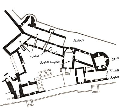
The southern inner bailey forms a more compact, fortified core organized
around an irregular courtyard (sometimes described as rhomboid or
courtyard-focused like contemporary French castles). Key surviving or
documented buildings include:
Chapel (constructed 1186): A
Romanesque-style structure in the inner courtyard, with a nave, apse,
and significant frescoes (including a major Last Judgment scene with
Heaven and Hell scenes, showing multiple painting phases identified by
modern archaeology). It served the religious needs of the Knights
Hospitaller.
Great hall/refectory, chapter house, and additional
halls: Vaulted spaces for meetings, dining, and administration. These
are multi-story in places, with thick walls and functional
Gothic/Romanesque elements.
Dormitories, barracks, kitchens, bakery,
and stables: Living quarters for knights and soldiers, plus utilitarian
facilities like ovens and storage. The layout supported a large
garrison.
Courtyards and ancillary spaces: Upper and lower areas with
vaulted undercrofts.
Many structures feature high-quality
stonework, including semicircular Corinthian-order pilasters in the
chapel and mountain-rooted columns in some vaulted areas. The entire
inner complex was designed for prolonged sieges, with integrated
barracks, storerooms, and living spaces.
Water Management and
Support Systems
A sophisticated system of rock-cut cisterns and
vaults (hewn from the basalt bedrock beneath the buildings) collected
and stored rainwater, essential for autonomy. An advanced network of
drains, pipes, and distribution channels (studied in recent
Syrian-Hungarian Archaeological Mission excavations) supplied the
castle. An external cistern supplemented internal supplies. These
features, combined with the outer ward’s agricultural capacity, made
Margat exceptionally resilient.
Architectural Significance and
Later History
Margat represents the height of concentric Crusader
design in the Levant: layered defenses, integrated natural and
artificial barriers, and self-sufficient internal organization. The
Hospitallers (who purchased and massively expanded it after 1186) turned
it into their Syrian headquarters. It remained in use through Mamluk (as
a prison and administrative center) and Ottoman periods, with repairs
and adaptations. Modern excavations (e.g., by the Syrian-Hungarian
Archaeological Mission under Balázs Major) have clarified building
phases, functions, and details like frescoes and water systems,
confirming its exceptional preservation relative to other sites.
Today, it stands as a ruined but monumental testament to medieval
fortification, damaged in places by earthquakes and time but still
conveying its imposing scale and ingenuity. Its black basalt silhouette
rising from the hill remains one of Syria’s most striking medieval
landmarks.
Historical Context (Quick Overview for Visitors)
Early
fortifications date to 1062 (Muslim era), with major Crusader
development by the Knights Hospitaller from the late 12th century.
It
served as their Syrian headquarters—second only to Krak des Chevaliers
in size and power.
It withstood sieges (including by Saladin, who
bypassed it as impregnable) before falling to Mamluk Sultan Qalawun in
1285 after a 38-day siege involving mining.
Later used by Mamluks,
Ottomans, and into the modern era; it suffered earthquake damage in 2023
but remains a ruin under some renovation.
The concentric design,
thick basalt walls, towers, bent entrances, large outer ward, chapel,
cisterns, and barracks highlight advanced medieval military
architecture.
Current Status (as of 2026)
The castle is open
to the public during daylight hours (typically ~09:00–17:00, confirm
locally). It is a ruin but accessible, with ongoing or recent
restoration efforts. Tourism in coastal Syria (Tartus/Latakia area) is
resuming under the new government, though the site is less visited than
Krak des Chevaliers.
Entrance fee: Modest (reports suggest around
100,000 SYP or ~$10 USD equivalent; prices can fluctuate with currency
changes). Local guides may be available on-site or arrangeable.
How to Get There
Location: ~6 km south of Baniyas, ~2 km inland from
the Mediterranean, ~30–40 km north of Tartus. The drive up the hill is
scenic with coastal and hill views.
From Tartus: 40-minute scenic
drive north along the coast.
From Baniyas: Taxi or microbus; final
approach may involve a short walk uphill.
Best base: Tartus or
Latakia for coastal stays; day-trip possible from Homs or Damascus with
a driver (longer day).
Transport tips: Private car/taxi with a driver
is easiest and safest for tourists. Public options exist but are less
reliable for foreigners. Roads have checkpoints—carry passport/ID and
visa docs.
Combine with nearby sites: Pair with Krak des
Chevaliers (inland, another Hospitaller masterpiece), Safita (Chastel
Blanc, for signaling history), or coastal spots like Tartus old
city/Arwad Island.
Visiting Tips
Best time to visit: Spring
(March–May) or autumn (Sept–Nov) for mild weather, good visibility, and
fewer crowds. Summers are hot/dry; winters can be wet and windy on the
exposed hill. Early morning or late afternoon for best light and fewer
people.
Duration: 1–2 hours to explore thoroughly (outer ward, inner
areas, towers, views). Allow extra for photos and wandering.
What to
wear/bring:
Sturdy walking shoes—uneven rocky paths, ruins, stairs,
and slopes.
Sun protection, hat, sunglasses, water (limited
shade/facilities).
Modest clothing (respect local norms:
shoulders/knees covered).
Flashlight for darker chambers; binoculars
for sea views.
On-site: Limited facilities (possible basic
toilets). No major cafe—bring snacks. Guided tours add depth (history,
sieges, architecture).
Photography: Excellent for panoramas, basalt
textures, ruins, and coastal vistas. Drones likely restricted—check
rules.
Safety and Practical Considerations
Syria's overall
situation has improved significantly since the 2024–2025 political
changes, with visas on arrival (at Damascus airport or Lebanon/Jordan
borders) for many nationalities and resuming tourism, especially on the
coast. However, most governments still advise against all travel due to
risks of instability, checkpoints, and residual issues.
Travel
with a reputable local tour operator or licensed guide for logistics,
permits, and safety—highly recommended for first-timers or independent
travel.
Expect military/police checkpoints; stay calm, follow
instructions, and don't photograph sensitive areas/military.
Health:
Standard precautions; tap water not recommended; medical facilities
limited outside major cities.
Currency: Syrian pounds (cash
preferred); cards limited.
Respect: The area has mixed communities
(Sunni, Alawite nearby)—be culturally sensitive.
Margat is less
restored than Krak des Chevaliers, so expect a more rugged, atmospheric
experience with dramatic ruins and sweeping views rather than polished
tourism infrastructure. It's ideal for history enthusiasts,
photographers, and those seeking an authentic Crusader fortress feel off
the main tourist path.