Location: Lake Assad, Ar- Raqqah Governorate Map
Qal'at Ja'bar (Arabic: قلعة جعبر, also known as Ja'bar
Castle or Caber Kalesi in Turkish; ancient name Qal'at Dawsar or
Dawsara) is a medieval Islamic fortress in Syria's Raqqa Governorate,
perched on what was once a prominent hilltop overlooking the Euphrates
River. Today, it sits as an island in the artificial Lake Assad (created
by the Tabqa Dam in the late 1960s–1970s), connected to the mainland by
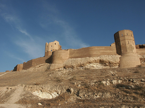
a narrow causeway. The castle spans roughly 370 by 170 meters (about
1,210 by 560 feet) and features a stone-built outer wall with 35
bastions encircling a rocky core, a dry moat in places, baked-brick
upper structures, a gatehouse with a winding rock-cut ramp entrance,
vaulted halls, and a prominent cylindrical minaret.
Its strategic
location controlled a key Euphrates crossing linking Raqqa (an important
Abbasid-era center) to western Syria and beyond, making it a vital
military, trade, and frontier stronghold for over a millennium. While
the hilltop may have seen early fortifications, the visible structures
primarily date to the 12th-century Zengid period under Nur ad-Din Zangi,
with influences blending Syrian and Mesopotamian (Eastern Islamic)
architectural styles.
Early Origins and Pre-Castle Period (7th–11th Centuries)
The exact
date of initial fortification remains uncertain, but evidence points to
the hilltop being strengthened as early as the 7th century (possibly
late Byzantine or early Islamic period), serving as a defensive outpost
along the Euphrates valley. In pre-Islamic and early Islamic times, the
site was known as Dawsar/Dawsara and lay on an important route between
Raqqa and western regions.
By the 11th century (AH 5th century), it
gained major strategic importance as a Euphrates crossing point. It
first appears in historical records around 1040/41 during a campaign by
the Fatimid governor Anushtakin al-Dizbari. The castle acquired its
modern name from Ja'bar ibn Sabiq al-Qushayri (or from the Banu
Numayr/Banu Qushayr tribe), a local tribal leader who occupied and
likely fortified the site before his death in 1071/72. During this era,
it developed a reputation as a base for Bedouin highwaymen and raiders
from these tribes.
In 1086, the Seljuk sultan Malik Shah I conquered
the area and granted the fortress to the Uqaylid dynasty (a local Arab
Muslim line nominally under Seljuk Aleppo), specifically to commander
Salim ibn Malik ibn Badran as compensation related to Aleppo's
surrender. The Uqaylids held it (with some interruptions) until the late
12th century. Archaeological studies of pottery from the site confirm
continuous occupation and cultural ties to the broader Jazira region
from the late 11th century onward.
Crusader Era, Zengid Takeover,
and Major Construction (12th Century)
The castle briefly fell to
Crusader forces in 1102 during their expansion into northern Syria but
was soon recaptured by Muslim forces. A pivotal event occurred in 1146
when the atabeg Imad ad-Din Zengi (ruler of Mosul and Aleppo) besieged
it but was assassinated there by one of his own slaves—highlighting the
site's role in regional power struggles.
In 1168, Zengi's son Nur
ad-Din Mahmud Zangi (r. 1146–1174) seized Qal'at Ja'bar from the
Uqaylids, incorporating it into his Aleppine emirate. This marked the
most transformative phase: Nur ad-Din ordered extensive rebuilding and
restorations, especially after major earthquakes in 1157 and 1170. Most
of the surviving structures—fortification walls, towers (semi-circular,
semi-octagonal, or rectangular), the gatehouse, and interior
features—date to this period. He also commissioned a striking
cylindrical minaret on a square base (unique in western Syria but common
in Iranian/Mesopotamian traditions), featuring an inscription band
naming Nur ad-Din, decorative saltire crosses, dogtooth moulding, and
patterned brickwork. This reflects strong Eastern (Mesopotamian/Iranian)
influences on the architecture, using mud bricks more typical of Iraq
and Iran than local Syrian square-minaret styles.
The fortress
shifted from a western-oriented defense (against Byzantines or early
Crusaders) to an eastern stronghold within the Zengid domain.
Ayyubid, Mongol, and Later Medieval Periods (Late 12th–14th Centuries)
After Nur ad-Din's death, the site passed to the Ayyubids in 1193 under
Saladin's brother al-Adil, who ruled al-Jazira. It became a key eastern
outpost in the Ayyubid state, oriented against rival Zengids in Mosul.
Architectural and decorative elements continued to show Mesopotamian
influences.
The Mongols under Hülegü largely destroyed the fortress
during their invasions of Syria around 1258–1259, leaving it in ruins.
Limited restorations occurred in the 14th century (likely under Mamluk
influence), but it never regained its former prominence. Pottery finds
analyzed in archaeological studies (e.g., Cristina Tonghini's work on
11th–14th century ceramics) provide a detailed chronology of occupation,
showing shifts in trade, daily life, and regional connections amid these
upheavals.
Under later Mamluk and early Ottoman rule, the castle
declined as a military site, though its location retained symbolic and
local significance.
Ottoman Era and the Tomb of Suleyman Shah
(13th–20th Centuries)
The castle's later fame ties to the nearby Tomb
of Suleyman Shah (Mezār-i Türk), traditionally identified as the burial
site of Suleyman Shah, grandfather of Osman I (founder of the Ottoman
Empire), who reportedly drowned in the Euphrates nearby in 1236 (though
some historians suggest possible confusion with a Seljuk figure like
Sulayman bin Kutalmish). The tomb was reconstructed by Ottoman Sultan
Abdülhamid II.
This association proved crucial in the 20th century.
Under Article 9 of the 1921 Treaty of Ankara (and reaffirmed in later
agreements like the Treaty of Lausanne), the tomb area and its
surroundings became a Turkish exclave—sovereign Turkish territory within
Syria, guarded by Turkish soldiers and flying the Turkish flag. This
made Qal'at Ja'bar (and the adjacent tomb site) a unique geopolitical
anomaly from 1921 until 1973.
Modern Era: The Dam, Relocation,
and Syrian Civil War (1960s–Present)
Construction of the Tabqa Dam
(1968 onward) created Lake Assad, flooding the Euphrates valley and
turning the hilltop castle into an island (though the elevated site
itself stayed above water). Between 1965 and 1974, the Syrian
Directorate-General of Antiquities and Museums (DGAM), with UNESCO
support, conducted excavations, restorations, and protective works
(including a glacis and causeway). In 1973, to avoid flooding, the
Suleyman Shah tomb and Turkish exclave were relocated northward (to a
site near Karakozak); the castle itself reverted fully to Syrian
control.
A small on-site museum operated in the 1980s but has since
closed. The castle remained a Syrian national monument, featured in
tourism materials.
During the Syrian Civil War, Islamic State
(ISIL/ISIS) forces captured it in 2014 as part of their Raqqa offensive,
reportedly using the grounds for training, tunnels, and weapons storage.
Syrian Democratic Forces (SDF) retook it on January 6, 2017, during the
broader Raqqa campaign, with clashes killing around 22 ISIL fighters.
Some damage likely occurred, though major structural harm reports are
limited; post-war erosion and neglect pose ongoing risks in the region.
As of recent years (into the mid-2020s), the castle lies in
SDF/AANES-controlled territory near Raqqa. Limited access for visitors
or research is possible with local permissions, though formal tourism
infrastructure remains minimal.
The current structures date primarily to a major rebuild under
the Zengid ruler Nur ad-Din Zangi starting in 1168 CE, following
earlier possible Byzantine/early Islamic fortifications and
11th-century use by the Banu Numayr and Uqaylids. It served as a
strategic stronghold controlling a key Euphrates crossing.
Earthquakes in the 1150s–1170s prompted extensive repairs, and later
Ayyubid and 14th-century work added layers. Mongol destruction in
1258–59 left it ruined, but visible fabric today largely reflects
the 12th-century Zengid phase with modern Syrian Directorate-General
of Antiquities restorations (especially brickwork).
Overall
Layout and Dimensions
The fortress forms an elongated, irregular
polygonal enclosure that closely follows the natural contours of the
underlying rock hill/core for defensive advantage. Sources give
slightly varying measurements (likely reflecting inner vs. outer or
restored extents):
Approximately 320 m north–south by 70 m
east–west (core fortress dimensions).
Or 370 m by 170 m overall.
It encloses a central courtyard and functional areas, with the
entire complex oriented toward the river valley for oversight. The
layout is often compared to the better-preserved Citadel of
Aleppo—another Zengid project—featuring concentric defenses around a
raised core. A large open courtyard once contained barracks,
residential quarters, storage, and religious spaces.
Defensive System: Walls, Towers, and Moat
The primary defensive
feature is a double curtain wall system (two concentric walls
separated by a narrow space), both pierced with arrow slits for
archers. The outer walls are thick, built of finely cut limestone
ashlar masonry (lower sections) rising from a sloping glacis
(protective base) in places. Upper sections and parapets transition
to baked/mud bricks, a technique showing strong Mesopotamian/Eastern
Islamic influence rather than purely local Syrian stone traditions.
Projecting from the walls are more than 35 salient towers/bastions
(some sources say over 30) in semi-circular, semi-octagonal, and
rectangular plans. These enabled enfilading (flanking) fire, making
it difficult for attackers to approach or deploy siege engines. The
towers and walls together created overlapping fields of fire across
all approaches. The fortress was partially surrounded by a dry moat
carved into the terrain, adding an extra barrier.
This
combination of rock-core adaptation, double walls, multi-shaped
towers, and moat made Qal'at Ja'bar a formidable example of
12th-century Islamic military architecture optimized for the
Euphrates steppe environment.
Entrance and Access
The
original main entrance was a fortified gatehouse (one source places
it at the southwest corner, protected by two flanking towers and
crowned by a small arch). Access to the inner fortress involved a
winding ramp cut directly out of the living rock, providing
controlled, defensible ascent. A large vaulted building directly
above or near the gate features well-preserved brick decoration.
Today, visitors approach via a modern causeway from the east
(connecting the peninsula to the mainland), leading through the
gatehouse area. Inside, arched passages and stone staircases branch
to different sections of the fortress.
Interior Structures
and Key Features
The interior is organized around a central
courtyard with functional zoning for a garrison:
Storage and
support: Cellars, granaries, and rooms for food/water provisions
during sieges.
Living quarters: Barracks and residential areas
for soldiers and staff.
Religious spaces: Remains of prayer halls
or a small central mosque.
Most prominent interior element:
the cylindrical minaret. Located roughly in the middle of the
fortress, it is the highest surviving point and one of the most
architecturally distinctive features. Built (or completed) under Nur
ad-Din (inscription dated to the late 12th century), it rests on a
5-meter-high square base. The shaft itself is cylindrical—uncommon
in western Syria (where square minarets dominated, e.g., at Aleppo’s
Umayyad Mosque)—and draws clear inspiration from Iranian and Iraqi
precedents. Construction uses baked brick throughout.
Decorative program (from base upward):
Inscription band naming
Nur al-Din.
Bands of continuous saltire crosses (X-shaped motifs)
bordered by dogtooth moulding.
Upper section: four arched windows
linked by a single row of pearl motifs, interspersed with inlaid
lozenge (diamond) patterns of patterned brick.
This minaret
exemplifies the blend of military and religious architecture under
Zengid patronage and highlights Eastern artistic influences
penetrating Syria in the 12th century.
Other surviving interior
elements include remains of vaulted halls (barrel-vaulted spaces
likely used for assembly, administration, or storage) and scattered
foundations of additional structures. Many roofs have collapsed over
time, but the overall layout remains legible on the ground.
Materials, Techniques, and Influences
Stone (limestone ashlar):
Primary for lower defensive walls and foundations—durable and
locally sourced.
Baked/mud brick: Dominant in upper walls,
towers, minaret, and decorative elements. Brick allowed for
intricate patterns (inscriptions, geometric motifs) and was lighter
for taller structures.
Techniques reflect a hybrid: local Syrian
defensive traditions merged with Eastern (Iraqi/Iranian) brickwork
aesthetics, likely due to Zengid connections across the region.
Current Condition and Significance
Extensive 20th-century
restorations stabilized the walls and brickwork. The fortress now
appears as a striking ruin complex rising from the lake, with its
golden-toned stone and brick contrasting the blue water. While not
fully intact, the surviving walls, towers, ramp, vaulted remains,
and especially the decorated minaret provide an excellent case study
of Zangid/Ayyubid military architecture, showing how fortresses
combined raw defensive power with sophisticated Islamic decorative
arts.
When construction of the Tabqa Dam began in 1968, the flood plain - i.e. H. also at Jaʿbar Castle - several rescue excavations and restoration work were carried out. Since the castle was quite high and would therefore not be flooded by the water, but would only be surrounded, it was equipped with a protective dam and an elevated footpath between 1965 and 1974. This work was carried out by DGAM and UNESCO and cost 4 million Syrian lira. The work focused on the eastern wall and the towers. In addition, parts of the western wall were restored. To speed up the restoration work, a small brick kiln was set up near the castle. The “Donjon Alia” was also renovated in order to exhibit finds from the excavations there. However, this did not happen; The finds will instead be shown in the Aleppo National Museum and the museum in Raqqa.