Location: 40 km South of Deir Ezzor Map
Constructed: 9th century
Rahbeh Castle, also known as Qala’at Rahbeh, Qal'at al-Rahba (قلعة
الرحبة), Al-Rahba Fortress, or Qala'at Malek ibn Tauk (after its
founder), is a medieval Arab fortress in Syria. It stands on a
natural/artificial mound (elevation ~244 m) on the southwestern edge
of the Euphrates River valley, about 4 km from the river, 1 km
southwest of the modern town of al-Mayadin (Mayadin), and roughly
40–42 km southeast of Deir ez-Zor in Deir ez-Zor Governorate.
The site overlooks the Syrian Desert steppe to the west and the
Euphrates plain to the east, earning descriptions like “the end of
Iraq and the beginning of al-Sham [Syria]” from medieval traveler
Ibn Battuta. Today, it is largely in ruins due to centuries of wind
erosion, earthquakes, and abandonment, but its imposing
remains—built primarily of mudbrick with limestone, gypsum, and
puddingstone reinforcements—still dominate the landscape.
Etymology and Strategic Importance
The name al-Raḥba derives from
Arabic for “the flat part of a wadi where water collects.” The original
settlement was called Rahbat Malik ibn Tawk (or Rahbat al-Sham) after
its Abbasid founder. It served as a critical military, administrative,
and commercial hub: the “key to Syria” (and sometimes Iraq) for
caravans, armies, and travelers moving along the Euphrates route to
Aleppo or across the desert to Damascus. Bedouin tribes frequently used
it as a launchpad for raids into northern Syria and as a marketplace.
Its position made it a contested prize among rival Muslim powers for
centuries.
Founding in the Abbasid Period (9th Century)
The
fortress’s origins trace to the second half of the 9th century during
the Abbasid Caliphate. Abbasid general Malik ibn Tawk al-Taghlibi (also
spelled Tawq or Tauk; died 873/874 CE) established it under Caliph
al-Ma’mun (r. 813–833 CE) or shortly thereafter. Earlier claims linking
it to Harun al-Rashid (late 8th century) appear inconsistent with
primary sources like the 9th-century historian al-Baladhuri, who noted
no prior trace of an old city at the site.
Malik ibn Tawk served as
its first lord. After his death, his son Ahmad succeeded him but was
expelled in 883 CE when the site was captured by the Abbasid lord of
al-Anbar, Muhammad ibn Abi’l-Saj. By the 10th century, al-Rahba had
grown into a substantial town with irrigated lands, date palms, and
orchards. It faced early threats, including imprisonment of Qarmatian
leader al-Husayn ibn Zikrawayh in 903 CE and a Qarmatian massacre under
Abu Tahir al-Jannabi in 928 CE.
10th–11th Centuries: Contested
Rule (Hamdanids, Buyids, Fatimids, Uqaylids, Mirdasids, and Seljuks)
The fortress changed hands frequently amid regional power struggles:
Hamdanid period (mid-10th century): It formed part of the Euphrates
district under the Mosul-based emirate. Internal rebellions (e.g., by
lord Jaman) and dynastic disputes followed the death of Nasir al-Dawla
(r. 929–968/9). It passed among Hamdanid sons before falling to the
Buyid emir Adud al-Dawla in 978 CE. Geographer al-Muqaddasi (late 10th
century) described it as a semi-circular town with a strong fortress and
fertile surroundings.
Early 11th century: Contested between Uqaylids
of Mosul and Fatimids of Egypt. Fatimid-appointed lords (e.g., Abu Ali
ibn Thimal of the Al Khafajah tribe) clashed with Uqaylid and local
figures. Mirdasid emir Salih ibn Mirdas seized it around the
1040s–1050s, using it as his first major base before expanding to
Aleppo. It briefly fell to Fatimid ally Arslan al-Basasiri (1059) before
returning to Mirdasid control under Atiyya.
Seljuk period (late
11th–early 12th centuries): Seljuk Sultan Malik-Shah granted it to
Uqaylid allies in 1086. It changed hands through sieges and revolts,
including captures by Tutush (ruler of Damascus) in 1093, looting by
Karbuqa of al-Hillah (1096–1102), and control by mamluk commanders like
Qaymaz and Jawali (conquered 1107 after a siege). By 1127, it fell under
Zengid influence via Izz ad-Din Mas’ud ibn al-Bursuqi.
12th
Century: Zengid-Ayyubid Reconstructions and the 1157 Earthquake
Under
Nur al-Din Zengi (r. 1146–1174), defenses were strengthened. A
devastating earthquake on August 12, 1157, destroyed much of the
original Euphrates-side settlement (Rahbat Malik ibn Tawk), along with
Hama and other cities. Nur al-Din granted the site (and Homs) as a fief
to his commander Shirkuh (Asad al-Din Shirkuh, uncle of Saladin) in
1161/1164. Shirkuh rebuilt the fortress—sometimes called al-Rahba
al-Jadida (“New Rahba”)—relocating it ~5 km west to the desert edge for
better defensibility. This created the core of the structure visible
today: a “fortress within a fortress” with an inner pentagonal keep (60
× 30 m) inside a larger triangular enclosure (270 × 95 m), featuring a
deep moat, bastions, merlons, corridors, chambers, cisterns, and
water/sewage systems.
After Shirkuh’s death, it reverted to Nur
al-Din, then passed to Saladin (who conquered it by 1182 and granted it
hereditarily to his son Nasir ad-Din Muhammad). In 1207, Shirkuh’s
grandson al-Mujahid Shirkuh II (r. 1186–1240) carried out a major third
reconstruction, demolishing ruins and fortifying it further as the
easternmost stronghold in his Homs-based Ayyubid emirate (alongside
Homs, Salamiyah, and Palmyra).
Mamluk Period (13th–14th
Centuries) and Mongol Threats
The Mamluks annexed the Ayyubid emirate
in 1260. Sultan Baybars replaced the Ayyubid governor with a mamluk
officer in 1264 and restored the fortress, making it the principal
bulwark against Mongol incursions and the key Euphrates stronghold
(supplanting Raqqa). It served as an administrative center and postal
relay; refugees from Mongol-devastated areas settled nearby (including
at Mashhad al-Rahba, modern Mayadin). It withstood Mongol sieges, such
as one by Kharbanda in 1312, thanks to its impregnable design. An
Ayyubid-era palace-like structure and multiple construction phases (at
least eight from the early Ayyubid onward) added bastions, glacis, and
reinforcements.
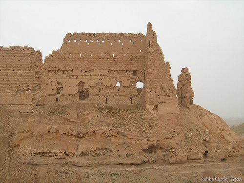
Decline and Modern State
After the Mongol
invasions (mid-13th century onward), the site gradually declined and was
largely abandoned. Wind erosion took a heavy toll on its mudbrick
construction (unlike the stone-built western Syrian castles).
French-Syrian archaeological missions conducted excavations and partial
restorations starting in the late 20th century (notably 1978), but it
remains in poor condition—impressive yet weathered ruins with visible
towers, walls, and the mound’s dramatic profile.
The castle’s
multi-phase architecture reflects its long history: early mudbrick
phases, Ayyubid/Mamluk stone reinforcements, and adaptive repairs after
earthquakes and sieges. Though no longer inhabited, it stands as a
testament to medieval Islamic military engineering and the turbulent
politics of the Euphrates frontier.
The castle's architecture reflects Islamic medieval military design,
with multiple construction and restoration phases spanning the Abbasid,
Zengid, Ayyubid, and Mamluk periods. It is now largely ruined due to
wind erosion, earthquakes, and the use of mudbrick as the primary
material, but its imposing scale and defensive ingenuity remain evident.
Overall Layout and Dimensions
The fortress is a classic
concentric design with two main defensive layers:
Outer enclosure: A
pentagon-shaped (or irregular triangular plan with chamfered angles
replaced by short curtain walls) wall measuring approximately 270 by 95
meters (886 ft × 312 ft). This forms the primary perimeter around the
artificial mound.
Inner keep (citadel core): A four-story,
pentagon-shaped central stronghold measuring roughly 60 by 30 meters
(197 ft × 98 ft). It functions as a self-contained "fortress within a
fortress," connected to the outer fortifications by corridors and
chambers. The lowest level houses a large cistern for water storage.
The entire complex stands on an elevated artificial mound surrounded
by a massive defensive moat 22 meters (72 ft) deep and 80 meters (260
ft) wide—deeper than many contemporary Ayyubid desert fortresses (e.g.,
Palmyra or Shumaimis).
A medieval settlement once existed at the foot
of the mound within a quadrangular enclosure (walls up to 30 m long, 4 m
high, and 1 m thick), including probable remains of a khan
(caravanserai), a congregational mosque with a small oratory, and
cavalry barracks, supported by a canal system for water and sewage.
Materials and Construction Techniques
The castle was built
primarily with mudbrick (rather than the large stone blocks common in
western Syrian Crusader-era castles), supplemented by limestone, gypsum
mortar, and puddingstone (conglomerate blocks) for reinforcements. This
brick-heavy construction contributed significantly to its erosion over
time, as the elements have worn down the structures heavily since
abandonment after the Mongol period.
Wall thickness is generally
around 1 meter (3.3 ft). Construction occurred in at least eight undated
phases (starting likely in the early Ayyubid period), each using
slightly different techniques focused on targeted reinforcements rather
than wholesale redesign. These phases added bastions, elevated walls,
casemates, and decorative elements like Arabic inscription bands on
curtain walls.
Defensive Features
The architecture prioritizes
defense against siege artillery and desert attacks, especially on the
western and southeastern sides facing the plateau (where siege engines
could approach closer to wall level):
Bastions/Towers: Positioned
along the outer walls, with the largest and most robust on vulnerable
sides. Examples include one measuring 17.2 by 15.2 meters (56 ft × 50
ft), another 12.4 by 12.4 meters (41 ft × 41 ft), and smaller ones like
a northern bastion at 5.2 by 4.4 meters (17 ft × 14 ft). These supported
heavy defensive artillery and were taller than equivalents in nearby
fortresses.
Walls and Parapets: Both outer walls and the inner keep
feature merlons and parapets. The keep's parapets sit 6.5 meters higher
than the outer ones, allowing archers a secondary defensive line even if
the outer wall was breached. Later phases added low-lying casemates
(covered platforms) along western and southwestern curtains for defender
positioning.
Glacis and Slope Reinforcement: The northern slope (less
vulnerable) includes a glacis of large conglomerate blocks for added
stability and to hinder approaches.
Moat: The exceptionally deep and
wide moat encircling the mound was a key deterrent, making direct
assaults extremely difficult.
Key Architectural Phases and
Evolution
9th century (Abbasid, first construction): Built by Malik
ibn Tawk (~854 CE) as Rahbat Malik ibn Tawk, establishing the core
layout with mudbrick walls.
Mid-12th century (Zengid/Ayyubid
reconstruction): After the 1157 earthquake destroyed much of the
original, Nur al-Din and Shirkuh rebuilt it (known as al-Rahba
al-Jadida), adding significant defenses.
1207 (Ayyubid major
rebuild): Under Shirkuh II (al-Mujahid), the site was largely demolished
and reconstructed with enhanced fortifications.
Later Mamluk phases
(13th–14th centuries): Multiple restorations (e.g., under Baybars)
strengthened walls against Mongol sieges, including post-damage repairs
using reused masonry. These added height to western walls and smaller
bastions.
The design evolved to emphasize the desert-facing sides
while leaving the river/northern side relatively unchanged.
Current State and Significance
Today, the castle is in a poor state
of preservation—ruined walls, towers, and the keep dominate the
landscape but show heavy erosion. French-Syrian excavations (notably
1978 onward, with detailed studies by archaeologists like J.L. Paillet)
have revealed much of the layout, though no complete public floor plans
are widely available online. It remains an impressive example of
medieval Islamic military architecture, blending strategic location,
layered defenses, and adaptive construction techniques suited to the
Euphrates frontier environment.
Precise Location and Regional Context
Coordinates: Approximately
35°00′18″N 40°25′24″E (or very close variants like 35.005°N 40.423°E).
Relative distances:
About 1 km (0.62 mi) southwest of the modern town
of al-Mayadin (Mayadin).
Roughly 4 km (2.5 mi) southwest of the
Euphrates River’s west bank.
42 km (26 mi) southeast of Deir ez-Zor,
the governorate capital.
It occupies the southwestern edge of the
Euphrates river valley, placing it in the transitional zone (ecotone)
between:
The fertile alluvial floodplain of the Euphrates to the
northeast and east (historically supporting intensive irrigation, date
palm groves, orchards like quince, and agriculture).
The arid Syrian
Desert plateau to the west and southwest (a vast steppe/desert landscape
of gravelly plains, low rocky hills, and sparse vegetation suited mainly
to nomadic pastoralism).
The site’s Arabic name al-Rahba (or
al-Raḥba) derives from the term for “the flat part of a wadi where water
collects,” reflecting its original placement in a low-lying,
occasionally flood-prone area along the Euphrates.
Topography and
Elevation
The castle stands atop an artificial mound (partly natural,
partly human-modified) at an elevation of 244 meters (801 ft) above sea
level. This mound is detached from the main Syrian Desert plateau
immediately to its west, creating a prominent, isolated hill that rises
sharply above the surrounding plain.
Key topographic features
include:
A deep, wide moat (22 m / 72 ft deep and 80 m / 260 ft wide)
carved around the base of the mound, enhancing its defensibility and
visually isolating the structure.
The fortress itself is compact and
layered (“a fortress within a fortress”): an inner pentagonal keep
(roughly 60 × 30 m) enclosed by a larger triangular outer enclosure
(approx. 270 × 95 m), with bastions, curtain walls, and parapets adapted
to the mound’s contours.
From the summit, there are panoramic views:
eastward over the green Euphrates valley and floodplain (including the
river itself in the distance), and westward/southwestward across the
open, barren desert steppe.
This elevation and isolation give the
site exceptional strategic visibility and defensibility — it overlooks
caravan and military routes along the Euphrates while using the desert
as a natural barrier to the rear.
Historical Shifts in Site
Location
The original fortress (founded in the 9th century by Abbasid
official Malik ibn Tawk / Tauk, hence the alternative name Rahbat Malik
ibn Tawk or Qala'at Malek ibn Tauk) stood directly on the western bank
of the Euphrates. It served as a key waypoint for caravans and armies
traveling the Iraq–Syria route.
A major earthquake in 1157 destroyed
much of the original riverside settlement. The current structure
(largely rebuilt in the Ayyubid period, with significant work by Shirkuh
II around 1207) was relocated a few kilometers westward to its present
mound closer to the desert edge. This new position (“al-Rahba
al-Jadida”) traded direct river access for better defensibility and
oversight of both valley and desert routes.
Climate and
Environmental Factors
The region has a hot desert climate (BWh):
extremely hot, dry summers (often exceeding 40°C / 104°F), mild winters,
and very low annual precipitation (typically under 150 mm / 6 in, mostly
in winter). Strong winds are common, contributing to significant wind
erosion that has badly degraded the mudbrick and stone ruins over
centuries.
Near the river, irrigated agriculture persists today
(fields, palms, and settlements), but the castle mound itself sits in a
more barren transitional zone. The surrounding desert plateau features
typical Badia terrain: gravel plains, occasional wadis, and low scrub.