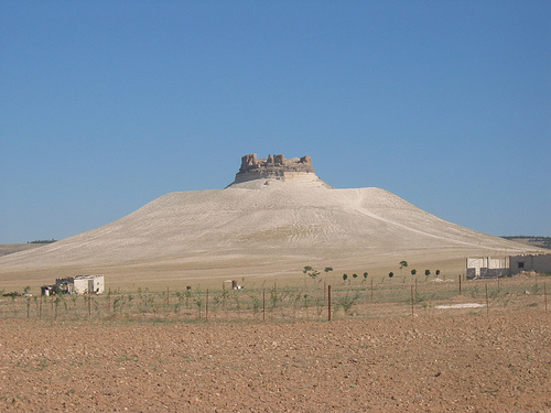
Location: 30 km South-east of Hama Map
Found: 1st century BC by Arab dynasty of Sempsigerami
Shmemis (Arabic: قلعة شميميس, also spelled ash-Shmemis, ash-Shmamis,
Shumaymis, or Qal'at Shmamis/Qal'a Shmemis) is not a town or village
but a historic ruined castle and archaeological site in Syria's Hama
Governorate. It sits atop an extinct volcanic cone known as al-Ola
(or al-A'la) Heights, about 3 km northwest of Salamiyah and roughly
27–30 km southeast (or east) of Hama.
The site rises prominently
above the surrounding plains (elevation around 533 m), offering
panoramic views for over 50 km. Its strategic position made it a
natural fortress controlling trade routes, fertile agricultural
lands, and caravan paths across the Syrian steppe. The name
"Shumaymis" (or Shmemis) is thought to mean "Little Sun," likely
referencing the Roman sun god Apollo or the local Arab deity Haddad,
tying into the area's ancient solar cult associations.
The
castle's distinctive oval plan follows the flattened summit of the
volcano (roughly 81 m wide). It features thick basalt stone walls,
an entry gate flanked by square towers in the northeast, 11 evenly
spaced square towers (6–8.8 m wide) along the perimeter, a deep
surrounding moat/ditch (about 15 m deep and 20 m wide), internal
wells (one ~80 m deep connected to a canal), traces of a central
rectangular fortress/palace (33 × 35 m), soldier quarters, and a
portico for defenders. Today, it stands mostly in ruins, with the
best-preserved elements at the gate and outer walls.
Ancient Origins: Hellenistic Foundation (Late 2nd–1st Century BC)
The site's use as a fortification dates back to ancient times due to its
natural defensibility. The earliest known castle was constructed in the
late 2nd or 1st century BC by Sampsiceramus I (also associated with the
Shamisgram/Shamsigram family), the founder and first Priest-King of the
Emesene (Emesa) dynasty. This Arab priestly royal family ruled the
region around Emesa (modern Homs) as a Roman client kingdom, known for
their solar cult and control over key territories.
Sampsiceramus I
(who also helped develop nearby Salamiyah) built the original structure
as a strategic stronghold. The Emesene dynasty maintained ties to Rome
while preserving local Arab-Hellenistic traditions. Most of this early
structure was later destroyed by an earthquake (or series of seismic
events).
Roman, Byzantine, and Sassanid Eras (1st–7th Centuries
AD)
Under Roman and later Byzantine rule, the site continued as a
fortified outpost. It suffered further damage from earthquakes and
military conflicts. A major destruction occurred in 613 AD when the
Sassanid Persian king Khosrau II razed it during his campaigns against
the Byzantine Empire.
Some accounts note possible earlier
reconstructions or use during the Byzantine period (e.g., links to
Emperor Justinian I in the 6th century), but these are less consistently
documented. The fortress's role remained military and observational amid
regional power struggles.
Medieval Islamic Period: Zangid and
Ayyubid Reconstructions (12th–13th Centuries)
A significant
earthquake in 1157 AD (AH 552) destroyed much of the existing ancient
fortress near Salamiyah. It was subsequently rebuilt or repaired under
the Zangid ruler Nur al-Din Mahmud bin al-Zangi.
The major surviving
form of the castle dates to the Ayyubid era. During the rule of al-Malik
al-Mujahid Shirkuh II bin Muhammad (also called Assad ud-Din Shirkuh II,
Ayyubid governor/prince of Homs, r. 1185–1239), the castle was
comprehensively refortified and expanded around 1228–1230 AD (626–628
AH). Sources vary slightly on the exact year: Abu Fida dates it to 1228,
Muhammad Kurd Ali to 1229, and other records to 1230. This work was part
of Ayyubid internal rivalries, specifically Shirkuh II's campaigns
against the Ayyubid ruler of Hama. The design—oval layout with towers
and moat—mirrors contemporary Ayyubid fortifications like those at
Palmyra and al-Rahba.
Shmemis remained under Ayyubid control as a key
defensive outpost in the steppe.
Mongol Invasions and Mamluk
Restoration (13th–15th Centuries)
The Mongols under Hulagu Khan
destroyed the castle in 1260 AD (AH 658) during their invasion of Syria.
It was quickly restored the following year (1261) by the Mamluk Sultan
al-Zahir Baybars, who incorporated it into Mamluk defenses. It stayed
under Mamluk administration through the reigns of sultans like al-Mansur
Qalawun (1279–1290), serving as a military stronghold.
Further damage
occurred in 1401 AD during the Tatar (Timurid) invasions under Timur
(Tamerlane), after which it was likely repaired but gradually declined
in strategic importance.
Ottoman Era and Decline (16th Century
Onward)
In the early 16th century, under Ottoman rule, the castle
came under the control of the powerful Druze Ma'ani dynasty. Fakhr
al-Din bin ‘Uthman al-Ma’ani I (r. 1516–1544), a local Druze leader
expanding influence across Syria, Lebanon, and Palestine, acquired
Shmemis along with other territories. After his assassination by Ottoman
authorities in 1544, the castle fell into disuse and ruin.
By the
modern era, it had become a picturesque but largely abandoned ruin, with
limited maintenance.
Modern Context and Significance
Shmemis
Castle has witnessed successive civilizations—Hellenistic/Emesene Arab,
Roman/Byzantine, Persian, Zangid/Ayyubid, Mongol, Mamluk, and
Ottoman—making it a layered historical witness in the Hama countryside.
Its basalt construction, volcanic setting, and "Sword of the Steppes"
nickname highlight its enduring military and symbolic role.
Today,
the ruins are accessible to visitors (reaching the summit involves
hiking steep highlands), though the terrain and moat require care. It
attracts tourists for its dramatic views, historical depth, and
connection to Syria's rich heritage, particularly the Emesene dynasty
and medieval Islamic fortifications. Further archaeological study is
still needed, as it remains relatively under-published.
Precise Location and Regional Context
Shmemis lies in the Hama
Governorate, specifically in the Salamiyah District, approximately 3 km
northwest of the town of Salamiyah and 30 km southeast of the city of
Hama. Its geographic coordinates are 35°02′12″N 37°00′49″E (or
35.0368°N, 37.0135°E).
In broader terms, it sits in the central
Syrian interior, in a transitional zone between the more fertile western
plains (influenced by the Orontes River valley near Hama) and the
semi-arid Syrian steppe (Badiyat al-Sham) that stretches eastward toward
the Syrian Desert. Salamiyah itself lies near the al-A'la (or al-Ola)
plateau to the north, placing Shmemis on the edge of this elevated
steppe terrain. The site is accessible via roads branching northwest
from Salamiyah, with the volcanic hill clearly visible from the
surrounding plains and the main approaches.
Topography and
Geology
The defining geographic feature of Shmemis is its position
atop an extinct conical volcano (sometimes referred to locally as part
of the al-Ola Heights). The castle ruins occupy the flattened rim or
oval summit of this volcanic cone, which measures roughly 81 meters
across at the top. The structure was built directly on a basaltic layer
covering the conical peak.
Elevation: The summit reaches
approximately 533 meters (1,749 ft) above sea level.
Relative
prominence: The surrounding plains near Salamiyah sit at about 460–475 m
elevation, so the volcanic cone rises a modest but visually striking
60–70+ meters above the flat terrain, creating a solitary, mesa-like
hill that stands out dramatically in the otherwise featureless
landscape.
The volcano is long extinct (part of Syria’s limited
volcanic features, which are more prominent farther south in the Harrat
Ash Shaam field or Jabal al-Druze region). The geology consists of dark
basaltic rock, which was quarried locally for the castle’s construction.
A deep defensive moat (15 m deep and about 20 m wide) was excavated
around the summit, enhancing the natural defensive topography.
The
hill’s conical shape and isolated position make it a classic example of
a volcanic plug or cinder cone remnant, now heavily eroded and
integrated into the agricultural steppe.
Surrounding Landscape
and Views
From the summit, the castle commands panoramic 360-degree
views over a circular area exceeding 50 km in diameter. To the west and
southwest lie the broader Hama plains and distant glimpses of the
Orontes River valley; northward is the al-A'la plateau; eastward and
southward stretch the open, rolling steppe and agricultural fields that
characterize central Syria’s interior. The immediate environs consist of
wide open plains with a mix of cultivated fields (wheat, barley, and
other dryland crops) and semi-arid steppe vegetation. The terrain is
largely flat to gently undulating, with occasional low hills or other
minor volcanic remnants visible in the distance.
The soil in the area
is relatively fertile for a steppe zone, derived in part from volcanic
minerals and alluvial deposits, supporting agriculture and grazing.
Groundwater is accessible via wells (the castle itself contains a very
deep internal well for water supply, plus another for provisions).
Climate and Environment
Shmemis and the surrounding Salamiyah
region fall under a cold semi-arid climate (Köppen BSk). Key
characteristics include:
Hot, dry summers (often exceeding 35°C /
95°F).
Mild to cool winters with most of the annual precipitation
(roughly 250–300 mm / 10–12 inches, concentrated in winter months).
Significant diurnal temperature swings and occasional dust storms from
the eastern desert.
Spring and autumn offer the most comfortable
conditions, with green fields and wildflowers in the steppe. Vegetation
consists of drought-resistant grasses, shrubs, and scattered trees
(pines and other hardy species appear in some views of the lower
slopes). The area benefits from slightly higher water availability than
deeper desert zones, thanks to groundwater and occasional wadis.