Location: 26 km to the North-East from
Tirana
Height: 1,613 meters
Area:
29,384 hectares
Mount Dajti National Park, known in Albanian as Parku Kombëtar Mali i Dajtit, is a prominent protected area in central Albania, serving as a natural retreat and biodiversity hotspot just east of the capital city, Tirana. Established as Albania's first national park, it spans 293.84 square kilometers (113.45 square miles) and encompasses the rugged Dajti Mountain range, part of the larger Skanderbeg Mountains. The park's highest point, Maja e Dajtit, reaches 1,613 meters (5,292 feet) above sea level, offering panoramic views of Tirana, the Adriatic Sea, and surrounding landscapes, earning it the nickname "Balcony of Tirana." Located approximately 26 kilometers east of Tirana and 40 kilometers from the Adriatic coast, it is one of the most accessible national parks in the country, attracting families, hikers, and eco-tourists with its lush forests, diverse wildlife, and recreational facilities. Managed jointly by the Albanian Agency of Protected Areas (AKZM) and the Tirana Municipality Parks and Recreation Agency, the park is categorized as a Category II protected area by the International Union for Conservation of Nature (IUCN), emphasizing its role in conservation and sustainable tourism. As of 2025, it remains a vital green lung for the region, hosting up to thousands of visitors annually through amenities like the Dajti Ekspres cable car, while facing ongoing challenges from deforestation and wildfires.
The origins of Mount Dajti National Park date back to 1960, when it was initially designated as Albania's inaugural national park, reflecting early efforts in the country's environmental protection during the communist era. Officially established in 1966 with an initial area of about 3,300 hectares, the park underwent significant expansion in 2006 to its current size of 29,384 hectares to better encompass its ecological diversity and buffer zones. This growth aligned with Albania's broader push for protected areas, integrating it into international networks like the EMERALD network under the Bern Convention, which recognizes sites of special conservation interest. Historically, the area has been inhabited since ancient times, with archaeological evidence of Illyrian settlements and later influences from Roman, Byzantine, and Ottoman periods, though the park itself focuses more on natural rather than built heritage. In the 20th century, it served as a recreational escape for Tirana residents, with developments like the Dajti Ekspres cable car—built in 2005 and touted as the longest in the Balkans at 4.3 kilometers—enhancing accessibility. Recent history includes conservation milestones, such as the opening of a tourist information center in 2019 near the TV and radio towers along the SH47 road in Fushe Dajt. However, the park has endured environmental setbacks, including major forest fires in 2012 and 2019 that scorched areas like Priska summit and required helicopter interventions, with fires becoming more frequent due to climate change and human activity. As of 2025, ongoing projects under initiatives like "NGOs for Biodiversity Conservation" (supported by the Swedish International Development Cooperation Agency) aim to bolster protection and community involvement, addressing issues like illegal logging and promoting sustainable practices.
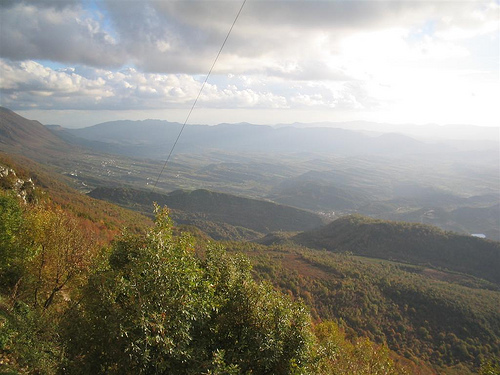
Geographically, Mount Dajti National Park is characterized by a fragmented and rugged terrain within the Skanderbeg Mountains, creating a mosaic of ecosystems from valleys to high peaks. It lies at coordinates 41°21′57″N 19°55′32″E, bordering adjacent protected areas such as Shtamë Pass Nature Park to the northwest, Kraste-Verjon Protected Landscape to the west, and Mali me Gropa-Bizë-Martanesh Protected Landscape to the east. The park's elevation ranges from lower foothills around 600 meters to the summit of Dajti at 1,613 meters, with other notable peaks like Tujani at 1,580 meters. Rivers like the Erzen carve through the landscape, forming features such as the Skorana Gorge and Shëngjini Waterfalls near Shëngjergj village. The environment benefits from a Mediterranean climate with alpine influences at higher altitudes: summers are warm and dry, often exceeding 25°C (77°F) at lower elevations, while winters bring cooler temperatures, occasional snowfall above 1,000 meters, and higher precipitation supporting lush vegetation. The park's proximity to the Adriatic Sea moderates extremes, fostering a humid microclimate in forested areas. Environmental challenges include deforestation from fires and human encroachment, with visible scars from 2019 blazes still evident in 2025, prompting reforestation efforts. Overall, the park's diverse topography—encompassing scrublands, forests, and rocky summits—supports its status as an Important Plant Area of international significance, as recognized by Plantlife.
Mount Dajti National Park is a biodiversity hotspot, hosting an impressive array of flora and fauna due to its varied elevations and habitats. The park boasts 991 vascular plant species, including four endemic varieties unique to Albania, with vegetation zones transitioning from scrubland, heath, myrtle, and strawberries at lower levels to oak-dominated forests (600-1,000 meters) interspersed with beech and maple. Above 1,000 meters, coniferous trees prevail, while the barren rocky summits support minimal alpine flora. This richness has earned it recognition as an Important Plant Area. Fauna is equally diverse, with 44 mammal species such as wild boar, Eurasian wolf, red fox, European hare, brown bear, squirrel, and European wildcat roaming the forests. Birdlife includes 143 species, ranging from raptors to songbirds, while 25 reptile species, 12 amphibians, and 426 insects add to the ecological tapestry. The park's role in preserving these species is critical, especially amid threats like habitat loss, and it forms part of broader conservation corridors in the region. Efforts under projects like #GreenAL focus on monitoring and protecting this biodiversity, with community-led initiatives promoting awareness and sustainable land use as of 2025.
While primarily celebrated for its natural assets, Mount Dajti National Park holds cultural significance tied to Albania's heritage and local traditions. The area features historical elements, including ancient Illyrian sites and remnants from Ottoman times, though these are secondary to the natural focus. Cultural attractions encompass religious and historical landmarks scattered throughout, blending with the landscape to offer a sense of Albania's layered past. Local communities around the park maintain traditions like folk music, storytelling, and seasonal festivals that celebrate the mountain's role in folklore—often portraying Dajti as a mythical guardian overlooking Tirana. The park also serves as a venue for cultural events, such as eco-festivals promoting Albanian cuisine and crafts. Heritage conservation integrates with environmental efforts, with projects emphasizing the park's EMERALD network status to preserve both natural and cultural richness. In 2025, initiatives continue to highlight this interplay, fostering community engagement through educational programs that link biodiversity with Albanian identity.
The park offers a wide range of attractions and activities, making it a year-round destination. The flagship feature is the Dajti Ekspres cable car, a 15-minute ride ascending over 800 meters to the upper station at around 1,600 meters, providing stunning vistas of forests, mountains, and distant seas. At the plateau, visitors find the Dajti Tower Belvedere Hotel with a rotating bar, traditional restaurants serving local lamb roasts and Albanian dishes, mini golf, an adventure park with ropes courses, horseback riding, quad biking, paragliding, and even a rifle range. Hiking trails abound, including the Maja-e-Tujanit path to Tujani Peak (about 2 hours from the upper station through oak forests and Cherry Pass), though signage can be poor, requiring careful navigation. Other natural highlights include Pellumbas Cave in Skorana Gorge, Lake Bovilla for scenic views, and Shëngjini Waterfalls for picnics. Winter activities feature skiing on modest slopes, while summer draws families for pony rides and forest walks. A 2019 tourist information center aids planning, and guided tours from Tirana hostels are recommended for hiking or biking due to inconsistent trail markings. As of 2025, the park remains popular, with recent visitor accounts noting challenges like trailhead locating but praising the panoramic summits and family-friendly vibe.
The economy of Mount Dajti National Park revolves around tourism and conservation, significantly benefiting nearby communities and Tirana's urban population. Tourism generates revenue through cable car fees (around 1,000 lekë round-trip), accommodations, restaurants, and adventure activities, drawing locals escaping city life and international visitors seeking nature close to the capital. Local life integrates traditional agriculture in surrounding villages with eco-tourism jobs, such as guiding, hospitality, and crafts sales. Residents maintain a close connection to the land, with daily rhythms influenced by seasonal visitor influxes—busier in summer for hiking and winter for snow activities. Conservation efforts, including reforestation post-fires and biodiversity projects, involve local NGOs and international funding, creating employment in monitoring and education. Challenges like waste management near the upper station (noted in visitor tips) and fire risks persist, but as of 2025, sustainable development initiatives aim to balance growth with preservation, enhancing the park's role as an economic driver while fostering community pride in Albania's natural heritage.