Location: Elbasan
Built: 15th century
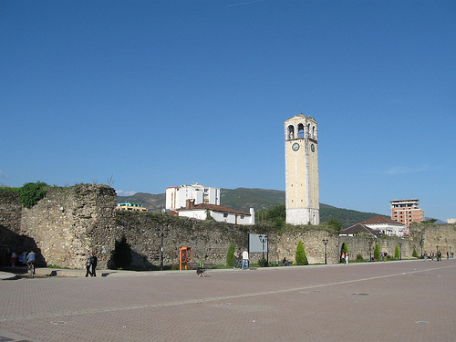
Elbasan Castle is a Turkish citadel
constructed by the Ottoman Turks in the 15th century. It controls
Ancient Roman road Via Egnatia that was in use centuries after its
construction. In addition, the Roman ruins of ancient Roman
buildings were used to build a medieval citadel. Elbasan Castle was
defended by 26 towers and walls 9 meters high. Today this landmark
is open to the public. Here you will find the remains of the Sinan
Pasha's Turkish
baths built in the 19th century, and of course a small restaurant
near the old walls. It is a well-preserved attraction built in the
early 19th century.
Opening Hours, Tickets, and Access
Free entry — No ticket
required.
Open access from morning until sunset (roughly dawn to
dusk). No strict gates or closing times since it’s integrated into the
city.
Some internal sites (e.g., museum) may have their own hours,
typically 9 AM–6 PM.
Best photographed during golden hour
(sunrise/sunset) for warm light on the stone walls.
How to get
there:
From Tirana (most common): ~55 km southeast via SH3 highway.
Drive: ~1 hour. Bus/furgon from Tirana South Bus Terminal: frequent,
cheap (~$3, ~50 minutes).
Taxi or private transfer: Easy and
affordable.
The castle is in the city center—very walkable once in
Elbasan. Look for the prominent walls and clock tower area.
Visiting Tips
Time needed: 1–2 hours for a relaxed walk, or 3+ hours
if including the museum, meals, and people-watching. It’s compact but
rewarding to wander slowly.
Best time to visit: Spring (April–June)
or autumn (September–October) for mild weather and fewer crowds. Summers
are warmer but pleasant for evening strolls. Avoid midday heat in
summer.
What to wear/bring:
Comfortable walking shoes
(cobblestones, some uneven paths and slight inclines).
Hat,
sunscreen, water bottle.
Camera/phone for panoramic shots from
walls/towers.
Modest clothing for religious sites (mosque/church).
Navigation: Streets are narrow and winding—follow the walls or main
gates. Information panels exist, but a local guide (via tours or apps)
adds depth.
Photography: Great spots include the arched gates with
lion fountains, ramparts, and mosque views. Evening lighting on the
walls is magical.
Safety and etiquette:
Albania is generally
very safe for tourists. Standard precautions: watch belongings in
crowded areas, be cautious with traffic outside the castle.
Respect
residents—many homes are private. Greet locals with “Mirëdita” (good
day) for friendliness.
Petty crime is low, but normal urban awareness
applies.
Food and Drink Nearby
Elbasan is known for hearty
cuisine. Try Tavë Elbasani (baked lamb with yogurt sauce). Inside or
near the castle:
Traditional restaurants and cafes in the old
streets.
Coffee culture is strong—enjoy Turkish-style coffee while
watching local life.
Nearby Attractions and Day Trips
Ethnographic Museum and Ottoman hammam (Turkish bath).
Markets and
modern Elbasan boulevard for shopping/people-watching.
Day trips:
Belsh Lakes, Berat (UNESCO town ~1–1.5 hours), or continue to Ohrid
(North Macedonia).
Accommodation
Stay inside or near the
castle for atmosphere (e.g., boutique guesthouses or hotels like Hotel
Ponte, Garden Boutique Hotel). Many options combine history with modern
comfort.
Overall vibe: Elbasan Castle is perfect for travelers who
enjoy authentic, lived-in history rather than polished tourist sites.
It’s a great stop between Tirana and southern Albania, offering insight
into layered Balkan heritage without the crowds of more famous spots.
Ancient and Roman Origins (Pre-4th Century to 6th Century AD)
The site’s history dates back over two millennia. The location was
strategically vital along the Via Egnatia, the major Roman road
connecting the Adriatic port of Dyrrachium (modern Durrës) to
Thessaloniki and Constantinople (Byzantium).
Roman Period: A
military camp or mansio known as Scampis (or Mansio Scampis) was
established here, likely during the reign of Emperor Diocletian
(284–305 AD). It served as a waystation and defensive post for
legions and travelers. Archaeological evidence includes Roman walls,
baths, mosaics, and agricultural activity in the surrounding area.
The original Roman fortification was rectangular, roughly 348 by 308
meters, with walls about 3 meters thick.
Byzantine Period: The
site saw continued use and reinforcement, especially under Emperor
Justinian I in the 6th century, amid threats like Gothic invasions
(e.g., 378 AD) and later Slavic incursions. Settlement periods are
noted from the 3rd–6th centuries and again in the 11th–15th
centuries. The fortress helped protect trade routes and regional
administration during the Eastern Roman (Byzantine) era.
After the decline of the Roman/Byzantine presence (linked to Slavic
invasions and the broader collapse of late antiquity structures),
the site appears to have been largely abandoned for several
centuries.
Ottoman Reconstruction and Peak (15th–19th
Centuries)
The castle as it is known today largely stems from the
Ottoman era. In 1466, during his campaigns against the Albanian
resistance led by Skanderbeg (Gjergj Kastrioti), Sultan Mehmed II
(the Conqueror) ordered a major reconstruction on the ancient
foundations.
Purpose: It served as a military base and
garrison town to secure central Albania, control the Via Egnatia,
and support Ottoman expansion into the Balkans. The Ottomans built a
quadrangular fortress with thick limestone walls (nearly 900 meters
in perimeter), 26 equidistant towers (about 9 meters high), a deep
moat in parts, and four main gates oriented toward cardinal
directions and trade routes.
The name “Elbasan” derives from
Ottoman Turkish il-basan or similar, often interpreted as “the
fortress” or “the flat fortress/province.”
Under Ottoman
rule, Elbasan became the seat of the Sanjak (administrative
district) of Elbasan for about 445 years. It flourished as a vibrant
urban center:
Inside the walls: Mosques (including the King
Mosque/Xhamia e Mbretit, built 1492), churches (Orthodox and
Catholic), Turkish baths (e.g., Sinan Pasha’s hammam from the early
19th century), bazaars, schools, and over 2,000 houses at its peak
in the 17th century. It had a thriving manufacturing sector with
hundreds of shops producing leather, silk, and metal goods.
It
became a hub of cultural and economic activity, with significant
Muslim, Orthodox, and later Catholic communities—sometimes called a
“Castle of Three Faiths.”
The fortress played a role in regional
defense and trade throughout the Ottoman period.
In 1832, the
Ottoman grand vizier Reşid Mehmed Pasha ordered parts of the
fortress dismantled following the suppression of uprisings elsewhere
(e.g., in Bosnia), though significant walls and towers remain.
19th–20th Centuries and Modern Era
During the Albanian
National Awakening (Rilindja Kombëtare) in the late 19th and early
20th centuries, Elbasan emerged as a center of Albanian nationalism
and education. The castle area hosted scholars, printing activities,
and cultural efforts to preserve Albanian language and identity
under Ottoman rule.
After Albanian independence (1912) and
through the communist period (1944–1991), the castle integrated into
the modern city. Parts of the walls were incorporated into urban
fabric, with homes, shops, and cafés built within and around them.
It survived as a living neighborhood rather than a purely preserved
ruin.
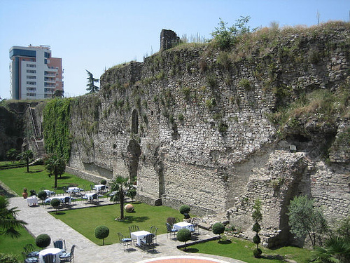
Today, Elbasan Castle is a freely accessible public space
and living historic district in the city center. It features
preserved southern, western, and eastern walls with towers, gates
(including the southern gate with lion fountains), and Ottoman-era
buildings. It hosts cafés, restaurants, the Ethnographic Museum,
religious sites, and cultural events.
Location and Coordinates
Geographic Position: The castle lies on
the north bank of the Shkumbin River (also spelled Shkumbini), at the
eastern end of a fertile, well-watered plain in central Albania.
Coordinates: Approximately 41.1125° N, 20.0822° E (city center; the
castle is in the heart of the modern urban area).
Elevation: Around
128–133 meters (420–436 ft) above sea level, making it low-lying for a
fortress.
Regional Context: It sits between the Skanderbeg Mountains
(to the northeast/east) and the Myzeqe Plain (to the west/southwest), in
the Elbasan County. The site controls a strategic corridor along the
ancient Via Egnatia, the Roman road linking the Adriatic coast (near
Durrës) to Byzantium (Constantinople).
Topography and Surrounding
Landscape
Elbasan occupies a transitional zone in Albania’s diverse
geography:
Riverine Setting: The Shkumbin River is a key feature,
flowing roughly east-west through a broad valley. It originates in the
mountains southeast of Elbasan and eventually reaches the Adriatic via
the Myzeqe Plain. The river provided water, transport, and fertile
alluvial soils for agriculture (olives, corn/maize, tobacco, and other
crops). The castle’s location on the north bank offered some natural
defense while allowing control over river crossings and valley routes.
Plains and Highlands: To the west lies the expansive, low-lying Myzeqe
Plain (one of Albania’s main agricultural areas). To the east, the
terrain rises into the Skanderbeg Mountains (part of the broader central
Albanian highlands), with peaks providing a dramatic backdrop. The city
itself is at the “highlands” edge of the fertile plain.
Terrain
Characteristics: The immediate area around the castle is flat to gently
undulating, which is unusual for medieval fortifications (most Albanian
castles are perched on hills or cliffs). This “flat fortress”
vulnerability was mitigated by massive walls, a deep moat
(historically), and strategic placement along trade/military routes.
The surrounding landscape mixes urban development, agricultural fields,
riverine vegetation, and nearby hills/mountains, creating a mix of
fertile lowlands and rugged highlands typical of central Albania.
Castle Layout and Architectural Geography
The Ottoman-era
fortress (primarily 1466 under Sultan Mehmed II, with Roman/Byzantine
roots) is roughly quadrilateral:
Walls and Towers: Originally
featured thick stone walls with about 26 equidistant towers (roughly 9
meters high). Sections remain standing, especially the south wall, which
now serves as a promenade with views over the city and river valley.
Gates and Moat: Three main gates and a historic deep moat enhanced
defense on the flat terrain.
Inhabited Core: Unlike many ruined
fortresses, Elbasan Castle encloses a living district with homes, shops,
mosques (e.g., King Mosque), churches, and other structures — making it
one of the largest inhabited flat-surface castles in the Balkans.
Area: The walls historically encompassed a significant urban area (over
25 hectares in the broader complex), shaping the modern city’s layout.
The flat topography made it a practical military base and trade hub but
required substantial engineering (walls, moat) for protection.
Strategic and Environmental Significance
Historical Role: Its
position on the Via Egnatia and in the Shkumbin Valley made it ideal for
controlling movement, trade, and military campaigns (e.g., Ottoman
operations against Skanderbeg).
Climate and Environment: Central
Albania has a Mediterranean-influenced climate with hot, dry summers and
mild, wet winters. The river valley supports lush vegetation and
agriculture, though industrial history (e.g., metallurgy) has impacted
parts of the Shkumbin Valley.
Views and Access: From the walls or
towers, visitors see the river valley, surrounding mountains, and the
expanding modern city. The south wall promenade offers particularly
accessible views.