Hotels, motels and where to sleep
Restaurant, taverns and where to eat
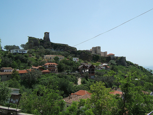
Krujë Castle or Kruja Castle became famous as the last resort of Christian resistance against invading Ottoman Turks. A small garrison of Albanians was headed by an Albanian lord George Kastrioti Skanderbeg. Krujë Castle (Kalaja e Krujës) became known in the country as the last Christian fortress that fell before the onslaught of the Ottoman army. Surprisingly, the small fortress offered strong resistance. During the Albanian uprising of 1432-1436. Krujë Castle was unsuccessfully besieged by Andrea Topii, and Ottoman rule was restored. After the uprising of Scanderbeg in 1443, the castle withstood three major sieges of the Turks, respectively, in 1450, 1466 and 1467, with garrisons usually not exceeding 2000-3000 men under the command of Scanderbeg. Mehmed II the Conqueror himself could not break down the castle’s defenses until 1478, 10 years after Skanderbeg’s death.
Krujë Castle is located at an altitude of 557 meters (1,827 feet) above sea level. Today it is a center of tourism in Albania and a source of inspiration for Albanians. It houses a small museum dedicated to the struggle for the independence of the Albanians. Krujë castle is depicted on the back of the Albanian 1000 Lek banknote in 1992-1996 and on the 5000 Lek banknote issued since 1996.
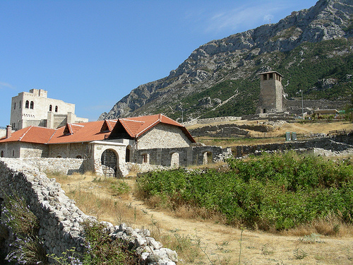
Medieval Hamam (on the southwestern edge of the castle). The steam
bath is another legacy of medieval life in Kruja. The hamam was
built at the end of the 15th century, and consists of four areas:
the changing room, the middle room which has remnants of a tank, and
two separate bathing areas with water supplied by the well of the
square. In the middle of the main room is the kettle where water was
heated. This hamam was used by the city’s elite. In 1963, it was
proclaimed a first degree cultural monument.
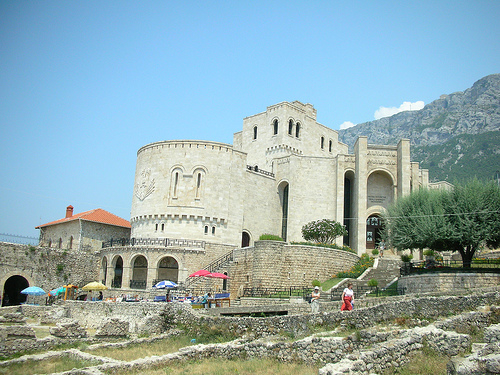
Church of Skanderbeg
(The church in the Castle of Kruja). This church dates to the 15th
century. It is built over the ruins of an older church from which is
saved a part of its frescos. Its existence was found in the 80s
(20th century) during excavations.
The Tower Houses of Kruja.
They are Krutan Buildings qualified as tower-houses because besides
living, they have served also for protection against any possible
aggressor. Such houses can be found in the old neighborhoods of
Kruja .
Faith Mosque (near the Skanderbeg Museum). It is thought
to have similarity with the mosque in the Castle of Preza. It dates
in the end of the 15th century.
Old Bazaar. The Old Bazaar of
Kruja dates to the 17th century and is known by the locals as
Derexhiku. It was built approximately 400 years ago and had about
200 shops starting from neat Kruja City Hall to the entrance gates
of Kruja Castle. The first shops are thought to have started next to
the castle entrance and over the years the shops expanded towards
what is now the center of town. The shops line the street on both
sides creating roads of roof-covered storefronts whose sloping roofs
create an arcade along its length. The main crafts and trades in
these shops have been leather working, silk, kitchen utensils,
furniture, tailoring, pottery, carpentry, cafes, wood carving,
butchers, barbers, shoemakers, blacksmiths, and wool workers. In the
Old Bazaar today you can find objects and handmade items from
traditional artisans as well as antiques collected from Kruja and
the surrounding areas.
Merat Beut Mosque (in the Old Bazaar).
The Mosque was built in 1533 during the Ottoman invasion. It's
unique architecturally, and matches in harmony with the Old Bazaar.
It is also considered a cultural monument. During the Communist
times, the mosque was closed and its minaret reopened once again in
1991, and is visited by locals and foreign tourists alike.
Cave
of Sari Salltëku (at the top of Mount Krujë). The cave of Sari
Salltëku is considered sacred within the Bektashi faith.
Skanderbeg Monument (in the center of town). a monument for the
national hero, Gjergj Kastrioti Skanderbeg. The statue was erected
on November 28, 1959 and was designed by sculptor Pascal Odysseus.
It was officially declared to be a national cultural monument in
1963. The statue depicts Skanderbeg charging into war atop his
stallion with sword drawn.
Albanopolis (in the village of
Zgerdhesh, 5 km away from Fushe-Kruja). an Illyrain city and the
capital city of the Albans, an Illyrian tribe which used to live in
the zone. It is thought to be the city from which Albania and the
Albanians inherited this name.
Nature
Qafshtame National Park (also Qafë-Shtamë). The Qafë
Shtama National Park (Albanian Parku Kombëtar Qafë Shtama, in German
National Park on the Shtama Pass) is located in the foothills of
Albania north of Tirana, around 25 kilometers east of Kruja. It has
an area of 2000 hectares, the majority of which consists of a
beautiful mountain landscape with black pine forests, some small
lakes and important springs. The national park was established in
1996. The name of the park translates as Shtama Pass. The unpaved
road from Kruja to Burrel, which runs through the park, crosses the
mountains at around 1250 meters. There is a small hotel not far from
the pass. A workers' rest home from communist times, in which lung
patients could relax, has fallen into disrepair.
To the north
of the pass road lies the majority of the park, mainly undeveloped
mountain area with forests dominated by pine, beech and oak. The
black pines are up to 20 meters high and 60 years old - one of the
most important occurrences in Albania. The forests offer retreats
for brown bears, wolves, foxes and various birds, but are in fact
not protected from illegal deforestation. The highest points to
which it rises steeply to the north from the pass are the Maja e
Liqenit (1724 meters) and the secondary peak Maja i Rjepat e
Qetkolës (1686 meters). In the north-west and in the south, the area
descends into deep stream valleys. In the south, the park borders
the Dajti National Park.
The most important water source is
called Kroi i Nënës Mbretëreshë (German source of the Queen Mother),
which is known for its clean, clear and healthy water. The legend
connects the spring with the Albanian royal family, who allegedly
had water supplied from this spring every day after tests by a
laboratory in Vienna in 1932 marked it as the best water in the
country. Zogu, who came from the Mat region on the east side of the
pass, owned a piece of land on the pass and is said to have had a
villa built up here. The water is also collected here and brought to
a bottling station a little further down at the park entrance. The
mineral water produced here is sold nationwide under the Qafshtama
brand.
On April 29, 1997, a serious accident occurred in an
underground bunker on the east side of the Shtama Pass. A lot of
ammunition and weapons were stored in the tunnels during the
communist era and were dismantled in the 1990s. As a result of the
collapse of the state order, various people tried to sell the broken
down metals for their own account, with less and less caution being
exercised. As a result, there was an explosion in the tunnel. 23
people were killed, including many young people from a nearby
village.
Hurdha e Kecit (The pond of the nanny-goat) This toponym is present in the territory of Kruja where there are springs and waterfalls. The Pond of Nanny-goat is located in the village of Noje, 6km in the east of Kruja, in one of the ramification of the Dro River. It is a waterfall with a length of 15-20m and with a scenic view. The ledgend of this waterfall states that: Here has lived the beauty of the water (an Albanian myth) which went out every morning in the coast by drying and combing her hair under the sun and would dive again in the afternoon. The residents of this region have used this waterfall as a pilgrimage place because they believed in the curative powers of the waterfall.
The Bovilla Reservoir (Albanian Ujëmbledhësi i Bovillës) is a 4.6 square kilometer reservoir that provides most of the water for the drinking water supply of the Albanian capital Tirana. The reservoir is located in the Skanderbeg Mountains around 15 kilometers northeast of Tirana and southeast of Kruja. In the Bovilla Reservoir, the Tërkuza River is dammed, a source river of the Ishëm, which drains the Tirana plain to the north. The Tërkuza rises east of the outer rim of the coastal ridge, which it crosses in the deep gorge Shkalle e Bovillës, which it crosses between the mountains Maja e Gomtitit (1268 m above sea level) and the Mali i Bjeshit (1239 m above sea level). has formed. The dam was built at the entrance to the gorge. The dam, built from a local conglomerate of gravel and sand, is 91 meters high and 130 meters long. First construction began in 1988, but was interrupted after the collapse of communism. In October 1993 construction continued thanks to the support of the Italian state. After the end of the construction work in 1996, the lake was filled in 1998 and at the same time used for its purpose. The water level varies by seven to ten meters over the course of the year, with the highest level in the rainy winter half-year. In measurements from 2006 to 2008, the greatest water depth was around 45 meters. The difference to the original greatest water depth of 53 meters can be explained by sediments that were carried along by the rivers.
Cave of Bovilla: in the southern part of the Gami Mountain, in the gorge of Bovilla, which divides Kruja from the Tirana district. This cave is not exposed for visitors. Based on researchers this cave is the continuation of the Cave of Pellumbasit of the Dajti Mountain. It is thought to have been inhabited around the 12th and 11th century B.C.E. A distinction of this settlement is the presence of prehistorical pictures which show scenes from that time.
Abdyl Agës Bridge The Abdyl Agës Bridge is between Mount Krujë and Mount Kurçajt in the southernmost part of Krujë and spans the Black River. It is believed to have been built in the early 1800s and is constructed entirely of limestone. The bridge is part of a medieval road that once led through this region and provided a safe crossing for the caravans that passed through.
Kurçajt Bridge is to the south of the Krujë region in the village of Kurçaj. It stretches over the Black River and served as an integral part of an old caravan trail connecting Krujë with Tirana. It was constructed in the late 1700s and is made from staggered stones raised gradually by concrete portions. The bridge was made with a unique asymmetric shape that reaches up to the opposite side like a staircase.
Weeping Gorge 2 km (1.2 miles) from the north of Krujë, along the road that leads to Qafë-Shtama national park is a memorial for martyrs of the Ottoman invasion. The memorial hangs at the edge of a massive gorge overlooking an expansive valley. Historical evidence shows that below these stones are the remains of 90 girls that chose to be thrown into the abyss rather than succumb to the Ottomans on June 16th, 1478.
Black River Canyon between Kruja Mountain and Gamnit Mountain, the Black River Canyon offers a walking and hiking trail with views of waterfalls, rivers, and old ottoman bridges. Within the canyon are the Abdyl Agës Bridge, Black Gorge, Bridge of Kurcajt, and Medieval Steps. This area is thought to have been an important passageway around the 15th century and traces are readily seen in the area today.
"Path of Skanderbeg" The
hike, which can be done my any age, goes 1265m to the highest peak
(the Lake Peak is 1725m. Along the trail, there are numerous streams
flowing from the highest peak of this mountain with icy and
crystalline water. The hike takes about two hours and thirty minutes
and has a 3.71 km climbing distance. At Skenderbeg Mountain, there
are views of the long coastline of the Adriatic, and the visibility
goes to Burrel in Mali i Dejës.
Hiking to Shrine of Sari-Saltik
It is accessible by road, but also by a wonderful hiking
trail.Hiking the entire path from the city center to the temple will
take approximately an hour or an hour and a half depending on speed.
Once at the top you can enjoy the historical temple as well as a few
cafes and restaurants within walking distance, some of which offer
breathtaking views.
Droja River Canyon HikeThis trail is
approximately 1.5km long and takes around 25 minutes to reach the
end. At the end of the primary and secondary trails are beautiful
water features including some waterfalls. The beginning of the trail
can be accessed by car.
In the early Middle Ages, Kruja developed from a medium-sized
castle settlement to an urban center between the 6th and 9th
centuries. Artefacts from this time that were found in graves
testify to the high social status and wealth of those buried. In the
9th century the city was the seat of a bishop named David, who is
attested as a participant in the Fourth Council of Constantinople.
In 1190 Progon founded the Principality of Arbanon with Kruja
Castle as the dominant center. It was the first principality ruled
by an Albanian nobleman. In 1415 Kruja was conquered by the Ottoman
troops led by Sultan Mehmed I. In the middle of the 15th century,
Skanderbeg and his League of Lezha recaptured the city and defended
the fortress from Albania against the invading Ottomans for several
decades. They then attacked the castle repeatedly, for example
during the months-long but unsuccessful First Siege in 1450. Only
after the death of Skanderbeg, the Turks were able to completely
occupy Kruja and all of Albania in 1478 and rule it for more than
400 years. The bazaar mosque was built in the 16th century and is
still standing today. In 1617 the medieval Kruja was devastated by a
strong earthquake.
Kruja was a center of the Bektashites in
Albania. There were several Tekken, of which the Dollmatekke is
still preserved in the castle. On the mountain above the city, in a
cave, is one of the alleged tombs of Sari Saltik, a saint of the
Bektashi order, which is visited by pilgrims of various faiths. Sari
Saltik is said to have worked in Kruja.
The first hospital
was built in 1946 and a polyclinic in 1948. Between 1968 and 1969 a
medicine laboratory and a surgery department were added. In 1970 the
Rectorate for Hygiene and Epidemiology of the Kruja District was
established. A new hospital was built between 1977 and 1979. In 1986
the obstetrics and gynecology hospital opened its doors. In 2008 the
older hospital was renovated and named after its first director
Stefan Gjoni.
There are many buses to Kruje from Tirana. The trip lasts about one hour. The town is easily accessible by direct bus from Tirana. The trip takes approximately 45 minutes, costs 100 Lek each way, and departs from the bus station North Stacioni Autobusave Zona e Veriut, 15 minutes walking distance from Skanderberg Square. Current bus departure times from Tirana are 10AM, 11AM, 1PM, 4PM, 5PM, 6PM, but are subject to change. From Shkodër and Durrës take a bus or furgon to "Fushë Kruje" which is directly at the motorway to Tirana. From there is a local bus every 15 minutes to Kruje (running from 6 AM to 9 PM, costs 30 Leks, as of 2013).
Kruje is small enough to get around on foot very easily. It is built on a mountainside, with the one-street bazaar the central attraction, and the renovated castle just above and to the south.
Hotel Panorama (Near the Old Bazaar). Rooms have a view over the city and restaurants are on the property.
Bar Restaurant Panorama located near the castle features typical
local dishes such as Pule me Qull (village chicken), and Kabuni.
Taste local Raki made from cornelian cherry and blackberries.
Restaurant Bardhi. Restaurant Bardhi, situated near the National
History Museum G.K. Skanderbeg, offers traditional Albanian dishes
for lunch and dinner along with spectacular views. Outdoor and
indoor seating is available
Restaurant Alba. Restaurant Alba is
located across from the GK Skanderbeu National History Museum.
Traditional local and Italian dishes are served in an ambient
setting with indoor and outdoor options available
Merlika
Restaurant. Located within the castle, Merlika offers a local menu
and pizza in traditional-styled dining.
Eli Bar Restaurant
Located in the Old Bazaar, Eli Bar Restaurant offers a wide menu of
traditional Albanian foods.
Restaurant Kalaja. Sit on the second floor and enjoy a beautiful panoramic setting while tasting a wide range of Albanian wines.