Location: south of Vlora
Llogara Pass is
a protected national park located between Vlora and Dermiu. You can
get here by traveling south from Vlora to the Llogara Pass, which
reaches a height of over 1000 meters. The native animals of the
Llogara Pass include wild boars, deer, wolves and many others. In
addition, the local peasant herdsmen still have large flocks of
sheep, goats and other animals, despite the fact that the villages
of Albania are clearly emptying. Be careful when you go camping in
the park Llogara. Some hillsides can become very slippery,
especially after heavy rains.
Llogara National Park (Albanian: Parku Kombëtar i Llogarasë) is
a national park located on peaks along the Albanian Riviera in
South-Western Albania, covering an area of 1010 hectares (10.1
km2). The territory of the park includes large alpine meadows, steep
rocks, precipices and dense forests. Llogara was created in 1966
to protect several ecosystems and biodiversity of national
importance. The International Union for Conservation of Nature
(IUCN) has included Llogara Park in category II. Llogara National
Park is distinguished by an exceptional variety of landscape from
the alpine peaks of the Keran mountains covered with snow in winter
to the sunny Albanian Ionian Sea. At 1,027 m (3,369 ft), the Llogara Pass has stunning landscapes with high mountains
overlooking the Albanian Riviera and several islands in the sea. The
region is dominated by a Mediterranean climate. This means that
summers are hot and winters are usually dry and temperate. Despite
its proximity to the Mediterranean climate region, the alpine
climate prevails in the Maya e Chicés region. Geomorphologically
carbonate rocks occupy most of the area, while the mountains consist
of limestone and dolomite.
Tourism is the most important
sector in the park of Llogara Pass. It has the greatest potential
for sustainable income. Along National Road 8 there are several
restaurants, hotels, and more. The area of the park and the
surrounding mountains are covered with a web of walking paths. The
Caesar Pass, named after Julius Caesar, is located at the Llogara
Pass. According to him, the great Roman commander spent his army in
pursuit of Pompey.
Topography and Elevation
The pass reaches 1,027 m (3,369 ft)
elevation (some sources note ~1,043 m), making it the highest point on
the main coastal route (SH8) between Vlorë and Sarandë. The Ceraunian
Mountains extend ~100 km northwest-southeast, rising abruptly from the
Ionian Sea. They divide at the pass into the main range (east/north) and
the western Reza e Kanalit (Akroceraunian Mountains) extending into the
Karaburun Peninsula (~24 km long, 4–7 km wide).
Park elevations range
from ~200 m near the coast to peaks including Maja e Çikës (2,045 m /
6,709 ft)—the range's highest—and Maja e Qorres (2,018 m / 6,621 ft).
The pass itself is a saddle between Maja e Çikës and Maja e Gjipalit (or
nearby peaks). Terrain includes steep precipices, vertical rock faces,
alpine meadows, and dense forests; the southern slopes drop dramatically
(>1,000 m over ~3 km) to the coast, creating dramatic relief. The pass
acts as a watershed divide: drainage north feeds the Adriatic (via Vlorë
Bay/Dukat Valley), while south flows to the Ionian Sea.
Geology
The mountains consist primarily of carbonate rocks (limestones and
dolomites) with Mesozoic-Paleozoic carbonic and flysch deposits. The
pass lies along a tectonic uplift line separating the Sazan zone
(southwest) from the Jonike zone (northeast), part of the broader
Dinaric-Hellenic orogenic belt. Karstic features, steep faulted slopes,
and rapid elevation changes from sea level to alpine heights are
characteristic.
Climate
The area has a Mediterranean climate
with subtropical influences: hot, dry summers (mean July ~32°C / 90°F)
and mild, moderately rainy winters (mean January ~12°C / 54°F). Annual
precipitation is 1,000–1,200 mm (39–47 in), varying with elevation and
exposure. Higher altitudes (e.g., Maja e Çikës) experience alpine
conditions with winter snow. Prevailing winds, especially through the
pass, shape vegetation (e.g., flag-like trees). The park remains
accessible most of the year due to limited extreme weather.
Flora
and Vegetation
The park lies in the Illyrian deciduous forests
ecoregion (Palearctic Mediterranean forests, woodlands, and scrub
biome), with high biodiversity and endemism from latitudinal position
and extreme altitudinal gradients (~1,800+ m relief). It marks a
geobotanical transition: Mediterranean maquis/shrubs below the pass
grade into mountain mixed forests above. Dominant species include
Bosnian pine (Pinus heldreichii), black pine (Pinus nigra), Bulgarian
fir, silver fir (Abies alba), ash (Fraxinus spp.), and kermes oak
(Quercus coccifera) on limestone/dolomite substrates. Dense pine-oak-fir
forests cover much of the area, with alpine meadows higher up. Iconic
wind-deformed "flag trees" (e.g., Pisha e Flamurit, a shaped pine)
result from strong air currents.
Fauna
The park is an
Important Bird Area and Important Plant Area. Notable vertebrates
include birds of prey like golden eagle (Aquila chrysaetos) and griffon
vulture (Gyps fulvus), rock partridge (Alectoris graeca); mammals such
as roe deer (Capreolus capreolus), fallow deer, chamois (Rupicapra
rupicapra), wolf (Canis lupus), red fox (Vulpes vulpes), European
wildcat (Felis silvestris), red squirrel (Sciurus vulgaris), and otter
(Lutra lutra). Larger carnivores and raptors benefit from remote,
forested habitats.
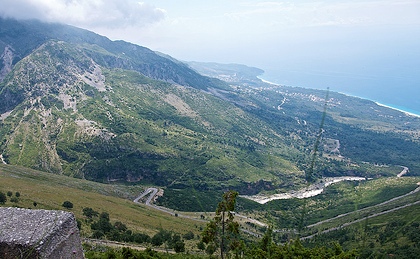
Road and Human Geography Aspects
The SH8
national road traverses the pass: a ~31.5 km section from Dhërmi to
Dukat i Ri (ascent ~22.8 km with ~1,013 m gain, average ~4.4% gradient,
max ~11%). It features tight hairpin turns, narrow sections
(historically single-lane/dirt until paving improvements post-2009;
original road ~1920, reinforced in WWI), and limited barriers, requiring
cautious driving with frequent braking/gear changes. Animals (sheep,
cattle) may cross. A newer ~6 km Llogara Tunnel (under the pass,
completed in phases ~2021–2023+) provides a faster bypass for through
traffic.
The road is renowned for scenic driving with sweeping views
of the Riviera coastline, Ionian Sea, islands (e.g., Sazan), and
mountains. Viewpoints like "Panorama Llogara" offer photo stops; the
pass serves as a paragliding launch site.
Llogara Pass and its
national park showcase Albania's dramatic coastal-orogenic geography: a
compact but vertically diverse zone (~10–17.69 km² park area per
sources; commonly cited ~10 km²) blending Mediterranean coastal
influences with alpine interiors, tectonic history, and rich
biodiversity. It provides exceptional panoramic contrasts between high
peaks and the sea, making it a key natural and touristic landmark.
Llogara Pass (Albanian: Qafa e Llogarasë, locally Llogora) is a
dramatic high mountain pass at 1,027 m (3,369 ft) elevation in the
Ceraunian Mountains (Mali i Ceraunit) of southern Albania. It forms part
of the Albanian Riviera landscape, connecting the Dukat Valley and
Orikum/Vlorë region in the north to the coastal villages of Palasë
(Palaeste), Dhërmi, and Himarë in the south. The pass offers sweeping
panoramic views over the Ionian Sea, the Karaburun Peninsula, islands
like Sazan, and the rugged coastline below. It lies within Llogara
National Park (established 21 November 1966, covering about 1,769
hectares initially, later expanded), which protects diverse ecosystems,
forests (notably black pine), wildlife, and biodiversity.
Ancient
History (Illyrian, Greek, and Roman Periods)
The region was inhabited
by Illyrian tribes from prehistoric times, with evidence of settlements
and hill forts in the Ceraunian Mountains. Nearby Oricum (Orikum) was an
important ancient Greek colony (founded by Euboeans or Corinthians
around the 6th–5th century BC), later an Illyrian and Roman port at the
northern foot of the pass in the Dukat Valley. The pass itself provided
the primary overland link from Oricum to Palaeste (near modern Palasë
beach) on the southern side of the Acroceraunian/Ceraunian range,
bypassing the Karaburun Peninsula.
The most famous historical event
occurred during the Roman Civil War (49–45 BC) between Julius Caesar and
Pompey. In late 48 BC (winter), Pompey controlled most Adriatic/Illyrian
ports, forcing Caesar to land his legions secretly at the remote beach
of Palaeste (described in Caesar’s own Commentarii de Bello Civili, Book
3.6). Caesar’s forces then crossed the difficult, mountainous Llogara
Pass — noted by Caesar for its harsh winter conditions and steep terrain
— to surprise and capture Oricum, which became a key supply base for his
campaign toward Dyrrhachium (modern Durrës). This crossing is locally
commemorated as Caesar’s Pass (Qafa e Qesarit) or Caesar’s Trail, with
hiking routes that approximate the ancient path. The event underscores
the pass’s strategic military value even in antiquity.
Medieval
and Ottoman Periods
During the medieval era (Byzantine, Slavic, and
early Albanian principalities), the pass remained a key but arduous
route for local travel, raids, and limited trade. Under Ottoman rule
(from the late 15th century onward), it gained renewed importance as a
strategic overland corridor for commerce between inland Albanian
territories and Ionian Sea ports (trade in goods, livestock, and
agricultural products). It also served military communication and troop
movements. The rugged terrain offered natural defenses, and nearby
villages developed traditions influenced by passing merchants and
soldiers. Isolation due to the mountains meant coastal communities (like
Himarë) often had stronger maritime ties to Corfu and Greece than
overland links to central Albania.
Early 20th Century and Wars of
Independence
After Albania’s declaration of independence in 1912, the
pass featured in regional conflicts. During the Himara Revolt (November
1912), a Greek military unit occupied positions on the Llogara Pass to
defend the Himarë region against Ottoman-Albanian forces advancing from
Vlorë. The road was rudimentary (mule tracks and basic paths) until
improvements began in the 1920s under King Zog I’s monarchy, aiming to
better connect northern and southern Albania.
World War II,
Communist Era, and Infrastructure Development
During World War II,
the area was involved in Albanian partisan resistance against Italian
(1939–1943) and German occupation. The pass served as a route for
guerrilla movements; remnants of wartime structures and bunkers remain
visible. A notable Partisan Memorial (a mosaic-decorated communist-era
monument) stands near Dukat/Llogara Pass, commemorating resistance
fighters and key local battles (e.g., broader context of actions around
Drashovica and liberation in 1944).
Under Enver Hoxha’s communist
regime (1944–1985), the pass saw heavy militarization as part of
Albania’s isolationist defense strategy: thousands of concrete bunkers
were built nationwide, including along the pass and coast. The road was
asphalted around 1970, improving connectivity. Llogara National Park was
officially declared in 1966 to protect the unique high-altitude forests,
flora, fauna, and scenic value within the Ceraunian range.
Post-Communist Era and Contemporary Significance
After the collapse
of communism in the early 1990s, the road deteriorated but underwent
major reconstruction and widening, especially after 2009–2010s, making
it safer (paved, guardrails, viewpoints, and passing areas). It is now
part of National Road SH8, a highlight of the Albanian Riviera drive.
Tourism has boomed: the pass is a major viewpoint stop, paragliding
launch site (host of international championships), hiking hub (including
Caesar’s Trail), and gateway to Riviera beaches. Restaurants and vendors
at the summit sell local honey, mountain tea, and raki while visitors
enjoy the views.
The pass symbolizes Albania’s dramatic geography,
historical role as a crossroads, and resilience — from Caesar’s legions
to partisan fighters and modern tourism. It is frequently listed among
Europe’s most scenic mountain roads.