Narachanski National Park is a nature preserve around lake Narach in
Belarus. It was established on July 28 1999 to protect a biosphere
around the lake and its wetlands. Narachanski National Park covers
an area of 87,000 hectares. Narachanski National Park is a fairly
popular Belorussian park with several lakes, rivers and patches of a
virgin forest spread through the region. It offers a chance for
horseback riding, hiking, camping, fishing, swimming and other
activities. Visitor center for Narachanski National Park is located
in a town of Naroch that stands on the shores of Naroch Lake.
Additionally Narachanski National Park contains several historic
buildings. One of the oldest signs of human settlement is a small
fortress on the island in the middle of the Myadel lake (Мядель)
that date back to the 11th century.
Other notable buildings
include Catholic Church of Our lady of the Scapular (17th century)
in Myadel, Saint Andrew's Church in the village of Naroch, Saint
Nicholas Church and a wooden church in the town of Svir, Carmelite
Monastery (17th century) in the village Zasvir and many others. A
network of well marked hiking trails is spread across Narachanski
National Park. It makes access to all parts of the protected bio
reserve very easy.
Narachanski National Park (Narochansky National Park;
Belarusian: Нарачанскі нацыянальны парк) is located in the northwestern
part of Belarus, primarily in Myadel and Vileika districts of Minsk
Oblast, with parts in Postavy District (Vitebsk Oblast) and Smorgon
District (Grodno Oblast). It forms part of the Belarusian Lake District
(Poozerie/Belarusian Poozerie).
The park is named after Lake Narach
(Naroch), Belarus's largest lake (79.6 km²). It spans approximately
87,000–93,300 hectares (about 933 km² as of some 2015 data), with water
bodies (including 43 lakes) occupying roughly one-fifth of the area. It
is zoned into a strict protected core (around 8.4%),
recreational/sanatorium areas, and economic zones, classified as IUCN
Category II.
Geological origins trace back 15,000–20,000 years to the
retreat of the Valdai Glacier, which sculpted a hilly-morainic landscape
with numerous glacial lakes, ridges (e.g., Sventsyansky ridges,
Narochansko-Myadel upland), lowlands, forests, meadows, swamps, and
wetlands. Lakes belong to the Neman and Western Dvina basins; major
groups include Naroch (with Naroch, Myastro, Batorino), Myadel, Bolduk,
and Svir. Rivers like Stracha, Narochanka, Uzlyanka, and Sviritsa flow
through. Forests (pine, birch dominant; subtaiga broad-leaved-spruce)
cover much of the land.
Pre-modern human history: The fertile,
resource-rich area (abundant fish, game, forests) has long attracted
hunters, fishers, explorers, and adventurers. Archaeological features
include ancient hillforts, burial mounds, and historic estates/churches.
In the early 20th century (late Russian Empire/ interwar Polish period,
when Lake Naroch was in Poland 1921–1939), development included private
villas, a restaurant, yacht club, marina, and suburban train access,
establishing it as a recreational destination.
The region saw major
military activity during World War I with the Lake Naroch Offensive
(March 1916), a large but unsuccessful Russian attack on the Eastern
Front against German forces, resulting in heavy casualties; the area has
broader military history but this is not central to its protected
status.
Post-WWII Soviet era (1940s–1980s) marked rapid resort and
scientific development. In 1946, a scientific expedition discovered
mineral springs and therapeutic sapropel muds in lakes like Kuzmichi,
Shvakshty, and Dyagili, spurring balneotherapy resort growth. That same
year, the Naroch Biological Station (named after G.G. Vinberg in 2006;
now an Educational and Research Centre of Belarusian State University)
was founded on the northern shore (initially ~10 ha) on the initiative
of hydrobiologist L.A. Zenkevich. It became Belarus's first biological
station, focusing on hydrobiology, long-term monitoring of Lakes Naroch,
Myastro, and Batorino, eutrophication studies, water quality, and
recommendations for preservation and rational use.
Late 1950s–1960s
saw construction of tourist camps, holiday homes, and the Sanatorium
Naroch (opened 1963), followed by others like holiday house Naroch and
children's camp Zubrenok. By the 1960s–1970s, the area became Belarus's
largest health resort zone, with ~11 sanatoria and centers, leveraging
clean air, lakes, mineral waters, and muds.
Scientific work at the
Biological Station (part of International Biological Program efforts
1964–1974) led to Lake Naroch's inclusion in international lists of
reservoirs needing special protection against pollution and
anthropogenic impacts. Monitoring addressed eutrophication, schistosome
dermatitis, recreation zone degradation, and produced
recommendations/plans for basin resource use and protection.
By the
late Soviet and early independence period (1980s–1990s), threats
intensified: thoughtless economic activity, disorganized mass
recreation/tourism, unchecked poaching, pollution, eutrophication,
mismanagement by authorities, and neglect risked irreversible damage to
the unique ecosystem, biodiversity, and water quality.
Establishment
of the National Park occurred via Decree No. 447 of the President of the
Republic of Belarus (Aleksandr Lukashenko) on July 28, 1999. The primary
goals were to preserve unique natural complexes and landscapes around
Lake Narach (the "gold standard" of Belarusian Poozerie), protect
biodiversity and genetic funds of flora/fauna, restore ecological
balance, counter threats, and enable sustainable scientific,
educational, tourist, recreational, and health uses. It became one of
Belarus's four national parks (alongside Belovezhskaya Pushcha, Braslav
Lakes, and Pripyat). No major formal national-level protected status
existed immediately prior, though scientific monitoring and local resort
regulations provided groundwork.
Post-1999 developments integrated
strict protection with sustainable use. Key additions include the
Dendrological Garden (named after S.A. Gomza, opened ~2002 on
Naroch/Myastro shores; ~400 species of trees/shrubs/herbs, Forest
Museum) and Park of Rare Plants on Cherevki Peninsula (geological
monument; >10 Red Book species). The Blue Lakes complex (13 glacial
lakes, >500 plant species/~30 Red Book) gained key natural botanical
territory status in 2005. There are 36 natural landmarks/reserves (e.g.,
hydrological, biological).
State programs focus on ecological
restoration, infrastructure modernization (beaches, pools, hotels, new
buildings), and tourism under initiatives like "Hospitable Belarus." The
park coordinates partly via the Presidential Property Management
Directorate. Visitor numbers have grown significantly: tens to over
100,000 annually (Belarusians and foreigners), with health facilities
hosting ~140,000 in recent years; nearly 70,000 tourists noted in one
2024 figure. Amenities include ~30 itineraries (hiking, biking, water,
eco-tours, helicopter), 16 campsites, hunting/fishing (regulated),
diving, agritourism, festivals, and 11+ sanatoria (e.g., Priozerny,
Sosny, Naroch).
Biodiversity is rich: ~1,400+ higher plant species
(114+ in Red Book of Belarus, e.g., lady's slipper orchid); diverse
mosses, lichens, fungi. Fauna: 314 vertebrates, including mammals (red
deer, elk, wild boar, roe deer, badger, marten, otter, beaver, mink,
raccoon dog); birds (218 species, 51+ Red Book: bittern, osprey, crane);
fish (~35 species: pike, perch, bream, etc.).
The Naroch Biological
Station continues long-term ecological monitoring (annual bulletins
since 1999) and collaborates with the park on research, education, and
conservation.
Location and Extent
It lies mainly in Myadzyel
(Myadel) District of Minsk Oblast, with extensions into Vileika District
(Minsk Oblast), Postavy District (Vitebsk Oblast), and Smorgon District
(Grodno Oblast). The resort village of Naroch (on Lake Narach's shore)
serves as the administrative center, about 160 km northwest of Minsk.
Coordinates center around 54°51′N 26°44′E (Lake Narach).
The park
spans roughly 34 km north-south and 59 km west-east, with an official
area of 87,134.66 hectares (~871 km²); some sources cite slightly over
87,000 ha or up to 933 km² (possibly including expansions or buffers as
of 2015). Protected core zones make up a portion, with the rest
including sanatoria, economic/recreational areas, and resorts.
Topography and Geology
The terrain is a classic post-glacial
landscape shaped by the retreat of the Valdai (Weichselian) glacier
15,000–20,000 years ago, which formed the numerous lakes, moraines,
hills, and wetlands around 11,000–15,000 years ago. It features hilly,
undulating glacial complexes, shallow depressions, peninsulas (e.g., the
Cherevki Peninsula, a geological natural monument), and extensive
lowlands typical of the Belarusian Lake District. Elevations are modest
(lake-adjacent areas ~150–170 m a.s.l., with local relief of tens of
meters from moraines and outwash).
Wetlands and marshes are prominent
ecosystem-formers, with many protected as valuable complexes. The
landscape combines forests, open water, bogs, and glacial landforms,
creating high scenic and ecological diversity.
Hydrology
Water
bodies cover about one-fifth (~20%) of the park and belong to the Neman
(Nemunas) and Western Dvina (Daugava/Zapadnaya Dvina) river basins.
There are 43 lakes grouped into four main systems: Narochanskaya (Naroch
group), Myadelskaya, Boldukskaya (Blue Lakes), and Svirskaya.
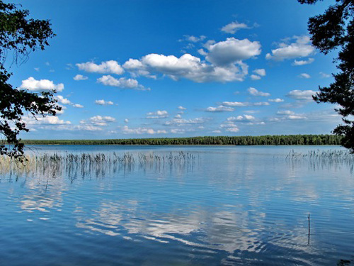
Lake
Narach (Narach Lake) is the centerpiece and Belarus's largest natural
lake: surface area 79.6 km², maximum length 12.8 km, shoreline ~41 km,
maximum depth 24.8 m, average depth 8.9 m, volume ~710 million m³. It
lies in the Viliya (Neris) River basin, is surrounded by pine forests,
and outflows via the Naroch River. It formed post-Pleistocene glaciation
and is part of a connected system with nearby lakes like Myastro and
Batorino.
The Bolduk group (Blue Lakes) is a unique hilly glacial
lake complex with over 10 lakes; Lake Bolduk is among Belarus's deepest
(>46 m). It includes features like the powerful Boltiksky spring
(second-largest in Belarus by power/size). Other notable lakes include
Svir, Batorino, and those with therapeutic sapropel muds (e.g.,
Kuzmichi, Shvakshty, Dyagili).
Rivers include the Stracha,
Narochanka, Uzlyanka, and Sviritsa. Mineral springs (discovered 1946)
and sapropel deposits support balneotherapy and health resorts. The
abundance of water and wetlands supports rich biodiversity (e.g., 220+
bird species, 35+ fish species like pike, bream, perch).
Climate
The climate is moderate continental, strongly influenced by Atlantic air
masses, with cold, snowy winters and cool, moist summers. Annual
precipitation is 650–680 mm (or broadly 600–700 mm across Belarus), with
67% falling in the warm season (April–October); wettest months are
June–July. Relative humidity is high (71–89%). Snow cover persists ~5–6
months (October/November to April), with 75–125 snowy days/year
regionally.
Near Narach: average temperatures range from winter lows
around -7°C (19°F) / highs -2°C (28°F) in January to summer highs ~22°C
(72°F) / lows ~13°C (56°F) in July. Annual mean ~6–7°C; extremes rarely
below -18°C or above 28°C. Growing season ~5.5 months; winds are
westerly/southerly, stronger in winter.
Vegetation and Land Cover
Forests cover a substantial portion (~48% pine and birch groves
dominant), reflecting subtaiga broad-leaved–spruce forests typical of
south-western Belarusian Poozerie. Over 1,400 higher plant species occur
(114 Red Book), plus mosses, lichens, mushrooms, algae, and post-glacial
relic meadows. The park includes 36 natural monuments of national/local
importance and specialized reserves (e.g., Blue Lakes landscape,
Cherevki geological, various hydrological/biological complexes).
Pine
forests surround Lake Narach prominently. The park preserves genetic and
landscape diversity while supporting recreation, tourism, and health
facilities (largest resort area in Belarus with sanatoria).